north pgh
-
Posts
3,009 -
Joined
-
Last visited
Content Type
Profiles
Blogs
Forums
American Weather
Media Demo
Store
Gallery
Everything posted by north pgh
-

Western PA/Pittsburgh Winter 2021/22 Discussion
north pgh replied to meatwad's topic in Upstate New York/Pennsylvania
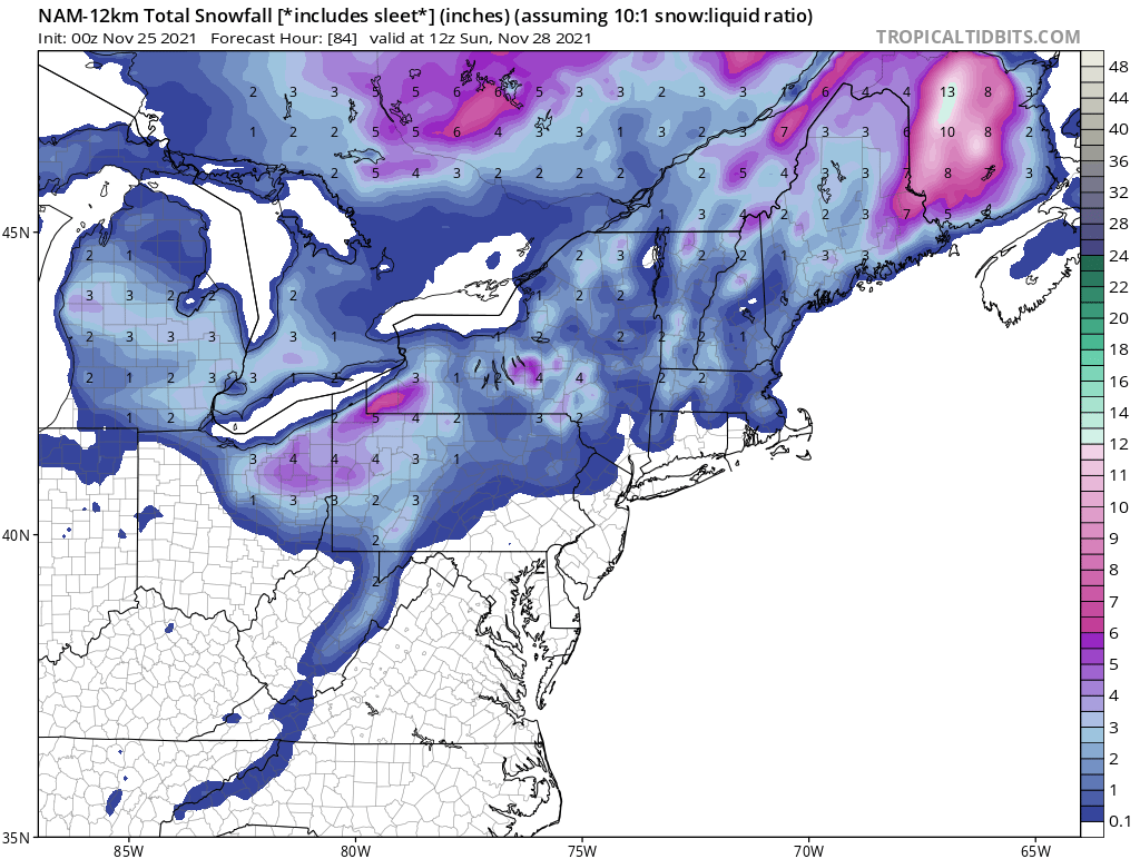
It looks like the NAM is coming around to our potential Friday storm. Now all we need is the GFS and we have something to track. -
Western PA/Pittsburgh Winter 2021/22 Discussion
north pgh replied to meatwad's topic in Upstate New York/Pennsylvania
Merry Christmas all! Let’s hope we can track a double digit snowfall in January or February -
Western PA/Pittsburgh Winter 2021/22 Discussion
north pgh replied to meatwad's topic in Upstate New York/Pennsylvania
After last years great December for snowy weather and a White Christmas, it looks like this year will be a bust. So far I am okay with that. Let's hope we can get a normal snowfall year of 40 inches or so in January and February. I would take that in a heartbeat. Here's hoping. -
Western PA/Pittsburgh Fall Weather Discussion
north pgh replied to Ahoff's topic in Upstate New York/Pennsylvania
I think the long term models will be junk like last year. Likely to change frequently until around 10 days out or closer. Give it a couple days and things will change often. -
Western PA/Pittsburgh Fall Weather Discussion
north pgh replied to Ahoff's topic in Upstate New York/Pennsylvania
Happy Thanksgiving! It's nice to see snow in the air. Picked up a dusting. Any ideas on tomorrow night into Sunday? NWS Pit seems to think 1-2 maybe. Maybe some good snow shower activity into Monday. -
Western PA/Pittsburgh Fall Weather Discussion
north pgh replied to Ahoff's topic in Upstate New York/Pennsylvania

-
Western PA/Pittsburgh Fall Weather Discussion
north pgh replied to Ahoff's topic in Upstate New York/Pennsylvania
I think there is a good chance much of the area may see an inch if a good squall or 2 comes off the lakes. -
Western PA/Pittsburgh Fall Weather Discussion
north pgh replied to Ahoff's topic in Upstate New York/Pennsylvania
I’m driving back from southwest New York this afternoon. I’ll give an update if any snow accumulates on my drive. -
Western PA/Pittsburgh Fall Weather Discussion
north pgh replied to Ahoff's topic in Upstate New York/Pennsylvania
The timing couldn't have been any better. Next time I want to see a snow squall do the same thing. -
Western PA/Pittsburgh Fall Weather Discussion
north pgh replied to Ahoff's topic in Upstate New York/Pennsylvania
Sunday night we may see our first coating at least. -
Western PA/Pittsburgh Fall Weather Discussion
north pgh replied to Ahoff's topic in Upstate New York/Pennsylvania
Yes I agree. I watched that rotation on radar as it went about 5 miles north of me. Duncan ave all the way down to route 8 and then on toward Hartwood Acres. Looking at some damage on the news I’m guessing E-F 1. It could have been a microburst but I think there was too much rotation on radar. -
Western PA/Pittsburgh Summer Discussion 2021
north pgh replied to Ahoff's topic in Upstate New York/Pennsylvania
I like thunderstorms. Nobody on here likes destructive weather as you call it. The line is weakening. General thunderstorms now moving through. Sitting on my porch drinking a beer. Steady rain with thunder and crickets. Great sleeping weather too. Can’t beat it. -
Western PA/Pittsburgh Summer Discussion 2021
north pgh replied to Ahoff's topic in Upstate New York/Pennsylvania
This may be a historic night of thunderstorms. I have had 4 different storms go through in the last 2 hours. This line moving back north has strong winds and intense lightning. Worse than the other storms. Flooding will be an issue. -
Western PA/Pittsburgh Summer Discussion 2021
north pgh replied to Ahoff's topic in Upstate New York/Pennsylvania
For not having any thunderstorms in April and May...... June July and August are overperforming. -
Western PA/Pittsburgh Summer Discussion 2021
north pgh replied to Ahoff's topic in Upstate New York/Pennsylvania
I can't believe the airport hasn't reached 90 today. My car thermometer was 95 and my weatherstation has 92. -
Western PA/Pittsburgh Summer Discussion 2021
north pgh replied to Ahoff's topic in Upstate New York/Pennsylvania
My thoughts exactly. Last night’s storm was one of the better overnight thunderstorms in a while. It was kind of like some storms I remember lying awake to when I was little. Light winds, steady rain and lots of lightning and thunder. No severe wind or hail threat but only lightning strike probability. I was one of those complaining as I myself, like thunderstorms (not too severe however) its been a great 2nd half of June and so far in July. I’m getting some distant rumbling as I type this so we may be in for more today. -
Western PA/Pittsburgh Summer Discussion 2021
north pgh replied to Ahoff's topic in Upstate New York/Pennsylvania
My station is reporting 93. I don't know how accurate but my dewpoint says 74 and heat index is 103. I am looking forward to some thunder tomorrow and 70's later this week. -
Western PA/Pittsburgh Summer Discussion 2021
north pgh replied to Ahoff's topic in Upstate New York/Pennsylvania
My home thermometer just hit 90. With less cloud cover out there now I believe airport should reach 90 today. -
Western PA/Pittsburgh Summer Discussion 2021
north pgh replied to Ahoff's topic in Upstate New York/Pennsylvania
I agree 100%. I live 1 mile next to a neighborhood that lost close to 100 trees in a 5 to six block area. -
Western PA/Pittsburgh Summer Discussion 2021
north pgh replied to Ahoff's topic in Upstate New York/Pennsylvania
Rain is easing up a bit. Picked up .76 inches of rain. A few cloud to ground strikes still around. Keep alert over in Eastern Ohio. HRRR showing a possible second line developing and moving through the metro area in the next several hours. -
Western PA/Pittsburgh Summer Discussion 2021
north pgh replied to Ahoff's topic in Upstate New York/Pennsylvania
Rain pounding here. .56 so far. Winds haven't been too bad. Maybe 45 mph gusts. Flash Flooding may be the new threat as storms training a bit. -
Western PA/Pittsburgh Summer Discussion 2021
north pgh replied to Ahoff's topic in Upstate New York/Pennsylvania
Not so fast. Getting a decent thunderstorm here now with some decent lightning. -
Western PA/Pittsburgh Summer Discussion 2021
north pgh replied to Ahoff's topic in Upstate New York/Pennsylvania
Not looking for severe thunderstorms but would like to sit on the porch and watch some lightning and general thundershowers. The damn warm air aloft strikes again. -
Western PA/Pittsburgh Summer Discussion 2021
north pgh replied to Ahoff's topic in Upstate New York/Pennsylvania
We got hit pretty good here. Luckily my street survived but many neighborhoods around us didn’t. Power just came on. I am guessing a microburst hit. Our winds had to be over 70mph. Trees were uprooted and the ground wasn’t very saturated. Hail was 1 inch diameter. It lasted a good 15 minutes or so. -
Western PA/Pittsburgh Spring Discussion 2021
north pgh replied to Ahoff's topic in Upstate New York/Pennsylvania
For someone that likes thunderstorms, I have yet to see a flash of lightning yet and we are heading into June. Only a few distant rumbles of thunder and some strong winds that’s it. I don’t need severe storms just general pop up thunderstorms with a lot of lightning especially at night.