

RitualOfTheTrout
-
Posts
3,325 -
Joined
-
Last visited
Content Type
Profiles
Blogs
Forums
American Weather
Media Demo
Store
Gallery
Posts posted by RitualOfTheTrout
-
-
1 minute ago, KPITSnow said:
Climate change isn’t politics. Get out of here with that garbage.
I think the point is there are other parts of the board specifically for that discussion.
-
26 minutes ago, Rd9108 said:
Gfs is a crusher fwiw. It's gonna change but again the storm is there. I'd be happy with a 4-8 storm at this point.
Verbatim its more snow at one time than we've had in a year so Ill take it, but a clear signal for mixing. Like to see that primary jump a little sooner as we know the warm nose is often underestimated.
-
1 hour ago, CoraopolisWx said:
Signal for next weekend looking more solid.
And as usual for us, the primary/850 strength and placement is the question.
Hopefully we get a Dec 2020 result, where the primary 850 becomes muted enough not to flood the region with warm/dry air.I like where we sit, GFS and Euro ops get the primary a bit far North I think right now but decent signal for sure.
-
4 hours ago, Rd9108 said:
Enjoy it now because it's gonna change 50 times before then. Signal is there for a snow storm. Game on.
Indeed, still far enough out it could change pretty drastically, some of the individual ensembles barely had a storm or were pretty far east. The Thursday storm needs to get resolved before Id get excited. Just nice to have a legit potential storm, something to give a distraction from post holiday return to work depression lol
Im really looking forward to the next time we get something to track and it keeps looking better and better as we close in.
-
4 hours ago, Ahoff said:
That’s why there’s a caveat, lol. But I’m not sure how 20” in two weeks, could upset anyone. I’m sure we’ll find out though.
Things still look on track for a possible storm on the 7th.
-
 1
1
-
-
3 hours ago, Ahoff said:
There are opportunities. The 7th looks particularly interesting at this point. We’ll see if anything hits.
I agree, the pattern is changing, but that doesn't guarantee a storm, but we should at least have some chances.That 6th-7th storm bares watching for sure. Also maybe a lighter event prior if we can get cold enough.
-
20 hours ago, TimB said:
Its been awful for sure, second least snow for a calendar year on record. Its a low bar, but gotta think we do better between now through mid March.
-
27 minutes ago, TheClimateChanger said:
Look at this cope. 804-hour ensemble mean and control run. I'm old enough to remember when every 384 hour run in the wintertime had more snow than this. For Pittsburgh (and much of the region, for that matter), the ensemble mean looks below average to me. A foot over 35 days in the heart of winter? The control run looks about average, maybe a bit above (16-18 inches around Pittsburgh). Sure this would be a godsend compared to the last couple of years, but it certainly isn't anything unusual outside of the NYC to New England region [which probably won't happen because this is an 804 hour model run].
I love how he focuses on the control run showing 30 inches in NYC - how about it showing an inch in Minneapolis, and only a foot in the UP of Michigan? More snow in west Texas than Marquette?
Those ENS snow maps at that range are pretty useless imho. Swing pretty wildly, prone to being weighted towards a few really bad or really big hits etc. Years past these maps did show more, but it's not like they ever verified then either. They did correct some bad bias'es that made them lean more snowy, so that's at least part of it. Only thing you can really glean is that at least as of that run, the pattern *may* be conducive for above average snow for the month of January.
If its bad I wouldn't lose sleep over it, and if it looked great I wouldn't be teeing up the "It's Happening" Gif either...
-
3 hours ago, PghPirates27 said:
Looks like long range forecast - at least on weather channel app has gone up 3-4 degrees each day since last week. Now mid to high 30's every day after new years. Trending the wrong way.
Pattern changes are chaotic, less certainty on guidance, but also usually rushed. No guarantees of course, but I'm still optimistic we will have better luck in early Jan.
-
1
-
 1
1
-
-
1 hour ago, TimB said:
Who do I have to…well, you know… to get some goddamned snow around here?

Rumor has it its been awhile, no need for details, if it snows we will know you took care of business.

-
 1
1
-
-
Who forgot to check the locks on the asylums back door? Last one out had to much egg nog and a few patients got loose.
-
2
-
-
15 minutes ago, Bubbler86 said:
I think the only people cancelling January are in the MA thread and not many at that. But the OP GFS was not good regardless.
Since Im here Ill take a bit of my own advice, I agree with you, to soon to "cancel" anything. Probably not too soon to debate if the pattern change we thought was coming in early Jan might not be what we thought and it may take to the second half but would that really be that far off from most expectations of a more back loaded winter? Probably not, but those that ride the emotional pendulum with every op run will likely remain insufferable.
-
4
-
-
10 minutes ago, Rd9108 said:
Sorry guys we had a few strays get loose over the Holiday. I'll be sure to round them up for you and take them back home.
Try to find a no kill shelter to drop them off at, but if you can't in this case I wouldn't worry to much about it.

Its one thing to pop into another regions thread and try to contribute, but a whole other bag of worms to whine, complain and troll.
-
2
-
3
-
-
Merry Christmas everyone. Here's to some fun tracking and a big hit in the new year.
-
2
-
-
47 minutes ago, TimB said:
Hard to tell, honestly. You know what I think of the old records but it’s the only records we have so what can you do?
Yeah, I recall the discussion previously on those. They make an interesting data point, but if they are "bad" it certainly skews the warming trend.
I guess you could run those leaving out anything prior to a certain year.
-
Taking a peak at some op runs, starting to see some possibilities now that the pattern change is coming into focus.
-
3 hours ago, TimB said:
With our next shot at getting below freezing not until Friday, we’ve likely clinched a spot in the top 10 fewest December days that have reached the freezing mark, as the best we can do is 13 days if Friday, Saturday and Sunday all get below freezing. Note that only one of the years with 14 or fewer days getting below freezing was observed at KPIT, and it was 2015 which is the standard bearer for awful Decembers.
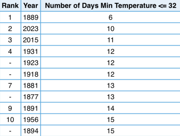
Surprised to see 5 out of 11 of those are pre 1900. Due to poor equipment / record keeping possibly?
-
8 hours ago, TimB said:
I wasn’t impressed with how fleeting the cold was on the GEFS either.
I think we are to far out yet to get a handle on that and this isn't a sustained bitter cold pattern, those often aren't great for storms anyways. You're point is valid though, no guarantee we get into a sustained 2 week pattern that is good, it could be in and out in 5-7 days. I'll reserve judgement on that until we get closer, really no shot at anything for at least another 7 days. Get through that and see how the extended looks then.
I don't put much time into looking at weeklies etc, but they have been decent for January into Feb but they can swing wildly based on how the run they are initiated from ended sometimes so take with a grain of salt.
-
1
-
-
2 hours ago, TimB said:
With that said, the 18z had signs of promise for a second but was then an absolute nightmare.
Why are we looking at op runs past day 5 and swinging like an emotional pendulum?
-
2 hours ago, KPITSnow said:
long range GFS looks not great. Didn’t last year constantly show longterm pattern changes that never materialized?
Yeah, last year did, but to some degree those changes were in contrast to the background Enso state, this year at least the placement of features generally agrees with what you’d expect.
Not saying great times ahead is a guarantee but outside of one GFS Op run everything still looks on track. If it sticks and other ENS start looking similar maybe we have Lucy pulling the football but until then I wouldn’t put much stock in it.
-
The better pattern look is holding in time, next chance for snow sometime after the 28th. I won't say it's a lock yet, but it would be a pretty big fail at this juncture if it falls apart. Hopefully it has some staying power, it would be nice to get locked into a favorable pattern for the first 2-3 weeks of January.
My initial take the ridge axis is maybe a bit to far east which would favor weaker storms to be to far east for us and bomb off the coast, but that could be offset if strong short wave deepens / phases early on. Way to early to hone in on any of that though, but if I had to nitpick...
-
1 hour ago, PghPirates27 said:
Same probably .5 to 1.0"
Same, about .5. Looks like most of the steadier bands missed me overnight. Still got enough to head out last evening and check out some Christmas lights with the family in the snow, so all in all it was a win. I did think we would do a bit better based on the setup.
Hopefully by this time next week a better looking pattern is in the short to medium range with maybe something to track. That would be a great Christmas present!
-
2
-
-
About a quarter inch here so far, next batch of steadier snow about to move in.
HRRR showing a band later tonight with a Huron connection, could give somebody a surprise if that comes to fruition.
-
1
-
-
6 minutes ago, TimB said:
By the end of the week? It’ll be gone by Wednesday afternoon, maybe even tomorrow if we get any sun at all.
If sun angle is a concern on December 19th....
 5 minutes ago, TimB said:
But is retention a reasonable expectation in a Nino, even in the depths of a rockin’ winter?
I guess to add, I think retention (again relative, do you mean 1 day, 1 week?) is reasonable mid Dec - end of Jan assuming you have a pattern that supports cold and a get a couple inches on the ground, otherwise no not reasonable. This situation, not reasonable, we are basically on an island of winter today and tomorrow in a sea of blah. Take what you can get, and try to have some fun in the misery right?
Pittsburgh, Pa Winter 2023-24 Thread.
in Upstate New York/Pennsylvania
Posted
Anyone getting snow? Radar showing some decent returns in some areas. Mostly rain imby so far today, but temp is starting to drop.