

RitualOfTheTrout
-
Posts
3,480 -
Joined
-
Last visited
Content Type
Profiles
Blogs
Forums
American Weather
Media Demo
Store
Gallery
Posts posted by RitualOfTheTrout
-
-
12 minutes ago, Rd9108 said:
Hug the snowiest model. UK has a 970 low off the coast of NYC. GFS trended better but the CMC is less amped now. Still have no idea what impact this will have on us. I'm more intrigued on if we get an earlier changeover tomorrow and get more snow.

Probably a good sign for the Euro then. Should be rolling in shortly.
-
Impromptu sled trip to my parents in southern armstrong. Still ripping snow here 3+, not sure about back home. Great morning!
-
14 minutes ago, north pgh said:
About an inch here too. Still coming down moderate to heavy.
Moderate here again too. Big flakes exploding on contact lol. Some rimming on the flake structure is noted now so mixing is probably about to start.
-
5 minutes ago, Rd9108 said:
Last frame of CMC shows a decent hit and 6z Euro isn't bad either for the big storm.

Looks like 00z Euro and CMC did what jwilison was saying is needed with the faster / cleaner phase. Id take either of those.
Im not sure how much better that could get, but like I said yesterday that interaction isn't going to be resolved well yet, and a relatively minor change will have a big effect on us since we need the perfect phase timing to pull it west.
-
28 minutes ago, north pgh said:
Am I the only one awake? Pouring snow

Nope, just enjoying. Can post about it once the deluge starts.

Looks like at least an inch.
-
 1
1
-
-
Sometimes you just gotta laugh...
-
 2
2
-
-
6 hours ago, jwilson said:
I believe there's a very high correlation between a deep -AO spike relax and a significant nor'easter. Something like 90%? I can't remember off the top of my head, but we just peaked at about -5 on the Arctic Oscillation and will immediately shoot back in the other direction.
That sort of quick-change is volatile. It lends credence to the idea of a major storm occurring soon, but the details are TBD. The one big problem is this not being a Nino, we don't have the typical Miller A southern juice.
We can "fake" that in a way with a big phased element, but I think the overall setup is more tenuous than if this were a typical warm-ENSO pattern with overrunning.
January 1996 was one of those extreme outliers, and we haven't seen that again in the 30 years since, so you know how rare it is.
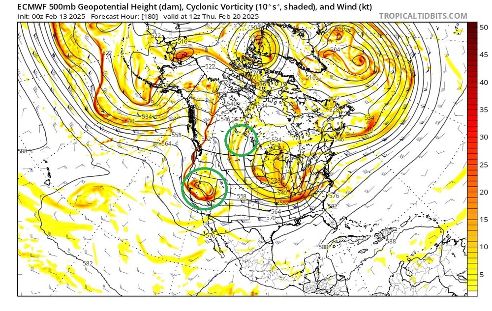
If you get that Gulf of Alaska low to spike that west coast ridge more, or sag the TPV lobe quicker, oriented more north-south, you could trigger an earlier phase that pulls in a more western component to the storm or start developing a wider precip shield. I think that's how Pittsburgh wins from this, but it is more difficult in this overarching pattern, and even 1996 - as the most extreme case - is barely a Top-10 snow for PIT. Granted, there's no history of anything until it happens.
I think a best case scenario is probably like 4-6 if we somehow manage that unlikely earlier phase scenario.
TPV lobes are mercurial poorly modeled variables wherin small changes can have a pretty large impact on storm development and relying on models to have that accurate at this range is setting yourself up for disappointment. Fingers crossed we pull out a surprise.
-
 1
1
-
-
9 minutes ago, Rd9108 said:

Hard to know for sure what is from tomorrow pre change over and sunday back to snow, but I think I can infer a couple are a little further west maybe.
-
31 minutes ago, Rd9108 said:
I had it wrong. It's gonna be a coastal storm. Looking at H5 there's just no way it can get far enough west. Still time but it's looking unlikely.
Theres to many maps and models to keep track of so no worries. I was hoping I was wrong.
I think its possible this *could* come together a little faster and further west which would bring more moisture our way but if I had to bet Id say it goes the other way.
Ill be curious to see if any of the eps individuals show that scenario, or if the op is about the best case.
-
42 minutes ago, Rd9108 said:
Euro shows how we can possibly score atleast a warning event.
But even it being the most amped is like 2-4 inches (based on .3qpf) or am I missing something? Its still pretty far east with the low.
-
6 minutes ago, Rd9108 said:
The flow is just too progressive every time we see a possible big storm. We need to see this phase sooner but right now if I'm the coast I would like where I sit. DC will probably get it's 3rd 6+ storm in the past 2 months.
Honestly our best bet was the storm tomorrow. Once the PV started getting modeled further west which was needed to supress the flow a bit and keep it from going to far NW we were cooked.
Next week always looked like a coastal. Baring some insane perfect timed phase with a piece of the PV the best we can probably hope for is to grab a 4-6 inch type deal off the NW side and even that might be a stretch.
-
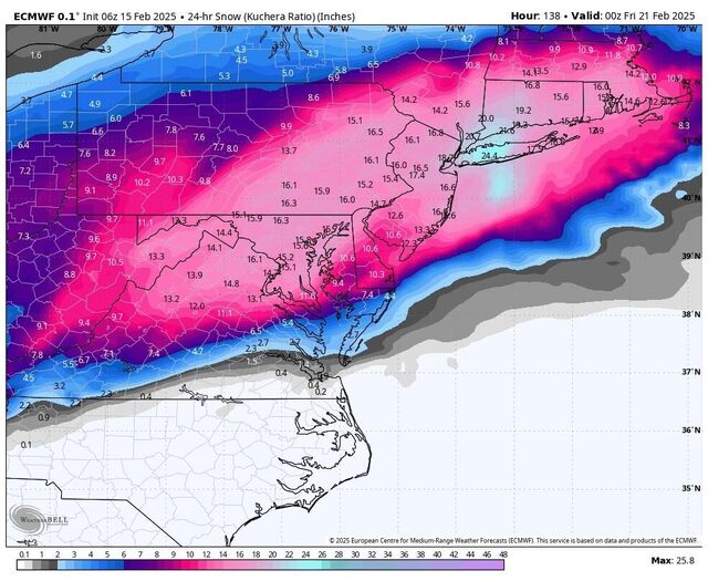
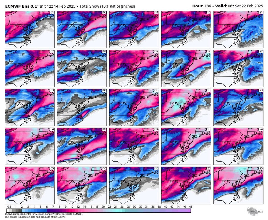
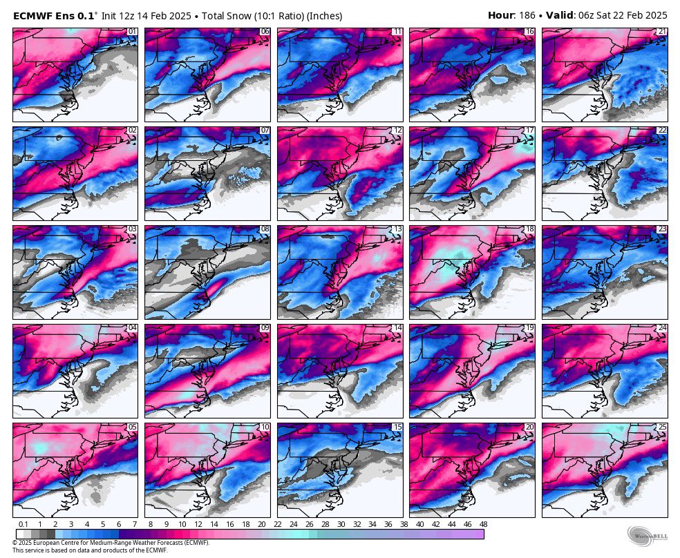
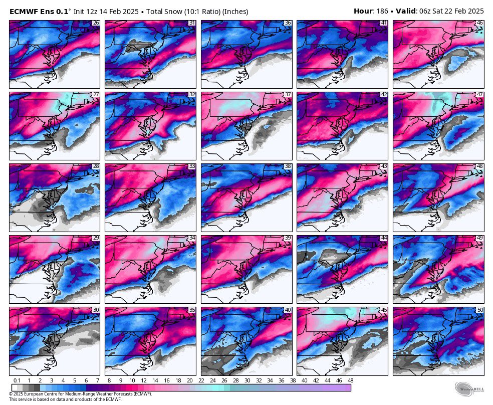
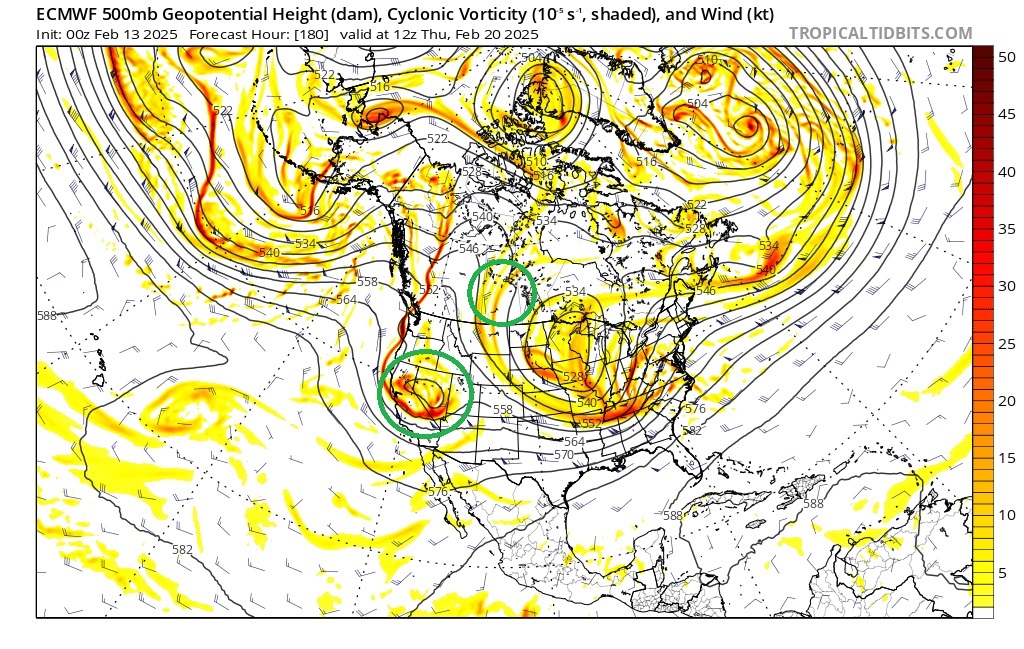
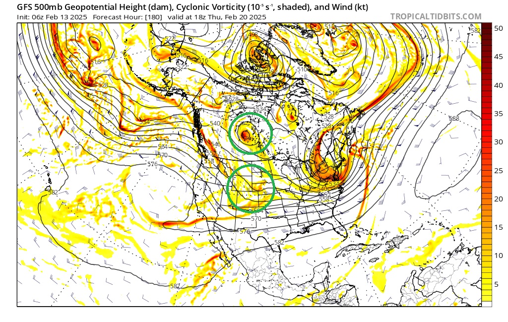
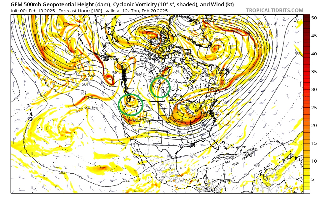
Euro has an interesting setup for the possible storm next week, but a couple key differences with the GFS which is further SE / faster. Euro digs the energy coming in off the PAC into a closed low in the SW partially at least due to the ridge out west not getting knocked down allowing the storm to slow down and consolidate the energy allowing for an almost double barrel type low look getting good snow into our area.
GFS on the other hand has the ridge getting knocked down with that piece in Canada allowing the energy to move east and kick the storm out before it can get it's act together.
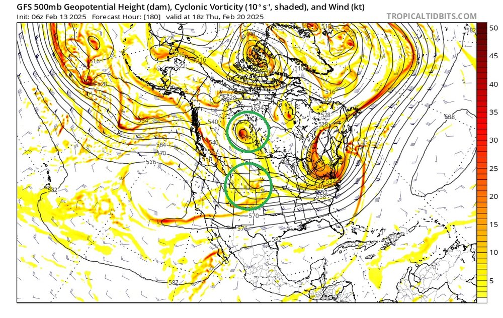
CMC seems a bit slower bringing that PAC energy on shore but also starts to dig it a bit and is much more Euro like.
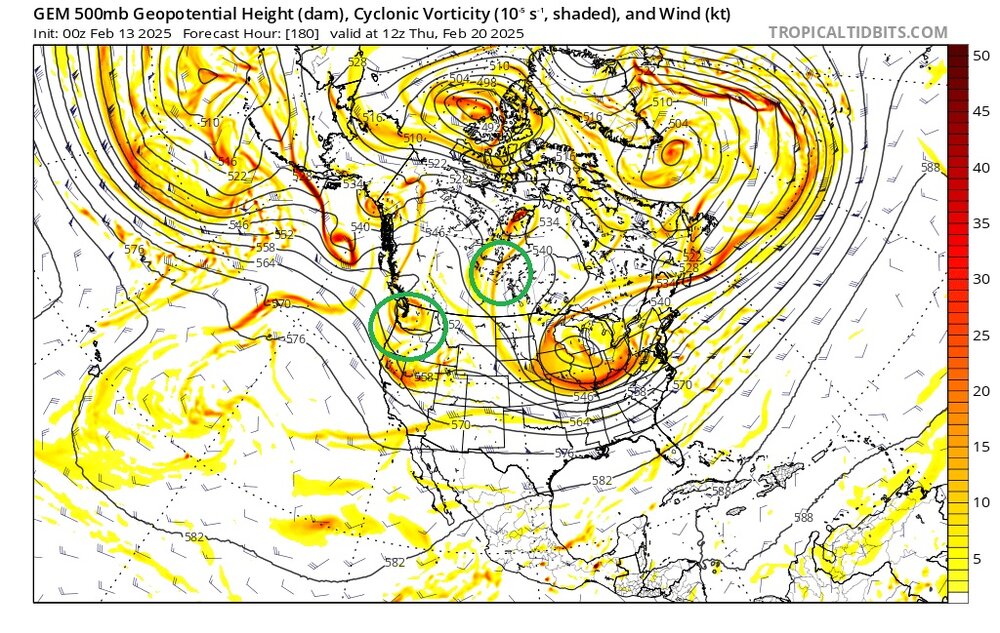
That will be what I keep an eye on as we get closer to this potential. It's been hard to slow the PAC down lately, so my gut says the GFS may be closer to right here, but it's so far out right now some of those variables may not even be there as we close in or something else could manifest to counteract.
-
Maybe some heavy snow / squalls this afternoon and evening. Not much else going on unless you like to track flood watches Saturday into Sunday.
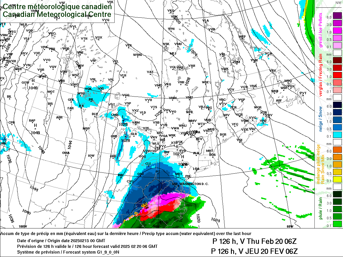
In the wake of the cold front, expected an uptick in snow shower/snow band activity between 4pm to 7pm with a passing shortwave. Hi-Res models depict reflectivity returns of 20DBZ to 30DBZ with snow bands which could create hazardous travel and visibility concerns. The snow squall parameter is also maximized between 20Z Thurs to 00Z Friday over western PA due to steep lapse rates and instability values between 40J/kg to 75J/kg. Short-fused Special Weather Statements (SPS) or Snow Squall Warnings may be needed this evening. Probability of 1"/hr snowfall rates are low (less than 10%) but 0.3"/hr to 0.5"/hr could be embedded within bands. -
20 minutes ago, jwilson said:
Just for fun, this showed up on the long-term GFS Ensembles:

Anyone have a guess as to what that looks like? I'll give you a "hint" -
Sure, Ill roll the dice on a negative tilt full lat trough.

-
5 hours ago, TheClimateChanger said:
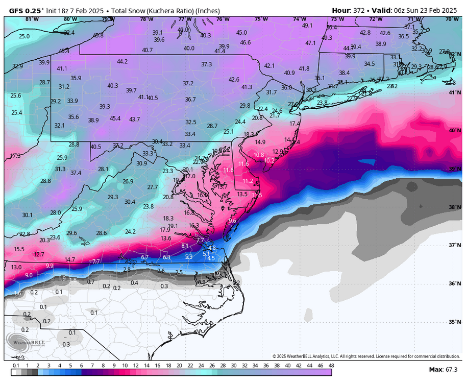
I am always highly skeptical of the totals when they show that sharp linear cutoff along the south edge. I know Joe Bastardi has a saying "you have to be close enough to smell the sleet (or rain?)" but I don't think that's ever been true in our part of the world. Usually the mixed precipitation continues further north cutting down on totals, and there is usually an area where it's snowing but the ratios are pathetic in this type of a setup. It's a subtype of snow that's extremely moisture laden and not very puffy or air-filled and ineffective at accumulating where ratios could be as low as 6:1. Those super sharp cutoffs are usually reserved for the northern edge of the precipitation, like the January 2016 snowstorm. Or, of course, to a smaller extent, with occasional lake effect snow bands which tend to favor some of the northern and northwestern communities. So I'm not super impressed with this depiction, even if it is showing some heavy snow in the northern parts of the metro. I don't think going from inch or two in southern Allegheny, to 8-12 inches in northern Allegheny is a plausible outcome for this setup. More like an inch or two around Pittsburgh, to perhaps several inches up near I-80.
I think he was just showing that map as a "hey, its far enough out, could end up further SE". I agree though, I wouldn't be sleeping easy that close the the southern edge.
GFS does show a decent front end WAA snow, but did nudge back NW for the 15th. I think if that storm was a day or two later it would be a hit. PV is to far west and blocking is just getting established so it is able to cut, roll forward a day or so and it probably gets steered on a better path. CMC on the other hand little WAA snow, but maybe a decent change over Sunday.
Storm on the 20th may be the opposite, blocking might be to strong by then and it gets shoved SE.
To far out for any absolutes, but based on the setup modeled today those are my two fail scenarios. As we know in 6 hours there will be a new set of variables to dissect.
-
Where have we seen this before this season lol. While Im not expecting much, I wouldn't complain if we got a few hours of light snow either.
.gif.561104eb163d8d29c55efc515c8e6c64.gif)
Honestly with the rain coming tomorrow Im kinda glad this is a whiff. In some weird way I get anxiety waiting for the snow to get melted.
Anyways... Definitely an element of bad luck so far.

-
2 hours ago, TheClimateChanger said:
The NAM shows a couple inches tomorrow for the metro area (particularly south), is that possible?
I guess it depends how far South lol. Seems unlikely anything more than half inch or so for the city, but yeah further SE could get into the 1-2 inch range. Going to take a relatively large change given it's only 24 hours away for anyone NW of the city to see much I think. Either way whatever falls is just a "stats padder" as the next system Wednesday looks to be mostly rain right now.
-
Getting some light snow / flurries this morning. Wasn't expecting that.
12z 3k NAM bumped the precip shield a hair north for tomorrow. Not much, but maybe we could eek 1-2 out of it if it bleeds north up to game time. Im not expecting much of anything though.
-
17 minutes ago, Ahoff said:
Shame that a few days ago Tuesday was looking really nice.
Who knows, maybe we get a surprise and the 700mb frontgen band goes 200 miles further north and gets us Tuesday lol
I wouldn't write anything off yet, but we need some changes for the next two after. Not out of the question one or both ends less amped and further south. This season thats been the trend. If it happens and its enough to make a difference here remains to be seen.
-
Pretty much a non event imby. All plain rain, no thunder.
-
2 hours ago, TheClimateChanger said:
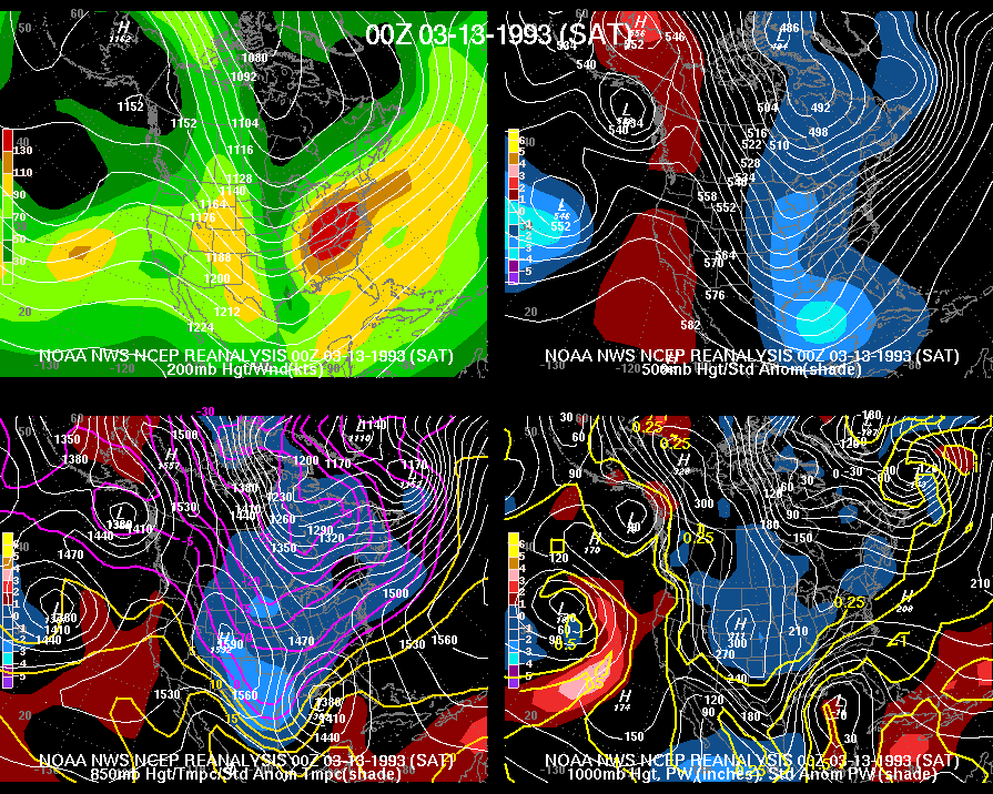
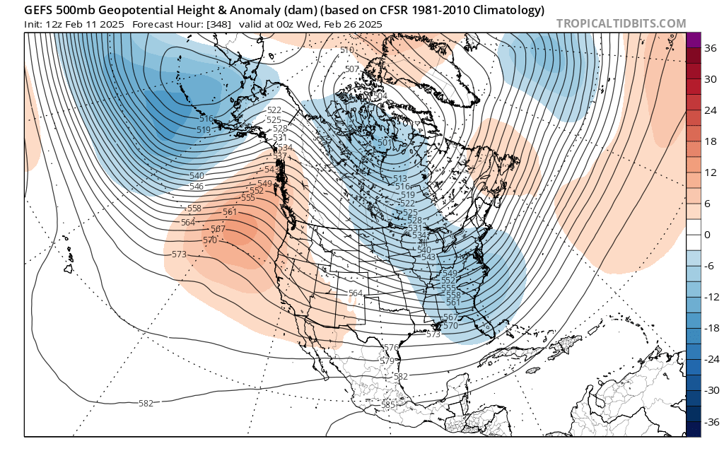
We do need to take these model depictions with a grain of salt. For context, the snowiest 16-day periods on record are shown below. The only times that much snow fell in 16 days were with massive snowstorms in December 1890, January 1978, March 1993, and February 2010. Not even November 1950 had that much snow in any 16-day period, officially.
Oh I agree 100%. I was using it to show the week after next might actually be more favorable if the pattern evolves as depicted. Realistically I think even expecting half that much is a stretch.
-
2 hours ago, Rd9108 said:
All the potential possible but im not sold on the modeled amounts. I guess we shall see but Tuesday already looks like it's trending poorly.
I guess the good part is it looks like after next week is when the better pattern takes hold so if it doesn't work out there's still opportunities to be had. 18z GFS had two big storms actually hit us and a couple little ones pushing 30+ inches.
-
2 hours ago, TheClimateChanger said:
Get a load of this screw zone.

Not a fan of the way things seem to be heading, weaker wave early next week that may whiff to the south then the follow-up is stronger and to far NW vs previously the first wave was a stronger and held less energy back for the second.
Obviously nothing is carved in stone, but not a great look either atm.
-
1
-
-
10 hours ago, north pgh said:
Thunderstorm tonight?
Definitely heard some thunder around 2:45-ish last night.
Overall, the the SW corner of the state the ice was not a big deal as we expected. Probably pretty dicey earlier in the night, but zero issues driving in at 4:30am. As I hear people talking filtering into the office I keep hearing "What happened to the big ice storm?" lol Where do people hear this stuff? Even the evening news was pretty subdued in terms of impacts.
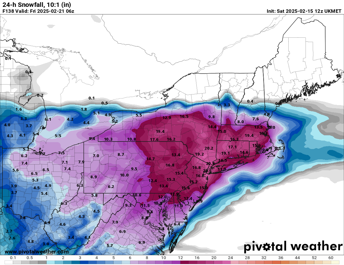
Looks like a repeat Saturday evening? Beyond that, next week we won't know how the boundary sets up until much closer. Update NY / NE looks to get hammered with multiple systems which may not bode well for us being on the right side of things.
Pittsburgh/Western PA Winter 2024-2025 Thread
in Upstate New York/Pennsylvania
Posted
Yep, CMC and Euro both a step back from what we need, sloppy phase. Euro compensates a little with a little stronger southern shortwave.
Really need that clean early phase. Could still move back to that idea.