

RitualOfTheTrout
-
Posts
3,480 -
Joined
-
Last visited
Content Type
Profiles
Blogs
Forums
American Weather
Media Demo
Store
Gallery
Posts posted by RitualOfTheTrout
-
-
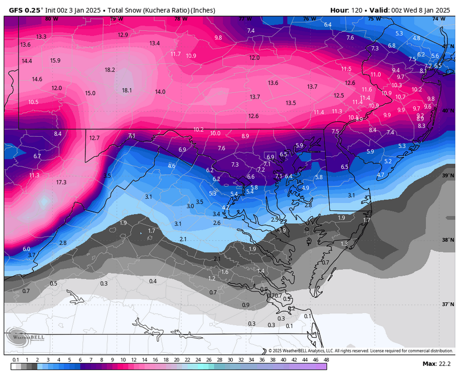
12 minutes ago, Rd9108 said:
Gfs not good. Maybe the euro will help us
My guess is maybe the Euro ticks north, but feels like maybe going to meet in the middle with GFS. Not cooked yet, but starting to think the possibility of a warning event north of i70 is fading.
-
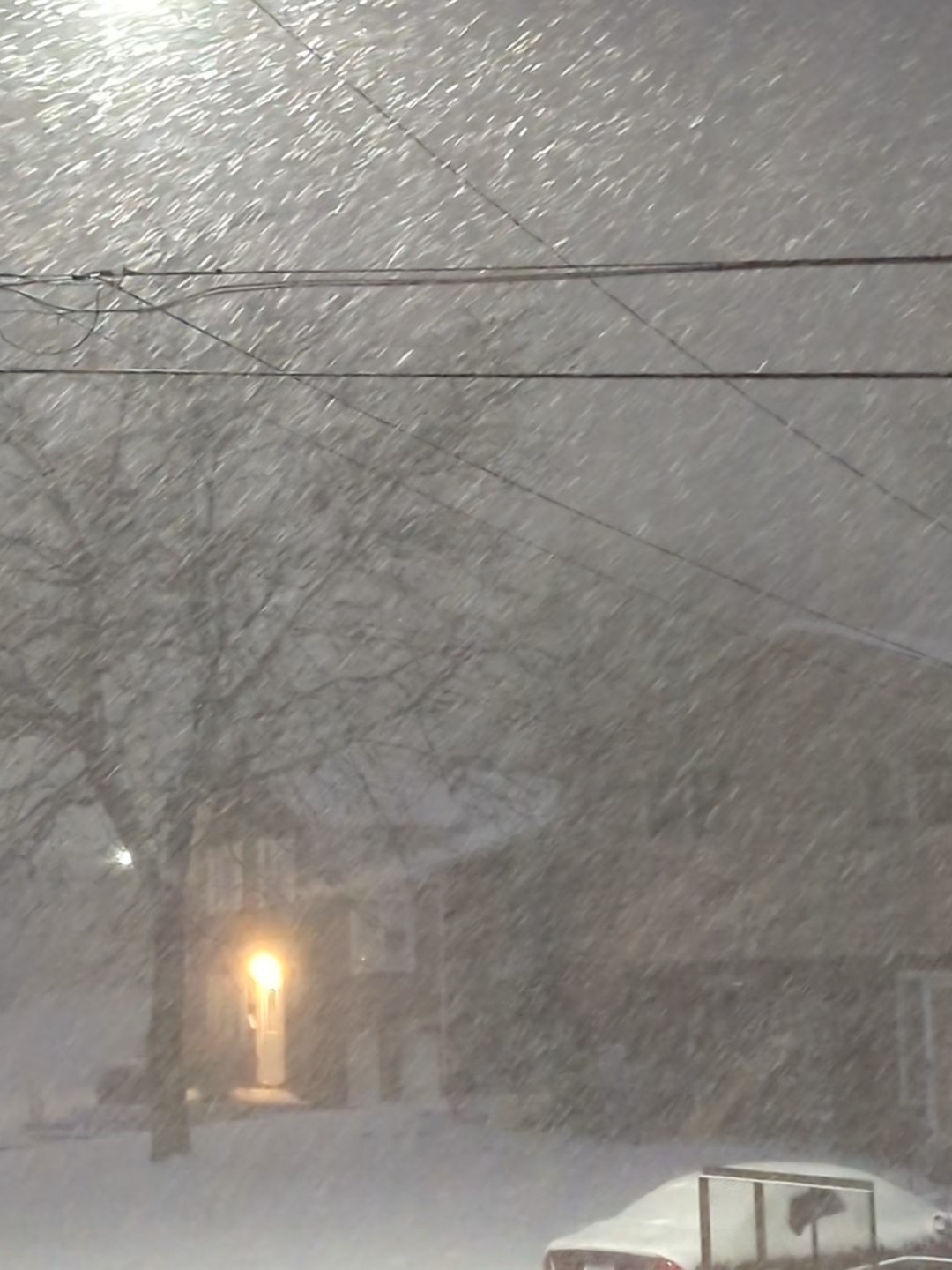
The view out my window...

This squall is crazy!!
20 minutes later... Still puking snow!

-
 2
2
-
-
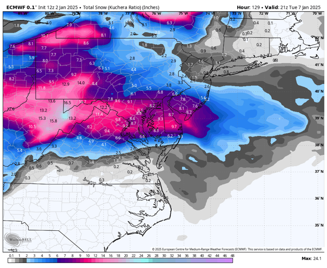
1 hour ago, Burghblizz said:
I can’t count how many times the Euro has jumped 50-100 miles north (to give us slop) within 48 hours. It’s payback time.
It wouldn't shock me if the precip shield ticks North as we close in barring some big change in one of the key players. 18z NAM looks pretty similar to the 12z GFS. Gotta get the Euro more onboard though.
-
Squall on my doorstep...

-
1
-
-
NWS thinks those squalls will make it into our area. Fingers crossed!
As of noon, cold front has reached the eastern edge of our CWA and with its passage, the widespread snow has ended. In the wake of the front, snow showers will continue in NW flow as lapse rates steepen. ACARS soundings note 50-100j/kg of CAPE upstream where a band of intense snow has developed over CLE. Visibilities have dropped to 1/4 or less in the band, which has prompted SPS and SQWs. Latest CAMs do suggest this band will make it into our forecast area before gradually weakening as it shifts east. Outside of the band, deep moisture in the DGZ andi instability will maintain convective showers for much of the afternoon. Will leave the remainder of the advisory/warnings asis given the potential impacts in the heavier showers and squalls but also issue short fused products as appropriate for awareness.
-
1
-
-
1 hour ago, Burghblizz said:
This swath this morning has been on lighter side, but steady. Sitting on about an inch already. Interesting to see how things set up later.
Looks like some more intense stuff starting to fire up near Erie, should be interesting to see how well that translates down here.
-
Looks like everything trended South on the 6z runs with Euro being about an inch north of the city if you remove today's snow. Not the look we want to see continue. GFS at 00z was to amped for comfort last night but still looks to be the furthest north at 6z.
-
5 minutes ago, north pgh said:
There might be some snow squall warnings tomorrow afternoon
Im certainly looking forward to now cast and radar watching and if a squall hits grabbing the dog leash and heading out for a walk.
-
9 minutes ago, Rd9108 said:
Cmc isn't as amped. I kind of like where we sit. Not necessarily for the bullseye but for atleast a warning event. Something we haven't had in awhile. Time for bed. Won't be up for the euro unless we get a call in the middle of the night.
If say GFS is the Northern most goalpost and CMC is the Southern most Im with you, may not bullseye but will a solid event.
-
4 minutes ago, Rd9108 said:
Lmao the gfs sends the mix line right into the area. Let's see what the euro does.
Yeah, the more amped solution I was rooting for can stop now... but damn if this isn't a sweet pass...
-
Nice winter day out there today as well. Overcast with flurries and light snow most of the day with more on the way. Tomorrow could be interesting if you find yourself under one of the more intense bands in the afternoon:
.SHORT TERM /FRIDAY THROUGH SATURDAY NIGHT/... KEY MESSAGES: - Winter Weather Warning and Advisories in effect for most of the region Friday until late Saturday morning. - High confidence in totals for the high terrain with potential for warning criteria accumulations along the I-80 corridor. - Period of convective heavy snow showers are possible during daylight hours that may lead to rapid visibility restrictions and slick roadways. -------------------------------------------------------------------- Rapid transition of an upper level trough through the Ohio River Valley is expected Friday morning. Trough dynamics and weak frontogenetic forcing are expected to form a shield of snow that will be mainly focused along and south of I-70 for roughly the 4am-10am period. As the trough axis exits, steep lapse rates plus developing lake fetches may foster a more convective snow shower environment with favorable DGZ growth as weak instability develops within that ideal zone. Expect widespread (trending toward scattered) heavy snow showers that may exhibit snow squall characteristics (rapid visibility restrictions, quick accumulations) which could lead to tricky travel conditions; notably this ideal convective shower timeframe stretches from roughly 10am-6pm and the incorporates the afternoon commute. Finally, further veering of boundary layer winds to the NW Friday evening into Saturday morning will favor lake streamers, (or bands), that could create localized heavy snow but tend to favor northwest PA and the higher terrain.-
1
-
-
1 hour ago, Rd9108 said:
First winter weather advisory of the year! Maybe we can get a warning on Monday. Latest euro looks pretty solid with room to improve if the precip busts low or the max is further north than modeled.
I think there is still room for the precip shield to expand northward a bit if the confluence is just a little weaker without really affecting the overall track of the storm.
-
1 hour ago, Rd9108 said:
Euro is painfully close but misses to the south. Still time for it to come north but right now our area minus a few posters are on the fringe. Let's see what today shows.
I'm rooting for a stronger shortwave \ more negative tilt to really amp up that moisture transport, we get that and it would take only subtle improvements on that for lack of a better word 50/50 low spinning out in the Atlantic. No matter what, models will struggle to get a handle on any individual spokes of vorticity rotating around that feature which will have a big impact (at least big from our perspective) on just how far north this can get.
Don't want to look past tomorrow either which still looks good for 1-2 inches and maybe some areas of 3 if you get lucky with a follow up LES band.
-
1
-
-
7 hours ago, north pgh said:
I like me some Canadian please.
Nearly perfect track on the 00z GEM. Looks like it's the furthest north right now. Another nudge north on the GFS / EURO would be ideal, but fully expect as we narrow the goal posts to see it wobbling back and forth. Into full tracking mode now, so onto the next runs.
")
-
2 hours ago, Rd9108 said:
Latest trends look good. Not to mention a possible 1-3 Friday. We are now fully in Winter mode. I expect our thread will start to get active in the coming days.
I agree, especially if we can score a moderate event on the front end and add some light refreshers on top it will feel pretty sarisfying after the last couple years.
-
Tonight not disappointing, got under a semi persistent narrow band. May end up with an inch or so.
-
1
-
 1
1
-
-
Including the ensembles, quick cliff notes is pretty much all options on the table between whiff south and so far north we get warm tongued. Fate lies in the ultimate strength of the shortwave but more important how strong and far south the low creating the confluence ends up.
-
2 hours ago, Rd9108 said:
Of course not but we seen things trend north lasts second more so than south. Suppression does happen but id say it's rarer than the warm nose pushing in and screwing us.
Id much rather need less confluence than more at this range. Not to say its a guarantee but typically its overdone in the medium range.
-
I set my bar at if this good pattern is still showing legs by Jan 1st Id start to buy in. For the first time in awhile nothing has changed, and we should have a solid two weeks of tracking at least!
Probably one of the more technical NWS PBZ discussions:
LONG TERM /THURSDAY NIGHT THROUGH MONDAY/...
KEY MESSAGES:

- Late week pattern shift will favor below normal temperature,
  periodic snow, and high terrain gusty wind.
--------------------------------------------------------------------

All the teleconnections point toward sustained cold through the
middle of January. MJO is in phase 7 and moving into phase 8,
which is a cold signal for our area. GEFS show PNA heading more
positive, while blocking near Greenland and high heights has the
NAO going negative and suggesting west coast ridge and east
coast trough. AO showing a negative trend towards a mean of -4
So the dreaded pattern of being well below normal in the coldest
part of the year after two mild winters will make this feel
relatively bad.

Another trough expected with roughly 100 meter height falls
around Friday, which helps drop 850 mb temps from -12C range
toward -16C. Given the flow turns more NW, expect another round
of lake effect snow showers over more of the forecast area.

Saturday looks to be the coldest day this week with temperatures
likely to be about 10F below normal.

Uncertainty then increases substantially for Sunday and Monday.
Timing and details of what looks to be a potent trough
somewhere from the southern Plains to the Great Lakes area will
obviously lead to a snow or ice event that could be significant.
Because there is a wide spread of temperatures and QPF it is
hard to know yet how much impacts there will be in the Upper
Ohio River Valley.
-
 1
1
-
-
4 hours ago, Rd9108 said:
That look disappeared with the 12z. Teleconnections still look good but now we worry more about suppression than cutters.
As we would expect, what I mean by that is expect run to run changes, but you want to see some big looks on the operational runs.
-
2 hours ago, Ahoff said:
Good God, would we love this!

Meh..

-
1
-
-
21 hours ago, Rd9108 said:
Looks like January is shaping up to be cold and possibly stormy. Doesnt mean we will get snow but the pattern looks very promising.
Honestly right now it might be to much of a good thing where NC gets hit, -AO, -NAO, +PNA isn't typically a wet pattern. To soon to nitpick or worry about any discrete details and I am optimistic we will have a decent stretch of winter but thats the one bit of caution I see right now.
Should be plenty of NS short waves and with the lakes still warm we could see several light to moderate snows, with the chance we time something right. There are some hints at the STJ undercutting the ridge out west too which could setup a phased storm somewhere in the east.
-
Just a few flurries / snow showers, sun has been out most of the day. Looks like an over performer for sure for the lucky ones!
-
2 minutes ago, Burghblizz said:
I was thinking the same. Wouldn’t have been disruptive but looked great.
Streamers look to mean business this morning
Around the city and north and west of there based on radar looking like a pretty decent setup currently. Those things can definitely over perform. Think Ill be a little to far East based on wind trajectory.
Pittsburgh/Western PA Winter 2024-2025 Thread
in Upstate New York/Pennsylvania
Posted
Looking at 12z to see if we get any meaningful expansions north, this is typically when the slow bleed north starts to screw us. This time WAA being stronger than forecast may help is unless this is the one time its not.
Im really only looking to not be on the fringe and have a reasonable shot at 3-5.