

RitualOfTheTrout
-
Posts
3,480 -
Joined
-
Last visited
Content Type
Profiles
Blogs
Forums
American Weather
Media Demo
Store
Gallery
Posts posted by RitualOfTheTrout
-
-
On 2/4/2025 at 11:30 AM, Burghblizz said:
I have a really anti climatic Winter Storm Watch. Mostly for ice, and probably northern Butler county. I’ll take some front end snow and skip the ice.
Maybe something to keep an eye on for more of an impact, especially if we stay below freezing all day:
Dry weather and cloudy skies continue through the rest of this afternoon. Light northeast winds and dense cloud cover are resulting in temperatures trending several degrees below what was originally progged in model guidance. Will need to keep an eye on this as it could impact the extent of ice accumulation late this evening and overnight as low pressure approaches and rain overspreads the area from the south and west.-
 1
1
-
-
1 hour ago, Ahoff said:
Of course. The warm nose scenario looks like a really possibility with the way the storms are angled.
Storm middle of next week looks promising at this range. Actually could use a more northern track but these next two look more wet than frozen for sure.
-
4 hours ago, TheClimateChanger said:
Doesn't look like it should be too big of a threat. I know we had an ice storm back in 2021 or 2022, where we lost power for 16 hours, but the temperatures there only climbed to like 33-35F. This event has unbelievably warm air advecting in, with temperatures likely to climb well into the 50s on Thursday, maybe even some 60F readings south of PIT.
This sounds a little ominous for Saturday night, though. Heavy rain and 32F. I wonder if there will be some more freezing rain in the area.

It only takes a light glaze for big problems, but I agree it should be pretty short lived.
-
16 hours ago, Ahoff said:
Wow, a mean at 15-21" area wide! Never saw that.
Pretty crazy agreement. I would add some caution as several the individual ens members show warm nose scenarios too for the various storms. Not trying to be a downer, but I would expect some snow to mix to rain setups while areas not to far north or east get all or mostly snow. Just mentally prepare for that. If the setup is anywhere near to correct though I feel good we finally get a 5+ storm at least and maybe more if we can get an all or mostly all snow event.
-
18 hours ago, TheClimateChanger said:
Nice taste of spring today. 61F here.
I find a lover of all things winter weather, the occasional warm day is much more enjoyable especially when a change back to snow threats is on the horizon. It was nice to get outside and take a walk. Now, I'll be good if I don't see anymore days like that until the end of March.
-
So far so good on the pattern progression into the second week of Feb. If it holds there should be some trackable threats in a few days.
-AO, -NAO, -EPO, and maybe even the PV splitting with a piece getting stuck over hudson bay. If its all correct I could see another 4 week plus window. Adjust for seasonal wavelengths shortening and more warmth south adding fuel to storm development and I like our chances to go out with a bang.
-
 2
2
-
-
On 1/26/2025 at 10:56 AM, Rd9108 said:
Looks like there will be a brief warmup followed by us going into favorable phases again. So I fully expect winter to return. If you are looking for the next snow opportunity then next weekend is the next possible chance. Depending on how much the cold presses will determine if we get anything. After that is the warmup followed by phase 8 of the MJO.
I've been keeping an eye on the MJO forecasts, and its definitely been verifying at a little higher amplitude than what was forecast a few days prior. Now it looks to (albeit still relatively quickly and weakly) traverse through phases 5-6-7, its not a surprise that the upcoming "warm" period looks a little more hostile in terms of the SER and storm tracks being a bit further North. Still not a no hope setup for snow, but given we won't be building any kind of snow pack, I'll certainly have less interest in little 1-2 inch possibilities. I still think mix events will be more likely than all snow and temperatures will be much more variable, but not straying super far from normal in any given day.
Hopefully we get one more reload for the last 2 weeks of Feb into March, that still seems likely but as we know nothing is a guarantee in this hobby.
-
Light snow falling, pretty sure a trace was observed yesterday, so the streak continues!
-
17 hours ago, PghPirates27 said:
Any snow on the horizon over the next 7 days? Looks like we are eventually going to warm up into the mid-30's for a while. Hope we don't get rained out.
The pattern is relaxing, I'd expect temperatures to fluctuate but not deviate to far from normal one way or the other after this weekend. Only little shots at snow over the next 7, less than inch type deals. The next bigger storm threat window looking like its associated with that cutoff low in the SW US over California and when it ejects out and how, ie does it come out all in one piece, or multiple little ones.
GFS and Euro at 00z show it starting to move next week and possibly affect our area by next weekend (Feb 1 - 2) but of course this is all subject to change every 6 hours. The NAO and AO are positive so there isn't any blocking to hold cold air in place so its going to need to be well timed with a northern stream vort re-enforcing the cold or a decent high funneling cold in. This setup is more likely to result in a mixed precipitation type event (slop storm as we call them) as there is a pretty narrow path to all snow given all the things that would need to go right. After the last couple weeks of really maximizing a pretty dry pattern I wouldn't mind a mixed event if its more frozen than wet but we also don't have to stress over a couple tenths of qpf being the max upside.
-
1 hour ago, TheClimateChanger said:
Heavy snow now.
Blowing through here now, definitely more impressive than radar indicated. Less than a quarter inch, but went out during the height of it for a brisk but short walk. Love it!
-
Deep Winter out there.. It's been a great January.
Mixed feeling about the pattern finally relaxing, on one hand wouldn't mind if this kept up, but also wouldn't mind seeing if we can get something more favorable for a bigger storm even if its more variable and less favorable for snow retention.
-
2
-
-
20 hours ago, Rd9108 said:
Yeah HRRR shows a squall through the center of the county. See what happens.
That snow game was fun to watch.
Still looking like some possible impacts tomorrow. NWS thinking less than an inch, but with temperatures this cold a brief burst of heavy snow will deteriorate roads pretty quickly especially later afternoon / early evening.
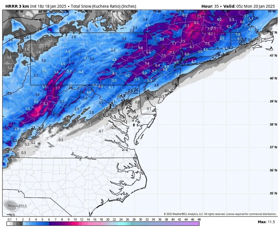
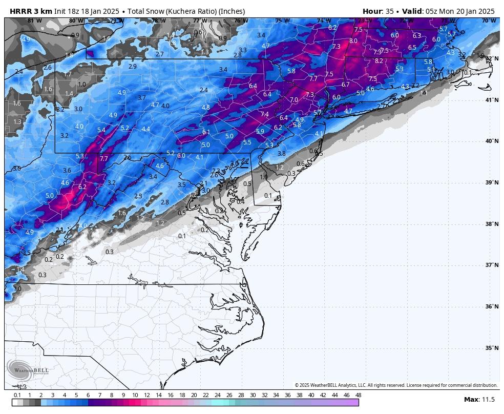
Along with cold weather, a potential shortwave is expected to cross the region Tuesday afternoon and increase the threat of hazardous travel due to snow. Snowfall amounts are expected to stay below Advisory criteria (likely 0.5 to 1.0 inches in isolated areas; a trace to 0.5 elsewhere). However, brief periods of low visibility from heavy snow can`t be ruled out. The 0-3km CAPE values range from 25J/kg to 50J/kg along the trough axis. Hi-Res guidance also has some noted potential stronger bands (reflectivity on the radar could measure 20DBZ to 30DBZ at times) between 3pm to 6pm (including Pittsburgh). If models remain consistent with this potential outcome, short- fused special weather statements and/or snow squall warnings may be needed to highlight the threat.-
1
-
-
8 hours ago, RitualOfTheTrout said:
Ugh.. as expected completely fizzled before making it to westmoreland.

Well this didn't age well, may have missed that specific band, but made up for it between 11pm last night and now. When I left the house at 4:45 I had 2 fresh inches since 11pm and that heavier band was about to pivot through which I ended up driving through, heavy snow and 12 degrees, cars sliding all over on 28 pretty crazy, then when I got to the city clear as a bell until I hit another band.
Late save by the lakes on this one. Looks like flow is rapidly shifting westerly so the fetches will get cutoff shortly but the arctic air will be spilling in. Wondering if this may be our last bout of LES assist as this incoming airmass should finish icing Erie over and start building up quickly on the others.
-
Getting some intermittent light to occasionally moderate bursts as what's left of that band finally made it. Much higher ratio / better flake structure than any point today. Should add another half inch or so.
Too bad the arctic front is coming through at 3am, could be fun, although Ill be up for work at 430, roads will probably be dicey.
The current 00Z sounding alludes the the heavily anticipated arctic frontal passing overnight tonight, with a tropopause of 500mb with dry stratospheric air above that. An adiabatic, nearly saturated layer is observed from the surface to roughly 800mb, which has been responsible for the convective snow during the early overnight hours tonight. The forcing for snow has mostly been the stark surface convergence as the cold air bullies is way in along the front. The frontal passage will cross tonight, leading to dramatic drops in temperatures. The most likely passage time will be roughly 9pm for Zanesville, 1am for Wheeling, 3am for Pittsburgh and Morgantown, 5am for Latrobe, and 7am for DuBois. Flow is expected to be progressive enough to result in minimal totals. Less than 1" of additional snow may be possible along the front on in dry, fluffy, high- ratio convective snow. Visibility may drop as low as 1/2 mi, but even lower visibilities are possible in blowing snow. Observations in Ohio indicate winds gusting as high as 20mph to 30mph along and behind the frontal passage. Webcams show snow-covered roads. -
Ugh.. as expected completely fizzled before making it to westmoreland.
-
30 minutes ago, Ahoff said:
Looks like a little Squallish weather to move in.
Hope that band holds together and moves east spending some time over my yard. Looks like it originated off Huron, but may be losing its link as the winds shift. Not super confident it makes it here.
-
43 minutes ago, blackngoldrules said:
I'm on the back edge of it in the South Hills now but it looks like there's some backfilling so maybe we'll get a little more?
Sent from my SM-G991U using Tapatalk
Looks like more light snow should develop as the afternoon progresses. Somewhere between a quarter to half an inch so far.
-
Well if radar trends hold it looks like models are going to nail the cutoff pretty well. If we were on the SE edge praying for a hold you know what would have happened.

-
1
-
-
3 hours ago, Rd9108 said:
Ehh looks like we most likely will get a inch maybe two at most. Oh well, just keep padding the stats.
Thats where I'm at, 1-2.
Other than helping this Jan with below average for the record books the lack of a decent storm preceding or much if any snow during I'm already sort of looking forward to moderating by next weekend.
Usually a true arctic airmass like what is coming has squalls or something when it goes through but not seeing anything like that.
-
9 minutes ago, Rd9108 said:
Fwiw HRRR. Just need to freshen up our snow pack.
That would be nice, Euro and GFS have us right on the fringe. Another 50 mile NW shift on those two would put most of us into a 2-4 range. This time there isn't a giant vortex or Northern stream interference so maybe we get a continued subtle trend north as we close in.
-
Sleet and zr here currently. Light glaze on the car, pavement seems fine. Expect it will be pretty short lived before plain rain takes over.
-
2 hours ago, Rd9108 said:
Well going to take my christmas lights down, but the RGEM held serve for the most part and now the ICON moved west and showed us getting 3 or 4. Very interesting.
Canadian models owe us something after all the headfakes showing a big storm over the years only to cave to the no snow models. Time to pay the bill and score a coop maybe? Lol
-
2
-
-
2 hours ago, Rd9108 said:
Not even bothering posting the RGEM but it shows the arctic wave forming further west and more amped than most guidance which gives us 6+. Hard to entertain it whenever other guidance is further east. Something to watch in the coming days.
Keeping an eye on Saturday, NAM looked a little thumpy before mix. I hope we can hold onto the pack through the arctic outbreak just to keep snow otg streak going. Getting another inch or two before we warm up enough for rain / mix would go a long way to helping with that.
-
City looks to get raked, just in time for rush hour.


Pittsburgh/Western PA Winter 2024-2025 Thread
in Upstate New York/Pennsylvania
Posted
Haha, Awesome. WeatherStar 4000+ Emulator?