
allgame830
-
Posts
2,528 -
Joined
-
Last visited
Content Type
Profiles
Blogs
Forums
American Weather
Media Demo
Store
Gallery
Everything posted by allgame830
-
 Do you think this one could defy the odds?
 -
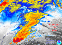
That is some nice 700 fronto right there!
-
I highly doubt that. Thursday is not moisture laden
-
Question: could we sacrifice Tuesday storm to keep going south which would help Wednesday/Thursday go further south or no?
-
Question: could we sacrifice Tuesday storm to keep going south which would help Wednesday/Thursday go further south or no?
-
So the Wednesday into Thursday event maybe doesn’t go to rain? I thought it seemed like it was
-
It was mostly sleet before now dumping snow again
-
I haven’t heard it and I have my deck door open drinking a nice cold beer and smoking
-
It’s ripping here neighbor
-
Yeah I think all these sleet reports are because it’s soo light barely anything or nothing on radar. Wait 30 minutes. Light sleet here as well
-
You can already start to see that now with the moisture over the past few hours exploding in OH and PA with the leading edge almost to state college

