allgame830
-
Posts
2,539 -
Joined
-
Last visited
Content Type
Profiles
Blogs
Forums
American Weather
Media Demo
Store
Gallery
Everything posted by allgame830
-

2/13 Significant/Major Winter Storm Discussion & Observations
allgame830 replied to Northof78's topic in New York City Metro
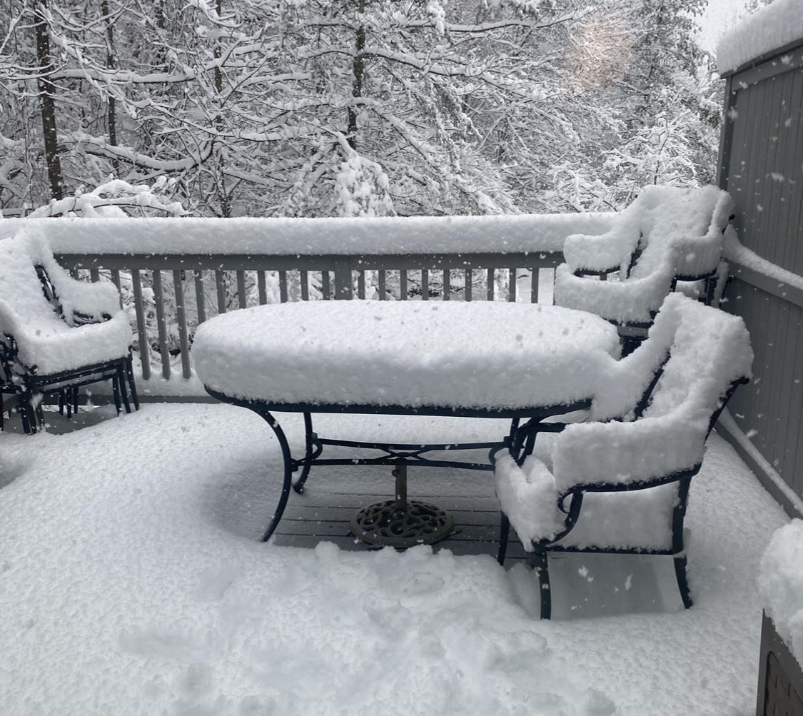
Looks exactly like my deck lol -
2/13 Significant/Major Winter Storm Discussion & Observations
allgame830 replied to Northof78's topic in New York City Metro
8”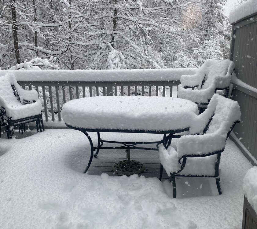
-
2/13 Significant/Major Winter Storm Discussion & Observations
allgame830 replied to Northof78's topic in New York City Metro
He doesn’t post during snowstorms -
2/13 Significant/Major Winter Storm Discussion & Observations
allgame830 replied to Northof78's topic in New York City Metro
Where are you located? 8” Thornwood NY -
2/13 Significant/Major Winter Storm Discussion & Observations
allgame830 replied to Northof78's topic in New York City Metro
Seems to be pretty accurate been around 2mb every 2 hours -
2/13 Significant/Major Winter Storm Discussion & Observations
allgame830 replied to Northof78's topic in New York City Metro
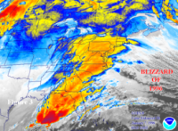
https://www.spc.noaa.gov/exper/mesoanalysis/new/viewsector.php?sector=17&parm=pmsl&underlay=1&source=1# down to 996 -
2/13 Significant/Major Winter Storm Discussion & Observations
allgame830 replied to Northof78's topic in New York City Metro
Just an FYI instead of the one liners maybe show a map or something. Thanks -
2/13 Significant/Major Winter Storm Discussion & Observations
allgame830 replied to Northof78's topic in New York City Metro
Now this would be great if it verified -
Stupid question maybe but isn’t that missing 2 hours of QPF?
-
2/13 Significant/Major Winter Storm Discussion & Observations
allgame830 replied to Northof78's topic in New York City Metro
Map plz? -
2/13 Significant/Major Winter Storm Discussion & Observations
allgame830 replied to Northof78's topic in New York City Metro
34/28 now. So whatever falls I guess it’s guaranteed to be snow at least. -
2/13 Significant/Major Winter Storm Discussion & Observations
allgame830 replied to Northof78's topic in New York City Metro
36/29 now. Btw are we using this thread for OBS as well? -
2/13 Significant/Major Winter Storm Discussion & Observations
allgame830 replied to Northof78's topic in New York City Metro
Temp down to 37 DP dropped to 29. Definitely did not get as warm as it was supposed to today. -
2/13 Significant/Major Winter Storm Discussion & Observations
allgame830 replied to Northof78's topic in New York City Metro
I truly believe we see a shift back north at 0z… how much idk -
2/13 Significant/Major Winter Storm Discussion & Observations
allgame830 replied to Northof78's topic in New York City Metro
21z RAP coming in with a solid bump NW so far through 12 hours compared to 20z. per NE Forum -
2/13 Significant/Major Winter Storm Discussion & Observations
allgame830 replied to Northof78's topic in New York City Metro
Are you at your daily limit yet for posting???? Models more often then not over adjust when south rather than north. -
2/13 Significant/Major Winter Storm Discussion & Observations
allgame830 replied to Northof78's topic in New York City Metro
In all fairness the last school closing the forecast was 2-4/3-6 so why wouldn’t they close this time. I understand your point. -
2/13 Significant/Major Winter Storm Discussion & Observations
allgame830 replied to Northof78's topic in New York City Metro
I do believe we see a tick back north for the 0z runs…. The new RAP ticked slightly north and the newest HRRR held serve -
2/13 Significant/Major Winter Storm Discussion & Observations
allgame830 replied to Northof78's topic in New York City Metro
I never said anything about 12+…. 6-12 in the JP zone which will be 30 miles north and south of NYC -
2/13 Significant/Major Winter Storm Discussion & Observations
allgame830 replied to Northof78's topic in New York City Metro
Yeah I think like I said before north of 84 is iffy right now 2-4/3-6…. But Northern Westchester/Putnam south will be just fine here. Biggest of the year -
2/13 Significant/Major Winter Storm Discussion & Observations
allgame830 replied to Northof78's topic in New York City Metro
Ok boss! Check back tomorrow. Never said it’s totally accurate but this over excessive with ahhh the models are showing too much blah blah…. Look at the damn radar and compare which I see none of that! All speculation and guessing from you. -
2/13 Significant/Major Winter Storm Discussion & Observations
allgame830 replied to Northof78's topic in New York City Metro
Oh ok gotcha! “Rolling my eyes”…… -
2/13 Significant/Major Winter Storm Discussion & Observations
allgame830 replied to Northof78's topic in New York City Metro
Fair enough…. But it’s still 6-12+ area wide -
2/13 Significant/Major Winter Storm Discussion & Observations
allgame830 replied to Northof78's topic in New York City Metro
Sooo what’s with all the complaining LOL…. Snow starts in like 12 hours NOT 3 days -
2/13 Significant/Major Winter Storm Discussion & Observations
allgame830 replied to Northof78's topic in New York City Metro
Weaker??? 12z runs showed just above 3 of them all sub 990…