

mob1
-
Posts
2,222 -
Joined
-
Last visited
Content Type
Profiles
Blogs
Forums
American Weather
Media Demo
Store
Gallery
Posts posted by mob1
-
-
2 minutes ago, jacindc said:
Slidell PD spokesman on WWL saying that this is far worse than anyone anticipated. And the live shot is showing some pretty bad conditions.
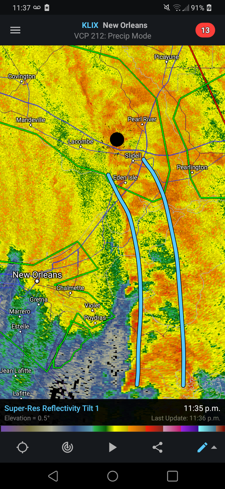
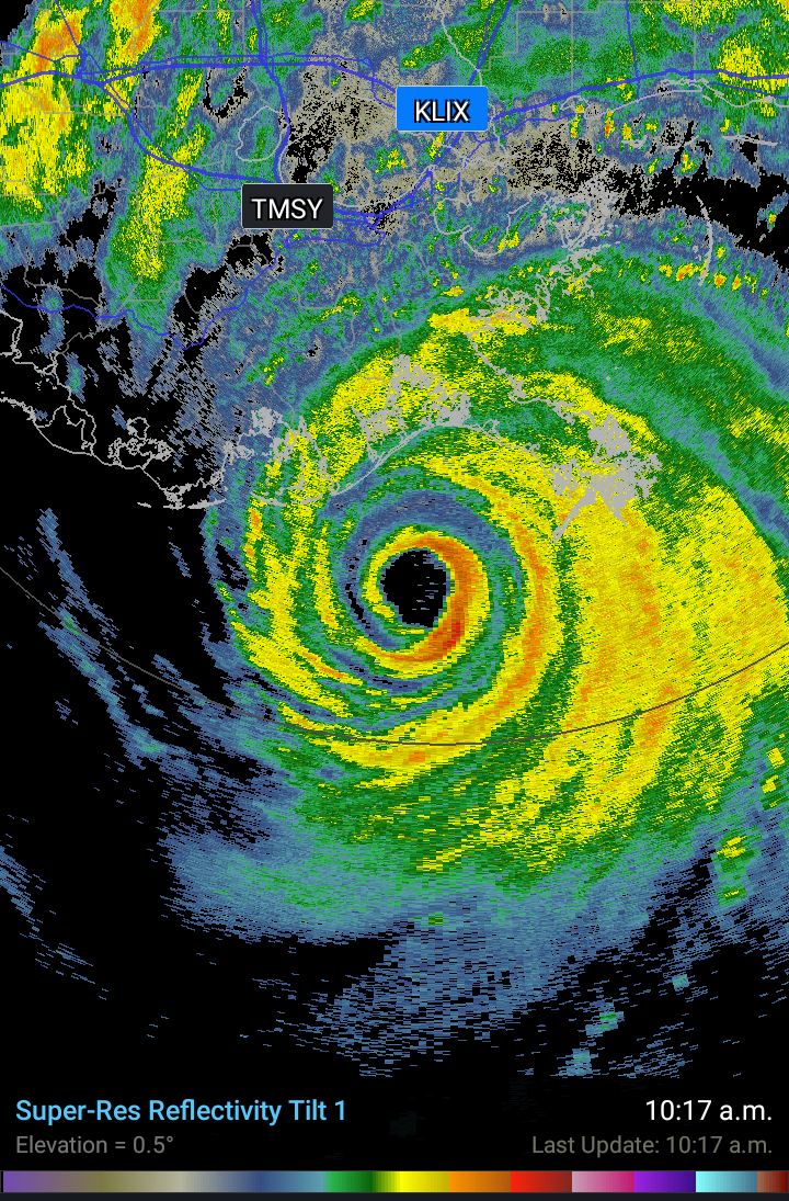
Intense feeder bands have been training over that general area for hours, and will probably continue doing so for a while. Sames goes for areas getting the eastern eyewall (like Hammond), the flash flooding will ultimately turn into significant river flooding for some areas.
-
 1
1
-
-
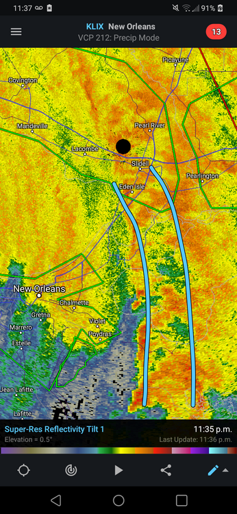
Flooding could also be very bad for areas who have feeder bands training over them all night. Slidell LA for example.
-
-
This thread is absolutely morbid, in an hilarious way.
-
1
-
-
The radar returns near Laplace is getting ridiculous, they've been getting absolutely pummeled for hours on end.
-
1
-
-
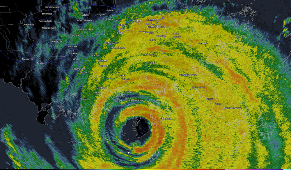
939 mb pressure reading in Lockport, which is fairly far inland. Very impressive.
-
5
-
-
New Orleans Lakefront airport gusting to 82 mph now.
-
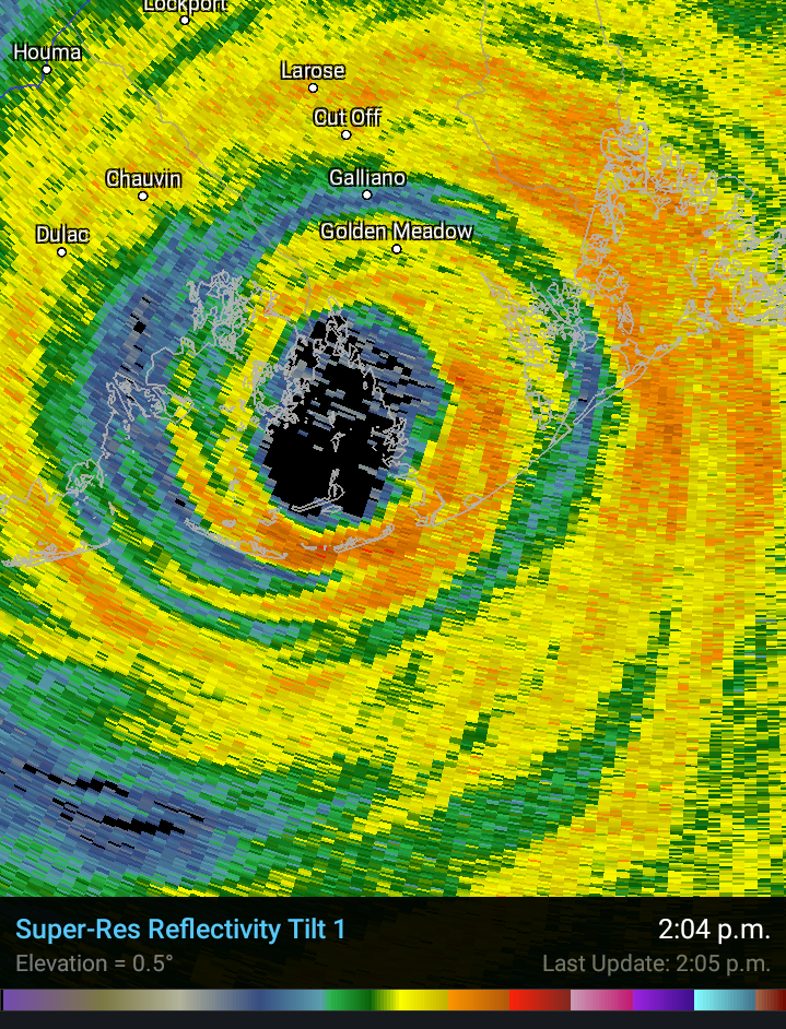
Golden Meadow. Looks rough
-
3
-
-
Holding it's own

-
3
-
-
Golden Meadow is about to take it on the chin, Mark Sudduth set up a camera there as well.
-
Those towns are about to be rocked by a still healthy northern eyewall.
-
1
-
-
Just now, jojo762 said:
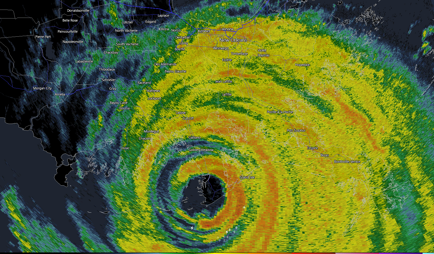
And they likely missed the strongest winds as the inner core is passing just west of them.
-
Inner eyewall is recovering a bit, even as the moat is still very pronounced.
-
3 minutes ago, STxVortex said:
Could you clarify that? AF303 is progressing back to KSKF. But AF302 was outbound and getting close to Ida, but the data stopped about 25 minutes ago, 0655utc [on Levi's feed]. So has AF302 been aborted?
Unfortunately yes
-
1
-
-
6 minutes ago, MattPetrulli said:
105 knt SFMR in NW eyewall too.
Big increase there from first pass, the windfield is fairly large now.
-
1 minute ago, WEATHER53 said:
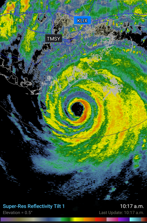
Best hope now for NO is it pushes further east and get out of ne quad
Very unlikely at this point
-
1
-
-
6 minutes ago, allgame830 said:
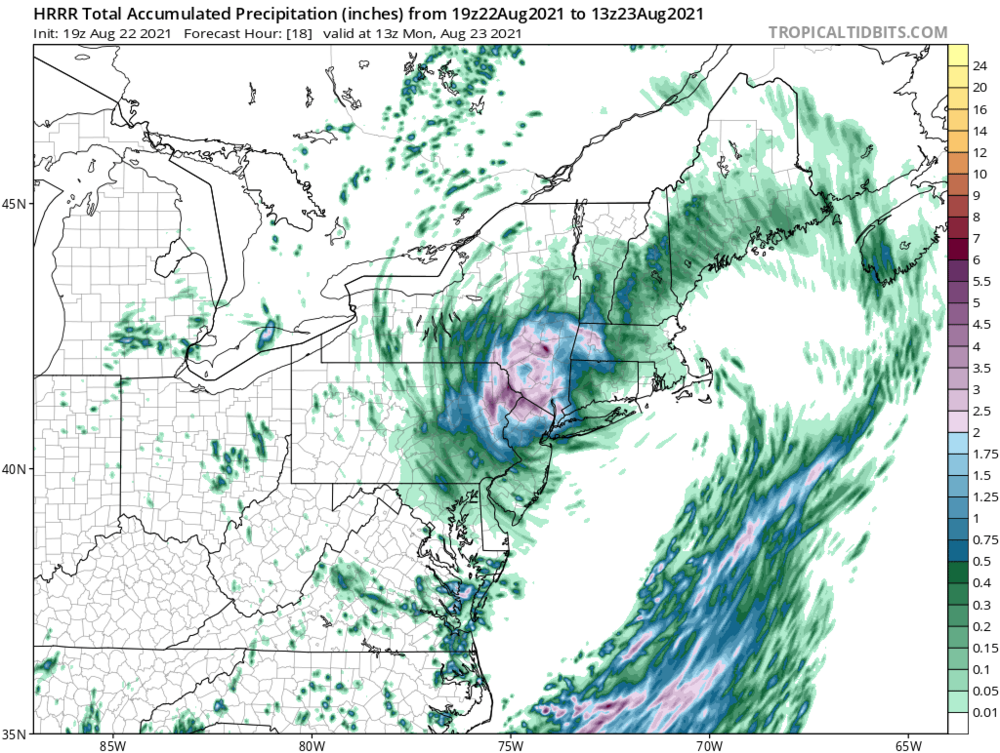
Plz post HRRR?
-
Just now, sojitodd said:
How about now?
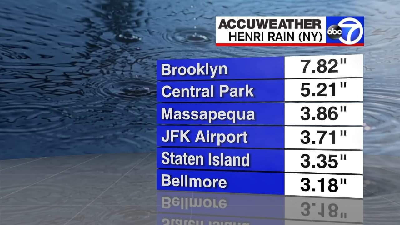
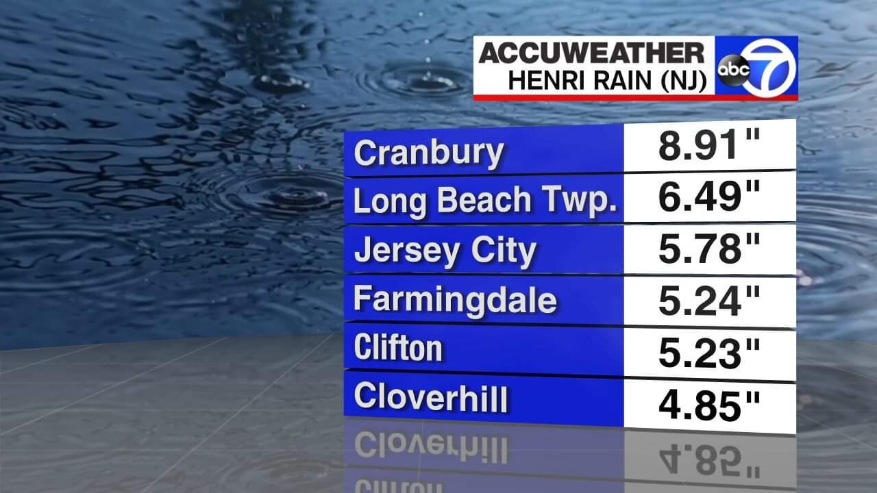
The rain just seems to be converging on NYC. And it looks heavy too.
Don't see anything on Twitter but it's possible some areas are seeing localized flooding. Areas in NJ will probably have some river flooding soon, especially if those insane totals the HRRR depicts for tonight pan out.
-
9 minutes ago, BxEngine said:
Just like winter, its fun reading back through the thread of the people who are too cool to believe certain models and “there is no way we’ll see even remotely close To those totals”.
still time for someone in the metro to get to double digits.

Very impressive. Models still have a ton of rain for far northern NJ tonight, I wouldn't be surprised if some of the higher totals end up coming from that area or the LHV.
-
Just now, dmillz25 said:
I live near by there and that flooding was crazy
I was a few miles south of there and the rainfall was easily the most intense I've ever seen. Every staircase looked like a waterfall. Out here in SI I got somewhat less rain and am closing in on 5 inches.
-
 1
1
-
-
6 minutes ago, RippleEffect said:
Any flooding going on in the city?
Nothing today. Given the flat terrain and lack of rivers that flood, NYC generally only floods with very heavy rates that produce flash flooding. Hours of light to moderate rain won't do anything.
-
2
-
-
While wind and surge will likely be confined to eastern LI, we could have a formidable flooding event for other parts of the area. Slow moving tropical systems are trouble, we just need to hone in to where the heaviest rains will set up.
-
4
-
1
-
-
Just now, radarman said:
Seems like 16" was the max in Diane in CT. That would qualify as easily. Only the state's biggest flood ever.
I think Westfield MA got close to 20 inches of rain.
-
1
-
-
Just now, dan11295 said:
How much moisture will Henri have, would think the slow movement could be very problematic re: flooding
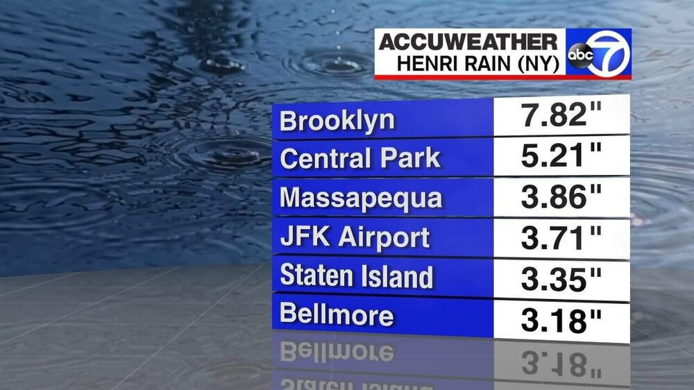
While people like to hype the wind and surge aspect, for a decaying slow moving storm that's relatively small in size, flooding is by far the biggest potential issue.
-
6
-


Major Hurricane Ida
in Tropical Headquarters
Posted
They are in the easternmost area of the state, and weren't really expecting much.