

DomNH
-
Posts
7,811 -
Joined
-
Last visited
Content Type
Profiles
Blogs
Forums
American Weather
Media Demo
Store
Gallery
Posts posted by DomNH
-
-
Absolutely dumping. There is going to be a lot of Phil in SNH. Eversource map is lit up in western Hillsborough and Cheshire and it looks like it's just starting to spread east.
-
 1
1
-
-
Puking cement. Looks like 2-3’’ down already.
-
4 minutes ago, 40/70 Benchmark said:
This season would be probably once in a lifetime for me for so little snow return on such strong episodes of blocking.
Super borderline in the BL looking at the soundings but def looks like a pretty epic paste bomb from late morning through the afternoon even in your hood verbatim.
-
1
-
-
Maybe slightly ambitious but I’ll go 10-15’’ final here. I’ve seen enough to think we cash in on some insane rates tomorrow.
-
2
-
-
Lol at the 3’’+ QPF max in Eastern MA on the NAM.
-
Euro more or less run out of my basement.
-
8
-
-
Just now, Sey-Mour Snow said:
That was the worst model of all time. Just couldn’t think of the name.
Don't disrespect the DGEX like that.
-
 4
4
-
-
1 minute ago, dendrite said:
We rap

I don't mind pounding a foot of paste, slotting, and wind.
-
1
-
-
6 minutes ago, 40/70 Benchmark said:
Sucks here.
I thought it looked good.
-
3
-
-
16 minutes ago, Chrisrotary12 said:
Over/under 10" here.
I'm thinking right around a foot give or take so over but not wildly over.
-
1 minute ago, 40/70 Benchmark said:
The 06z euro actually trended a tic colder here at H925 warmest point, which is what I would expect with even heavier rates of precipitation. Unless the model is wrong, I am getting over 1 foor of snow. Even the positive depth map has me at a foot...that is a very reasonable floor.

That's the 18z Euro not the 0z euro on the right but I agree with your overall point. My thought when I looked at the 6z this morning was also that it's an absolute crushing in the sense that it's just puking cement but if we're defining crushing as highest totals obviously elevated spots favored.
-
Looking more and more like 10-15'' or so up here than the 6-12'' I was thinking yesterday. We

-
1
-
1
-
-
1 minute ago, NorEastermass128 said:
With the winds, it will only take a few inches of paste to start hearing snaps.
Been wondering the opposite - if the wind will actually help knock the snow off the trees/lines rather than help bringing them down. Maybe not so much at the coast but at least inland where the snow might be slightly less wet and the winds less impressive.
-
3
-
-
17 minutes ago, STILL N OF PIKE said:
Ray crusher?
Crushes us.
-
1
-
-
Good lord is the 6z GFS a townhouse toppler up here. Still not super confident in anything but damn this might be a big one up here after all.
-
2
-
-
3 minutes ago, Chris12WX said:
Do we get over 6.2”? Biggest of season.
Might be trending to a full blown condo collapser. Tough one.
-
1
-
-
Right after I say 6-12'' absolutely smoked on both the GFS and Euro. Ugh.
-
1
-
-
Gun to head I’d go 6-12’’ here. Big boy totals in the usual favored elevation spots. Going to need consistently epic rates to score 12’’+ in the lowlands and I’m not confident in that yet. Any 1-2sm subby zone stuff isn’t going to accumulate for shit.
-
3
-
-
27 minutes ago, STILL N OF PIKE said:
Merrimack valley ...I.E ash is boned ..I.e where he lives
I am all in on the spring train so I don't really care but that's a tough look for the MV and central CT. Plus I think there would be a lot of localized subsidence screw zones in that scenario.
-
1
-
-
Sarah McLachlan ringing throughout certain areas of SNE if we get something like that GFS solution.
-
1
-
-
Flakes are pretty crap even in this band. Dry air FTL AWT.
-
33 minutes ago, weatherwiz said:
This is going to be brutally ugly I think. I'd still be extremely skeptical with these QPF outputs, especially on such a widespread level.
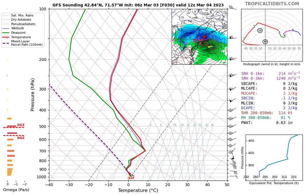
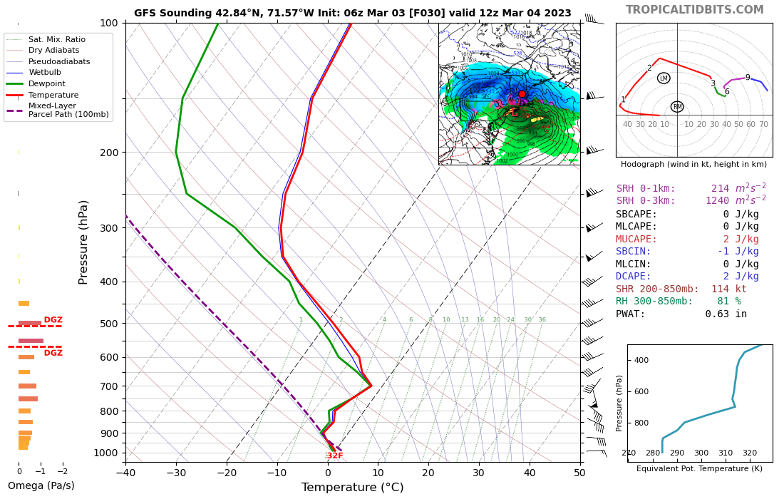
Soundings look like shit too. This is 06z GFS for 12z tomorrow here. Bone dry in the DGZ. I'm guessing we're getting at a shredded radar look plus crap snow growth. We'll see what the mesos do but I'm thinking there will be a lot of disappointed weenies tomorrow with 3-5'' of sand then a slot and 33F by 10 am.
-
GFS will just not let go of that afternoon CCB.
-
38 minutes ago, mahk_webstah said:
Define we
You won’t have the same BL issues but it is still going to dry out in the morning. If the thump fails this is a total bust.

Last Hurrah Obs Thread: 3/13-15/23
in New England
Posted
Went to moderate for a bit but now absolutely puking again. Looks like 4'' or so. HRRR really goes to town later on.