

Roger Smith
-
Posts
4,972 -
Joined
-
Last visited
Content Type
Profiles
Blogs
Forums
American Weather
Media Demo
Store
Gallery
Posts posted by Roger Smith
-
-
Don and/or bluewave can confirm exact details, but I believe 2023 will surprass previous contenders for warmest year at NYC (2012 and 2020 were close to being tied at 57.3 F), as long as it remains above 1991-2020 normal value. As latest projections are close to +3 anomaly for Dec, 2023 would average close to 57.5 or even 57.6. January set a pace and despite one or two cooler months like Nov, it will become new top of the heap.
-
 2
2
-
-
18z GFS ends (on Jan 4 2024) with a setup that looks like the next 36h of its run would turn into a large east coast winter storm, about like it was doing ten days ago for Dec 26-27 (which has degraded into the double rainer scenario). The difference could be that a lot more cold air is in place for this fantasy output. A long slow slide into deep winter is what I would expect and Dec will not be repeated in Jan or early Feb. Later Feb, possibly back to torch, but after a reasonable stretch of winter.
DOUBLE RAINER
DEUBLE DAINER
DEBBLE DOINER
DEBBIE DOWNER
(fun with words)
-
 1
1
-
-
Top 20 Dec mild to Jan cold at NYC
_ for inclusion in list, Dec >37.0 F __ >0.6 above LTA
_ median drop is 4.4 F, over 155 years, from 36.4 to 32.0 F
_ average of cases below is a drop from 40.9 to 29.7 F (+4.3 to -2.3)
_ a few winters saw drops in same range, but Dec was below 37.0F
Rank ____ Dec ______ Jan _______ diff
_01 ____2015 50.8 _ 2016 34.5 __ -16.3
_02 ____ 1911 39.4 _ 1912 23.7 __ -15.7
_03 ____1984 43.8 _ 1985 28.8 __ -15.0
_04 ____2021 43.8 _ 2022 30.3 __ -13.5
_05 ____2003 37.6 _ 2004 24.7 __ -12.9
_06____1956 40.9 _ 1957 28.5 __ -12.4
_07 ____1993 37.3 _ 1994 25.6 __ -11.7
_08 ____1967 38.2 _ 1968 26.7 __ -11.5
_09 ____1891 42.3 _ 1892 31.5 __ -10.8
_10 ____1881 39.4 _ 1882 28.8 __ -10.6
_11 ____1953 41.3 _ 1954 30.8 __ -10.5
_12 ____2008 38.1 _ 2009 27.9 __ -10.2
_13 ____1987 39.5 _ 1988 29.5 __ -10.0
_14 ____2013 38.5 _ 2014 28.6 ___ -9.9
_15t____1923 42.0 _ 1924 32.7 ___ -9.3
_15t____1998 43.2 _ 1999 33.9 ___ -9.3
_17 ____ 1996 41.3 _ 1997 32.2 ___ -9.1
_18 ____ 1999 40.0 _ 2000 31.3 __ -8.7
_19t____1957 40.2 _ 1958 31.9 ___ -8.3
_19t____1965 40.5 _ 1966 32.2 ___ -8.3
_19t____1982 42.8 _ 1983 34.5 ___ -8.3
Recent cases considered marginal include:
_xx ____2018 40.1 _ 2019 32.5 ___ -7.6
(_xx ____2004 38.4 _ 2005 31.3 ___ -7.1)
(_xx ____2012 41.5 _ 2013 35.1 ____ -6.4)
At least we can conclude large drops in Dec to Jan are not unusual.
-
 1
1
-
-
This storm finishes just outside top ten for December for both 1-day and 2-day precip totals. ...
As of now, lists are updated as follows:
Top 15 December precip at NYC over 1 day (snowfall included, gives a measure of QPF) and top 25 to last year's Dec 22-23 event includes eventual 2-day for all one-day events listed.
20" snow Dec 26-27 2010 yielded 1.61" liquid equivalent.
Note top two on list are both on Dec 13. Ranks 6 and 8 are on Dec 11.
(added Dec 17-18 2023) _ current ranks 12 and 13
Rank ___ 1-day ___ Date _________ (snow if any) _____ max, min temps (F)
_01 ____ 3.09 _____ Dec 13, 1909 (1.0" snow) _____ 53, 33
_02 ____ 2.97 _____ Dec 13, 1941 (0.3" snow) _____ 46, 27
_03 ____ 2.54 _____ Dec 9, 2014 (1.0" snow 10th) _ 42, 36
_04 ____ 2.52 _____ Dec 29, 1901^_________________ 55, 44
_05 ____ 2.49 _____ Dec 21, 1973 (Tr snow) _______ 57, 25 (Dec 20-21 o/n warm)
_06 ____ 2.41 _____ Dec 11, 1992 __________________ 42,37
_07 ____ 2.36 _____ Dec 26, 1947 (26.4" snow) ___ 31, 25
_08 ____ 2.35 _____ Dec 11, 2008 _________________ 43, 37
_09 ____ 2.28 _____ Dec 17, 1888 _________________ 55, 50
_10 ____ 2.25 _____ Dec 16, 1974 __________________47, 38
_11 ____ 2.22 _____ Dec 14, 1897 __________________ 53, 45
_12 ____ 2.21 _____ Dec 18, 2023 __________________ 62, 42
_13 ____ 2.19 _____ Dec 9, 1973 ___________________ 55, 37
_14 ____ 2.18 _____ Dec 22, 1983 (0.6" snow) _____ 53, 31
_15 ____ 2.16 _____ Dec 2, 1974 ___________________ 50, 39
_16 ____ 1.98 _____ Dec 7, 1908 ___________________ 57, 38
(next top contender large snowfall was Dec 20, 1874, 1.92 incl 10.0" snow)
(Dec 26-27 2010 20" snow reduced to 1.61" precip)
Rank ___2-day ____Dates _______________________ Temps
_01 ____ 3.62 ____ Dec 12-13, 1983 ______________ temps in 53-59 range for rainfall portion
_02 ____ 3.29 ____ Dec 13-14, 1909 (1.0" snow) __ 53, 33 and 53, 40
_03 ____ 3.28 ____ Dec 11-12, 2008 ______________ 43, 37 and 44, 32
_04 ____ 3.03 ____ Dec 13-14, 1941 ______________ 46, 27 and 46, 33
_05 ____ 2.96 ____ Dec 29-30, 1901 ______________ 55, 44 and 45, 34
_06*____ 2.94 ____ Dec 30-31, 1948 (4.0" snow)__57, 52 and 52, 25
_07 ____ 2.87 ____ Dec 11-12, 1992** (0.4" snow)_42, 37 and 43, 32
_08*____ 2.73 ____ Dec 2-3, 1986 ________________ 53, 35 and 59, 46
_09 ____ 2.65 ____ Dec 20-21, 1973 (Tr snow) ____54, 25 and 57, 25 (Dec 20-21 o/n warm)
_10 ____ 2.62 ____ Dec 9-10, 2014 (1.0" snow) ___ 42, 36 and 40, 32
_11*____ 2.61 ____ Dec 6-7, 1996 (Tr snow) _______46, 35 and 45, 34
_12 ____ 2.58 ____ Dec 1-2 1974^ _(Tr snow) _____ 42, 33 and 50, 39
_13 ____ 2.47 ____ Dec 17-18, 2023 ______________ 59, 47 and 62, 42
_14 ____ 2.40 ____ Dec 26-27, 1947 (26.4" snow) _31, 25 and 35, 29
_15*____ 2.36 ____ Dec 14-15, 1981 (1.4" snow) __ 37, 29 and 38, 35
_16 ____ 2.33 ____ Dec 17-18, 1888 _______________55, 50 and 52, 29
_17 ____ 2.28 _____ Dec 14-15, 1897 ______________53, 45 and 57, 47
_18*____ 2.25 _____ Dec 9-10, 1878 (0.5" snow) __46, 33 and 60, 46
_19*____ 2.24 _____ Dec 7-8, 1914 (0.5" snow) ___ 36, 32 and 36, 30 (presumably a lot of snow not far away)
_20 ____ 2.21 _____ Dec 22-23, 1983 (0.8" snow) _ 53, 31 and 41, 22 (6, 4 next 2d min)
_21 ____(2.19" Dec 9 1973 no additional amounts Dec 8 or 10)
_22 ____ 2.13 _____ Dec 3-4, 1925 _______________ 49, 39 and 51, 46
_23 ____ 2.08 _____Dec 19-20, 1936 (Tr snow) ___48, 23 and 55, 34
_24 ____2.06 _____ Dec 22-23, 2022 (Tr snow) __47, 35 and 58, 8 (max 15 min 7 on Dec 24)
_25 ____2.03 _____ Dec 6-7, 1908 _______________ 43, 26 and 57, 38
* (to rank 21, all 2-day contenders except ranks 6, 8, 11, 15, 18 and 19 are also in one-day table. Rank 6 is 1.54" + 1.40" ... Rank 8 is 1.62"+1.11" ... Rank 11 is 1.20"+1.41" ... Rank 15 is 1.02" + 1.34" ... Rank 18 is 0.63"+1.62" ... Rank 19 is (0.25"+)1.81"+0.43")
note, a 3rd significant Dec-1983 value of 1.97" for Dec 3-4, 1983.
** 3.31" total Dec 10-12 1992 ... 2.85 Dec 10-11 1992 2-day is not counted as separate entry but ranks 8, if all cases are considered. Same applies to 2.62" Dec 10-11, 2008.
2.95" fell Dec 28-30 1942 but Dec 29 value of 0.39" (1.22+0.39+1.34) _ no qualifying 2-d totals.
___________________________________________
-
Partial dry slot developing but southern energy will be pulled in across NYC and w LI this afternoon, expect another 0.50" to 0.75" rain with that, winds will also pick up again to SW 40-55 in exposed areas. Squall line in w/c Long Island appears headed for central CT and will be focus of svr trw developing later in parts of e/c NE.
Double centered for now but will consolidate into one low over period 15z to 21z.
-
I notice numerous reports of intense TRW activity over central Long Island (in NYC forum) and it appears to be racing north into CT, with an associated warm front also looking active, would expect widespread TRW soon in large portions of sNE.
Low developed twin centers but is now consolidating and southern energy off Delmarva will be pulled into primary during afternoon. Could be some extreme obs posted, "marginal" svr wx now posted could be more like enhanced.
-
Actually surprised this did not get a name (Vince), have seen less impressive storms named in season. Took four months to get a TS designation on Atlantic January storm, so maybe same lag with (eventual) Vince.
Can see basis for dispute over wind speeds, but given the nearly STS nature of almost - Vince, I would be very reluctant to downgrade wind speeds based on global model isobars alone. All day long there have been gusts over 65mph ahead of developing southern center (it is going twin-centered o/n). West of CT River and central LI, I can see a good argument for reducing wind gust forecasts, at least beyond 15z. East of that I would go with Kev's estimates or at least an average of Kev and 007. Gradient actually increases later in day for maine, New hampshire.
Would expect svr wx potential e CT, n RI and parts of se ma towards 18z, even slgt tor risk.
Given severe component, some location will gust to 80-100 mph but at airport wx stations? It will likely be some place without official measurements but verifiable based on wind damage.
-
60 kt gusts are now as far north as Diamond Shoals off Cape hatteras. (60 kt = 67-68 mph)
-
Double centered structure indicated on GFS would cut off stronger winds after a brief interval late overnite, winds would only continue to be an issue about KISP-east after briefly affecting all regions.
Reggie is (a) overdone or (b) will nearly double existing Dec records.
-
 1
1
-
-
Anomalies and projections ...
_______________________________________ DCA _ NYC _ BOS __ ORD _ ATL _ IAH ____ DEN _ PHX _ SEA
(17) _________ (anom 16d) ____________ +1.8 _ +4.2 _ +3.3*__ +6.8 _ +3.8 _ +2.3 __ +5.1 _ +4.3 _ +2.7
____________ (p anom 31d) ____________+2.0 _ +3.0 _ +3.0 __ +4.0 _ +3.0 _ +2.0 __ +4.0 _ +3.5 _ +2.0
(23) _________ (anom 22d) ____________+1.9 _ +4.0 _ +3.7 __ +6.7 _ +1.7 _ +2.6 __ +7.8 _ +5.9 _ +2.6
____________ (p anom 31d) ____________+2.0 _ +3.0 _ +3.0 __ +5.0 _ +3.0 _ +2.5 __ +4.0 _ +3.5 _ +2.0
As speculated, some anomalies did get up pretty far, here is the end result ...
____________ (anom 31d) ______________+3.8 _ +5.5 _ +5.1 __ +8.6 _ +2.6 _ +1.9 __ +6.2 _ +4.7 _ +3.5
* BOS est as Dec 16 not incl (+11 blend w 2.9 1-15)
(17) _ Based projections on a continuation of trends, possibly not quite as anomalously warm as first part of Dec, but no big changes indicated.
Current projections would score only 80 _ 58 _ 54 __ 54 _ 60 _ 82 ___ 54 _ 50 _ 64 ___ 556
___ Consensus ________________+1.0 _+0.9 _+0.4 __+1.7 _+1.0 _+1.1 ___ +1.7 _+1.0 _+0.2
(warmer forecasts would score over 700).
wxallannj could close in on leader DonS, but I don't believe scoring potential is sufficient to overcome deficit; may be a close finish.
(23) _ Projections adjusted, preliminary scoring to be posted soon. ORD and IAH were bumped up and rest were as before, looks like a gradual shift to below normal temps near end of Dec, not very far below average anywhere as source regions have little snow cover.
(31-Jan 1) _ Scoring is being adjusted to final anomalies. (now final)
-
Frying Pan Shoals, off the coast near NC/SC border, recently reported 42 kts sustained gusting to 60 kts.
This probably should be STS Vince, it is definitely at strong tropical storm intensity at present time. Is it going by any name from TWC?
-
I will guess 2.5 to 3.0 in, risk of 3.5 in.
-
Before Dec 18 Event ... top 12 one-day and two-day rainfalls at NYC ... temps indicated also
Rank ___ 1-day ___ Date _________ (snow if any) _____ max, min temps (F)
_01 ____ 3.09 _____ Dec 13, 1909 (1.0" snow) _____ 53, 33
_02 ____ 2.97 _____ Dec 13, 1941 (0.3" snow) _____ 46, 27
_03 ____ 2.54 _____ Dec 9, 2014 (1.0" snow 10th) _ 42, 36
_04 ____ 2.52 _____ Dec 29, 1901^_________________ 55, 44
_05 ____ 2.49 _____ Dec 21, 1973 (Tr snow) _______ 57, 25 (Dec 20-21 o/n warm)
_06 ____ 2.41 _____ Dec 11, 1992 __________________ 42,37
_07 ____ 2.36 _____ Dec 26, 1947 (26.4" snow) ___ 31, 25
_08 ____ 2.35 _____ Dec 11, 2008 _________________ 43, 37
_09 ____ 2.28 _____ Dec 17, 1888 _________________ 55, 50
_10 ____ 2.25 _____ Dec 16, 1974 __________________47, 38
_11 ____ 2.22 _____ Dec 14, 1897 __________________ 53, 45
_12 ____ 2.19 _____ Dec 9, 1973 ___________________ 55, 37
_13 ____ 2.18 _____ Dec 22, 1983 (0.6" snow) _____ 53, 31
_14 ____ 2.16 _____ Dec 2, 1974 ___________________ 50, 39
_15 ____ 1.98 _____ Dec 7, 1908 ___________________ 57, 38
Rank ___2-day ____Dates _______________________ Temps
_01 ____ 3.62 ____ Dec 12-13, 1983 ______________ temps in 53-59 range for rainfall portion
_02 ____ 3.29 ____ Dec 13-14, 1909 (1.0" snow) __ 53, 33 and 53, 40
_03 ____ 3.28 ____ Dec 11-12, 2008 ______________ 43, 37 and 44, 32
_04 ____ 3.03 ____ Dec 13-14, 1941 ______________ 46, 27 and 46, 33
_05 ____ 2.96 ____ Dec 29-30, 1901 ______________ 55, 44 and 45, 34
_06*____ 2.94 ____ Dec 30-31, 1948 (4.0" snow)__57, 52 and 52, 25
_07 ____ 2.87 ____ Dec 11-12, 1992** (0.4" snow)_42, 37 and 43, 32
_08*____ 2.73 ____ Dec 2-3, 1986 ________________ 53, 35 and 59, 46
_09 ____ 2.65 ____ Dec 20-21, 1973 (Tr snow) ____54, 25 and 57, 25 (Dec 20-21 o/n warm)
_10 ____ 2.62 ____ Dec 9-10, 2014 (1.0" snow) ___ 42, 36 and 40, 32
_11*____ 2.61 ____ Dec 6-7, 1996 (Tr snow) _______46, 35 and 45, 34
_12 ____ 2.58 ____ Dec 1-2 1974^ _(Tr snow) _____ 42, 33 and 50, 39
_13 ____ 2.40 ____ Dec 26-27, 1947 (26.4" snow) _31, 25 and 35, 29
_14*____ 2.36 ____ Dec 14-15, 1981 (1.4" snow) __ 37, 29 and 38, 35
_15 ____ 2.33 ____ Dec 17-18, 1888 _______________55, 50 and 52, 29
_16 ____ 2.28 _____ Dec 14-15, 1897 ______________53, 45 and 57, 47
_17*____ 2.25 _____ Dec 9-10, 1878 (0.5" snow) __46, 33 and 60, 46
_18*____ 2.23 _____ Dec 7-8, 1914 (0.5" snow) ___ 36, 32 and 36, 30 (presumably a lot of snow not far away)
_19 ____ 2.21 _____ Dec 22-23, 1983 (0.8" snow) _ 53, 31 and 41, 22 (6, 4 next 2d min)
_20 ____(2.19" Dec 9 1973 no additional amounts Dec 8 or 10)
_21 ____ 2.13 _____ Dec 3-4, 1925 _______________ 49, 39 and 51, 46
_22 ____ 2.08 _____Dec 19-20, 1936 (Tr snow) ___48, 23 and 55, 34
_23 ____2.06 _____ Dec 22-23, 2022 (Tr snow) __47, 35 and 58, 8 (max 15 min 7 on Dec 24)
_24 ____2.03 _____ Dec 6-7, 1908 ________________43, 26 and 57, 38
* (to rank 20, all 2-day contenders except ranks 6, 8, 11, 14, 17 and 18 are also in one-day table. Rank 6 is 1.54" + 1.40" ... Rank 8 is 1.62"+1.11" ... Rank 11 is 1.20"+1.41" ... Rank 14 is 1.02" + 1.34" ... Rank 17 is 0.63"+1.62" ... Rank 18 is (0.25"+)1.81"+0.43")
note 3rd significant Dec-1983 value of 1.97" for Dec 3-4, 1983.
** 3.31" total Dec 10-12 1992 ... 2.85 Dec 10-11 1992 2-day is not counted as separate entry but ranks 8, if all cases are considered. Same applies to 2.62" Dec 10-11, 2008.
2.95" fell Dec 28-30 1942 but Dec 29 value of 0.39" (1.22+0.39+1.34) _ no qualifying 2-d totals.
___________________________________________
will add 2023 _ Dec 18 and 17-18 values to lists if qualifying.
-
Twin-centered low, would expect s component to cut off strong winds in NYC and w LI after first part of event. Inland NJ will see prolonged period of less windy or even calm conditions due to two-part train of lows (if verified). Rain could be under-done, 1909 one-day record is definitely on table at moment, timing is good for almost all rain to be on one calendar day (mon Dec 18).
-
1
-
-
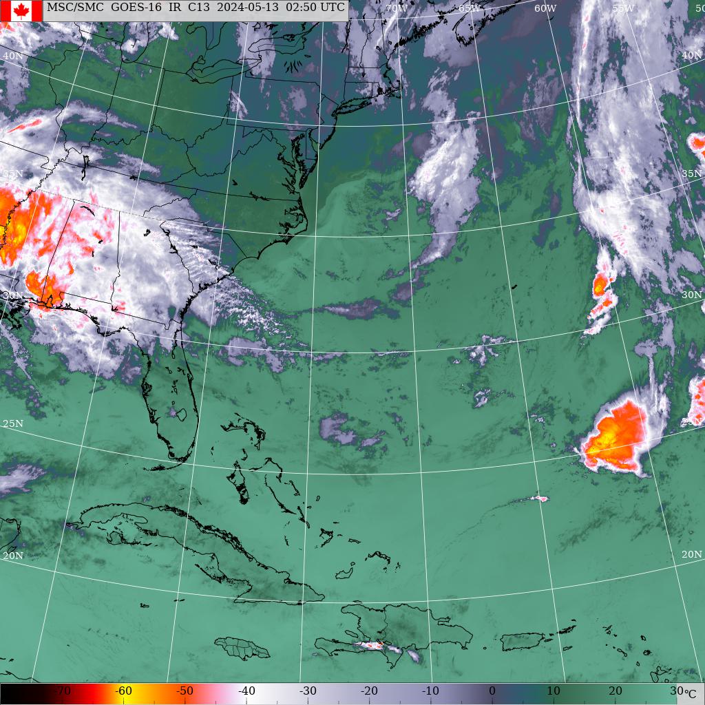
Almost-Vince rapidly developing in eastern Gulf. Note squall line feature in western Cuba, center is probably around 1005 mbs near 25N 85W. Will track across n FL and se GA, up coast just a bit inland at times, over DCA-BAL region late Sunday, n NJ by monday.
http://weather.gc.ca/data/satellite/goes_eusa_1070_100.jpg
Link will probably update to current time as you encounter it, so comments above apply to 21z imagery.
Currently over 78-80 F SST region, so legit tropical storm candidate, "almost" Vince could be Vince (bookend un-named tropical storms for 2023? -- one in January).
-
1
-
-
Fear the wrath of almost-Vince.
-
1
-
-
The sea was angry that day, my friends.
-
3
-
 4
4
-
-
Storm is about as close to being a tropical storm as a Dec east coast storm can be, I even think there is a chance of it being named (as a STS), but whether or not that happens, potential for one-day DEC rainfall record (3.09" at NYC) to be challenged. (2-d totals around 3.5" if arrival is overnight) ... Very windy on Long Island and southern New England, not so sure it will be windy inland NJ, possibly just along coast briefly. It's rather like blizzard of '93 without cold air available (for track and intensity).
Second event could be a figment of some models' imagination. It is way OTS on other guidance. A very good pattern is slowly developing by Dec 26, two possible winter storms but phasing with late-arriving cold air from Quebec rather than deep arctic air from central Canada, could be a negative for coast, would put money on heavy snowfalls in interior regions and perhaps mixing near coast with first of two (26-27), second one (29-30) looks more promising generally.
-
2
-
1
-
-
Season is probably done but maybe not, eastern Gulf storm looks almost tropical storm, and westward moving low in subtropics could be a stat padder (for me anyway).
-
If for any reason it cooled down on an epic scale (volcanic dust, solar downturns, unknown cause and effect) we would begin to be glad for AGW signal, it could save our society considerable stress. But nobody is predicting it would work out so. It would probably rain even greater values, be cloudy all day, and around 1961-90 averages. Sort of like a worst case scenario but not too cold to survive.
-
Top 15 December precip at NYC over 1 day (snowfall included, gives a measure of QPF) and top 24 to last year's Dec 22-23 event and eventual 2-day for all one-day events listed.
20" snow Dec 26-27 2010 yielded 1.61" liquid equivalent.
Note top two on list are both on Dec 13. Ranks 6 and 8 are on Dec 11.
(added Dec 17-18 2023)
Rank ___ 1-day ___ Date _________ (snow if any) _____ max, min temps (F)
_01 ____ 3.09 _____ Dec 13, 1909 (1.0" snow) _____ 53, 33
_02 ____ 2.97 _____ Dec 13, 1941 (0.3" snow) _____ 46, 27
_03 ____ 2.54 _____ Dec 9, 2014 (1.0" snow 10th) _ 42, 36
_04 ____ 2.52 _____ Dec 29, 1901^_________________ 55, 44
_05 ____ 2.49 _____ Dec 21, 1973 (Tr snow) _______ 57, 25 (Dec 20-21 o/n warm)
_06 ____ 2.41 _____ Dec 11, 1992 __________________ 42,37
_07 ____ 2.36 _____ Dec 26, 1947 (26.4" snow) ___ 31, 25
_08 ____ 2.35 _____ Dec 11, 2008 _________________ 43, 37
_09 ____ 2.28 _____ Dec 17, 1888 _________________ 55, 50
_10 ____ 2.25 _____ Dec 16, 1974 __________________47, 38
_11 ____ 2.22 _____ Dec 14, 1897 __________________ 53, 45
_12 ____ 2.21 _____ Dec 18, 2023 __________________ 62, 42
_13 ____ 2.19 _____ Dec 9, 1973 ___________________ 55, 37
_14 ____ 2.18 _____ Dec 22, 1983 (0.6" snow) _____ 53, 31
_15 ____ 2.16 _____ Dec 2, 1974 ___________________ 50, 39
_16 ____ 1.98 _____ Dec 7, 1908 ___________________ 57, 38
(next top contender large snowfall was Dec 20, 1874, 1.92 incl 10.0" snow)
(Dec 26-27 2010 20" snow reduced to 1.61" precip)
Rank ___2-day ____Dates _______________________ Temps
_01 ____ 3.62 ____ Dec 12-13, 1983 ______________ temps in 53-59 range for rainfall portion
_02 ____ 3.29 ____ Dec 13-14, 1909 (1.0" snow) __ 53, 33 and 53, 40
_03 ____ 3.28 ____ Dec 11-12, 2008 ______________ 43, 37 and 44, 32
_04 ____ 3.03 ____ Dec 13-14, 1941 ______________ 46, 27 and 46, 33
_05 ____ 2.96 ____ Dec 29-30, 1901 ______________ 55, 44 and 45, 34
_06*____ 2.94 ____ Dec 30-31, 1948 (4.0" snow)__57, 52 and 52, 25
_07 ____ 2.87 ____ Dec 11-12, 1992** (0.4" snow)_42, 37 and 43, 32
_08*____ 2.73 ____ Dec 2-3, 1986 ________________ 53, 35 and 59, 46
_09 ____ 2.65 ____ Dec 20-21, 1973 (Tr snow) ____54, 25 and 57, 25 (Dec 20-21 o/n warm)
_10 ____ 2.62 ____ Dec 9-10, 2014 (1.0" snow) ___ 42, 36 and 40, 32
_11*____ 2.61 ____ Dec 6-7, 1996 (Tr snow) _______46, 35 and 45, 34
_12 ____ 2.58 ____ Dec 1-2 1974^ _(Tr snow) _____ 42, 33 and 50, 39
_13 ____ 2.47 ____ Dec 17-18, 2023 ______________ 59, 47 and 62, 42
_14 ____ 2.40 ____ Dec 26-27, 1947 (26.4" snow) _31, 25 and 35, 29
_15*____ 2.36 ____ Dec 14-15, 1981 (1.4" snow) __ 37, 29 and 38, 35
_16 ____ 2.33 ____ Dec 17-18, 1888 _______________55, 50 and 52, 29
_17 ____ 2.28 _____ Dec 14-15, 1897 ______________53, 45 and 57, 47
_18*____ 2.25 _____ Dec 9-10, 1878 (0.5" snow) __46, 33 and 60, 46
_19*____ 2.24 _____ Dec 7-8, 1914 (0.5" snow) ___ 36, 32 and 36, 30 (presumably a lot of snow not far away)
_20 ____ 2.21 _____ Dec 22-23, 1983 (0.8" snow) _ 53, 31 and 41, 22 (6, 4 next 2d min)
_21 ____(2.19" Dec 9 1973 no additional amounts Dec 8 or 10)
_22 ____ 2.13 _____ Dec 3-4, 1925 _______________ 49, 39 and 51, 46
_23 ____ 2.08 _____Dec 19-20, 1936 (Tr snow) ___48, 23 and 55, 34
_24 ____2.06 _____ Dec 22-23, 2022 (Tr snow) __47, 35 and 58, 8 (max 15 min 7 on Dec 24)
_25 ____2.03 _____ Dec 6-7, 1908 _______________ 43, 26 and 57, 38
* (to rank 21, all 2-day contenders except ranks 6, 8, 11, 15, 18 and 19 are also in one-day table. Rank 6 is 1.54" + 1.40" ... Rank 8 is 1.62"+1.11" ... Rank 11 is 1.20"+1.41" ... Rank 15 is 1.02" + 1.34" ... Rank 18 is 0.63"+1.62" ... Rank 19 is (0.25"+)1.81"+0.43")
note, a 3rd significant Dec-1983 value of 1.97" for Dec 3-4, 1983.
** 3.31" total Dec 10-12 1992 ... 2.85 Dec 10-11 1992 2-day is not counted as separate entry but ranks 8, if all cases are considered. Same applies to 2.62" Dec 10-11, 2008.
2.95" fell Dec 28-30 1942 but Dec 29 value of 0.39" (1.22+0.39+1.34) _ no qualifying 2-d totals.
___________________________________________
-
Yes, I edited post after you quoted it. Discussion is on page 9 of forum list of topics.
-
Yes, it was also a very cold winter in Britain, after a very warm year (1779) that provides warmest Feb even now after 2.5 centuries.
Sure you also know about extreme snowfalls in Feb-mar 1717.
-
Recall Binghamton NY getting 40" of snow at same time of year a few years ago.
It was Dec 17, 2020.
There was a thread started by wdrag about this storm on Dec 11, 2020 and it was a fairly widespread snowfall event as it turned out.
December 2023
in New York City Metro
Posted
I don't know but I wouldn't put a lot of cash on it, all trends are rising, but Feb 2015 shows that anything is possible. But not probable.