

burrel2
-
Posts
2,388 -
Joined
-
Last visited
Content Type
Profiles
Blogs
Forums
American Weather
Media Demo
Store
Gallery
Posts posted by burrel2
-
-
4 minutes ago, TARHEELPROGRAMMER88 said:
What does this mean for most of NC? I do not see the 0z UKMET.
Probably a lot of sleet and freezing rain... I don't know, but i'm staying up for the more detailed maps because it looks so juicy.
-
 2
2
-
 1
1
-
 3
3
-
-
1 hour ago, Tony Sisk said:
Where is burrell2? I don’t believe I’ve seen his name in this thread. He was fantastic with the last storm!
lol, I'm here with my popcorn like everybody else.
Ukmet made a huge jump/complete turnaround. It's got a hammer of a trough all the way back in arkansas at 96hrs. Looks like the 12z Euro on steriods.
I think we're going to see that solution win out. just my two cents.
-
1
-
1
-
-
Scary thing about this storm is the fringe area in freezing rain zone looks like the thermals more/less stay the same for 24 hours and the precip is a long duration event. Would be absolutely ideal conditions for maximum ice accretion.
-
1
-
-
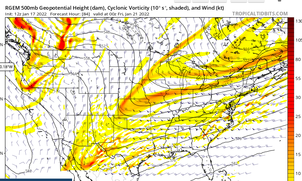
Euro lines up perfectly with the Rgem at 84 hrs. So we have two models in this camp. IMO
-
4
-
1
-
-
1 minute ago, ILMRoss said:
I'll pump the breaks and say @84 never mind. Too much separation. Another event coming but it won't be a kingmaker.
yea, strange b/c it doesn't match the 84 rgem at all really with regard to the trough interaction with the baja wave.
-
12z Rgem... the most phased/sharp trough we've seen yet on modeling for this storm I believe.

-
1
-
-
Just now, CaryWx said:
Is the sharper trough good or bad? Sorry still drinking coffee
Good if you're worried about suppression and a weak/non-event for most.
Though the way things are trending I think i'm more concerned this thing winds up being too amped. The good thing is we're only 96hrs away so how much more drastically could it trend?
-
1
-
-
comparing 12z Rgem and 00z CMC, the new rgem has more fully incorporated the baja low and led to a much sharper/congealed trough. Gulf low already organizing off the texas coast as a result.
-
1
-
 1
1
-
-
12z Rgem appears to be setting up for a monster gulf low riding the arctic front. Can't wait to see the CMC
-
1
-
-
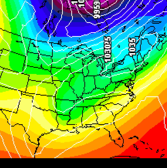
This will probably never pan out, but the 00z Euro shows it starting to snow here around midnight Thursday night and doesn't stop until about 2am Saturday morning.
-
5
-
-
The 72hr 06z Euro 5h panel on tropicaltidbits is looking sexy. any updates from the paid sites?
-
1
-
-
I picked up an inch of fluff on the back side. I'm calling it 5.5 inches of snow/sleet. Highest measured snow depth was 5 inches due to compaction from sleet in between snow. It's easy to see b/c I can measure below and above the sleet/crust layer now and know what I lost to compaction. (measured 4 inches before sleet picked up, and snow under the crust layer only 3 inches now).
-
1
-
-
I can measure a snow depth of 4.5 inches on the car top now. We had 4 inches from the first round of snow and probably around 3/4 inch of sleet but that compacted down to about 4 inches of "snow depth" and now we've gotten a 1/2 top coat of powder on that and still ripping. cha ching! Biggest storm here since the 5.75 inches I got in January 2011. and other than that it's the biggest storm here since Jan 1988.
-
11
-
-
i'm getting obliterated by this last little band that's pivoting right over the western upstate. Think i'm gonna wind up with at least an inch from this.
-
1
-
-
back to ripping snow here. another 1/4 on the board.
-
6
-
-
had a heavy sleet squall line move through a little while ago and drop another 1/4 inch of accumulation. temp down to 27 and wind gusting to 50 mph. looks like a glacier out there and a tiny bit of freezing rain has froze all the snow in place on vegetation. Just an awesome winter storm here... best since January 2011.
-
5
-
-
i'm actually getting more bullish for backside snow for the Upstate. The changeover to snow line is racing northwest right now. It's already moved through gwinnett county, ga. Appears it'll get here by noon and there will still be some convective type showers in the upstate for a few hours after that. Thinking we can pick up another 1-2 to cap off the glacier.
-
5
-
1
-
-
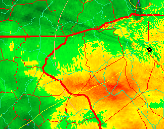
The sleet band looks really narrow on CC radar. Is it freezing rain below that line in southern Greenville county? It's 29.2 here and the rate of temp decreases has sped up in the last 30 minutes. it's pouring sleet, wondering if i'm about to flip to freezing rain? if so... no chance I keep power. Trees are already leaning and sagging from the snow.
Also winds are really starting to crank.
-
7 minutes ago, Snow dog said:
Burrel,
you think we got some goods coming with backside swinging thru this afternoon?
Not really. I'm thinking just novelty flakes with that. if we get really lucky maybe we could get an additional dusting to an inch from that.
-
I'm over 4 inches now. Biggest snow for me since January 2011. Ripping glob flakes mixed with sleet.
-
6
-
-
Puking graupel and flakes now!
-
1
-
1
-
-
i'm at 3.5 inches of accumluation measured on the picnic table. 1/4 inch of that is sleet on top. We've transitioned back to mostly snow with decreasing rates. It seems the convective showers have more sleet/warm air I guess.
also already passing nws GSP's 10% high end map totals. lmao
-
4
-
-
sleet line made it here with that mega band. 3 1/4 inches accumulation before the mix with sleet. Not bad at all. 30.9.
-
4
-
-
come to papa!!!
January 20-22 “bring the mojo” winter storm threat
in Southeastern States
Posted
It is good... real good. lol