

burrel2
-
Posts
2,388 -
Joined
-
Last visited
Content Type
Profiles
Blogs
Forums
American Weather
Media Demo
Store
Gallery
Posts posted by burrel2
-
-
Euro is literally bone dry for the upstate and the NAM is dropping 10 inches of low ratio snow. you tell me?
-
 1
1
-
 1
1
-
-
The NAM needs to stop playing with my emotions.
-
6
-
 4
4
-
-
fwiw, (probably nothing). But the 48hr Hrrr lines up with the nam/rgem if not better with the phase.
-
5
-
 1
1
-
-
yea 18z euro misses. Ugh. lol (didn't really shift much from 12z, just hoping for tick towards the 18z short range models)
-
sorta feel like this 18z euro is going to be a huge deciding factor for the upstate. It really needs to look the 18z Rgem/NAM just looked.
-
4
-
-
Couple thoughts on the potential phasing: It seems like the 18z models diverge on whether or not the baja low gets left behind around hr 60-66. Are we to believe the NAM/RGEM at hour 60 or the GFS/ICON?
For the 00z runs tonight, we will be at hour 54 of the divergence... have to think that close to it happening, we will get some resolution.
FWIW, the 12z Ukmet was actually similar looking to the 18z NAM at 5h with the phasing, just not as strong, and I think the ukmet has a dry bias as well on the n/w side of a precip shield.
-
1
-
-
This is the last panel. 1am Saturday. 6-7 inches of powder has already fallen in the upstate on this run.
Edit: got too excited and posted NAM... corrected to rgem now.
-
6
-
-
Got toe mighty. Need a cig after that Rgem run... WOOOO!!!!
-
6
-
3
-
-
Man I really hope they run is due to some newly ingested data and the other models follow along
-
5
-
-
NAM just said hold my beer, Time to feed the weenies! It’s almost like instead of the northern wave absorbing the southern wave… the southern wave had sucked in the northern wave leading to a beautiful gulf low slider.
-
1
-
-
I could see the day 7/8 thing working out. Euro looks perfect with the progression of the Baja low across the southeast… just doesn’t have any northern energy dropping down to help amplify it. Cmc has the same feature but phases it with the northern stream and boom! Gfs doesn’t have the Baja low but does have a northern stream disturbance dropping down.
-
2
-
-
Basically threats all over the place starting day 7 on all the different globals. Best looking “closest”threat is day 8 on the cmc, it buries the southeast.
euro looks gorgeous on day 7 too… just a little suppressed. Euro looks great again on day 9 but also a tad suppressed. Perfect!
-
2
-
-
Probably worthless but the 12zjma is still phasing and throwing precip way back west
-
Gfs too… got toe mighty!
-
2
-
-
Canadian with a burger boom!!! Next week
-
2
-
-
Imo, it's pretty much game over for the upstate if the baja low doesn't get mostly sucked up in to the trough. The 06z Euro still did this but it was starting to leave a tail of energy behind compared to previous runs. The 12z Nam and 12z Icon sucks it up in a similar fashion, the mostly catch it but leave a bit of a trail behind.
The 12z Rgem leaves a little bit more of it behind.. longer tail, less precip.
12z GFS leaves it completely behind (so much so that it's showing a very weak secondary wave of precip from it.
-
1
-
-
looking at those ensemble members... seems like there is a lot of phased monsters. Looks like around 20 phased monsters, 15 (in the middle), and 15 weak/flat suppressed?
-
4 minutes ago, BornAgain13 said:
6z EPS and Control trended towards a mix of GFS and CMC. Could the Euro be the one to cave.... wow
Not really caving... GFS already moved way more in the direction of the Euro. If the euro pulls back 20% and the GFS pushed forward 80% to meet in the middle. That's a win for the Euro.
-
3
-
1
-
-
06z Euro for the first time in a while actually ticked towards less phasing with the southern stream. Helps thermal profiles for places like raleigh, but hurts precip totals to the west. It has me getting .25 liquid(maybe a little more to come past hour 90). The 00z run had me at .65 liquid.
-
1
-
 1
1
-
-
In case anyone was wondering, here's what all the overnight model runs showed for Clemson, SC.
1pm friday 7pm friday total liquid snow notes 00z ukmet 32/23 32/23 .49(all snow) 5 inch, 10:1(would be higher) doesn't start until after 7pm friday, finishes 8am saturday00z Euro 30/24 28/24 .65(mostly snow) 7 inch kuchera starts 7am friday, 800mb warm nose right at freezing to start, higher ratio snow on back end. ends 3 or 4am saturday00z CMC 34/30 30/27 .06(all snow) Trace kuchera 06z GFS 30/24 28/24 .04 (all snow) .25 inch kuchera starts 3-4pm friday, only last an hour or tow(fringed)06z NAM 29/23 N/A N/A N/A 06z Rgem 33/30 N/A .08(all snow) .5 inch kuchera still ripping at end of run, more to come-
2
-
1
-
-
This old tidbit seems relevant tonight...
UKMET
Subjectively Observed Bias Geographical location of bias Annual/Diurnal attribute Submitted by Date Submitted Operational Implication Suspected Cause Seems better than GFS with forecast of phasing of systems in northern and southern branch of jet North American middle latitudes Anytime NCEP WPC Since fall of 2001 When GFS is showing phasing of systems beyond 84 hours, check UKMET to see if solution is consistent GDAS ? -
2
-
1
-
-
Just now, Beach Snow said:
Feverishly looking for UKMET verification scores…
I'll save you the trouble. They're good. Better than GFS for day 4/5
-
4
-
-
cold enough for all snow in Raleigh and Charlotte. would be higher ratio stuff to the west of that.
Edit: even columbia, SC is borderline all snow.
-
2
-
-
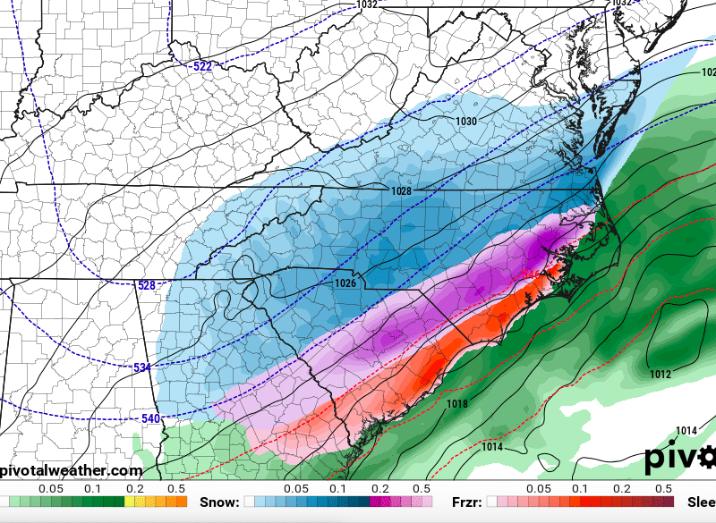
this counts freezing rain and sleet as snow... but you get the idea.

January 20-22 “bring the mojo” winter storm threat
in Southeastern States
Posted
I don't know if anyone in history has ever been "Nam'ed" more than the upstate just did.
The classic other models showing nothing and you are getting nothing but yet the NAM just dumped 8-12 inches on you. NAM'ED!