Burghblizz
-
Posts
1,733 -
Joined
-
Last visited
Content Type
Profiles
Blogs
Forums
American Weather
Media Demo
Store
Gallery
Everything posted by Burghblizz
-

Western Pa / Pittsburgh area Winter Discussion ❄️☃️
Burghblizz replied to north pgh's topic in Upstate New York/Pennsylvania
NAM and GFS agree about as often as opposing political parties - but they have both been pretty consistent for a quick 2”-3” Monday morning (NAM maybe a tad more because it’s actually a little colder) -
Western Pa / Pittsburgh area Winter Discussion ❄️☃️
Burghblizz replied to north pgh's topic in Upstate New York/Pennsylvania
I got a nice band overnight and woke up to about 2” on my car (so we’ll call it slightly less). But then that dry slot was fierce. -
Western Pa / Pittsburgh area Winter Discussion ❄️☃️
Burghblizz replied to north pgh's topic in Upstate New York/Pennsylvania
I have a theory that it’s really undermodeled up the 119 corridor, just west of the ridges. That’s the area that the newer models really show the enhanced screw zone first when the warm tongue is an issue. But it also appears that that area does very well during WWA snows. I could be way off in saying that somehow the positioning relative to the ridges makes that process more efficient - but it sure seems that way. Exhibit A to that theory is that corridor is getting drilled pretty good right now -
Western Pa / Pittsburgh area Winter Discussion ❄️☃️
Burghblizz replied to north pgh's topic in Upstate New York/Pennsylvania
I could see 5” or 6” south east of the city. Moisture looks pretty robust and those areas will be in it longer, I was half expecting some Virga with this first batch, but sticking efficiently. Could be another little storm where we maximize every flake! -
Western Pa / Pittsburgh area Winter Discussion ❄️☃️
Burghblizz replied to north pgh's topic in Upstate New York/Pennsylvania
Meanwhile - snowing pretty hard again right now. Band looks mostly west-east going through the city and just south -
Western Pa / Pittsburgh area Winter Discussion ❄️☃️
Burghblizz replied to north pgh's topic in Upstate New York/Pennsylvania
Basically a guy named Kuchera came up with a complicated formula. We like it because it usually shows more snow. So you will see it more on this forum. But what I think it is is a formula that uses the highest temp found at 500 mb, and thus can account for temps in the column a little better. I think the intial intent was to project how much compacting will take place, but it does usually show more than 10:1 unless there is a lot of sleet. Thats basically what I remember - but I mostly like it because it shows more snow -
Western Pa / Pittsburgh area Winter Discussion ❄️☃️
Burghblizz replied to north pgh's topic in Upstate New York/Pennsylvania
A little over an inch today officially of bonus snow -
Western Pa / Pittsburgh area Winter Discussion ❄️☃️
Burghblizz replied to north pgh's topic in Upstate New York/Pennsylvania
Those Southern Ohio zones (which would figure to do similar to us with this) have a lower threshold. They can pop em up with 4”+ expected -
Western Pa / Pittsburgh area Winter Discussion ❄️☃️
Burghblizz replied to north pgh's topic in Upstate New York/Pennsylvania
These days are nice when u have a decent snowpack. -
Western Pa / Pittsburgh area Winter Discussion ❄️☃️
Burghblizz replied to north pgh's topic in Upstate New York/Pennsylvania
60 days ago...:-)
-
Western Pa / Pittsburgh area Winter Discussion ❄️☃️
Burghblizz replied to north pgh's topic in Upstate New York/Pennsylvania
NAM a little better. Looks like 7-8”. Double digits into Greene and Fayette. Nice little 12-15” weenie area in northern WV. Just need to pop that north a bit (I’m talking that precip area, knowing that it will be shaved down in real life) -
Western Pa / Pittsburgh area Winter Discussion ❄️☃️
Burghblizz replied to north pgh's topic in Upstate New York/Pennsylvania
That was me in Dec ‘92 and Jan 96. But I’ve learned that I’ll deal with that if I get a foot. That’s kind of my threshold Now 1.16 was a kick in the nuts. Got 5” while 40 miles away got 20” Thankful to have been on the good side of that in 03 and 2010 -
Western Pa / Pittsburgh area Winter Discussion ❄️☃️
Burghblizz replied to north pgh's topic in Upstate New York/Pennsylvania
Here were the Euro ensembles on Saturday. Not 5 days out, 48 hours out. As tight of a cluster as you see, with one major outlier. It wound up west of that outlier. Not sure what caused performance that poor, but certainly some time for this to slide NW this time. (Again, from Saturday)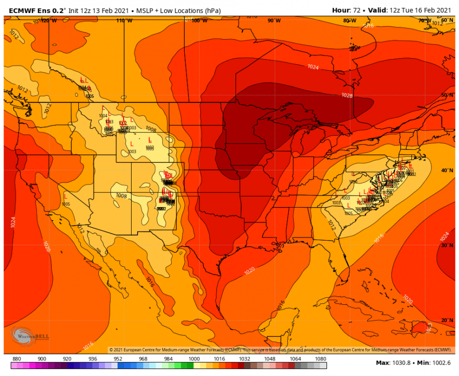
-
Western Pa / Pittsburgh area Winter Discussion ❄️☃️
Burghblizz replied to north pgh's topic in Upstate New York/Pennsylvania
The “science” is the southeast bias in the models. Let’s watch them come to us over the next 24 hours (Of course when we need it...lol) -
Western Pa / Pittsburgh area Winter Discussion ❄️☃️
Burghblizz replied to north pgh's topic in Upstate New York/Pennsylvania
That used to be taken from NWS. They started doing their own like 15 years ago -
Western Pa / Pittsburgh area Winter Discussion ❄️☃️
Burghblizz replied to north pgh's topic in Upstate New York/Pennsylvania
I’m not sure places north and west did that great, even into western Ohio and New York State. Seems like a lot of low ratios and quick moving. I didn’t really look until now, but wanted to see what we missed out on. -
Western Pa / Pittsburgh area Winter Discussion ❄️☃️
Burghblizz replied to north pgh's topic in Upstate New York/Pennsylvania
Right - I like the old “significant accumulation possible” as an alert. But I’d wait for actual totals. Or you pop up a couple scenarios. -
Western Pa / Pittsburgh area Winter Discussion ❄️☃️
Burghblizz replied to north pgh's topic in Upstate New York/Pennsylvania
Lot of moisture streaming up though, and better HP placement. I don’t think this has the 10” potential the last one did, it I’d rather shovel 5” of snow than 10” of potential -
Western Pa / Pittsburgh area Winter Discussion ❄️☃️
Burghblizz replied to north pgh's topic in Upstate New York/Pennsylvania
Skating rink right now, with a lot of precip to go. At least it’s pretty fast moving. We haven’t had a true ice storm in awhile - usually pretty transient on the way to rain. But this looks like it could get rough. I used to like them as a kid because they “felt” like a snowstorm. You got your NWS headlines and off school. -
Western Pa / Pittsburgh area Winter Discussion ❄️☃️
Burghblizz replied to north pgh's topic in Upstate New York/Pennsylvania
It’s Amazing our propensity for night snows -
Western Pa / Pittsburgh area Winter Discussion ❄️☃️
Burghblizz replied to north pgh's topic in Upstate New York/Pennsylvania
Lol - don’t start. I already found myself noticing HRRR soundings holding on to snow a little longer. Maybe we can squeeze out a quick second thump before the ice -
Western Pa / Pittsburgh area Winter Discussion ❄️☃️
Burghblizz replied to north pgh's topic in Upstate New York/Pennsylvania
Thumpin hard right now. I went outside. Need to enjoy every flake for the time spent - lol -
Western Pa / Pittsburgh area Winter Discussion ❄️☃️
Burghblizz replied to north pgh's topic in Upstate New York/Pennsylvania
Icy as hell out again. Not sure if there was more freezing drizzle overnight, or this first batch of snow started as some -
Western Pa / Pittsburgh area Winter Discussion ❄️☃️
Burghblizz replied to north pgh's topic in Upstate New York/Pennsylvania
It’s been a fun year overall, despite this recent mess. Still think this winter has something more in store -
Western Pa / Pittsburgh area Winter Discussion ❄️☃️
Burghblizz replied to north pgh's topic in Upstate New York/Pennsylvania
It does show some blocking and a decent (6”+) hit of snow. Also shows it retrograding through Ohio, and then creating a mess. I’m going to really try not to model watch again until Wednesday