

paxpatriot
-
Posts
353 -
Joined
-
Last visited
Content Type
Profiles
Blogs
Forums
American Weather
Media Demo
Store
Gallery
Posts posted by paxpatriot
-
-
1 minute ago, Mrs.J said:
Yep. Although already seeing road closures on the Frederick Scanner in the Northern part of the county.
And this is a good point. I think WCPS sometimes only sees the county as Hagerstown, when that is definitely not the case. Assume that can also be an issue in FCPS and Frederick as well.
-
 1
1
-
-
Frederick and Washington Counties apparently in it for the long haul today. May the odds ever be in their favor.
-
By far the heaviest rain of the day in Hagerstown. Really coming down now.
-
Just now, Paleocene said:
Montgomery County -- nothing on early dismissal yet. I'm surprised, we're usually one of the first to jump.
Washington County and Frederick County also holding out, it seems. Given that all of the neighbors to the north, west, and east are either cancelled or releasing early, I'm a little surprised.
-
1
-
-
Road conditions are awful in the Hagerstown area. We have about 2 inches of fluffy stuff, but I'll get a better measurement in a bit. Nice to have a little surprise performer this year!
-
1
-
-
Just woke up to a whiteout on the M/D. Very unexpected surprise. Super fluffy and laying at 23F.
-
3
-
-
This freezing drizzle is for real. Almost died walking out to get the dog. Have to believe the roads are treacherous.
-
Definitely living through one of the worst forecast busts I can remember. Even those of us who stayed mostly snow aren’t going to come close to what was forecast on this one. Models were showing 6-12 inches here not 36 hours ago, and I might have 3.5 inches out there. This winter sucks.
-
2
-
-
21F and moderate snow on the M/D. Measured just under 2 inches right now. Not the best accumulating stuff, but man is it cold.
-
1
-
-
Starting to wonder when LWX starts lowering totals for us NW folks. 8-12 inches is not looking particularly good for a forecast right now. Given what the models were showing just 12 hours ago, this is a 6 inches or bust storm up here.
-
2
-
-
24 minutes ago, leesburg 04 said:
Man...so what is going to happen tonight? 1-3" 2-4" 3-6" 1-6?
I’m wondering the same thing. Hagerstown area could get anywhere from 2-3 (Euro) to 6-9 (GFS, NAM, RGEM). Is there any other model still as dry as the Euro?
-
North trend does not appear to be kicking in. Looking like a mostly non-event for us NW folks if this trend is right.
-
Not sure who got my hopes up that the Icon looked better, but 12z looks markedly worse for most of the forum. Weaker overall.
-
Snow finally tapered off on the M/D about an hour ago, but picking up again. With my last measurement, I’m at 13.7 inches for the entire storm. Definitely one of the more memorable and enjoyable storms since I moved to this area.
-
3
-
-
Just now, Eskimo Joe said:
Probably going to be a couple 18"+ reports out of the Catoctins and 12"+ out of the upper portions of Frederick, Carroll, Baltimore, and Harford counties.
Already hearing reports of over a foot of snow at Cascade, MD. They may add another 8-10 inches before its done, so going to be some crazy totals in that area.
-
1
-
-
4 minutes ago, WVsnowlover said:
Radar looks amazing for Hagerstown right now.
Just drove from Hagerstown to Greencastle across the M/D. Didn’t hit moderate snow until the airport on I-81, but it became heavy snow by the border. We have two fresh inches up here and it is ripping.
-
4
-
-
Just now, Baltimorewx said:
He posted a 204 hr forecast lol that’s not what the CMC shows for this storm
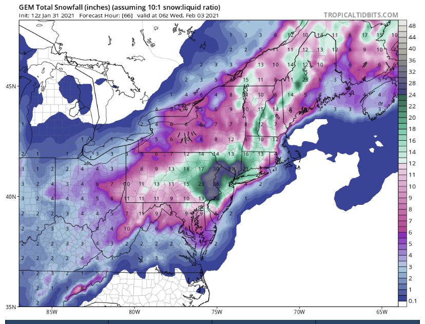
Fixed it, too many images of these maps on my phone!
-
Edit: posted the wrong image, this one covers the current storm.
-
1
-
 2
2
-
 1
1
-
-
14 minutes ago, clskinsfan said:
The gfs gives me another .75 of QPF. I will take that in a heartbeat. It is lightyears better than what the meso's are showing.
Am I the only one in awe of the disparity there? GFS insists we I-81 folks get 8-14 inches, and the NAM’s are a fraction of that. I’d like to think the GFS has a better idea as it hasn’t budged in a number of runs now.
-
2
-
-
The difference between the globals and mesos for us M/D folks seems almost laughable. It seems I can expect anywhere between 3 and 16 inches of snow. Not sure I can recall such a disparity this close to an event between those camps.
-
1
-
-
Do those double-barrelled lows ever actually materialize, or is that the Euro's way of showing that its not sure where the actual center is located?
-
Maybe I'm just naïve, but it seems concerning that we have such big differences with the major models on that feature over New England basically 48 hours from its impact on this storm. Seems like pretty big disparity for a feature so close.
-
Just now, CAPE said:
Yeah if the ens members don't agree with the op at this range then something is broken.
It's GFS vs Euro. Which one will cave..
Is there any other model showing the evolution that the Euro has? Looks more like Euro vs. Everyone Else.
-
Pretty disturbing to have every model on track for a massive hit for the almost the entire forum...except the Euro now. That was a pretty big jump south at 0z for us NW folks. Hope it was just a blip.
January Medium/Long Range Discussion
in Mid Atlantic
Posted
The M/D crew hardly saw a flake yesterday, so this would be quite a gut punch if we miss this one south as well. RGEM has me a little concerned.