dendrite
-
Posts
73,488 -
Joined
Content Type
Profiles
Blogs
Forums
American Weather
Media Demo
Store
Gallery
Everything posted by dendrite
-
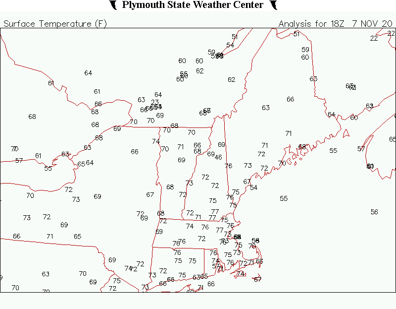
It's only been warmer than the current 75F at CON this late in the season two other times. 78F 11/7/1938 76F 11/20/1991 That 76F is still within reach.
-
72° Getting some Ci now.
-
Low of 49°. lol Already 62°.
-
I’ve had something the past week. My eyes have been itchy, irritated, and watery...eye lids and under my eyes dried, peeling, and a little caked up in the morning. A lot of nasal drip and some phlegm too. Maybe I’m immune now...who knows?
-
70.0°
-
NAM was 538 with zonked out amounts...gotta cut those numbers by 2/3.
-
I tried growing some from seed this spring, but none of them germinated. Pretty cool though. I learned that paw paw flowers are pollinated by flies that are attracted to the stinky scent they give off.
-
62F up here at 530 this time of year is pretty rare. You don't expect to see warmth like this until Christmas eve.
-
I need some stored for Jan and Feb.
-
Wish I could bottle this up.
-
66° SKC Feels great
-
Not to change subjects, but wth is going on in Coos county with COVID? They have jumped to the 5th highest active case county total in the state. There's more cases in Pittsburg than my town.
-
ha. I just didn’t see you over there and saw all of the posts here so figured something may have happened. I rarely go over there so I’m out of the loop.
-
I still have a coating leftover on the north side from the squalls yesterday morning.
-
Phin...were you banned from ampol or something?
-
I really don’t want to let too much politics into this forum when we have a political forum for that. I don’t mind a few general posts, but let’s keep it from going down the heated debate road.
-
I saw way fewer Trump signs around my area vs 16. Way more for Biden vs Hillary too. I don’t base it on signs, but I’m not surprised by the outcome.
-
Biden probably has it won. We’ll see what Trump does wrt the courts. The 2020 disaster continues.
-
Nice morning...not as cold as progged. Looks like we had some -SHSN overnight with the WAA. Clearing now and up to 30.0F off of 26.5F, but that occurred before midnight.
-
Toss Nate Silver further than the NAM
-
Maybe Killington will try to secede from Vermont again?
-
Strange because my forsythia are blooming.
-
Buds are beginning to swell.
-
I never really thought of the OCD aspect, but now that you mention it I agree with that too.