

dendrite
-
Posts
73,513 -
Joined
Content Type
Profiles
Blogs
Forums
American Weather
Media Demo
Store
Gallery
Everything posted by dendrite
-

Feb 10-11 Mid Week Minor Event - Ride the hot hand?
dendrite replied to HoarfrostHubb's topic in New England
A quick couple hours of good lift in the DGZ up here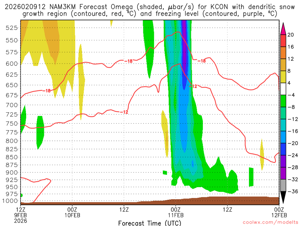
-
Stein saying what we’ve been saying. Not sure what he’s doing in the pool in 3° though
-
Wait that was for your neighbor. March 6 for you.
-
First bare spot 3/14
-
Winter has 6-8 weeks more to live. Make a few more memories before we say goodbye. Then we start partying with the inheritance
-
What’s your pack at now?
-
That’s just climo. There’s some Febs with 0 and some with 10. But we’re just saying what the modeling shows. It’s not a forecast based on climo. It’s some 40s and maybe (maybe not) a warmer one mixed in. It’ll be okay. It probably turns colder again toward the end of the month. Maybe not 10 days of -10 anomalies, but cold enough to snow.
-
As soon as that first bare spot gets exposed he will be raining to Maine and installing before the sweating arrives.
-
In a few more weeks the little gypsy caterpillar will hatch from his egg sac and find its first leaf to munch on. He will go from not being able to envision temps warming up to not being able to envision temps getting cold again.
-
Yeah…BDL averages 4 days of 50+ in Feb since 2000. 7 days of 45+ my math says that’s 1/4 of the days.
-
Well like Scoot said, there’s a chance to pop a warmer 50-55 in there if we DSD with >0C 850s. TBD
-
I’m getting sucked into the either/or vortex…we can run a bit AN for a week and still avoid the big anomalies toward the Plains.
-
Skynet has an AN stretch of +5 to 10. Not sure I’d call that a torch, but multiple days into the mid 40s.
-
I don’t think anyone will be upset about AN midnight temps at this point. The big warm anomalies will be west of us. Days don’t look overly warm on the whole.
-
Feb 10-11 Mid Week Minor Event - Ride the hot hand?
dendrite replied to HoarfrostHubb's topic in New England
It’s basically a little WAA…the sfc low goes north of VT and tries to redevelop on the GOM but ends up more of an inv trough up there. -
Feb 10-11 Mid Week Minor Event - Ride the hot hand?
dendrite replied to HoarfrostHubb's topic in New England
3k was pretty interesting for SW ME -
Feb 10-11 Mid Week Minor Event - Ride the hot hand?
dendrite replied to HoarfrostHubb's topic in New England
You need ticks S. It’s a quick band of WAA precip down there and then slot before the CAA right now. -
Well that was a good run of cold temps, but sayonara, bon voyage, don’t forget to write. Let’s finish winter off more like Valdez instead of Fairbanks.
-
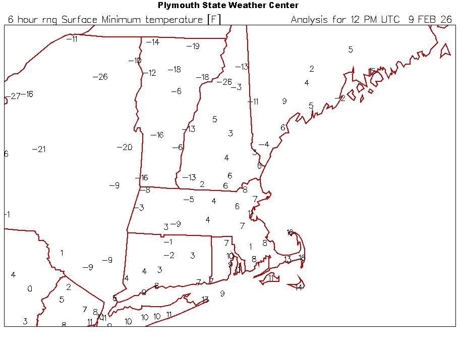
Low was 0.9°…up to 4.8° MWN is -3…HIE -26.
-
Hubb Dave thread
-
Right on cue
-
I can’t recall ever seeing so much fear in here over the threat of a couple of days going a little AN.
-
lol…that’s the storm system. ACATT should want the AI to verify there unless you want the system to stay south.
-
Well snow measuring is an inexact science and probably the most difficult variable we routinely measure. It’s difficult to standardize measurements. And yeah, human error can really increase the errors as well.
-
We can’t even measure them accurately


