

SACRUS
-
Posts
10,370 -
Joined
-
Last visited
Content Type
Profiles
Blogs
Forums
American Weather
Media Demo
Store
Gallery
Posts posted by SACRUS
-
-
Records:
Highs:
EWR: 94 (1949)
NYC: 90 (1980)
LGA: 90 (1955)
JFK: 84 (1980)
Lows:
EWR:38 (1966)
NYC: 34 (1891)
LGA: 42 (1978)
JFK: 41 (2002)
Historical:1917 - The same storm which a day earlier produced eight inches of snow in the Texas panhandle, produced a foot of snow at Denver CO, their heaviest snow of record for the month of May. (David Ludlum)1930 - The temperature at College Park, VA, soared from 43 degrees to 93 degrees to begin an exceptional heat wave. (Sandra and TI Richard Sanders - 1987)1933: An estimated F4 tornado cut a 35-mile path from near Brent into Shelby County, Alabama. The town of Helena, AL was especially hard hit, as 14 people died. The tornado roared through Helena at 2:30 am.1987 - Unseasonably hot weather prevailed in the western U.S. A dozen cities in California reported record high temperatures for the date. Afternoon highs of 93 degrees at San Francisco, 98 degrees at San Jose, 100 degrees at Sacramento, and 101 degrees at Redding, were the warmest of record for so early in the season. The high of 94 degrees at Medford OR was also the warmest of record for so early in the season. (The National Weather Summary)1987 - Parts of the western U.S. were in the midst of a blistering May heat wave. The reading of 100 degrees in Downtown Sacramento CA was their earliest of record. Sacramento CA established daily record highs on nine of eleven days between the 4th and the 14th. (The Weather Channel)1988 - A stubborn low pressure system continued to drench the eastern U.S. with rain. Thunderstorms again produced large hail in North Carolina. (The National Weather Summary)1989 - Thunderstorms swept across Georgia and the Carolinas during the late afternoon and evening hours spawning seventeen tornadoes. A tornado at Toccoa GA injured 15 persons, and a tornado at Chesnee SC killed two persons and injured 35 others. Five tornadoes in North Carolina accounted for five deaths, 88 injuries, and sixty million dollars damage. Thunderstorms also produced baseball size hail at Lake Murray SC, and wind gusts to 78 mph at Brooklyn MD. (The National Weather Summary) (Storm Data)1990 - A strong Pacific cold front moving rapidly inland caused weather conditions at the east end of the Strait of Juan de Fuca in Washington State to quickly change from sunny and calm to westerly winds of 60 mph and ten-foot waves. Three recreational fishing boats capsized in heavy seas off Port Angeles resulting in five deaths. In California, temperatures soared above 90 degrees across much of the state. The high of 101 degrees in downtown Los Angeles was eight degrees hotter than their previous record for the date. (The National Weather Summary) (Storm Data)1995: A supercell thunderstorms brought torrential rains and large hail up to four inches in diameter to Fort Worth, Texas. This storm also struck a local outdoor festival known as the Fort Worth Mayfest. At the time the storm was the costliest hailstorm in the history of the US, causing more than $2 billion in damage. -
Low of 51 now to 58. 0.09 in the bucket. Temps between 50 - 59 today with clouds and showers light rain 0.15 - 0.40. Warmer tomorrow on SW flow but still mainly cloudy and more showers. Tue (5/7) - Wed / (5/8) brief warm up, pending on sunshine more upper 70s / low 80s. Clouds return later this week by Thu/Fri and another cloudy/west weekend for Mothers day. Trough 5/10 - 5/13. Warmer by mid month, but sustained ridging unforeseen through the second week of May.

-
-
Low of 44now to a cloudy 54. Showers pushing in from the SW. Overall period of clouds, showers and near/cooler than normal 5/4 - 5/13. More showers Sun and Mon with a day or two clear/warmup Tue (5/7) and Wed (5/8) 70s / 80s pending on the cloud cover.

-
Pollen cleaner
Looks like 0.75 - 1.00 inch next 3 days. Then later next week/weekend more rain. Dry streak washed away the next 10 days. Lets see if it goes from regular to deluge.
-
 4
4
-
-
59 and mostly cloudy east/onshore flow. Wetter cloudier period the next 10 days. Next warm day or day and half would be Tue (5/4)-Wed (5/5) next week.
-
On 4/26/2011 at 9:17 AM, SACRUS said:
2024:
PHL: 2 (Apr: 1 ; May: 1 ; Jun: ; Jul: ; Aug: ; Sep: )
EWR: 1 (Apr: ; May: 1 ; Jun: ; Jul: ; Aug: ; Sep: )
TTN: (Apr: ; May: ; Jun: ; Jul: ; Aug: ; Sep: )
LGA: (Apr: ; May: ; Jun: ; Jul : ; Aug: ; Sep: )
ACY: (Apr: ; May: ; Jun: ; Jul: ; Aug: ; Sep: )
TEB: 1 (Apr: ; May: 1 ; Jun : ; Jul: ; Aug: ; Sep: )
NYC: (Apr: ; May: ; Jun: ; Jul: ; Aug: ; Sep: )
JFK: (Apr: ; May: ; Jun: ; Jul: ; Aug: ; Sep: )
ISP: (Apr: ; May: ; Jun: ; Jul: ; Aug: ; Sep: )New Brunswick: (Apr: ; May: ; Jun: ; Jul: ; Aug: ; Sep: )
BLM: (Apr: ; May: ; Jun: ; Jul: ; Aug: ; Sep: )
89 Degree Days:New Brnswck: 1
Highs 5/2
Highs
EWR: 90
PHL: 90
TEB: 90
ACY: 89
BLM: 88
New Brnswck: 88
TTN: 87
NYC: 79
LGA: 76
JFK: 66
ISP: 65 -
Highs
EWR: 90
PHL: 90
TEB: 90
ACY: 89
BLM: 88
New Brnswck: 88
TTN: 87
NYC: 79
LGA: 76
JFK: 66
ISP: 65
-
1
-
-
-
11 minutes ago, LibertyBell said:
what wind direction do you guys have? the forecast was for WNW winds and quickly clearing skies which obviously did not happen until now lol
WSW
-
1
-
-
85 now. Clouds clinging to LI
-
1
-
-
Up to 81 today here in CNJ pollen is quite high.
-
Records:
Highs:
EWR: 88 (2010)
NYC: 87 (2001)
LGA: 85 (2001)
JFK: 81 (2001)
Lows:
EWR: 36 (1978)
NYC: 37 (1903)
LGA: 38 (1978)
JFK: 38 (2008)
Historical:1854 - The Connecticut River reached a level of nearly twenty-nine feet at Hartford (the highest level of record up until that time). The record height was reached in the midst of a great New England flood which followed sixty-six hours of steady rain. (David Ludlum)
1857: The Washington Evening Star publishes the first US national weather summary using observations from volunteers to the Smithsonian Institution's cooperative network.
1933: An estimated F4 tornado struck Minden, Louisiana, killing 28 people and injuring 400 others. 500 homes were damaged or destroyed with $1.3 million in damage.
1935 - Snow, ice and sleet brought winter back to parts of southeast Minnesota. Minneapolis received three inches of snow to tie their May record which was established in 1892. (1st-2nd) (The Weather Channel)
1954 - The temperature at Polebridge MT dipped to 5 degrees below zero to esablish a state record for the month of May. (The Weather Channel)
1987 - Thunderstorms produced large hail and heavy rain in Texas. Baseball size hail pounded Dublin, and 3.75 inches of rain soaked Brady. (The National Weather Summary) (Storm Data)
1988 - Strong southerly winds ahead of a cold front crossing the Rocky Mountain Region gusted to 90 mph at Lamar CO. High winds created blinding dust storms in eastern Colorado, closing roads around Limon. (The National Weather Summary) (Storm Data)
1989 - Thunderstorms produced heavy rain in the southeastern U.S. Rainfall totals of 1.84 inches at Charlotte NC and 2.86 inches at Atlanta GA were records for the date. Strong thunderstorm winds uprooted trees in Twiggs County GA. (The National Weather Summary) (Storm Data)
1990 - Thunderstorms produced severe weather from northern Alabama to North Carolina. There were sixty-three reports of large hail or damaging winds, with hail four inches in diameter reported near Cartersville GA. Ten cities in the southeastern U.S. reported record high temperatures for the date as readings warmed into the 90s. Jacksonville FL reported a record high of 96 degrees. Late night thunderstorms over central Texas produced up to ten inches of rain in southern Kimble County and northern Edwards County. (The National Weather Summary) (Storm Data)
1999: Record, low temperatures for the date, were broken in the Deep South. Mobile, Alabama dropped to 46 degrees. Miami fell to 58; Miami Beach bottomed out at 61, and Vero Beach dropped to 47 degrees, all new records. Other stations in Florida also set record cold maximums for the date, including 61 at Jacksonville and Daytona Beach with 66 degrees.
2003: A record-setting 516 tornadoes occurred during May 2003. In particular, during the period May 4-10, 2003, an unprecedented number of tornadoes, 393 total, affected the central and the southern United States. The tornadoes resulted in 39 deaths across four states. Six of these tornadoes were classified as violent (F4) on the Fujita Tornado Intensity Scale.
-
Upto 80 before it became a bit cloudy
-
57 off a low of 54 SSE flow and some low level clouds over CNJ-NYE area. Flow coming around again and sunshine will push us back to the 70s today, low-mid 80s Thu. Onshore,clouds and cooler by Fri and through the weekend with some rain on Sun (maybe the most widespread since 4/3. Warmer 5/6 - 5/8 but storms and showers look to increase. 5/9 - 5/13 perhaps near/below normal. Overall near to above normal with rain chances increases the first week to 10 days of the month.
-
55 minutes ago, winterwx21 said:
Lee Goldberg pointed out that there were actually more below normal days than above normal days in April. NYC had 17 below normal compared to 13 above, but overall the month was 2 degrees above normal because we had some big torch days. Obviously the above normal days tend to be more impressive than the below normal days.
Largest departures
EWR: 4/25,4/26 : -7 - Negative
EWR: 4/16 :+16, 4/29: +15#of - departure days: 12
# pf + deprture days: 17
# of 0 departure days: 1NYC:
NYC: 4/21: -8 , 4/18: -7
NYC: 4/9: +17, 4/29: +15# of - departure days: 13
# of + departure days: 16
# of - departure days : 1
-
2
-
-
Records:
Highs:EWR: 91 (1942)
NYC: 91 (1942)
LGA: 89 (1942)
JFK: 81 (2007)
Lows:
EWR: 34 (1931)
NYC: 32 (1874)
LGA: 42 (1942)
JFK: 40 (1975)Historical:
1852 - A tornado, following the same track as the famous "Tri-state Tornado" of 1925, struck the town of New Harmony IND. Just sixteen persons were killed by the twister, due to the sparse settlement. The "Tri-state Tornado" killed 695 persons. (David Ludlum)
1888: 246 people died in the world's deadliest hailstorm in India. Hailstones were reportedly the size of baseballs. 1600 domesticated animals at Moradabad perished.
1924: A significant tornado outbreak occurred from Alabama to Virginia on the 29 through the 30th. 26 tornadoes were of F2 intensity or greater. A total of 111 people were killed, and over 1,100 injured. An estimated F4 tornado tore through Steedman and Horrell Hill, SC. This tornado killed 55 people.
1953 - A tornado 300 yards in width leveled homes on the north side of Warner-Robins GA, and barracks on the south side of the Warner-Robins Air Force Base. (The Weather Channel)
1987 - Thunderstorms developing along a cold front produced severe weather in Idaho, Utah, Wyoming and Montana. Thunderstorms produced wind gusts to 100 mph in Lincoln, Mineral and Sanders counties. Twenty-three cities in the central and southeastern U.S. reported record high temperatures for the date. Memphis TN was the hot spot in the nation with a record high of 94 degrees. (The National Weather Summary) (Storm Data)
1988 - A cold front produced high winds in the southwestern U.S. Winds gusting to 90 mph in southwestern Utah downed power lines, and damaged trees and outbuildings. The high winds also downed power lines in Nevada, completely knocking out power in the town of Henderson. (The National Weather Summary) (Storm Data)
1989 - Thunderstorms produced severe weather in central and eastern Texas. Hail three inches in diameter was reported at Cool, and thunderstorm winds gusted to 80 mph at Hillsboro. For the first time of record Oklahoma City went through the entire month of April without a single thunderstorm. (The National Weather Summary) (Storm Data) (The Weather Channel)
1990 - Late afternoon and evening thunderstorms produced severe weather in southern Virginia and the Carolinas, with tennis ball size hail reported southeast of Chesnee SC. Thunderstorms moving over the Chesapeake Bay flooded U.S. Highway 50 on Kent Island MD with several inches of water resulting in a seventeen-mile long traffic jam. (The National Weather Summary) (Storm Data)
-
Yesterdays highs
PHL: 90
New Brnswck: 89
TTN: 88
NYC: 87
EWR: 86
TEB: 86
LGA: 85
ACY: 84
BLM: 83
JFK: 82
ISP: 82-
1
-
-
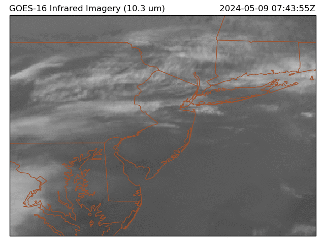
From 89 to 59 cloudy and raw. Can see the extent of the onshore and clouds / marine layer into CNJ. Warm up to the 70s Wed and back to 80s thu as the flow pushes back from the W/SW. This weekend looks cloudy and cooler with some showers. Warmer 5/6 - 5/9 perhaps next shot at 90 in that window.
-
5
-
-
Records: Today
Highs:
EWR: 91 (1974)
NYC:89 (1974)
LGA: 88 (2017)
JFK: 85 (2017)
Lows:
EWR: 35 (1947)
NYC: 32 (1874)
LGA: 39 (1977)
JFK: 36 (1966)
Historical:
1905 - The town of Taylor, in southeastern Texas, was deluged with 2.4 inches of rain in fifteen minutes. (The Weather Channel)
1910 - The temperature at Kansas City, MO, soared to 95 degrees to establish a record for the month of April. Four days earlier the afternoon high in Kansas City was 44 degrees, following a record cold morning low of 34 degrees. (The Weather Channel) (The Kansas City Weather Almanac)
1963 - A tornado, as much as 100 yards in width, touched down south of Shannon, MS. The tornado destroyed twenty-seven homes along its eighteen mile path, killing three persons. Asphalt was torn from Highway 45 and thrown hundreds of yards away. Little rain or snow accompanied the tornado, so it was visible for miles. (The Weather Channel)
1973 - The Mississippi River reached a crest of 43.4 feet, breaking the prevous record of 42 feet established in 1785. (David Ludlum)
1987 - A storm off the southeast coast of Massachusetts blanketed southern New England with heavy snow. Totals of three inches at Boston MA, 11 inches at Milton MA, and 17 inches at Worcester MA, were records for so late in the season. Princeton MA was buried under 25 inches of snow. (The National Weather Summary) (Storm Data)
1988 - Thunderstorms produced large hail and high winds in central Texas. Baseball size hail was reported at Nixon, and wind gusts to 70 mph were reported at Cotulla. Heavy rain in Maine caused flooding along the Pemigewassett and Ammonoosuc Rivers. (The National Weather Summary) (Storm Data)
1989 - Thunderstorms produced severe weather in Arkansas, Louisiana and eastern Texas, with more than 70 reports of large hail and damaging winds. Softball size hail was reported at Palestine TX. Hail as large as tennis balls caused ten million dollars damage around Pine Bluff AR. (The National Weather Summary) (Storm Data)
1990 - A storm system crossing northern New Mexico blanketed parts of the Rocky Mountain Region and the Northern High Plains with heavy snow, and produced blizzard conditions in central Montana. Much of southern Colorado was buried under one to three feet of snow. Pueblo tied an April record with 16.8 inches of snow in 24 hours. Strong canyon winds in New Mexico, enhanced by local showers, gusted to 65 mph at Albuquerque. Afternoon temperatures across the Great Plains Region ranged from the 20s in North Dakota to 107 degrees at Laredo TX. (The National Weather Summary) (Storm Data)
-
Yesterdays Highs 4/28
TEB: 83
EWR:80
NYC: 79
New Brnswck: 79
BLM: 78
TTN: 79
LGA: 76
JFK: 68
ISP: 65-
1
-
-
Up to 80 here and mostly sunny. Warmest of the year so far and since Sep 12. Perhaps a few stray 90s to challenge record highs today. Onshore flow and some clouds later and Tue /Wed bring it down to the 60s with some showers. Similar progression as Apri 14/15 before it cooled down. Warmer by sun/Mon but trough is lingering nearby through the 12th or so before any chance of sustained warmth.
-
1
-
-
Up to 80 clouds and showers along NJ-NY border
-
1
-
-
Up to 74 here and mainly sunny.
May 2024
in New York City Metro
Posted
Does look cloudy 9 - 10 of the next 14 days with rain chances. We'll see how warm Tue/Wed can get,next warm up after then looks like 5/13-5/15 timeframe.