

SACRUS
-
Posts
15,611 -
Joined
-
Last visited
Content Type
Profiles
Blogs
Forums
American Weather
Media Demo
Store
Gallery
Posts posted by SACRUS
-
-
70 / 55 in / out sun. Some 80s in the warmest spots, enough sun , otherwise 70s and some afternoon showers, rain. What goes up must come down - for 18 hours - chill down Thursday with onshore / backdoor. Back up Friday clear out and warms up 20-25 degrees from Thu back to upper 60s / low 70s. Warm Easter weekend , showers and rain on Easter. Near normal next week by way of back and forth with the coolest period 4/6 - 4/8. Much warmer in the 4/10 - mid month period and beyond with ridging into the East coast.
-
Mar:
EWR: +4.5
NYC: +3.9 -
Today
EWR: 82 / 62 (+22)
NYC: 81 / 60 (+23)-
 1
1
-
-
Today's highs
EWR: 82
New Brnswck: 82
NYC: 81
BLM: 81
PHL: 81
LGA: 80
ACY: 80
TEB: 80
TTN: 79
HPN: 78
JFK: 68
ISP: 65 -
2 hours ago, PhiEaglesfan712 said:
Then, there was a huge rainstorm the weekend after (which would have been a snowstorm if it happened earlier in the season).
This does not look accurate. 2025 should be there, not 2023. Plus, some of those months, off memory, I can tell you should have negative temperature departures.
Thanks i need to redo the report
-
2 minutes ago, gravitylover said:
What were the stats for April 2012? My feeble memory says we went over 4 weeks with no rain and 60s-70s every day.
No 90s the month as a whole was +1.5 - +2 and highest was a 3 day strech of 80s mid april. 88 in EWR was the max
-
 1
1
-
-
NYC to 80 as well -
EWR to 80 3 > 80 of the month. NYC to 77 so far -
81 / 53 holding the sun - near records in the warmer spots. 3rd 80 of the month here -
78 / 53 breezy - gorgeous - pollen building -
8 >70 here
71 / 51
-
EWR: 2.8 inches
NYC: Trace
-
2
-
-
Brunt of the rainfall is focused around the periphery of the ridge the next 5 dys / week.
-
1
-
-
18 minutes ago, bluewave said:
On track to finish the March 70° day count just behind 2012.
Time Series Summary for NEWARK LIBERTY INTL AP, NJ - Month of Mar days reaching 70°
Click column heading to sort ascending, click again to sort descending.1 1945 10 0 2 2012 9 0 3 1946 8 0 4 2026 6 1 5 2016 5 0 - 1998 5 0 - 1989 5 0 - 1986 5 0 - 1921 5 0 - 1913 5 0 - 1910 5 0 Mar 2012 was +8.7 but never reached 80 . Just consistently warm each day. This month will end around +4.2 in EWR
-
16 minutes ago, bluewave said:
On track to finish the March 70° day count just behind 2012.
Time Series Summary for NEWARK LIBERTY INTL AP, NJ - Month of Mar days reaching 70°
Click column heading to sort ascending, click again to sort descending.1 1945 10 0 2 2012 9 0 3 1946 8 0 4 2026 6 1 5 2016 5 0 - 1998 5 0 - 1989 5 0 - 1986 5 0 - 1921 5 0 - 1913 5 0 - 1910 5 0
+20 daily dep day coming up, records looks just safe in the big sites EWR, NYC, LGA etc-
1
-
-
Records:
Highs:
EWR: 85 (1998)
NYC: 86 (1998)
LGA: 82 (1998)
JFK: 74 (1986)
Lows:
EWR: 22 (1964)
NYC: 14 (1923)
LGA: 24 (1964)
JFK: 21 (1964)
Historical:
1771-72: Washington in the winter of 1771-72 had over 50 inches of snow - much like the snowy winter of 1995-1996 when 40-60 inches of snow fell in the Washington area. (Washington Weather Book 2002 by Ambrose, Henry, Weiss)
1805-06: During the winter of 1805-06 only 4.5 inches of snow fell similar to the winter of 2000-2001. (Washington Weather Book 2002 by Ambrose, Henry, Weiss)
1843: Four feet of snow was still on the ground at Gardiner, ME following the snowiest March on record.1890 - Saint Louis, MO, received 20 inches of snow in 24 hours. It was the worst snowstorm of record for the St Louis. (David Ludlum)
1892: The “Grim Reaper” at work? An outbreak of significant tornadoes raked parts of TX - OK - KS - NE. Near Wellington, KS, 4 people in a farming family died when a reaper was thrown into their home by an F4 tornado. The same storm injured 13 family members in another home. (Ref. Weather Guide Calendar with Phenomenal Weather Events 2011 Accord Pub. 2010, USA)
(David Ludlum)
1907: This month was very warm in Oklahoma City, OK. Many daily records remain on the books, including three daily high temperature records and six daily records for the warmest low temperature. The hottest temperature ever recorded in March also occurred during this year: 97° and the warmest low temperature ever recorded in March: 68°. Overall, the month ranked as the second warmest March ever; with an average temperature of 59.5°, slightly more than nine degrees above normal. (Ref. Wilson Wx. History)
1933: 37 people were killed and 170 were injured as an F4 tornado moved through Jones, Jasper, Clarke counties in Mississippi. (Ref. Wilson Wx. History)
1942: 107 inches of rain fell during the month at Puu Kukui at Maui, Hawaii to set the U.S. record for rainfall in one month. The same place also holds the annual rainfall record for the United States with 578 inches in 1950.1954 - The temperature at Rio Grande City, TX, hit 108 degrees, which for thirty years was a U.S. record for the month of March. (The Weather Channel)
1959: A round of severe storms caused damage across much of Oklahoma. In Noble and Pawnee Counties, tornadoes caused damage to farms, while in Shawnee, a golf ball sized hailstone knocked one person unconscious. Baseball size hail fell in Thackerville, with some stones as large as 11 to 12 inches in circumference. This created holes in roofs, windshields, and even produced craters in the ground. (Ref. Wilson Wx. History)1962 - A tornado struck the town of Milton, FL, killing 17 persons and injuring 100 others. It was the worst tornado disaster in Florida history. (David Ludlum)
1973 - A devastating tornado took a nearly continuous 75 mile path through north central Georgia causing more than 113 million dollars damage, the highest total of record for a natural disaster in the state. (The Weather Channel)
1979: The maximum temperature for the date is 85 °F in Washington, DC and also in 1981. (Ref. Washington Weather Records - KDCA)
1981: The maximum temperature for the date is 85 °F in Washington, DC and also in 1979. (Ref. Washington Weather Records - KDCA)
1987 - March went out like a lion in the northeastern U.S. A slow moving storm produced heavy snow in the Lower Great Lakes Region, and heavy rain in New England. Heavy rain and melting snow caused catastrophic flooding along rivers and streams in Maine and New Hampshire. Strong southerly winds ahead of the storm gusted to 62 mph at New York City, and reached 87 mph at Milton MA. (The National Weather Summary) (Storm Data)
1988 - March went out like a lion in eastern Colorado. A winter-like storm produced 42 inches of snow at Lake Isabel, including 20 inches in six hours. Fort Collins reported 15 inches of snow in 24 hours. Winds gusted to 80 mph at Centerville UT. Albuquerque NM received 14 inches of snow. (The National Weather Summary) (Storm Data)
1989 - Afternoon thunderstorms produced severe weather from North Carolina to Pennsylvania. Thunderstorm winds gusted to 76 mph at Cape Henry VA. While squalls blanketed northwest Pennsylvania with up to 9 inches of snow, thunderstorms in eastern Pennsylvania produced golf ball size hail at Avondale. (Storm Data) (The National Weather Summary)
1990 - The month of March went out just as it came in, like a lamb. Marquette MI, which started the month with a record high of 52 degrees, equalled their record for the date with a reading of 62 degrees. (The National Weather Summary)
1991: Anchorage recorded an all time seasonal snowfall total of 145.9 inches.
1996: March ended another month of extreme dryness. The period from July 1995 through March 1996 was the driest period ever at many locations across western Kansas, with records dating back 120 years. The wheat crop was almost completely wiped out by the drought. (Ref. Wilson Wx. History)
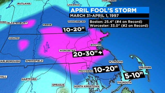
1997: During the peak of the storm from about 11 p.m. March 31 to 3 a.m. April 1, snow fell in Boston at an almost unheard-of rate of 3 inches per hour, some of the heaviest Boston had ever seen. Numerous lightning strikes and thunderclaps accompanied the extremely heavy snow, which accumulated one foot (12 inches) in just that four hour period. Moderate to heavy snow continued through midmorning before tapering off. The 25.4 inches that fell at Boston's Logan International Airport was the third-biggest snowstorm in Boston history (biggest in the month of April) behind the North American blizzard of 2003 (27.5 inches ) and the Northeastern United States blizzard of 1978 27.1 inches and made April 1997 the Boston's snowiest April on record (the previous record being a mere 13.3 inches). It also set a record for Boston's greatest April 24-hour snowfall. Parts of New England received 50 to 70 mph wind gusts at the height of the storm. Providence recorded 18 inches of snow which was the fourth greatest on record at the time. Other parts of New England reported more than 30 inches] and up to three feet with Worcester receiving 33 inches, the city's largest snowfall in history. (Ref. The Major Late Season Snowstorm) Ref. (NWS Ranking for Storms between 1956 and 2011) This is the 38th Worst Snowstorm
2006: March 2006 was not only the driest March but also tied the record of the driest month in the last 26 years at Annandale Weather Center with October 2000. No measurable precipitation occurred in Annandale for 18 days from March 3rd through March 20th. This is now the longest period without measurable precipitation since 2001 when the 26-year record was set of 34 days from Oct. 17th - Nov. 19th. (Annandale Weather Center)
2010 - Jacksonville, Florida's, record streak of days with high temperatures below 80 degrees comes to an end at 105 days. It was also Jacksonville's first 80 degree reading of the year. The previous latest first 80 degree day was on March 14, 1978
2010: After three significant low pressure systems drenched the region, Massachusetts, Rhode Island, and New Jersey all measured their wettest March in 116 years. Of the storms striking the Northeast in March, the huge Nor'easter that hammered the region on March 12-14 was the fiercest. Another rainstorm on March 29-31 pushed numerous rivers over their banks in Rhode Island and Massachusetts, resulting in historical flooding across Rhode Island. Residents in East Providence clamored aboard boats to evacuate their homes. Storm total rainfall reached 9.97 inches in Washington County, Rhode Island. The monthly total of 16.34 inches set an all-time monthly record in Providence, Rhode Island, and Boston, Massachusetts, with 14.87 inches, had its soggiest month in 55 years. (Ref. Weatherwise U.S. Weather Highlights of 2010 page 5) -
66 / 50 warmest start since last sep. Enough sun the warmest spots get to 80 today. Warm but clouds Wednesday, still an outside shot at 80 in the warmest spots. Thu chill down on onshore backdoor, reversed on Friday back in the upper 60s / low 70s. The weekend is warm but still clouds and showers on easter. By the th and beyond near normal overall. Perhaps next warmup is at mid month. -
yesterdayEWR: 73 / 46 (+13)
NYC: 73 / 47 (+13)-
2
-
-
Made it to 74
-
Up to 68 ahead of the mostly cloudy the last hour here - maybe more sun by 2 could get us to 70 in CNJ.
-
Weekend
Fri 3/27
EWR: 65 / 41 (+7)
NYC: 65 / 41 (+7)
Sat 3/28
EWR: 45 / 31 (-8)
NYC: 44 31 (-9)
Sun 3/29
EWR: 58 / 32 (-2)
NYC: 54 / 34 (-3) -
Records:
Highs:
EWR: 86 (1998)
NYC: 82 (1998)
LGA: 79 !(1998)
JFK: 72 (1979)
Lows:
EWR: 22 (1970)
NYC: 16 (1887)
LGA: 23 (1970)
JFK: 22 (1970)
Historical:
1805: New York's City's Battery Park was strewn with 24-inch snow rollers, from a ferocious storm between the March 26th and March 28th. Snow rollers are natural snowballs that are formed when winds blow over a snow-covered surface.
1823 - A great Northeast storm with hurricane force winds raged from Pennsylvania to Maine. The storm was most severe over New Jersey with high tides, uprooted trees, and heavy snow inland. (David Ludlum)
1848: On six reported occasions, the water flow over the American Falls has been entirely blocked by ice and ceased to fall. But only once has this happened on the much larger Horseshoe Falls.
1899 - A storm which buried Ruby, CO, under 141 inches of snow came to an end. Ruby was an old abandoned mining town on the Elk Mountain Range in the Crested Butte area. (The Weather Channel)
1970: The day before, Easter was not very pleasant across northern New Jersey as up to 20 inches of snow and temperatures plunged from spring-like readings near 60° on March 26th to 2° on this date. Single digit and below zero readings occurred across parts of northern Pennsylvania. (Ref. Wilson Wx. History)1977 - Hartford, CT, hit 87 degrees to establish a record for the month of March. (The Weather Channel)
1987 - A storm spread heavy snow across the Ohio Valley and Lower Great Lakes Region. Cleveland OH received sixteen inches of snow in 24 hours, their second highest total of record. Winds gusting to 50 mph created 8 to 12 foot waves on Lake Huron. The storm also ushered unseasonably cold air into the south central and southeastern U.S., with nearly one hundred record lows reported in three days. (The National Weather Summary) (Storm Data)
1988 - A winter-like storm developed in the Central Rockies. Snowfall totals in Utah ranged up to 15 inches at the Brian Head Ski Resort, and winds in Arizona gusted to 59 mph at Show Low. (The National Weather Summary) (Storm Data)
1989 - Thunderstorms developing along and ahead of a slow moving cold front produced large hail and damaging winds at more than fifty locations across the southeast quarter of the nation, and spawned a tornado which injured eleven persons at Northhampton NC. (The National Weather Summary) (Storm Data)
1990 - Low pressure produced heavy snow in central Maine and northern New Hampshire, with up to eight inches reported in Maine. A slow moving Pacific storm system produced 18 to 36 inches of snow in the southwestern mountains of Colorado in three days. Heavier snowfall totals included 31 inches at Wolf Creek Pass and 27 inches at the Monarch Ski Area. (The National Weather Summary) (Storm Data)
1991: Seventeen tornadoes occurred during the month in Oklahoma, setting an all time record. Oklahoma averages about four tornadoes during the month of March. (Ref. Wilson Wx. History)
1993: This apparently was not “soft” hail; good thing nobody’s head was in the way. Hail to the size of baseballs fell from Braxton to D’lo, MS. A number of mobile homes were “punctured” by the hail. (Ref. Weather Guide Calendar with Phenomenal Weather Events 2012 Accord Pub. 2011, USA)
2003: Mar. 30th: A late season snowfall left 1 to 3 inches of accumulation west of a line from Charlottesville to Baltimore City. Above 1500 feet where nearly all of the falling snow was able to accumulate, 4 to 8 inches of snow was reported, with isolated locations above 3000 feet reporting up to 12 inches. The heaviest snowfall falls in the eastern West Virginia mountains, with 16.5 inches at Davis. Blacksburg, Virginia, reported 11 inches. A foot or more fell at Boone and West Jefferson in North Carolina.
(Ref. WxDoctor)
2005: In Colorado, near blizzard conditions occurred east and southeast of Denver during the overnight as winds sustained winds up to 35 mph with gusts to 50 mph produced blowing snow and dropped visibilities at times to near zero. Considerable drifting of 2 to 4 feet was also reported. Snowfall totals included: 8 inches near Castle Rock, 7 inches near Sedalia and 6 inches near Parker but Denver only reported 0.3 inches with gusty winds. Further north, the same storm system triggered numerous small thunderstorms, including a few brief tornadoes from east of Mason City, IA through Mitchell County, Iowa to near the Minnesota-Iowa state line. This area was near the center of low pressure and nearby cold/warm fronts that served as a 'triple point' to focus severe weather development. Known tornado touchdowns (local time) included: 6 miles west of Osage, IA at 2:04 pm, NW side of Stacyville, IA at 2:13 pm, and on the state line south of Adams, MN (Mower/Mitchell County) at 2:18 pm. All damage was rated F0. Wind damage also occurred in southeast Minnesota, east and northeast of Rochester, MN from wind speeds of 60-70 mph. Poseyville in extreme southwestern Indiana had a wind gust of 69 mph. (Ref. Wilson Wx. History) -
54 / 44 warmup and ridge upon us but clouds in the way of some of the hotter temps. 70s warmest spots today in/out of the clouds all week some showers too mainly wed eveing (falling from 80s to 40s in NJ), Mid 70s to 80 in the warmest Tue/Wed. Thu onshore flow chills it down to the 40s. Wamring up Fri through Easter but again clouds. Brunt of the rains around the ridge west of here. Clear out by the 6th but cool back towards normal. -
Brunt of the heaviest rain falls west but still a warm / cloudy and wettish week once to Wed - Easter Weekend.

April 2026
in New York City Metro
Posted
Records:
Highs:
EWR: 82 (1978)
NYC: 83 (1917)
LGA: 80 (1978)
JFK: 75 (1978)
Lows:
EWR: 28 (1969)
NYC: 12 (1923)
LGA: 27 (1969)
JFK: 26 (1969)
Historical:
1786: A heavy snowstorm in the Northeast dumped a foot of snow from New Jersey to New Hampshire. Five piers of the Charles Bridge were destroyed at Boston, MA by gale force winds and high tides. (Ref. Wilson Wx. History)
1807: 30 inches of snow fell at Danville, VT with total snow depth of 60 inches on the ground. Heavy coastal damage occurred from huge waves. (Ref. Wilson Wx. History)
1875: The London Times published the first daily newspaper weather map. The first American newspaper weather map would be issued on 5/12/1876 in the New York Herald. Weather maps would first appear on a regular basis beginning on 5/9/1879 in the New York Daily Graphic.
1912 - A tornado with incredible velocity ripped into downtown Houston, TX, breaking the water table and giving the city its first natural waterspout. (The Weather Channel)
1918: A strong cold front moved through the upper Midwest. Temperatures ahead of the front climbed into the 60s and 70s. Meanwhile, temperatures fell into the 20s by the end of the day behind the front. Fayette, IA had a high temperature of 79° and a low temperature of 23°. This 56 degree diurnal temperature change is the greatest ever recorded there. (Ref. Wilson Wx. History)
1923 - Residents in the eastern U.S. awoke on "April Fool's Day" to bitterly cold temperatures. The mercury plunged to -34 degrees at Bergland MI and to 16 degrees in Georgia. (David Ludlum)
1924: April Fool's coastal low pressure dropped 5.5 inches snow in Washington, DC an April record and 10 inches in Frederick, MD. (Ref. Washington Weather Records - KDCA)
1945: Snow fell across Denver and northern Colorado for 51 consecutive hours on this date through April 3rd. While the storm was did not produce excessive snow, the long duration made the event a heavy snow producer. Downtown Denver reported 10.7 inches while 9.5 inches was reported at Stapleton Airport. This was an unusually cold air mass for this time of year. The high temperature of 26° on April 2nd and 17° on April 3rd were low maximums for the dates. The high of 17° on April 3rd was a record low maximum for April.
(Ref. Wilson Wx. History)
1960: The first weather satellite, TIROS 1 (Television and Infra-Red Observation Satellite) began sending pictures back to Earth. The TIROS series would have little benefit to operational weather forecasters because the image quality was low and inconsistent. The most critical understanding achieved from the new technology was the discovery of the high degree of organization of large-scale weather systems, a fact never apparent from ground and aircraft observations.
1970: 11 inches of snow fell at O'Hara Airport, Chicago closing the airport. This is the biggest snowstorm for so late in the season. (Ref. Wilson Wx. History)
1973: A tornado touches down near Brentsville, Virginia, then traveled to Fairfax hitting Woodson High School. This F2 tornado injured 37 and caused $14 million in damage.
1974: A wind gust of 82 mph was recorded at Nashville, TN, the fastest known wind gust ever recorded in the city. (Ref. Wilson Wx. History)
1978: The maximum temperature for the date is 88°F. in Washington, DC. (Ref. Washington Weather Records - KDCA)
In Latrobe, PA, a gust of win picked up an elderly man and hurled him into the sidewalk; he was killed. Winds at the Latrobe airport were measured at 85 mph. (Ref. Weather Guide Calendar with Phenomenal Weather Events 2011 Accord Pub. 2010, USA)
1987 - Forty-five cities across the southeastern U.S. reported record low temperatures for the date. Lows of 37 degrees at Apalachicola FL, 34 degrees at Jacksonville FL, 30 degrees at Macon GA, and 22 degrees at Knoxville TN, were records for April. (The National Weather Summary)
1987 - A tornado touched down briefly during a snow squall on the south shore of White Fish Bay (six miles northwest of Bay Mills WI). A mobile home was unroofed and insulation was sucked from its walls. (The Weather Channel)
1988 - A powerful spring storm produced 34 inches of snow at Rye CO, 22 inches at Timpas OK, 19 inches at Sharon Springs KS, and up to 35 inches in New Mexico. Severe thunderstorms associated with the same storm spawned a tornado which caused 2.5 million dollars damage at East Mountain TX. (The National Weather Summary) (Storm Data)
1989 - Up to six inches of snow blanketed the Adirondacks of eastern New York State and the Saint Lawrence Valley of Vermont. Up to a foot of snow blanketed the Colorado Rockies. (Storm Data) (The National Weather Summary)
1990 - Thunderstorms produced severe weather in Texas, from southern Arkansas and northern Louisiana to southern Georgia, and from northern South Carolina to the Upper Ohio Valley during the day and evening. Thunderstorms spawned a tornado at Evergreen AL, and there were more than eighty reports of large hail and damaging winds. Thunderstorms produced baseball size hail north of Bastrop LA, and produced damaging winds which injured one person west of Meridian MS. (The National Weather Summary) (Storm Data)
1997: Mother Nature played a cruel springtime joke on the northeast. After the area had basked in 70 degree warmth for several days, a strong nor'easter moved up the coast, dumping up to 3 feet of snow in some areas. The storm began on March 31st, and winded down by midday on this date. A 978 millibar low cutoff just south of New England spun a tremendous amount of moisture in from the Atlantic with southern New England and eastern New York bearing the full brunt of the storm. 500,000 people lost power because of the heavy, wet snow and high winds. Five people were killed. At its peak, the storm knocked out power to nearly 13% of New England or 750,000 people. Boston, MA recorded 25.4 inches of snow for the storm, all in 24 hours for its greatest 24 snowfall on record, its third biggest snowstorm overall and their snowiest April ever. (Ref. The Major Late Season Snowstorm) Ref. (NWS Ranking for Storms between 1956 and 2011) This is the 38th Worst Snowstorm(Ref. Wilson Wx. History)
2004: Lightning hit a townhouse near Sinking Springs, Pennsylvania. It came through a glass door and struck a metal cane inches away from where an elderly woman was using her recliner. She was unhurt but a 4-alarm fire was ignited in a nearby townhouse by the bolt. (Ref. Weather Guide Calendar with Phenomenal Weather Events 2012 Accord Pub. 2011, USA)