wxmx
-
Posts
3,741 -
Joined
-
Last visited
Content Type
Profiles
Blogs
Forums
American Weather
Media Demo
Store
Gallery
Everything posted by wxmx
-
Texas/New Mexico/Louisiana/Mexico Obs And Discussion Thread Part 8
wxmx replied to wxmx's topic in Central/Western States
Yes, the region has to watch the very cold air intrusion Tue/Wed which will feature a s/w crossing the area a day afterwards. -
Texas/New Mexico/Louisiana/Mexico Obs And Discussion Thread Part 8
wxmx replied to wxmx's topic in Central/Western States
Colder than forecasted, and definitely wetter. Drizzle lasted for over 50 hours...nothing was forecasted until the very last minute. A few hours of stratocumulus snow were included (first I ever witnessed, you can see the rather uncommon sounding we experienced, you can even see in one of the pics that the higher elevations missed the snow) for a trace to small accumulations in places, plus freezing drizzle and freezing fog, making it the second event this far down this winter.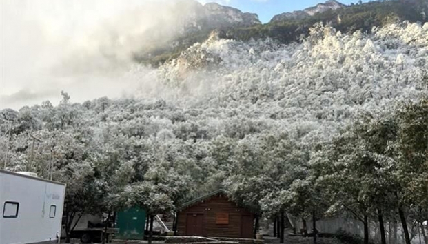
-
Texas/New Mexico/Louisiana/Mexico Obs And Discussion Thread Part 8
wxmx replied to wxmx's topic in Central/Western States
And during my bday to boot ;)....Most probably it will be gone in one of the next few runs. -
Texas/New Mexico/Louisiana/Mexico Obs And Discussion Thread Part 8
wxmx replied to wxmx's topic in Central/Western States
Wrong way BBB (Baja Bowling Ball) shown in the 12z GFS . -
Texas/New Mexico/Louisiana/Mexico Obs And Discussion Thread Part 8
wxmx replied to wxmx's topic in Central/Western States
All is games and fun until you migrate a subtropical-like ridge into the Arctic circle and a massive 1063mb high barrels down the continent. -
Texas/New Mexico/Louisiana/Mexico Obs And Discussion Thread Part 8
wxmx replied to wxmx's topic in Central/Western States
Agree with your analysis. The difference between the models, so far up to 12z, is in the mean trough placement. The Euro is more progressive, with a less -PNA pattern that evolves into neutral/slightly positive. In consequence the mean trough is placed along the central CONUS, with a positive titled trough digging into NW MX. The reason, I think, is in how they handle the MJO. The Euro tugs it along into more favorable phases (8, 1), before plunging it into the circle of death. The GFS prefers phases 7 & 8 which would favor storminess along the Pacific coast, and undercutting, at least partially, the building trough further east. It's very hard to pinpoint the Pacific energy, which has been loaded with storms that dig south in this pattern...so even in a pattern where you have relatively shallow Arctic air entrenched, a Baja bowling ball would deepen the cold in the column and have more snow along it's track vs. freezing rain. The -EPO pattern looks pretty interesting, and the next 2 weeks (at least) look to be loaded with arctic air for our neck of the woods (Plains). The 10 day 12z Euro is just historic Christmas snow about to happen for a lot of people. -
Texas/New Mexico/Louisiana/Mexico Obs And Discussion Thread Part 8
wxmx replied to wxmx's topic in Central/Western States
Yeah, but not too much. A full phasing could suppress the storm south, and give Houston another taste of snow. -
Texas/New Mexico/Louisiana/Mexico Obs And Discussion Thread Part 8
wxmx replied to wxmx's topic in Central/Western States
Yeah, and pretty early in the season. The Euro is bullish as well. It all comes down to how much phasing of the current Baja low goes on as the Polar Jet brings an s/w to meet it. The models are trending for much more interaction with the latest 12z runs, hence the sudden change of tune for this parts in relatively short notice. -
Texas/New Mexico/Louisiana/Mexico Obs And Discussion Thread Part 8
wxmx replied to wxmx's topic in Central/Western States
Models are starting to show snow for places > 5000 ft around here for this Friday, with the GFS being the most bullish. Pattern allows for storm after storm from the Pacific to dig south. A very cold pattern is taking shape for the Christmas week as well. It's a truly exceptional weather pattern.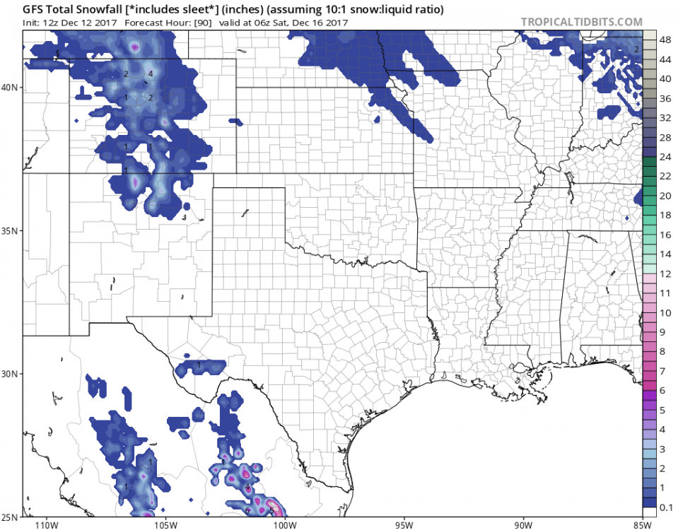
-
Texas/New Mexico/Louisiana/Mexico Obs And Discussion Thread Part 8
wxmx replied to wxmx's topic in Central/Western States
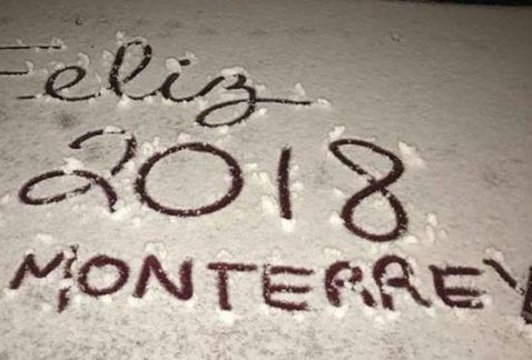
We didn't get the snow jackpot, but the big prize was so close that I could smell it. From my bedroom window you could see the mountains to the NW and N that got the main snow band. The highway from Monterrey to Laredo was closed with vehicles stranded for over 15 hours. Reports indicate 10+ inches of snow there (40 kms north of Monterrey). Mountains to the NW showed incredible gradients, with some peaks completely snow capped, with at least 1.5 feet of snow, probably closer to 2 feet at least. While 3 kms to the east there was probably less than 6 inches. Mountains to my south are higher, but probably got less than 6-8 inches top. In another news, the pattern appears to reload, with models showing the classic Hawaiian trough/Alaskan ridge progressing east into a W Pac ridge, mid Conus trough. Even the 6z GFS today shows a clear and extreme McFarland signature, with a 588dm ridge into south Alaska :o. It's in the long range, so I won't take it very seriously until it shows in the <7 days progs.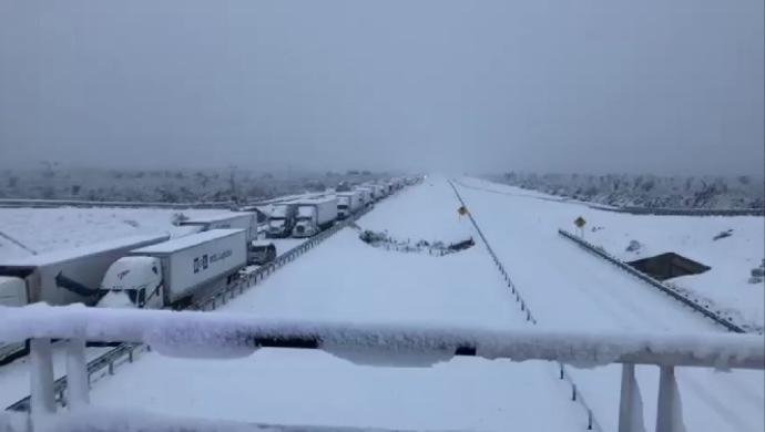
-
Texas/New Mexico/Louisiana/Mexico Obs And Discussion Thread Part 8
wxmx replied to wxmx's topic in Central/Western States
Yes, it is -
Texas/New Mexico/Louisiana/Mexico Obs And Discussion Thread Part 8
wxmx replied to wxmx's topic in Central/Western States
Here around the state: http://www.elnorte.com/libre/players/mmplayer.aspx?idm=89149&te=100&ap=1 -
Texas/New Mexico/Louisiana/Mexico Obs And Discussion Thread Part 8
wxmx replied to wxmx's topic in Central/Western States
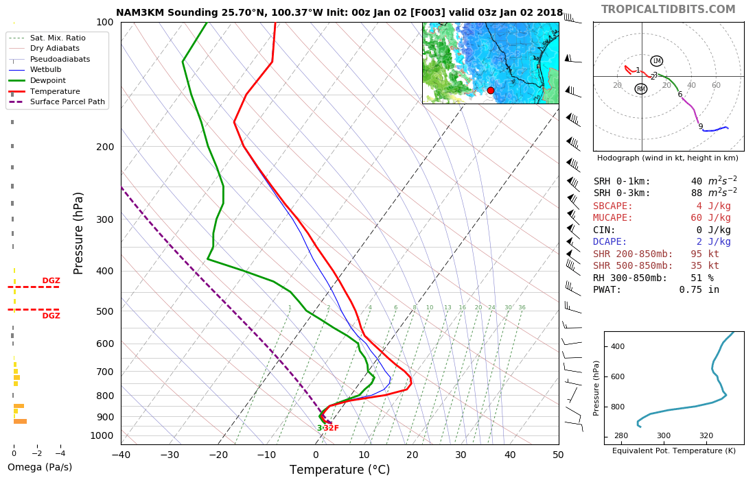
Increasingly likely that the low lands here we'll see accumulating snow. Modeling has trended colder, wetter and more energized with almost every single run since Dec 3rd. Now looking at mesoscale models and the Euro that are developing a heavy snow band about 50-80 kms north of Monterrey. Some models show more than 10"of snow in that band. The 12z GFS shows over an inch of precipitation IMBY while the whole column plummets below freezing. Not all would be snow, but at least half of it would (conservatively) if taken verbatim. It would be the largest snowfall here in 50 years. -
Texas/New Mexico/Louisiana/Mexico Obs And Discussion Thread Part 8
wxmx replied to wxmx's topic in Central/Western States
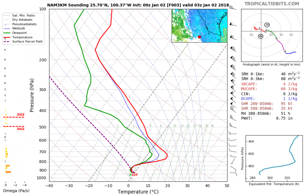
Models have trended for the polar jet s/w to phase with the stj s/w in NW MX, bringing colder air and more moisture. This has translated to enhanced probabilities of wintery precipitation IMBY...and my literal BY could see snowflakes, not just the mountains. This would beat the earliest snowfall from Dec 12, 1997 in modern times. The synoptic setup is similar to Dec 1997 and Dec 2004, but with a less tilted trough and a bit less height crash, although the Pacific ridge is much stronger, allowing to tap a bit colder air from Canada. 850mb temps in 1997 and 2004 dipped around -5C, I expect similar this time, although the coldest models show something around -7/-8 C. The boundary layer will be relatively warm for the most part of the event, with temps hovering above freezing, although models have trended colder and are now showing freezing for a few hours Friday morning. That and bands of heavier snowfall could allow for some trace or little accumulation near the valley (500-600m ASL) with a nice tight gradient the further up you go, up to maybe a foot above 2000m. Latest GFS (Tue 12z)
-
Texas/New Mexico/Louisiana/Mexico Obs And Discussion Thread Part 8
wxmx replied to wxmx's topic in Central/Western States
Chances of wintry precipitation are increasing in the higher parts of MBY for Thu/Fri. Kind of early this far south. -
Texas/New Mexico/Louisiana/Mexico Obs And Discussion Thread Part 8
wxmx replied to wxmx's topic in Central/Western States
Models have been playing catchup with this cold shot for MBY. Strato snow is now in play, I think. Cold is stronger, earlier than forecasted, plus is drizzling, which most models didn't show. To be fair, drizzle is usually not well forecasted. Not saying there will be any accumulation, qpf is going to be meager, but maybe some surprise dusting in the morning...not bad considering we are almost 2 years since last subfreezing temp. -
Texas/New Mexico/Louisiana/Mexico Obs And Discussion Thread Part 8
wxmx replied to wxmx's topic in Central/Western States
Early November and my early swim laps are still a delight in an open air pool Just a couple of weak cold fronts have gone through MBY, when the average should be closer to 5-6. Tampico had 8" of rain yesterday (my parents live there) in less than 3 hours, with rainfall rates of 5"/hr at times (close to 6"/h at some point). Flash flooding was tremendous. This happens when there's still and abundant pool of moisture and a very warm Gulf still, while upper atmosphere is slowly cooling, even a weak disturbance can get these things going in a violent fashion. -
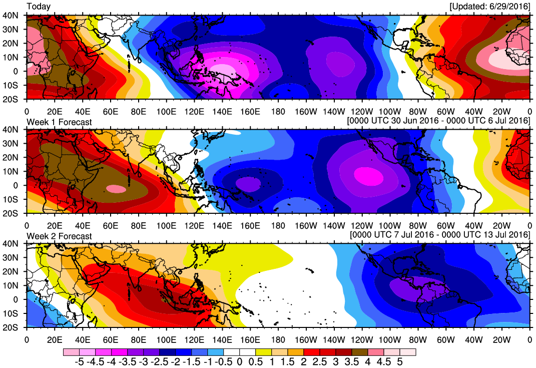
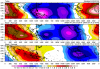
It seems so, as a strong CCKW/MJO pulse appears to be headed for the Atlantic past week 1 (Credit: http://mikeventrice.weebly.com/mjo.html)
-
Devastating tornado strikes Joplin, Missouri
wxmx replied to Hoosier's topic in Weather Forecasting and Discussion
They acknowledge the chair in the wall and the hose in the tree as evidence of the strength of the tornado. -
Devastating tornado strikes Joplin, Missouri
wxmx replied to Hoosier's topic in Weather Forecasting and Discussion
It looks like the branch partially detached from the tree because of the action of the wind, the hose blew in and then the branch snapped back -
Devastating tornado strikes Joplin, Missouri
wxmx replied to Hoosier's topic in Weather Forecasting and Discussion
Ok, gotcha. This limitation is for all tornado ratings, but they show more often the stronger the tornado. -
Devastating tornado strikes Joplin, Missouri
wxmx replied to Hoosier's topic in Weather Forecasting and Discussion
But there are structures that can withstand winds >210 ... though they are not that common (think reinforced concrete structures). Not sure if the gap between those type of structures and well built structures that can't withstand winds >210 mph is large, or if there's no calibration for the kind of winds that could destroy the "super-structures". IOW, what would be the kind of damage for 220mph? for 250mph? -
Devastating tornado strikes Joplin, Missouri
wxmx replied to Hoosier's topic in Weather Forecasting and Discussion
I really understood your point from the beginning, I was playing devil's advocate. Also I thought your range for low-end EF-5 was really restrictive... being that EF-5 baseline is >200mph and 210mph wasn't a low-end in your opinion, you left only 205mph as the unique value for low-end EF-5s (going by 5mph increments)... but I see your point about the realistic upper end in windspeed of a tornado (which I think it can be >220mph) -
Devastating tornado strikes Joplin, Missouri
wxmx replied to Hoosier's topic in Weather Forecasting and Discussion
Would a 145kt Cat 5 hurricane be low end? That's ~10mph above the cat 5 baseline -
Devastating tornado strikes Joplin, Missouri
wxmx replied to Hoosier's topic in Weather Forecasting and Discussion
What would be a high-end EF5?