
Caveman
-
Posts
219 -
Joined
-
Last visited
Content Type
Profiles
Blogs
Forums
American Weather
Media Demo
Store
Gallery
Everything posted by Caveman
-
With the mid-level low at that position and intensity, how can it not hold onto the surface low? When you see a closed 500 mb low at that position any time of year...be aware!
-
1.5" on my board; won't melt it until tomorrow morning...I have observed no sleet to this point but i haven't been hanging outside all day either, but each jaunt outside...all snow every time. It's varying in intensity. It was bringing it about 30 mins to and hour ago! Valley Green, northern York County. And I will not be throwing snowballs today as my arm is still recovering from the other day!
-
For me, baseball generally. Os and Phils specifically.
-
Had a nice walkabout in our woods and fields today...I'll remember it in July God willing!
-
I agree with you about website design and user interface. The changes are often superficial, aimed at creating a more modern appearance, but they don’t necessarily make the site more informative or functional.
-
It's been snowing, albeit very lightly, ALL DAY here. About 3 pm, it kinda evolved into a drizzle/snizzle. Made for great snowball throwing...my shoulder will be slightly sore in the am...but I still "kinda" got it.
-
Yes...my observation was 0.5" with 0.33" liquid. And my location is ~2 miles SSW of KMDT...We had heavy sleet for over an hour last evening...and I do mean heavy to the point the plows came through and pushed the accumulated sleet off the roads...
-
I’m not sure if everyone here follows JB’s posts on WxBell, but he firmly emphasizes the importance of studying teleconnections, the Madden-Julian Oscillation (MJO), and historical weather events with similar 500 mb anomalies. He often notes that he cannot rely solely on models the way many younger forecasters do. Instead, his extensive experience allows him to recall past weather events across all seasons and identify similar upper-air patterns and surface maps. Given that history often repeats itself in meteorology, this approach provides valuable insights. (Analog forecasting)... From my observations over the years, JB is an excellent medium- and long-range forecaster. He is also known for his brutal honesty, particularly when addressing the inconsistencies and biases present in weather models. While I’m not here to advocate for him, I do recognize that he is a highly skilled and knowledgeable meteorologist.
-
If the NAM 3km is correct...you just might get your wish. At ~2:1, Lanco is looking at about 0.6-0.7 liquid falling almost as all sleet. Uhhhhh...models!
-
Wow! Man, I just don’t remember that! But then again, I’m not sure what I had for dinner last evening either…
-
37°F for my max after a 24°F min...currently 30°F. Much colder than than my point and click from NWS today...
-
The consistency across all global weather models strongly indicates an upcoming shift in the weather pattern. The most notable change is that Pennsylvania will be positioned within a storm track expected to bring ample precipitation over the next few weeks. Additionally, as we move later into winter and transition toward the warmer season, the southeastern ridge will attempt to establish itself. With the polar vortex projected to split between both hemispheres, there will likely be significant opportunities for winter weather over the next 4–5 weeks. Given the current conditions, much-needed precipitation is on the way. Even if a portion of it falls in frozen form, this period of winter is shaping up to be a memorable one—especially for lifelong residents of the KMDT area.
-
6.7" snow with 0.36" liquid for a very high ratio of 18.6 snow:liquid Valley Green, northern York County. The 3rd week of January is living up to its climatological "norms" if you will. Just walked the property and it is serene, crystal clear, and calm. Came in just to warm up a bit! The dogs didn't seem to mind the fresh snow cover and frigid temps!
-
6.7" here in Valley Green, northern York County...will melt the gauge in the am. Looking forward to a Bills v Eagles February showdown...?
-
1:00 pm; 1" of snow on the board...finally! Valley Green, northern York County. I didn't melt down the gauge though for the liquid...
-
24 eggs just might require a monthly payment?
-
Dealing with thermal issues pales when compared with dealing with Federal Income Taxes and the complicated laws that go along with them! The wx is my sanity; I'd rather stare at upper air charts and skew-Ts as opposed to what counts as income and what is deductible!
-
0.8" as of 4am -SN Valley Green, York County, PA
-
Total storm event: 2.3" snow with 0.18" liquid. Valley Green, northern York County
-
0.07" liquid with 0.8" as of 7am in Valley Green, northern York County...
-
the biggest mistake the nws ever made was not issuing a hurricane warning for north jersey and nyc for sandy! nws tries to be too fancy as opposed to operating under their mantra as to being a weather ready nation. cwa forecasting is a broadbrush and many wfo have divided counties to account for differences in the sensible weather observed. bottom line…i agree with the zero sense comment.
-
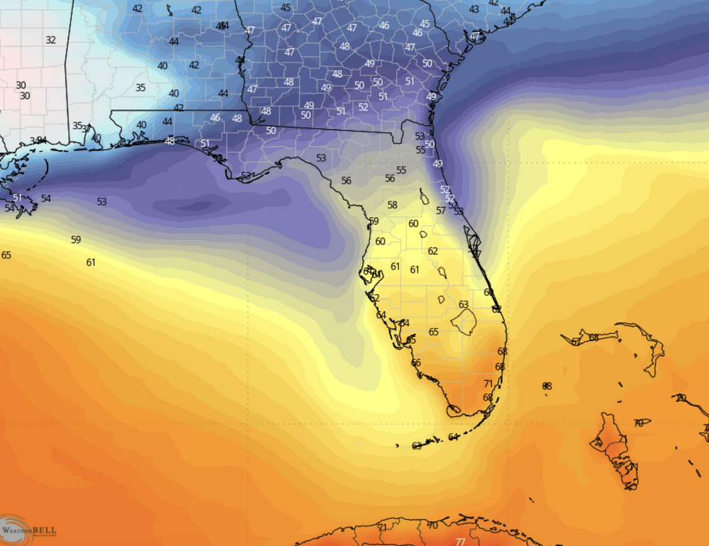
Many of you are obviously savy to the college football game, but the ND-PSU rivalry is huge! Both teams travel very well so Miami will be a hoot next week! Not that it matters too much, but the GFS progged temps for gametime afternoon.
-
A few were mentioning their precip totals for 2024...My gauge is ~3 miles SSW of KMDT which went into the books just under 43" for the year. At our humble abode, we measured just under 42" for the year. Fairly close agreement for having throughout the year rather diverse measurements for our convective precip events.
-
I am curious as to your implication as to no commentary...? Please elaborate if you'd like...
-
This is an impressive mid-latitude cyclone; nice mid-level water vapor depiction! https://weather.cod.edu/satrad/?parms=continental-conus-09-48-1-100-1&checked=map&colorbar=data