buckeyefan1
-
Posts
13,470 -
Joined
Content Type
Profiles
Blogs
Forums
American Weather
Media Demo
Store
Gallery
Everything posted by buckeyefan1
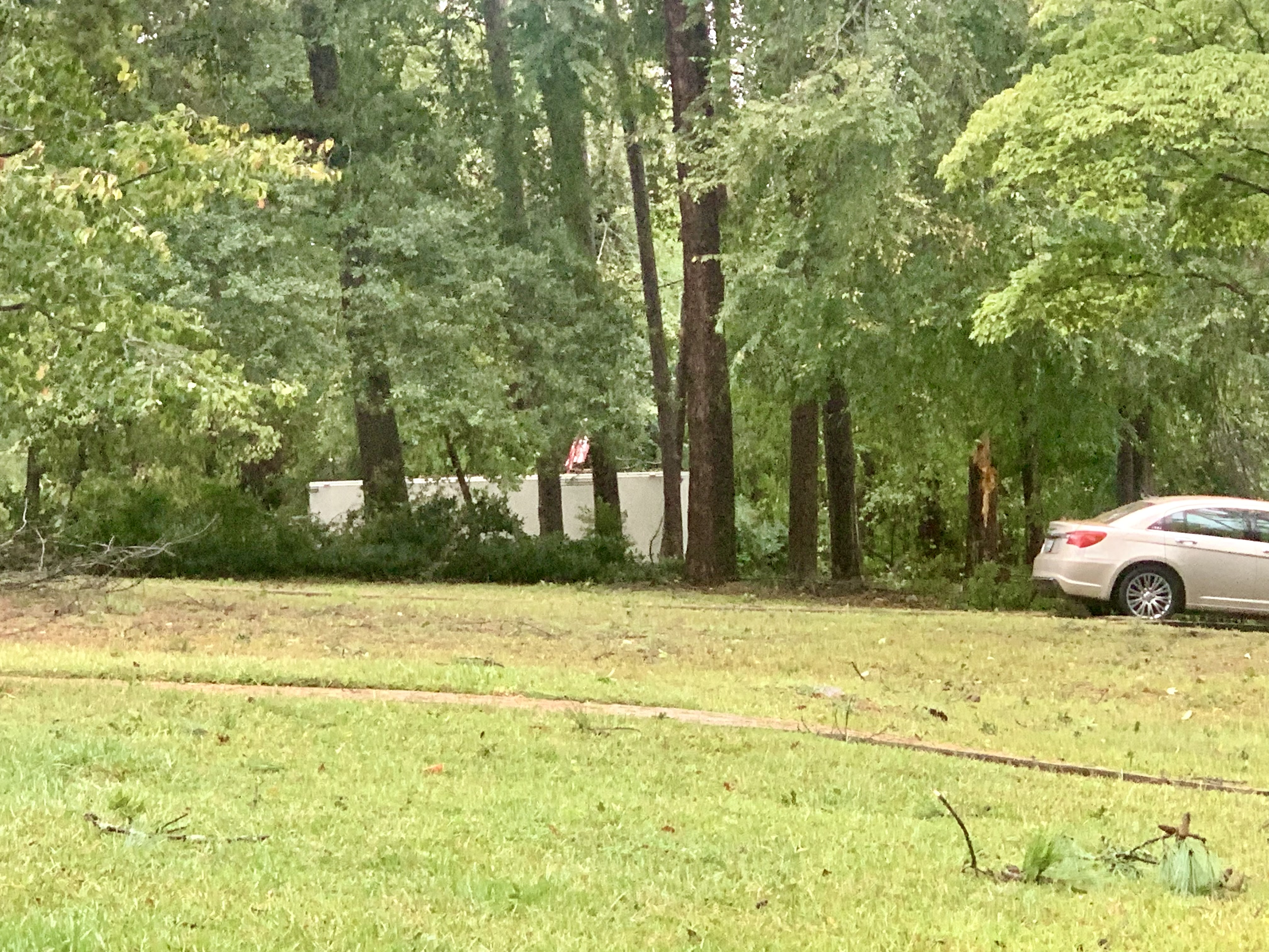
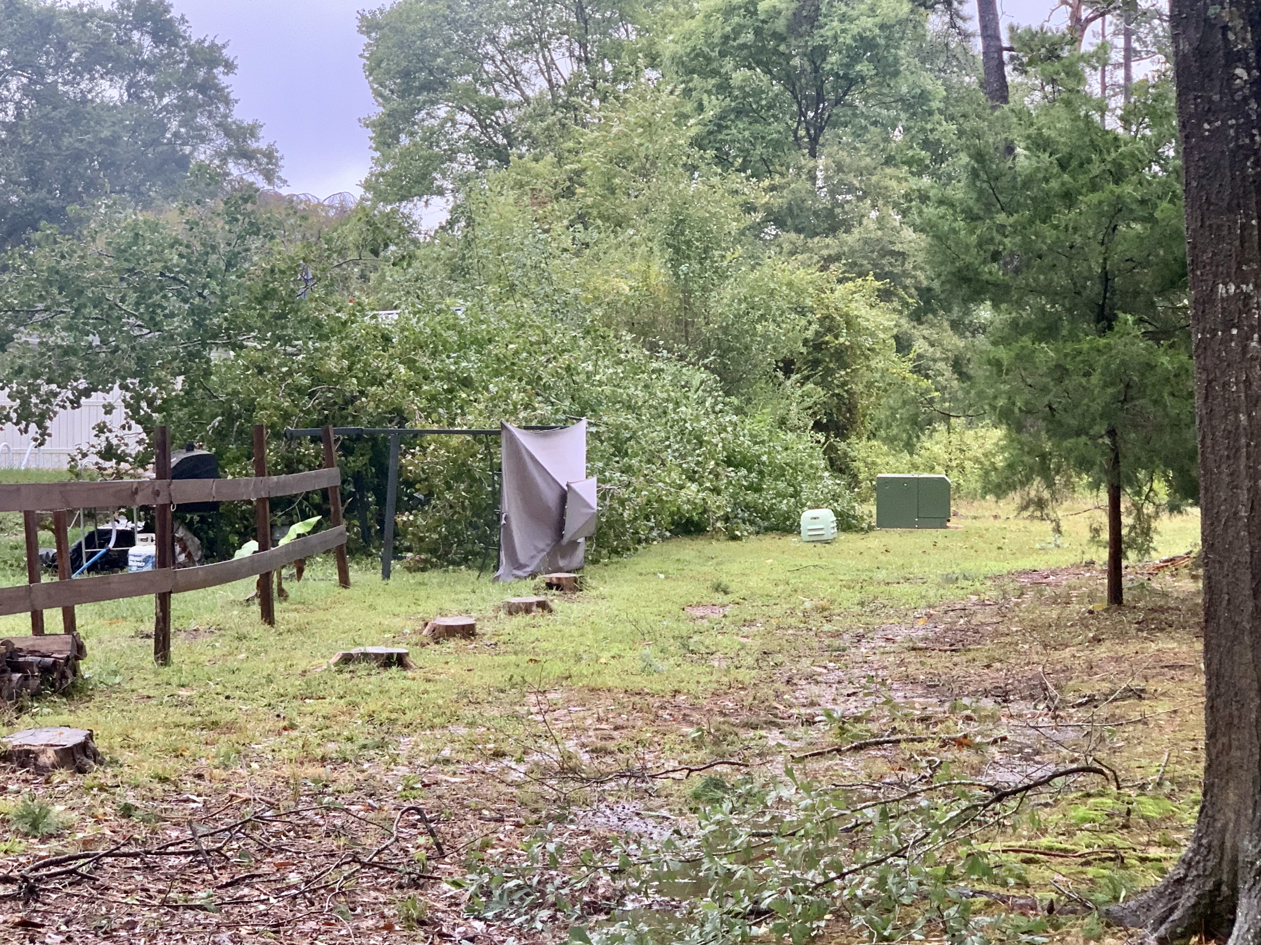
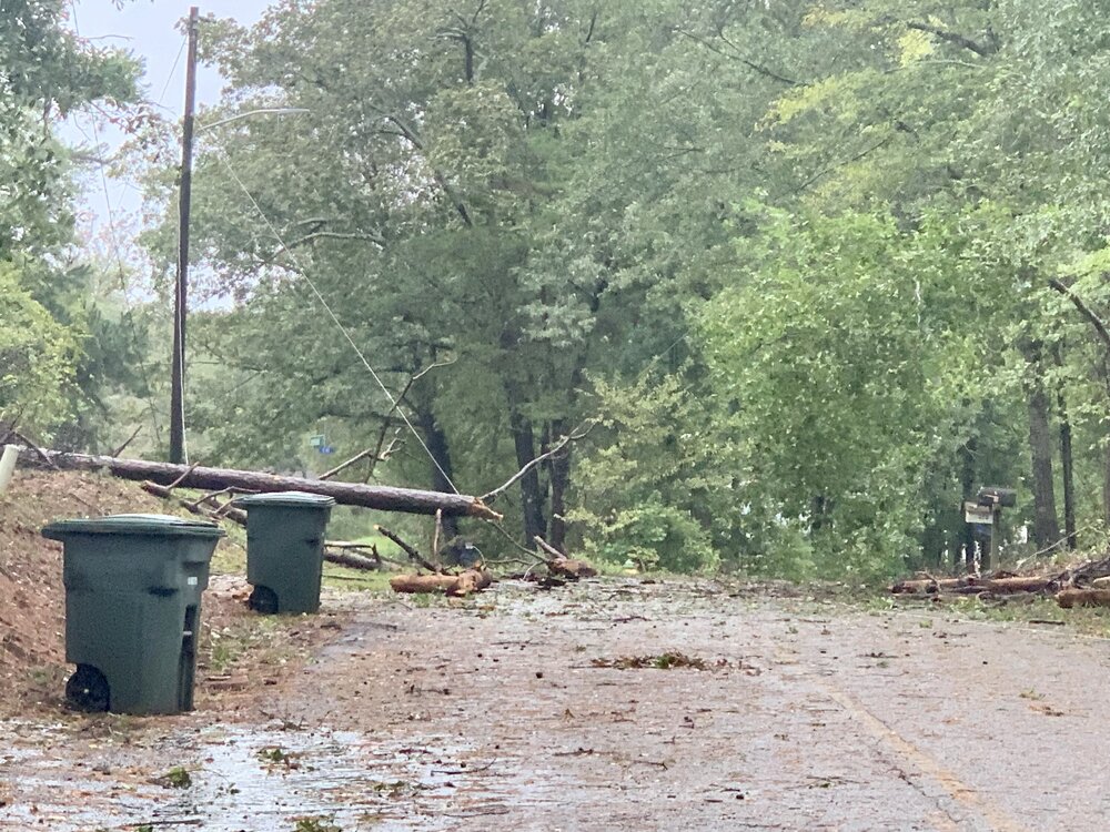
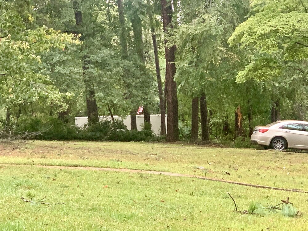
-
Outside my front door

-
Indeed it is! Don’t hate
-
Ya’ll…I’m in what’s left of the eye
-
Yes. It’s really bad everywhere
-
Brad posted this on fb
-
Flash Flood Warning SCC073-077-272030- /O.EXT.KGSP.FF.W.0088.000000T0000Z-240927T2030Z/ /00000.0.ER.000000T0000Z.000000T0000Z.000000T0000Z.OO/ BULLETIN - EAS ACTIVATION REQUESTED Flash Flood Warning National Weather Service Greenville-Spartanburg SC 717 AM EDT Fri Sep 27 2024 ...FLASH FLOOD EMERGENCY FOR PICKENS AND OCONEE COUNTIES... The National Weather Service in Greenville-Spartanburg has extended the * Flash Flood Warning for... Oconee County in upstate South Carolina... Pickens County in upstate South Carolina... * Until 430 PM EDT Friday. * At 717 AM EDT, emergency management reported hundreds of trees down preventing rescue operations. Shelter in place and do not travel unless fleeing floodwaters. Significant flooding is ongoing in multiple locations, resulting in road closures, first-floor inundation, and damage to some structures. The risk of life-threatening landslide activity continues to increase in the South Carolina mountains. Between 5 and 8 inches of rain have fallen. The expected rainfall rate is 1.5 to 2.5 inches in 1 hour. This is a FLASH FLOOD EMERGENCY for Pickens and Oconee Counties. This is a PARTICULARLY DANGEROUS SITUATION. SEEK HIGHER GROUND NOW! HAZARD...Life threatening flash flooding. Heavy rain producing flash flooding. SOURCE...Emergency management reported. IMPACT...Life threatening flash flooding of creeks and streams, urban areas, highways, streets and underpasses. Extensive flooding of homes and businesses. Widespread road closures. Widespread life-threatening landslide activity. * Some locations that will experience flash flooding include... Easley, Clemson, Seneca, Walhalla, Pickens, West Greenville, Welcome, Central, Pendleton, Liberty, Westminster, Gumlog, Norris, Six Mile, Tallulah Falls, Salem, Lake Keowee, Keowee Toxaway State Park, Devils Fork State Park and Lake Jocassee. PRECAUTIONARY/PREPAREDNESS ACTIONS... Move to higher ground now! This is an extremely dangerous and life-threatening situation. Do not attempt to travel unless you are fleeing an area subject to flooding or under an evacuation order. Heavy rain is significantly increasing the risk of landslides, especially in areas where slides have occurred in the past. Slides can destroy single homes and other structures and large sections of roads. If you are in the warned area, you should not travel, except to move away from flash flood or landslide dangers. If you are in the vicinity of a stream near the heavy rainfall, especially on a mountainside, or at the base of a mountain or in a cove, move immediately to a safer location. Turn around, don`t drown when encountering flooded roads. Most flood deaths occur in vehicles. In hilly terrain there are hundreds of low water crossings which are potentially dangerous in heavy rain. Do not attempt to cross flooded roads. Find an alternate route. && LAT...LON 3450 8307 3460 8316 3460 8317 3461 8323 3470 8335 3482 8331 3482 8327 3493 8316 3494 8311 3500 8310 3509 8278 3505 8275 3507 8257 3501 8259 3502 8254 3498 8255 3483 8248 3467 8279 3447 8300 FLASH FLOOD...OBSERVED FLASH FLOOD DAMAGE THREAT...CATASTROPHIC EXPECTED RAINFALL RATE...1.5-2.5 INCHES IN 1 HOUR
-
Flash flood emergency alert made me jump again
-
Power here is out and I have underground utilities Easily 60+ gusts and the freaky noises continue
-
Gusting close to 60 now here
-
It's not the first
-
Helene is east of the track, but the mid level low and surface low are separating. The mid low looks like it's heading more nne and the surface is heading n. The gfs looks to be right lol
-
I'm hearing trees falling Have I said lately that I'm not fond of these sounds when it's dark outside
-
That was a noticeably higher gust just now. Had to be close to 50mph
-
Gusting close to 40 at the moment and I'm hearing noises that aren't of the soothing kind outside
-
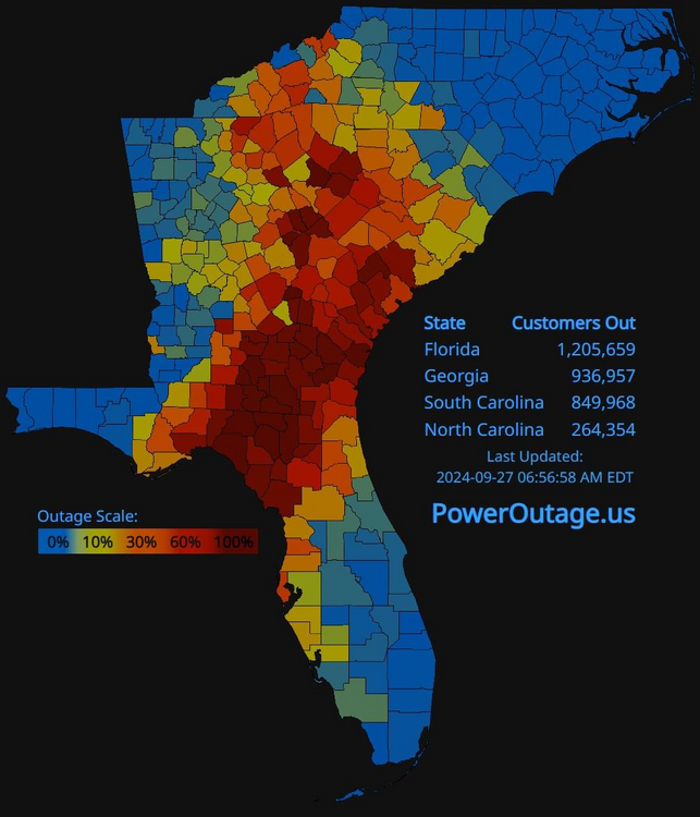
gsp .NEAR TERM /THROUGH TONIGHT/... ***A HISTORIC RAINFALL EVENT IS UNDERWAY FOR THE SOUTHERN APPALACHIANS AND VICINITY WITH WIDESPREAD/LOCALLY CATASTROPHIC FLASH FLOODING EXPECTED*** As of 315 am: Moderate to heavy rain continues across the forecast area early this morning. Rainfall rates associated with the ongoing activity are relatively tame...generally .25-.5" per hour (albeit locally heavier). Nevertheless, flash flooding continues to steadily worsen...especially across portions of the NC Blue Ridge. The center of Hurricane Helene is currently near Vidalia, GA...and is already accelerating (current speed ~40 mph) toward the north. Tropical rainbands...possibly producing rainfall rates of 1-2" per hour... will begin to rotate across the CWA during the 08-12Z time frame. This is when the flash flood situation...which is already severe in some areas...will become potentially catastrophic... especially in locations that received the brunt of the predecessor event over the past 36 hours (i.e., counties encompassing the Blue Ridge escarpment...note that this also includes the city of Asheville and vicinity). It`s very possible that ongoing warnings will be upgraded to EMERGENCY designation in these areas. Reservoirs along the Catawba River chain are also running high and these could be breached as enuf water may not be able to be released beforehand. Additional rainfall amounts of 3-6 inches are expected across all but the southern and eastern fringe of the CWA (where 1.5-3" are expected). This additional rainfall will result in...at the very least..."run-of-the-mill" flash flooding across much of the remainder of the CWA. Winds remain a secondary concern...but nonetheless quite concerning, as Helene made landfall as a Cat 4 last evening, and the fast-moving nature of the cyclone isn`t giving it a lot of time to weaken as the expanding wind field advances toward the forecast area. Gusts of 35 to 45 kts are being reported as far north as Augusta...about 90 miles north of the cyclone center...and confidence is increasing that damaging winds (gusts 55-65 mph) are going to be realized across at least the western part of our area, especially as the tropical bands around the center begin pushing in around daybreak. Gusts across the higher elevations could reach 80 mph. The combination of these wind gusts with saturated soil is likely to result in widespread power outages across the western half of the area. Helene will continue to advance quickly W=>NW of the forecast area late this morning into the afternoon, with quickly improving weather conditions as the column dries quickly. However, flooding on some larger tributaries will linger into at least Saturday, while main stem river flooding will linger into early next week.
-
Helene is hauling north at 30mph, making a beeline here and if that alarm goes off one more time...
-
Did you forget your old log in? You need another red tag sir and it's nice to see you drop in. I'm getting the same texts from friends there as I wait for it to arrive here
-
It is eerie to hear! It's been pouring for hours and the wind is picking up. It sucks not being able to see anything EDIT: My phone going off for the flood just made me jump lol
-
Indeed. The land dance is a thing
-
Yes to both! It's a great way to spend the afternoon taking pictures Helene is giving it everything it has for sure @GaWx those are some pretty nasty cells all around you. Stay safe!
-
It was 85mph this morning. Insane
-
I was on Lady's Island (Beaufort) for 5 years before moving up here I'm not sure exactly where you are, but I can say that 28 to 64 is a beautiful drive
-
I've been in the upstate since 2020 I'm just to the nw of seneca, but before walhalla
-
There's a banter thread for a reason. Please use it. Now back to your regular scheduled hurricane discussion