

LithiaWx
-
Posts
9,945 -
Joined
-
Last visited
Content Type
Profiles
Blogs
Forums
American Weather
Media Demo
Store
Gallery
Posts posted by LithiaWx
-
-
Looking at super res velocity mode you can see wind bows scattered about the main QLCS. I’m not expecting widespread wind damage here but definitely there will be some areas that end up with them. Speaking about western GA
-
Probabilities
: Click for Complete Product Text.
TornadoesProbability of 2 or more tornadoes Low (20%)
Probability of 1 or more strong (EF2-EF5) tornadoes Low (5%)
Wind
Probability of 10 or more severe wind events Mod (60%)
Probability of 1 or more wind events > 65 knots Low (20%)
Hail
Probability of 10 or more severe hail events Low (20%)
Probability of 1 or more hailstones > 2 inches Low (10%)
Combined Severe Hail/Wind
Probability of 6 or more combined severe hail/wind events High (80%)
-
Will be fun :
from NWS
Batten down the hatches! Appears the line of strong to severe storms is moving faster than expected into western GA. Could arrive into Polk, Haralson, Carroll and Heard Counties shortly after 10 PM. Be prepared for damaging winds, very heavy rain and frequent lightning.
   URGENT - IMMEDIATE BROADCAST REQUESTED
   Severe Thunderstorm Watch Number 85
   NWS Storm Prediction Center Norman OK
   820 PM EDT Thu Apr 18 2019

   The NWS Storm Prediction Center has issued a

   * Severe Thunderstorm Watch for portions of
     Eastern Alabama
     Western Georgia

   * Effective this Thursday night and Friday morning from 820 PM
     until 300 AM EDT.

   * Primary threats include...
     Scattered damaging wind gusts to 70 mph likely
     Isolated large hail events to 1 inch in diameter possible
     A tornado or two possible

   SUMMARY...A line of intense showers and thunderstorms will track
   eastward across the watch area this evening, posing a risk of
   locally damaging wind gusts.

   The severe thunderstorm watch area is approximately along and 60
   statute miles east and west of a line from 45 miles east northeast
   of Huntsville AL to 50 miles south southeast of Columbus GA. For a
   complete depiction of the watch see the associated watch outline
   update (WOUS64 KWNS WOU5).

   PRECAUTIONARY/PREPAREDNESS ACTIONS...

   REMEMBER...A Severe Thunderstorm Watch means conditions are
   favorable for severe thunderstorms in and close to the watch area.
   Persons in these areas should be on the lookout for threatening
   weather conditions and listen for later statements and possible
   warnings. Severe thunderstorms can and occasionally do produce
   tornadoes.

   &&

   OTHER WATCH INFORMATION...CONTINUE...WW 83...WW 84...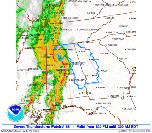
-
Going to be a fun night. Storms should rock through when everyone is sleeping in ATL.
-
Solak,
Big time wind damage event looks pretty likely for North GA. Looks like the whole forum is going to get some action this time. I read WxSouth who is honking Tornadoes but NWS says QLCS with wind damage due to north to south orientation down here.
-
2 hours ago, LithiaWx said:
Talked to my MIL again in Jenkinsburg. She did report some debris falling from that TDS. She made it sound like no big deal but I explained what she had witnessed. She was just off Shiloh road where the TDS was reported.
https://wgxa.tv/news/local/tornado-confirmed-in-butts-county
-
Talked to my MIL again in Jenkinsburg. She did report some debris falling from that TDS. She made it sound like no big deal but I explained what she had witnessed. She was just off Shiloh road where the TDS was reported.
-
 1
1
-
-
That was pretty eventful. Sure didn’t go down as I had thought. My mother in law lives in Jenkinsburg near Griffin where the TDS was reported. Not much of anything being reported out of there wrt damage.
Thats a spot is super unlucky. They got hit with EF3 on 4/27/11 and from the 1908 Dixie alley outbreak in April.
-
Windy night here in ATL. Beautiful 75 and breezy waiting for the bombs to drop....
-
Ridiculous dynamics setting up tomorrow over GA. Saving grace MAY be timing. I’m starting become more concerned about a morning round of nasty cells followed by a break and another shellacking in the afternoon for GA. Carolinas looks like much less impressive dynamics but possible better heating. Let’s hope everyone escapes the worst of it instead of all of us getting shelled. Those streakers posted above look pretty horrendous, all Over the forum. One nasty streak right over north metro ATL into SW NC.
I’m honing in on NE GA to SW NC as the bullseye tomorrow for the worst storms in the forum tomorrow. Let’s see how it plays out. It’s fun to track despite the dangers.
-
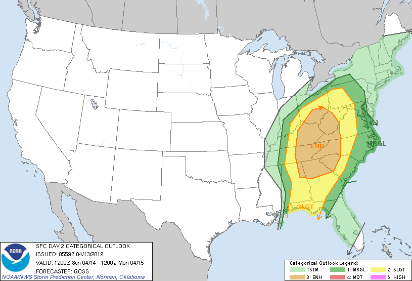
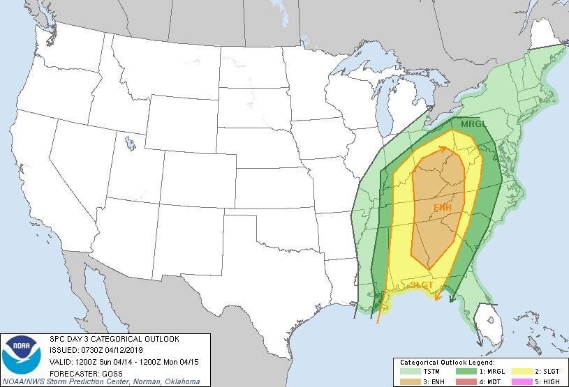
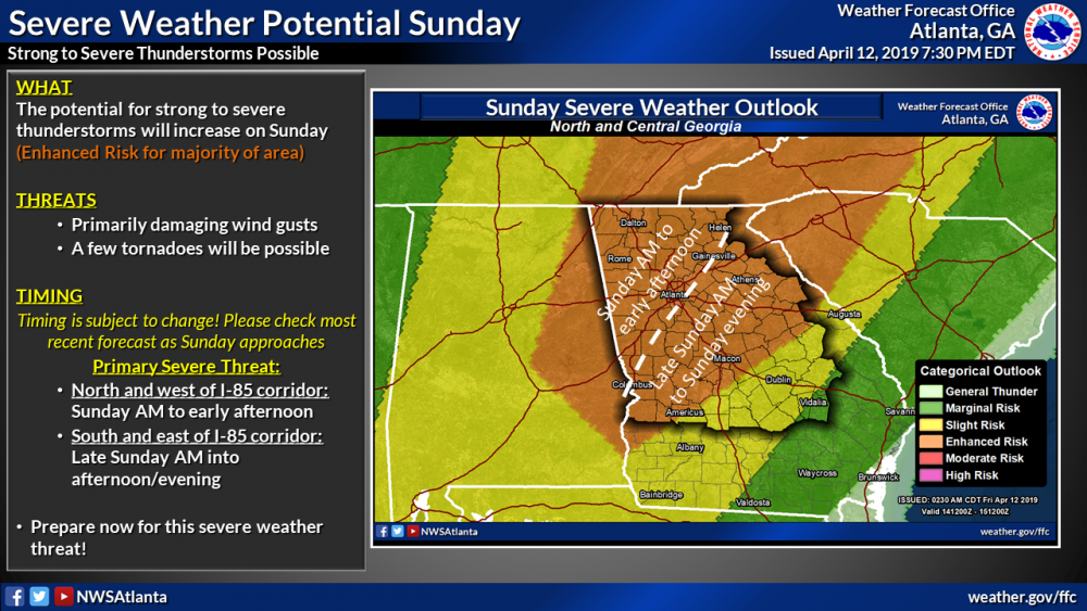
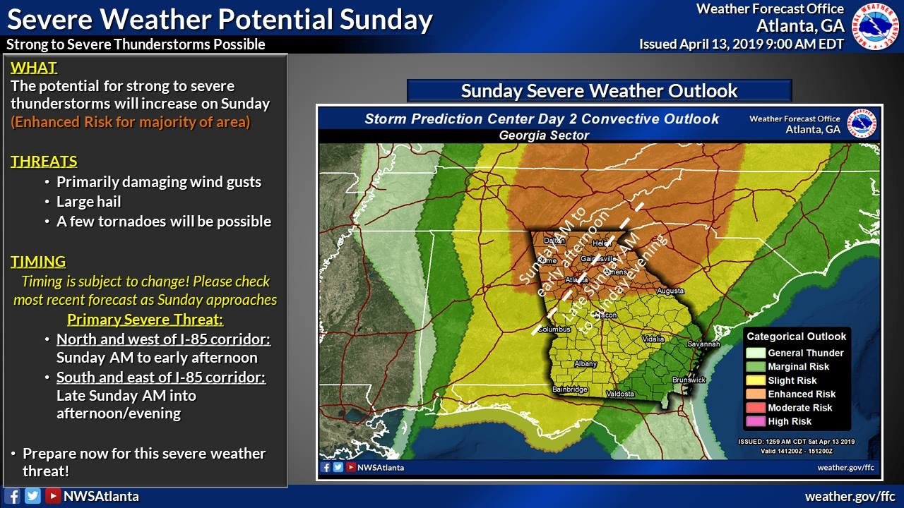
SHORT TERM /Tonight through Sunday Night/... Main focus of course on severe threat Sunday from potent frontal system and attendant impressive upper dynamics. SPC continues to have Enhanced Risk across north GA and Slight elsewhere, though any location in CWA could have some scattered severe storms. The first most likely prefrontal round would be pushing into the northwest as early as 12z then proceed eastward. Impressive shear in both deep and low layers ramping up after 15z with upwards of 500 m2/s2 of 0-1 km SRH. This combined with rather ample CAPE in 1000-1500 J/kg range will bring a threat to not only damaging winds in any bowing segments, but also brief spin-up tornadoes. Sig Tor Param is rather high in multiple models also in the 2-4 range. There is potential for a second round of convection firing off later in the afternoon closer to the front and still east of the upper trough axis. Will need to watch this as if mid level lapse rates do steepen, there could be perhaps some hail potential with the storms. Regardless of the storms, there will be enhanced gradient winds out of the south to SW and with sustained of near 20 mph gusting up to 35 mph, have warranted a Wind Advisory area- wide through Sunday. Cooler temps building in for Sunday night as things clear out from the west and most areas will fall into the mid 40s. Baker
-
-
8 minutes ago, downeastnc said:
About the only thing that will stop this from being a epic day is storm mode getting cluttered.....too many storms to close together could keep things from getting to insane, still looks like there will be no shortage of tornados to track....
Mentions of EF2+ and long trackers
-
1
-
-
 A significant severe weather outbreak is likely this afternoon into early Sunday morning. Tornadoes are likely throughout the entire region with some strong and long track tornadoes possible. Large hail and damaging wind gusts will be a significant threat as well. We advise everyone to stay weather aware this afternoon and overnight!
-
1
-
-
 ...Severe thunderstorms expected over parts of the East Texas to lower Mississippi Valley region later today and tonight... * LOCATIONS... Central and northern Louisiana West-central Mississippi East Texas Southern Arkansas Western Alabama * HAZARDS... Several tornadoes, a few intense Widespread damaging winds Scattered large hail, some baseball size * SUMMARY... Tornadoes -- some potentially strong to violent (EF2+) -- are possible today from east Texas to central Mississippi. Otherwise, numerous severe thunderstorms will pose a risk of large hail, damaging wind and tornadoes from central Texas this morning to the Tennessee Valley region overnight. Preparedness actions... Review your severe weather safety procedures for the possibility of dangerous weather today. Stay tuned to NOAA Weather Radio, weather.gov, or other media for watches and warnings. A tornado watch means that conditions are favorable for tornadoes to form during the next several hours. If a tornado warning is issued for your area, move to a place of safety, ideally in a basement or interior room on the lowest floor of a sturdy building.
 -
-
Day 1 - Saturday
Day 2 - Sunday
-
1
-
-
4 minutes ago, ryan1234 said:
Definitely, agree. However, if this thing speeds up, it might end up catching many by surprise. But this might up being one of those I-85 specials. If I were within 50 miles of 85, from just east of the AL/GA line to Charlotte and up to the Triad... I'd be ever so slightly nervous. Our area is well overdue for an outbreak.
I don’t care for the term overdue, but it’s true.
-
4 hours ago, ryan1234 said:
They make Saturday’s event seem more of an issue, than Sunday’s. That’s kinda surprising. Although, timing of the day may make it less of an issue than areas west of the Triangle. I definitely wouldn’t let me guard down anywhere in the Carolina’s for Sunday. It’s quite an impressive setup.
.
True, never let your guard down but from this map I see GA and WNC being the most under the gun in the forum. Dynamics must be much less impressive for central and eastern NC on Sunday. It could change but I bet NE GA and WNC have maximum heating and dynamics coming together. West Central GA may benefit from morning timing and escape the worst. That said with enough dynamics, timing in West Central GA won’t matter.
-
1
-
-
5 hours ago, kayman said:
Ironically this region is long overdue for an enhanced risk of severe weather and tornado threat. This idea of a cool air wedge always protecting North Georgia is silly. It's still in the Deep South, which is known for severe weather.
Looks like a wind event with some embedded naders. We will be on alert for sure.
-
Nasty storms incoming to metro Atlanta on Sunday. Looking pretty ominous now
-
1
-
-
Looks like a North GA snowstorm right there m. Yum.
-
Metro Atlanta is about to get trained. This should be fun. I’ve already seen a bunch of lightning.
-
 1
1
-
-
39 minutes ago, CaryWx said:
18z GFS came in warmer.
This sums up winter 18-19 pretty well

April 18, 19, 2019 Severe Event
in Southeastern States
Posted
925s are torching down here but upper levels support snow later today.
temps here’s in ATL will be falling all day. Pretty wild weather fo sho.