ValpoVike
-
Posts
634 -
Joined
-
Last visited
Content Type
Profiles
Blogs
Forums
American Weather
Media Demo
Store
Gallery
Everything posted by ValpoVike
-
I'll believe there may be a storm if it still shows early next week, but the GFS is overboard usually...especially at this range. I wouldn't take any of it verbatim.
-
It was a mixed blessing. We had 13 flash flood warnings during the Monsoon season, due to the burn scars. Are you up near Horsetooth?
-
Today marks the 1 year anniversary of Cameron Peak making it's final big run (and the start of my 3 week evacuation), as well as the start of the East Troublesome fire. What a difference a year makes. We actually had a decent monsoon up here this year, which was very fortunate as we were trending the same direction as last year before it kicked in.
-
We had 20 minutes of heavy snow and lots of lightning up here this evening. Love these October squall like conditions.
-
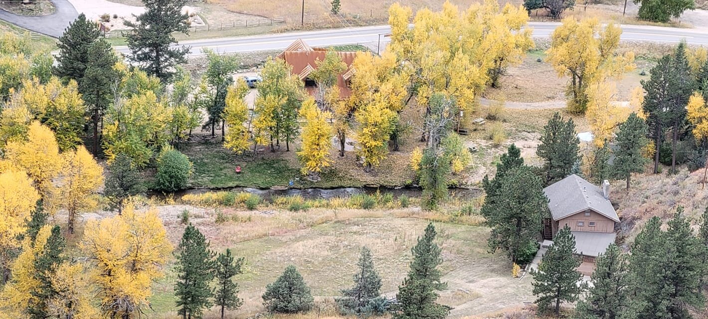
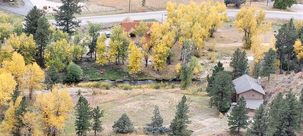
Just a few more days of color to go up here, but I did capture this yesterday looking down from my deck to the North Fork of the Big Thompson.
-
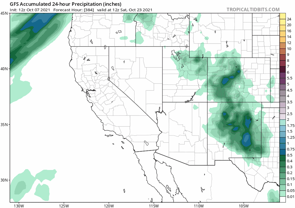
GFS is starting to show something way out at +384, which is a few days later...around the 22nd, with highest impact for NM. It will be interesting to watch this one as we move out of fantasy land.
-
I sure do enjoy reading your posts in the fall/winter/spring. You know it's definitely time to start that winter thread when Raindance is talking about Kamchatka.
-
Yeah, get that winter thread going. I actually had to fire up the heater this afternoon. Up here, sitting at a balmy 42 degrees and socked into the cloud deck with very limited visibility. It feels November'ish...
-
Not sure that one has much chance. Sam will leave a pretty good cold pool in it's wake, and even so it's recurve will allow anything that forms from that wave to rotate up and around the ridge. I think Sam is it for CV threats this year, imho.
-
The mountains have already had snow this year (a couple of weeks ago). For my area, ~Estes Park and Larimer county above 7k', I will predict Oct 7th. This is a very average date for us over the past few years. Last year was a very notable exception on Labor Day.
-
It looks like yesterday was good for a lot of areas. The hail scenes on the news were a bit interesting...fortunately it appeared to be mostly small hail but it did accumulate nicely.
-
Well, quite ironically....Phillips County in the far NE plains received up to 9" of rain last night.
-
I was just thinking last weekend that we have largely escaped large hail events this season. Sounds like that was a bit premature.
-
That sort of rainfall can indeed happen in Colorado, but with devastating effects. The 1976 Big Thompson flood is quite the example. From Wiki: On July 31, 1976, during the celebration of Colorado's centennial, the Big Thompson Canyon was the site of a devastating flash flood that swept down the steep and narrow canyon, claiming the lives of 143 people, 5 of whom were never found. This flood was triggered by a nearly stationary thunderstorm near the upper section of the canyon that dumped 300 millimeters (12 inches) of rain in less than 4 hours (more than 3/4 of the average annual rainfall for the area). Little rain fell over the lower section of the canyon, where many of the victims were. Around 9 p.m., a wall of water more than 6 meters (20 ft) high raced down the canyon at about 6 m/s (14 mph), destroying 400 cars, 418 houses and 52 businesses and washing out most of U.S. Route 34.[6] This flood was more than 4 times as strong as any in the 112-year record available in 1976, with a discharge of 1,000 cubic meters per second (35,000 ft³/s).
-
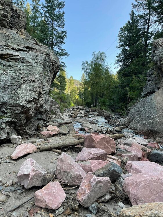
We got more this evening, about .3". It's crazy to see the feast or famine over the past 6 weeks. Regarding the boulders, this road is directly below a ridge that was burned in Cameron Peak fire last summer...hence the unobstructed flows coming down the mountain in the drainages. Burn Scar flooding is no joke we are learning, and it doesn't require a huge rain dump.
-
It's hard to be ungrateful for additional monsoonal moisture, but we've had enough up here. This photo is of Black Creek Road in our neighborhood. It is one of two county owned roads in the neighborhood, and Larimer has rebuilt it twice since July 4th. This is it's current state which is amazing and frankly hard to believe considering that most of the series of floods have been caused by events of an inch or less of rain. There are homes on this road, so not just a minor nuisance.
-
It's way too early to tell based on smoke forecasts, but given that Idaho and Montana have a lot of wildfires currently ongoing....I would expect those areas to be inundated. Wyoming would likely have more dependency on the smoke impacts from wildfires in neighboring states.
-
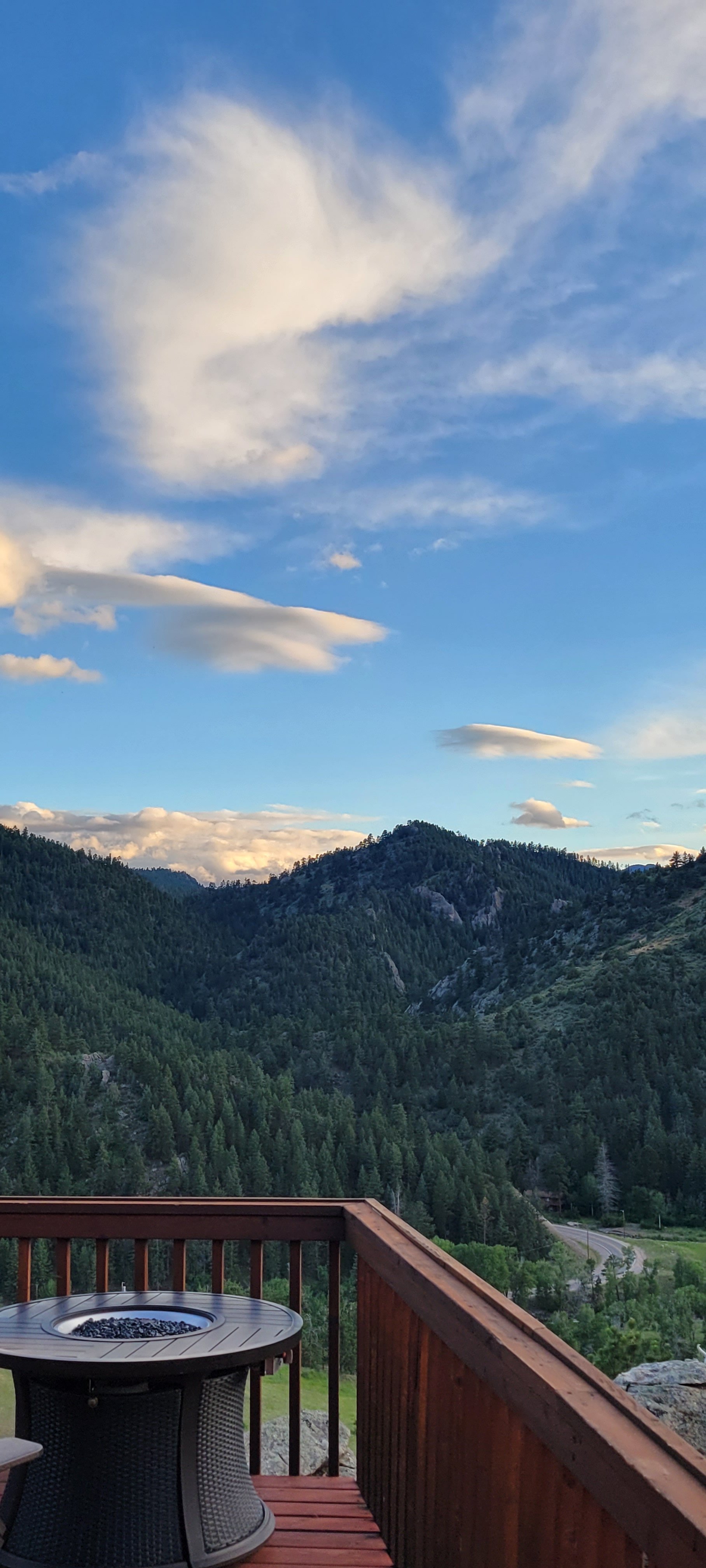
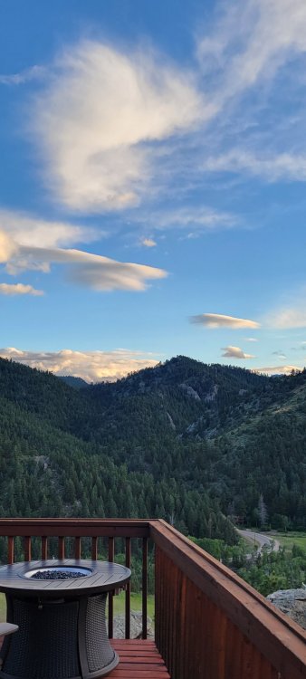
This morning the divide looks remarkably clear to my west. Fingers crossed that we get one day of semi-clear air. Between the days and days of rain up here and the days and days of smoke, we haven't seen any bluebird days in quite some time.
-
Yup and that is my neighborhood (The Retreat). We have been having burn scar flooding periodically since July 4th. We have already lost two roads in the neighborhood from crazy washout. Today was the roughest though. Several hours of rain today but it has stopped for now. The North Fork is fine but pretty full. It gets dicey where the Miller Fork meets it. Coal black water...
-
A tragic day of flooding yesterday on Hwy 14 along the Poudre River, in the Cameron Peak burn scar. This from the Larimer County Sherriff's Facebook page: I just returned from the Poudre Canyon flood incident that originated around Black Hollow Road, just west of Rustic earlier tonight. A resident from Black Hollow Road described a fairly typical rain coming down just prior to the flooding, which came down Black Hollow Creek. He said that the washing of soil and trees came as a complete surprise. We don’t have a definitive count, but it appears several structures along Black Hollow Road were damaged or destroyed. We do know that some residents did get out from that neighborhood safely. We are working from reports of three unaccounted for persons from that area. We have located one deceased victim in the area, but were unable to recover the body tonight. Those operations will be resume tomorrow morning. We also believe there may be two more people still missing from today’s flooding. A short distance west of Black Hollow Road, a significant amount of debris washed across Hwy 14, blocking the road. CDOT is working to remove that debris. I personally witnessed significant debris and damage in the area, caused by downed trees, damaged and destroyed homes and mudflow in the area. During this event, we evacuated the canyon- not knowing how this debris might impact persons and property downstream. Mandatory evacuations were lifted later in the evening. However, forecasts for Wednesday include the possibility for similar weather in coming days. The risk of debris flow damage remains and we caution any resident or visitors the canyon to remain vigilant. Our deepest sympathy goes out to the yet unidentified victim of this flooding and their family along with any other potential victims yet to be located. We cannot speak to the status of Hwy 14 as it falls under the authority of CDOT. However, we expect some level of travel restrictions as we resume recovery operations tomorrow. I want to thank all of the wonderful residents and visitors of the Poudre Canyon for their cooperation. I also want to thank all of the responders who have been and continue to be integral in our response to this tragic event. Those responders are absolutely amazing people!!! Our office will report more information as the details become more readily available.
-
2021 Monsoon part 2 on it's way today and thru the week. I am cautiously optimistic that we won't have the insane repeat of last years conditions. The two "long duration" fires, Muddy Creek and Morgan Creek, are not rapidly growing. Still a lot of fire season to go, but at least we are getting decent monsoons this year.
-
We got hit today by 3 strong cells. And we also got hit by the most specific flash flood warning I have seen, for only our neighborhood. The burn scars sent a nice wall of water down two streams and took out a couple of roads. It has rained for 9 out of the last 10 days now. This is the Larimer County Sheriff's Office with an emergency message. Dangerous flooding is occurring in The Retreat Area of Glen Haven. Streamside Dr and Fishermans Ln are the most impacted areas at this time. Immediately reach higher ground by any means necessary. Avoid area subject to flooding including dips, low spots, ditches, etc. and do not attempt to cross flowing streams or creeks. If driving, be aware that the road may not be intact under flood waters. Never drive through flooded roadways - turn around and go another way. If your vehicle stalls, leave it immediately and seek higher ground.
-
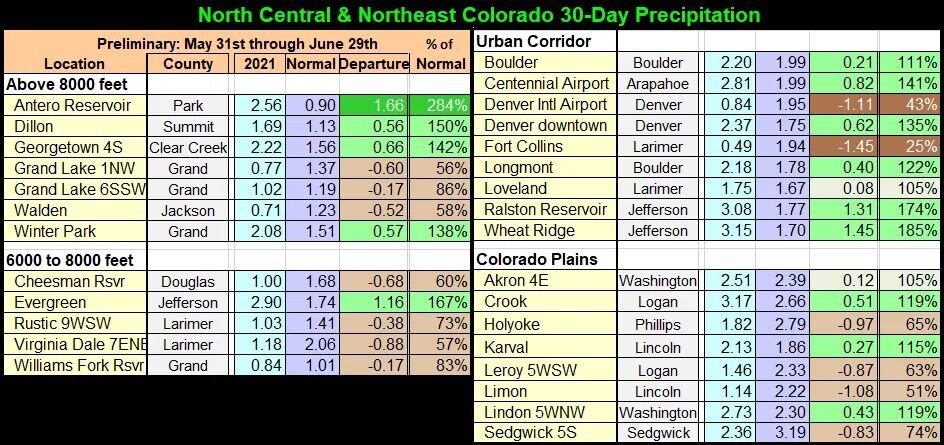
FoCo kinda stands out here:
-
Some Lenticular clouds starting to form. It is hard to tell from my vantage, but looks like it may be over Long's.
-
This moisture has been great to see. Rain every day since Thursday. Perhaps a bit too much on Saturday night when we had a rather long duration of several hours of moderate rain and we had some burn scar issues up here. We lost a portion of a road in our neighborhood due to a blowout upstream with debris flowing down. But I'll take that over last summer's relentless drought.