ValpoVike
-
Posts
644 -
Joined
-
Last visited
Content Type
Profiles
Blogs
Forums
American Weather
Media Demo
Store
Gallery
Everything posted by ValpoVike
-
Yeah pretty meh. I did get about 5” but that is far short of the 7-12 forecasted. This has been typical all season in my neck of the woods. Fortunately we have nickled our way to a not too bad winter though. I do hope we get the March dumps this year.
-
Ratios can be frustrating here. Personally I use 10:1 as I have seen too many storms with much higher predictions miss terribly.
-
Great grab. I have been admiring that cloud all evening. It is spectacular.
-
It is good to see snow in the SE corner though. They are in D2-D3 still.
-
Yeah a snoozer but seems to happen more often than not in early January. I did spend the week in Santa Clara on business and got the full rain experience. It was crazy.
-
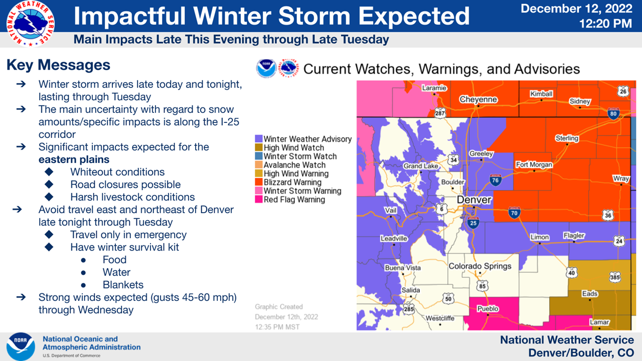
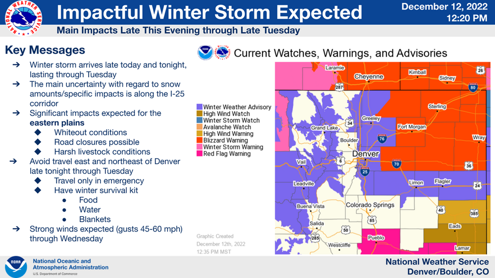
And a very broad avalanche warning that includes the entirety of the northern foothills. Definitely some questionable watches and warnings today.
-
31 degrees and very decent snowfall rates up here in south central Larimer county. The snow has a high moisture content as well.
-
I think part of the issue is a lack of consistent data due to some stations reporting real-time while others in preset intervals. I could be wrong though.
-
We ended up over achieving to forecast up here as I recorded a low of -17 this morning. Thankfully winds are very light. Ended up with about 3.5” of snow overnight.
-
Up here it is a balmy +5 with a refreshing 7mph breeze. And only have seen pixie dust. Not gonna complain if the forecast miss trend continues though.
-
Looks like the I25 corridor is now getting into the action. The foothills look to miss out.
-
Not a bad event up here in the Larimer county foothills. I ended with 6.1” which is right at the midpoint of the forecast. Really cold today too!
-
I think the ratios were the issue...as Chinook mentioned at 10:1. I had been hearing as high as 25:1 being expected, and while very early in the day the ratios seemed high...it quickly transitioned to pixie dust.
-
Pretty underwhelming up here, just under 3" compared to 6-12 being forecasted. But I'll take any snow
-
Up here in the Larimer foothills, I received about 3". A bit of a disappointment as I was hoping for 4-5, but still very welcome. This storm was however the "winter driving pipe cleaner"....the storm where people apparently have to re-learn how to drive on snow. Even with such light accumulation, Estes Park was overloaded with accident reports and 36 was closed due to numerous slide-offs.
-
Yeah same here. Took a vacation trip to Virgin Islands and missed our first snowfall. good to see snow though.
-
Here we go, it will eventually snow. Some snow starting to creep into the forecast for 10/24 for the Front Range, which is the system that the GFS sniffed out at 240h.
-
Yeah, it's crazy. Long's Peak did have some snow a couple of weeks ago, but it melted quickly. Up here at ~7300' daytime highs have been relatively normal, but we have not had a freeze at night either. Forecast shows 33 tomorrow/Sunday night though...so perhaps.
-
Still in fantasy-land, but the GFS thinks that it may be time to start up a winter thread in the last week of October.
-
Yeah, fall is happening!
-

2022 Atlantic hurricane season whining/banter
ValpoVike replied to GaWx's topic in Tropical Headquarters
Just a casual observer to the Tropical threads, but I have noted a sharp decrease in activity from ldub. -
You should have gone to bed early last Monday, unfortunately. I bet you are looking forward to LE snow season though. I lived in Chardon for 8 years and I miss the insane dumps.
-
What, no view like this in Ohio? Wondering where this webcam is located though....perhaps somewhere in Wild Basin. It's a great perspective view.
-
Well, bummer! On the bright side - you may actually see snow in Ohio
-
It has been the second weird summer monsoon in a row....where up here we are hoping for only light rain, showers or storms have been coming several times a week, and the grasses are still green. While elsewhere outside of certain spots in the foothills could use as much rain as possible. The exact same thing happened last year.