ValpoVike
-
Posts
609 -
Joined
-
Last visited
Content Type
Profiles
Blogs
Forums
American Weather
Media Demo
Store
Gallery
Everything posted by ValpoVike
-
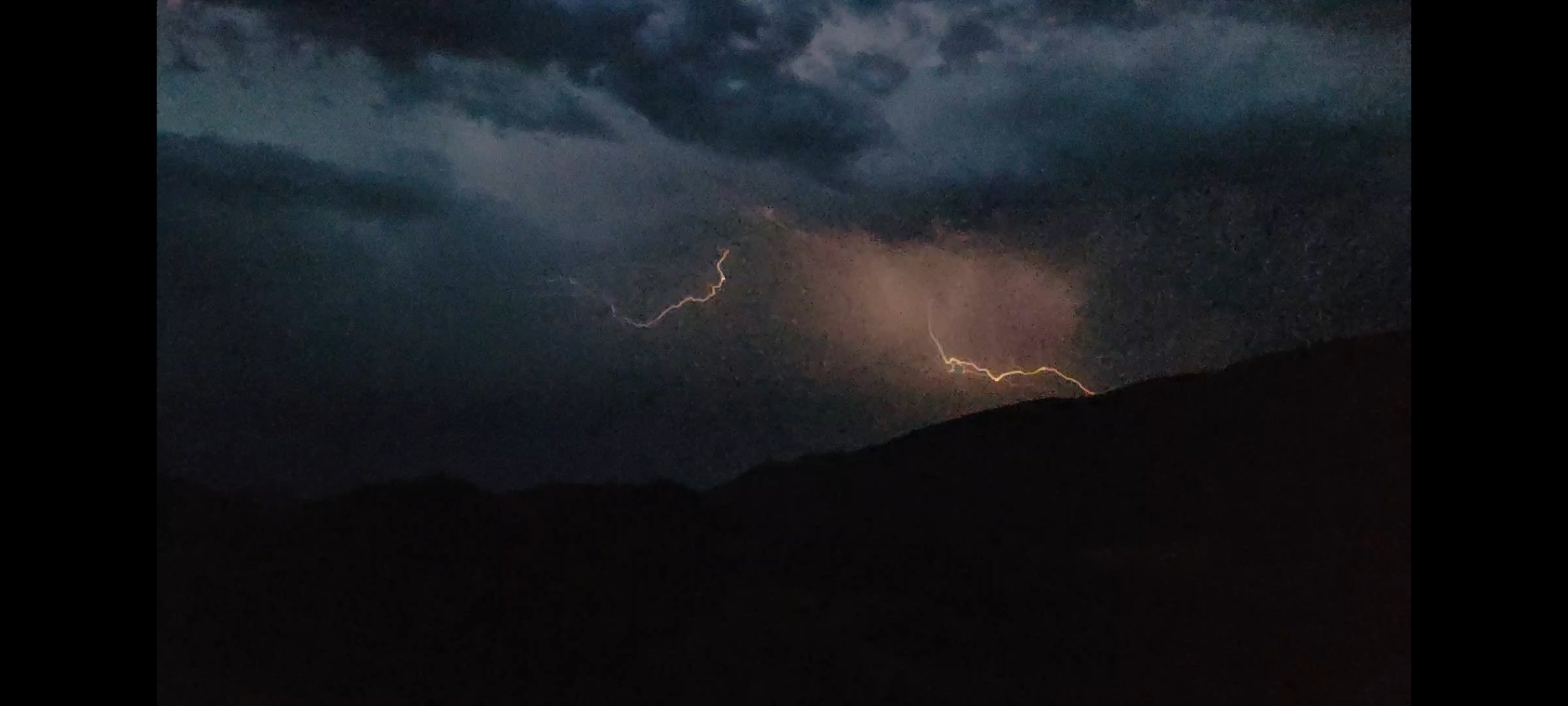
I shot this off my deck this evening. This is looking east towards Loveland.

-
I watched the radar loop on this on Sunday, and it was the oddest storm motion that I can recall. It stumbled like a drunken pirate...moving northeast, then west, then a very sudden about-face to move east before dissipating. The anvil was a beautiful site from up here though.
-
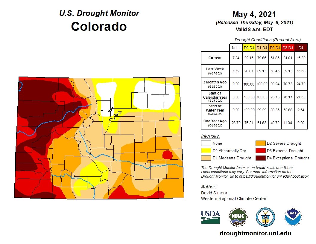
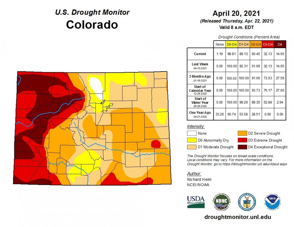
A typical summer pattern so far the past week. Up here in Glen Haven we thankfully have had good short lived heavy rain the past couple of days, but that is just by luck as most of the front range has not seen these. You're spot on that it comes down to the monsoon. Western Colorado is still in a rather dire scenario that the monsoon won't fix.
-
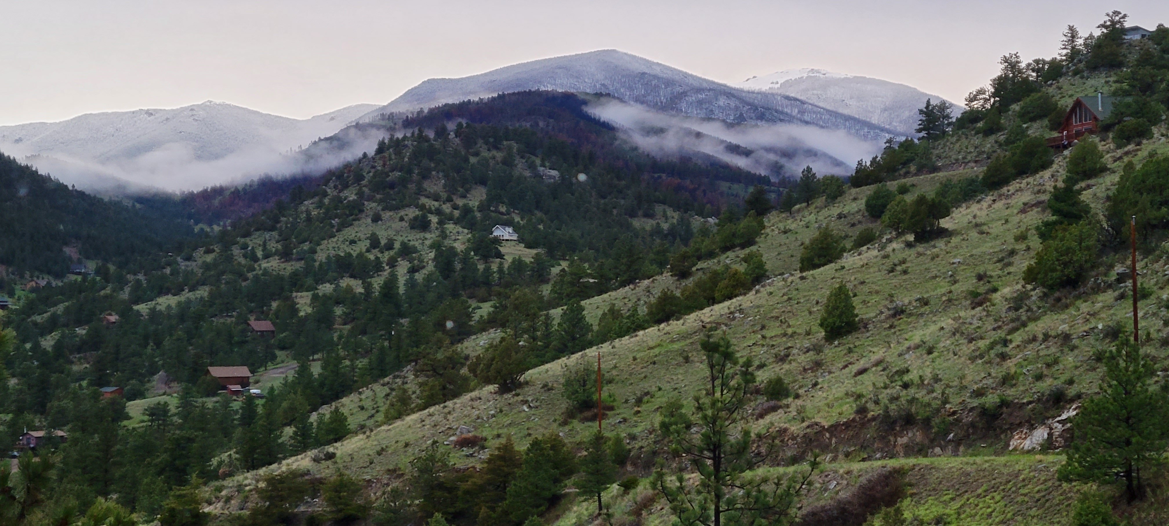
That is a cool photo. Below is a photo of fresh snowfall that I shot yesterday/Sunday evening from my deck looking west up the North Fork of the Big Thompson. Signal Mtn is on the right and Mt Dickinson to the left, with Mummy Mtn off camera a bit further left. Right of center are some burn scars from the Cameron Peak fire which have been quite useful in revealing snow coverage from a couple of miles away. Anyways, it is stunning out with all of the green popping out everywhere with the backdrop of fresh snowfall.

-
This year GFS = Generously Forecasting Snow
-
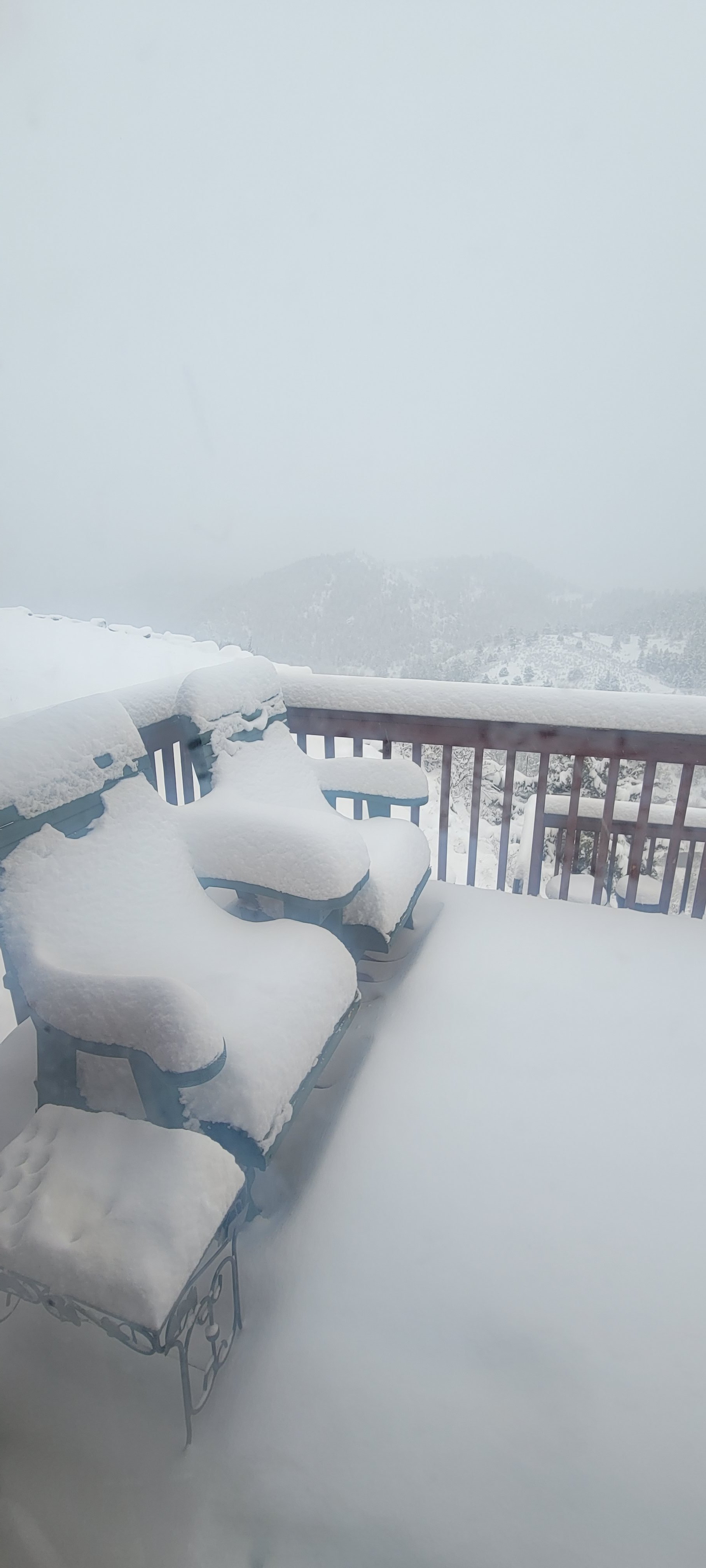
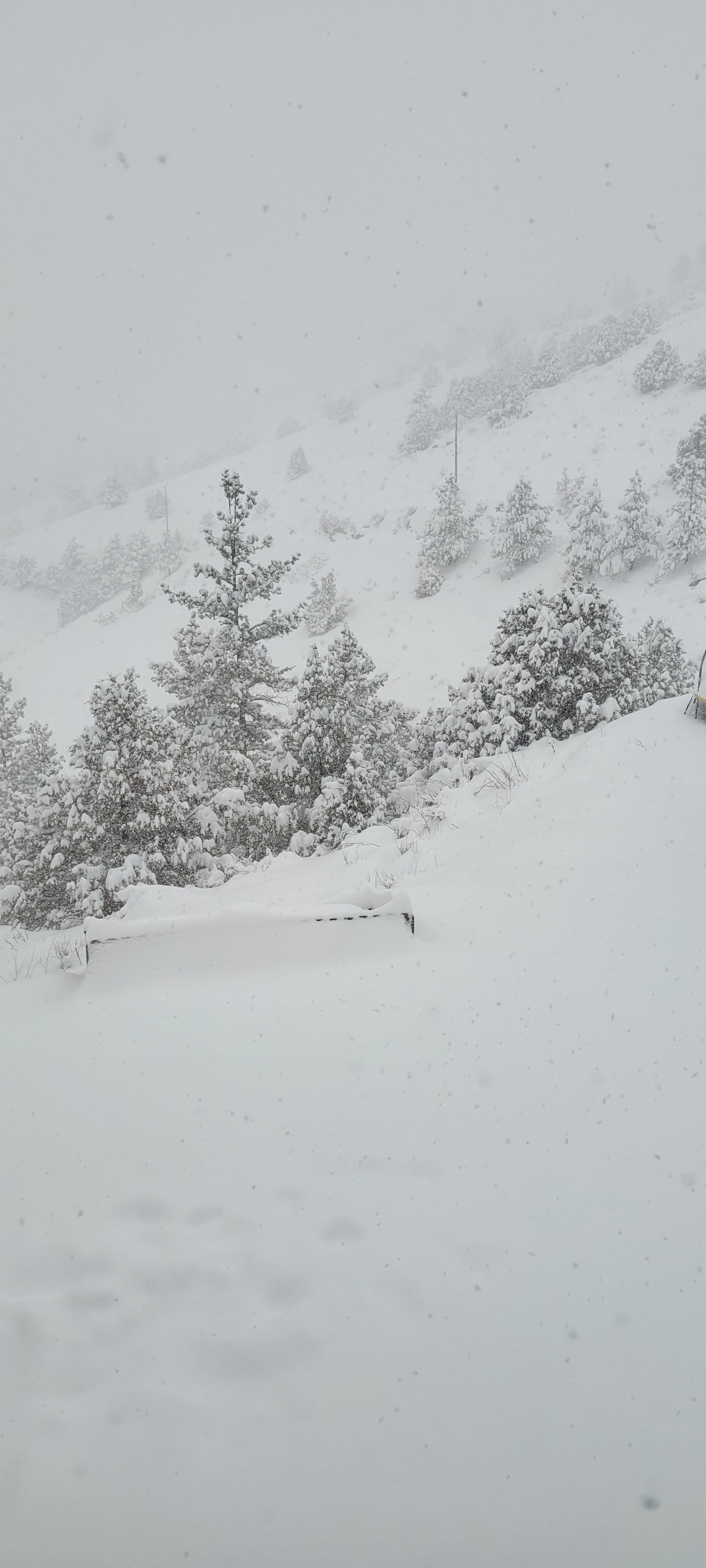
Not too bad up here. Woke up to about 2" this morning, that melted by noon despite steady snow. It started accumulating again in the early afternoon and we are probably back up to 3" of new accumulation. It's not really accumulating on road surfaces, just on decks and grass. All in all a very typical May snow.
-
Yet another juicy storm on tap for early this week. I think this makes the 3rd "early in the week" storm in a row with generous QPF. This one feels a bit more interesting with respect to snow accumulation. It looks like 6500 feet and higher may do pretty well this time around, versus the 8000 foot consistency in the prior two weeks. Not that I am pulling for 10-12" up here, I'm kind of done, but I think it is possible.
-
Here ya go. Very good improvement over the northeast.

-
I came across this from NWS Boulder's Facebook.
-
I'm not sold on this. I think it will end up a lot like this week's storm....good for the mountains but a melty mix for lower elevations. Perhaps I am wishcasting a bit as I am really ready for winter weather to end . I am at ~7300' and my home is surrounded by 9k'+ mountains....this week was interesting as I could see a clear snowline just over my head, probably around 8k'
-
Feels to me like timing for a spring summer thread is just about right.
-
It really comes down to the Monsoon. We were in great shape exiting snow season last year, but no monsoon. Raindance, do you happen to track analogs for the regional monsoon season?
-
Well, at least some good news for portions of Larimer and Boulder counties.
-
Maybe after tomorrow a fork can be put in with models pointing to a few inches on Wednesday. But the NWS says - Meh. Up here we have had a pretty good season, though I honestly have no idea how much total snowfall has occurred. We even picked up some surprisingly good snows on Labor Day and again in late October. March and April have been good to us as well. In between was underwhelming. I'm ready for snow season to end too, and also hoping that the Monsoon actually shows up this year. The lack of a real monsoon last year seems to me to be what drove the massive fires last year.
-
We have done pretty well this week.

-
It's been a steady nickel/dime event up here in Glen Haven. About 3" on Tuesday, and about the same amount again yesterday evening and night. The road surface melting in-between has been welcome...so bring on the moisture! I did have a hairy experience on the switchbacks north of Estes on CR43 where a layer of ice had formed under a layer of snow Tuesday evening, that was not fun at all as my Jeep nearly hit a guardrail despite crawling down at 5mph.
-
The precip is going to be spread out over most of the week, and temps will be quite marginal. I think snow that does accumulate will melt fairly quickly, and especially down in the lower elevations there will be more mix and periods of straight rain.
-
Yeah, Larimer and Boulder counties get hammered by the "new" GFS.
-
Both the GFS and Euro are showing some impressive QPF and snow early next week for the front range,. Temps really look suspect though, and it will be interesting to see how this plays out.
-
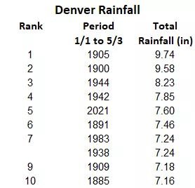
Last weekend's storm did wonders on catching most of the Northeastern CO region on seasonal snowfall. From the NWS this morning, contrasting seasonal totals prior to the storm and totals following the storm:
-

Front Range snowstorm nowcast/conditions 3/13-15
ValpoVike replied to mayjawintastawm's topic in Central/Western States
Picture time. Looking out from a window, Glen Haven...looking NW.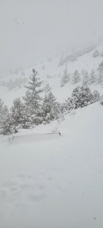
-
Front Range snowstorm nowcast/conditions 3/13-15
ValpoVike replied to mayjawintastawm's topic in Central/Western States
I was reading that apparently a Denver cyclone formed overnight and created a downslope for y'all. -
Not sure about in town at EP, but so far not bad north of town. I was hoping for 40"+ this weekend, but it doesn't feel like we get there. Maybe we exit today at 30-32"...which is still great. It depends on when the spigot shuts off obviously.
-
Front Range snowstorm nowcast/conditions 3/13-15
ValpoVike replied to mayjawintastawm's topic in Central/Western States
19" so far IMBY, and estimating about 12" of that fell after midnight. Kind of hard to tell how much more today...HRRR is looking crazy high on additional QPF, but it looks like the moisture train to the east is drying for points north. EDIT - that is, for northern Colorado. -
Front Range snowstorm nowcast/conditions 3/13-15
ValpoVike replied to mayjawintastawm's topic in Central/Western States
I live in Glen Haven. About 6 or 7 miles north of Estes.