ValpoVike
-
Posts
658 -
Joined
-
Last visited
About ValpoVike

Recent Profile Visitors
4,699 profile views


-
I am at 0.71” total. On Monday the QPF for me was forecasted to land just under 1.2”. Starting to rain again and temp has dropped to 38.
-
I am at 0.24” for the day from several passing showers. Nice to see this playing out.
-
I am with you on the optimism. I am also growing more optimistic on seeing the season's first snowflakes up here at my location, given the pretty sharp downward trend in temp guidance. I'm not expecting any accumulation though.
-
I saw that too and smiled. There is a near zero chance this verifies, but it is the first fantasy land storm of many for the season. I am cautiously an optimist for this winter.
-
I believe it will be location bound. From I25 east may be normal to slightly above, while the central and southern mountains may end up with a much above normal snowpack. But all in all, very likely a big improvement over last season.
-
I take model timing details with a grain of salt for mountain locations.
-
Yesterday I took a trip up in RMNP to the Alpine visitor center at the top of Trail Ridge Road. I took the "back way" via the Old Fall River Road route, and it rained nearly the entire way. Once at the top, the temps plunged to the mid-30's with sleet and snow showers. When I made it back down to Estes Park, it was around 70 and sunny. I love this time of year .
-
It’s quite safe going up. It is a well maintained dirt road but not nearly as exposed As TRR. All the way up you will drive about 10MPH and there is an excellent waterfall and meadows that line the river. It is a canyon that you drive up, and you are surrounded by incredibly majestic rock formations that extend up way above you. It is also one-way and much more chill than TRR.
-
Are you here on vacation? I live just outside of Estes Park, and Trail Ridge Road is really special. For an added experience, you can go up a one way road (Old Fall River Road) that exits at the Alpine Visitor Center at the top. You then take TRR back down. I have seen snow falling at the top in both July and August many times. Not much but enough to remind you just how high up you are.
-
Congrats to you guys in the south metro. We greened up over the past 3 weeks, which is crazy my pasture is never green in mid-August. The models seem to be indicating another round of moisture later this month, but we'll see. Beyond that, I am anxiously awaiting to see what winter will bring with such a strong El Nino.
-
That’s a bit surprising as it has looked like the south metro has done well today, minus the large hail reports of course. I was hoping that you and Majya picked up some good totals today. Up here, much more gentle rainfall with .16” so far. Not going to complain as we have been doing well since the first monsoon rounds a few weeks ago. In fact, we have seen a resurgence of a green up which is unusual.
-
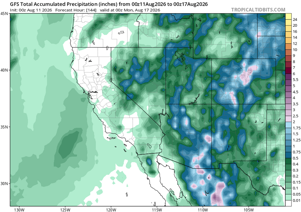
I really don’t know what to say guys, trends are quite positive for the front range. Crawling back from a drought in the western states is exactly that, crawling. Anyways here is the QPF forecast thru Sunday. Euro is somewhat similar but about half of the amounts.
-
The model trends are looking good for Thursday thru the weekend. Not sure that I trust the QPF forecast fully, but it is becoming likely that many of us get nice totals.
-
Wow, and I thought that it was dry'ish up here... I am at 9.19" YTD. Even then, I know that the big snow dump we had in May overwhelmed my Davis' precipitation hopper as the total from that event came in pretty light. I think perhaps around 10" YTD is more accurate.
-
Flood warning for central Douglas county for up to 3" have already fallen. Congrats Smokey! Moving north to my backyard, we have a flood advisory. Picked up a very fast 0.60" and still coming. My July total just crossed 3", with >95% of that over the past 10 days.