pasnownut
-
Posts
10,320 -
Joined
-
Last visited
Content Type
Profiles
Blogs
Forums
American Weather
Media Demo
Store
Gallery
Everything posted by pasnownut
-

Central PA - Winter 2020/2021 Part 2
pasnownut replied to MAG5035's topic in Upstate New York/Pennsylvania
wiggle room....lol -
Central PA - Winter 2020/2021 Part 2
pasnownut replied to MAG5035's topic in Upstate New York/Pennsylvania
Germans showin love to the forum for next Tuesday. Bellied under and nice transfer....all snow. as we are looking for consensus, i think we now have ICON Euro and GFS all in similar camps (staying under us - no cutter). Hoping that theme continues to gain traction.... -
Central PA - Winter 2020/2021 Part 2
pasnownut replied to MAG5035's topic in Upstate New York/Pennsylvania
Ask and ye shall receive. -
Central PA - Winter 2020/2021 Part 2
pasnownut replied to MAG5035's topic in Upstate New York/Pennsylvania
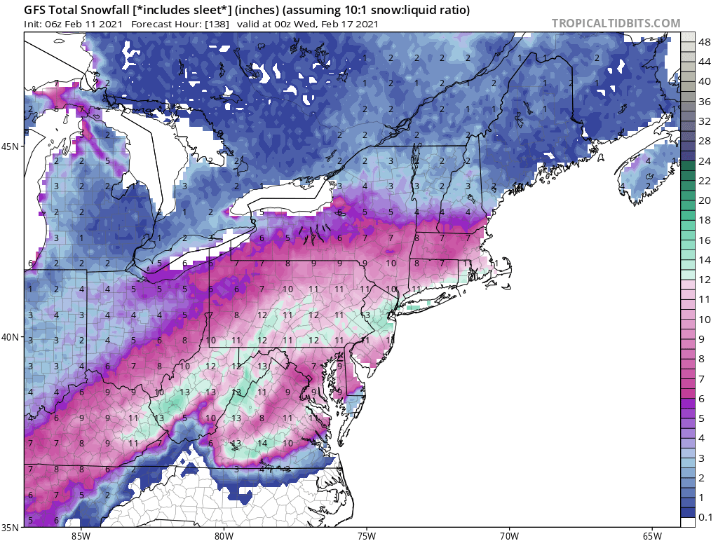
BTW, everyone in the southern tier should go look at the 6z GooFuS snow maps through end of run for purely entertainment purposes. I'd post, but I don't want anyone to think less of me than they already do. -
Central PA - Winter 2020/2021 Part 2
pasnownut replied to MAG5035's topic in Upstate New York/Pennsylvania
ICON is a skating rink down here in LSV for Sat event. Shows rain, but 2m temps in mid 20's throughout event. verbatim....we skate. Snow wise, its a bubbles to Voyager special IMO. -
Central PA - Winter 2020/2021 Part 2
pasnownut replied to MAG5035's topic in Upstate New York/Pennsylvania
I always do and it usually verifies pretty well. Hard part is the deliniation between frozen varieties but like I said earlier, as long as i dont have green above me.....I'm ok w/ whatever -
Central PA - Winter 2020/2021 Part 2
pasnownut replied to MAG5035's topic in Upstate New York/Pennsylvania
yeah i saw that. Scratchin my head a bit as i though the shredder was runnin outta gas. Might set up Tuesdays potential a bit better..?? Dunno -
Central PA - Winter 2020/2021 Part 2
pasnownut replied to MAG5035's topic in Upstate New York/Pennsylvania
nah, more like good at some things....just like any other model. If there's one we should trust more this year, I wouldnt know which one it is. -
Central PA - Winter 2020/2021 Part 2
pasnownut replied to MAG5035's topic in Upstate New York/Pennsylvania
seeing that pawatch got 1.5" is a win as well so the north bump was legit....just not the lofty totals that we saw. Stored in memory bank for further use. -
Central PA - Winter 2020/2021 Part 2
pasnownut replied to MAG5035's topic in Upstate New York/Pennsylvania
uh oh....Ahoff is lurking again...... he's in here looking to steal more of our forums snow........ J/K hope you did well yesterday. -
Central PA - Winter 2020/2021 Part 2
pasnownut replied to MAG5035's topic in Upstate New York/Pennsylvania
NAM's get a lot of trashing, but like you I think they are a good to use as well. They tend to overdue qpf as we all know, but seem to do well w/ thermals and where the qpf is going to fall. edit - and they suck at what kinda frozen one is getting. For me....all I care about is pink/purple/blue.....hate green -
Central PA - Winter 2020/2021 Part 2
pasnownut replied to MAG5035's topic in Upstate New York/Pennsylvania
with all that said.....bolded is all he really worries about. -
Central PA - Winter 2020/2021 Part 2
pasnownut replied to MAG5035's topic in Upstate New York/Pennsylvania
Thats great to hear. As we've seen quite often, the extreme cutters of the past have seem to hit some resistance thanks to our Canadian friends. Belly under baby....belly under. At last look, tellies would support more souther solutions for next week. Gonna have to see where things are headed beyond that. -
Central PA - Winter 2020/2021 Part 2
pasnownut replied to MAG5035's topic in Upstate New York/Pennsylvania
Looking at that map.....NO thanks!! Sheesh thats alot of ice. -
Central PA - Winter 2020/2021 Part 2
pasnownut replied to MAG5035's topic in Upstate New York/Pennsylvania
Bet on 11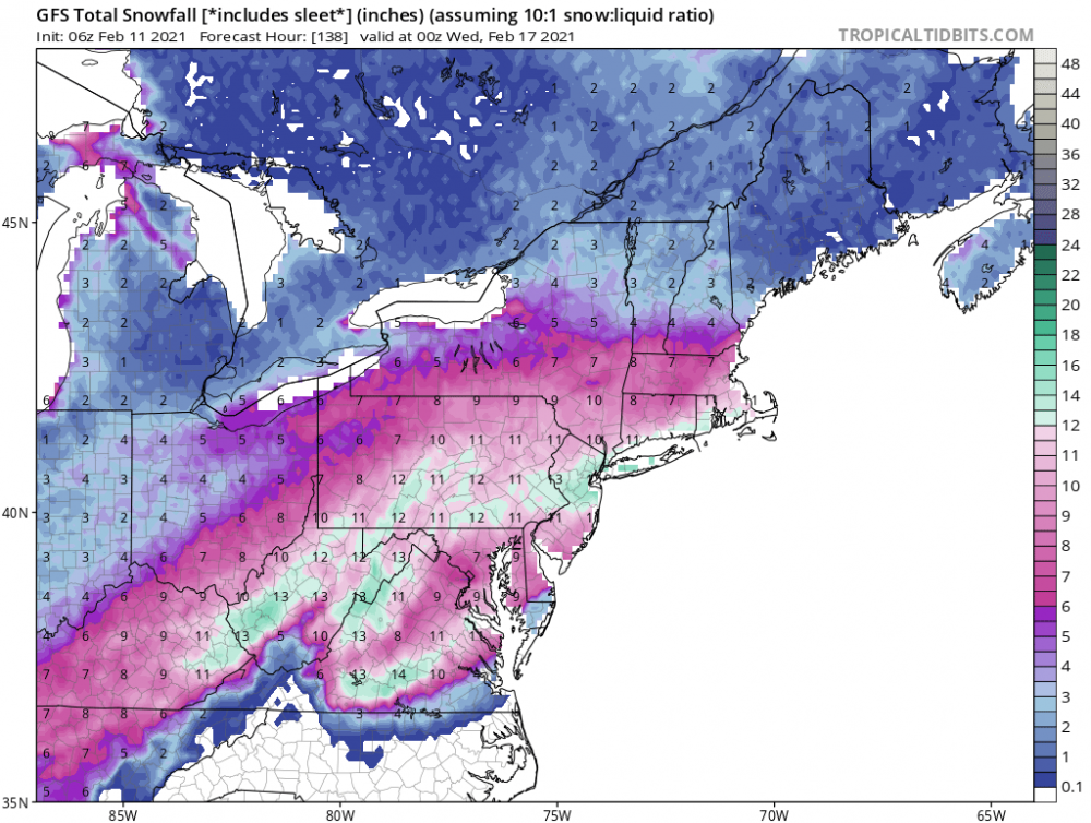
-
Central PA - Winter 2020/2021 Part 2
pasnownut replied to MAG5035's topic in Upstate New York/Pennsylvania
06z gfs comin around for early next week. Liking the progression. Couple moves away from a good one. Hope it continues. currently pixie dust falling -
Central PA - Winter 2020/2021 Part 2
pasnownut replied to MAG5035's topic in Upstate New York/Pennsylvania
Light snow here in Lanco. Looks like 2-2.5” ish here. Will take a better measurement when I go out for wood. -
Central PA - Winter 2020/2021 Part 2
pasnownut replied to MAG5035's topic in Upstate New York/Pennsylvania
0z NAM did trim back as I expected. Still feel 2-4” is a safe bet here. Band out wast looks pretty stout. Just need it to hold together. -
Central PA - Winter 2020/2021 Part 2
pasnownut replied to MAG5035's topic in Upstate New York/Pennsylvania
Still waiting. Hoping for 3-4” here in Lanco. good luck all. -
Central PA - Winter 2020/2021 Part 2
pasnownut replied to MAG5035's topic in Upstate New York/Pennsylvania
Lol. Didn’t watch it. -
Central PA - Winter 2020/2021 Part 2
pasnownut replied to MAG5035's topic in Upstate New York/Pennsylvania
Who’s Otis no really. yeah I’m old. -
Central PA - Winter 2020/2021 Part 2
pasnownut replied to MAG5035's topic in Upstate New York/Pennsylvania
Welcome. Glad to have you join in on the fun. -
Central PA - Winter 2020/2021 Part 2
pasnownut replied to MAG5035's topic in Upstate New York/Pennsylvania
dude its all good. You had a hunch and it didnt work out.....this time. I've got a bunch of recipes for crow if you need some. Don't know anyone here that hasn't tasted it and in fairness you throw a lot of stuff out there (like myself and others), so its bound to happen. I think many appreciate those of us that are willing to chat storms up and what we think will happen. Its all good. Enjoy your "surprise" snow. -
Central PA - Winter 2020/2021 Part 2
pasnownut replied to MAG5035's topic in Upstate New York/Pennsylvania
Lol's. Back when I participated more frequently in the MA forum, they called it "atmospheric memory" or something along those lines. Thats partly my take on the constant N jog we see. OTOH we've been seeing cutters belly under and yeah, that's been my hope as the cold air should be stable enough (not transient), thats my hope wrt next weeks pair of events, that they can belly under and not attack the cold dome. I'll be watching the progression in hopes that suspicions verify. -
Central PA - Winter 2020/2021 Part 2
pasnownut replied to MAG5035's topic in Upstate New York/Pennsylvania
that's a hard YES. I'm so hip. I'm really glad it took the nutsack off of my house. lol