

CentralNC
-
Posts
532 -
Joined
-
Last visited
Content Type
Profiles
Blogs
Forums
American Weather
Media Demo
Store
Gallery
Posts posted by CentralNC
-
-
Just now, PantherJustin said:
“Our last Bust of the year 2021” Thread
I LIKE that!
-
 2
2
-
-
5 minutes ago, PantherJustin said:
If it’s still there Feb 26th can we start a Thread? Lol
Yes but don't put MAJOR in the title!
-
2
-
 2
2
-
-
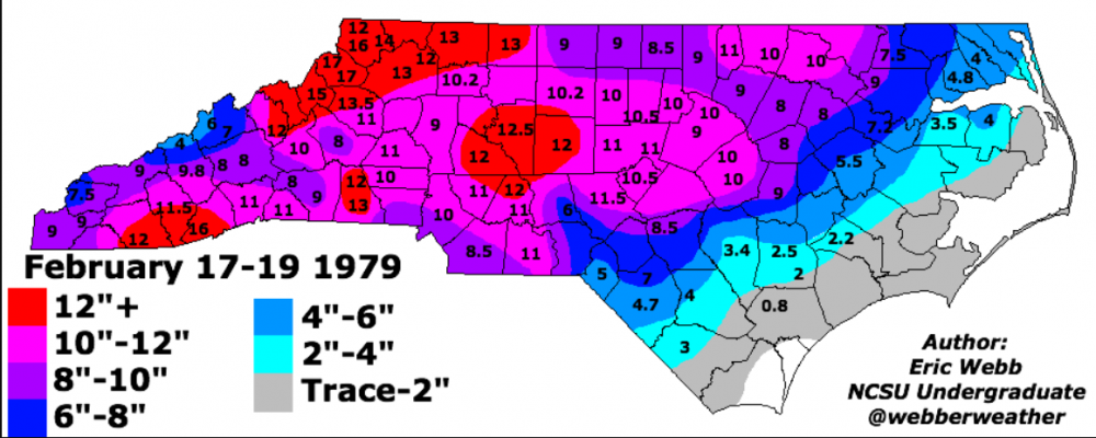
On this date in 1979, one of my favorite storms. You want cold air? Snow started right before dawn and temps fell from the low 20's to the low teens by early afternoon. Some blowing and drifting. Of course this is known as PD1 and it was spectacular. Watched from my dorm room in Salisbury in complete awe.
-
13 minutes ago, Met1985 said:
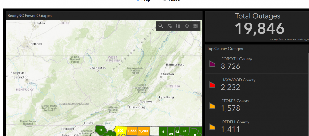
Yeah Haywood got hit pretty good. I know Duke energy and Haywood EMC are working several calls for power being out. I have to admit I was completely wrong on this one.
Don't feel bad. Most on this forum were..
-
2
-
1
-
-
Oh no, we suck again
-
32 still with ZR/IP mix. Definitely more than last weekend thus far. Trees droopy but not too bad
-
32 with ZR. At this point we have about as much glaze as we ended with last weekend. Looks like a couple more hours of it (perhaps). Not going to be devastating here by any stretch.
-
1 hour ago, kvegas-wx said:
Waking up to a rather unimpressive and splotchy radar and only 32° in Kvegas? Not what I thought I was signing up for but I'll take it! Barely a glaze so far unless my 6am eyes are failing me.
Bustogenesis in process.
-
Just now, wncsnow said:
Pretty big fail setting up here. No heavy precip and still 33.3.
Yep, pretty clear to me that heaviest ice totals will be in VA border counties unless I am missing something.
-
3 minutes ago, HKY1894 said:
18z HRRR is a crush job along the escarpment in northern mountains as well as big ice amounts from hickory to gso. Hope QPF is overdone as depicted is devastating
.The way most of these work out is there is a fairly narrow strip where the WORST of the icing is. Widespread .50 ice and up is hard to achieve. That strip is to be determined but based on precip trends, I would say NW piedmont and northern foothills of NC if I was a bettin man.
-
1
-
-
6 minutes ago, msuwx said:
I posted this a couple hours ago...
”This is my map, prior to the mid-morning model guidance arriving. I reserve the right to adjust if necessary later today. As usual, the area of highest uncertainty is at the fringes of the sub-freezing air, which unfortunately includes the CLT and RDU metros.
Those in the red-shaded area especially, be prepared for the potential of power outages. Once you start getting ice accumulations above 0.25", the power grid begins to experience failures.“
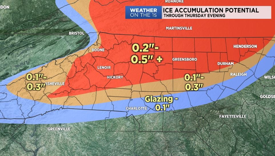
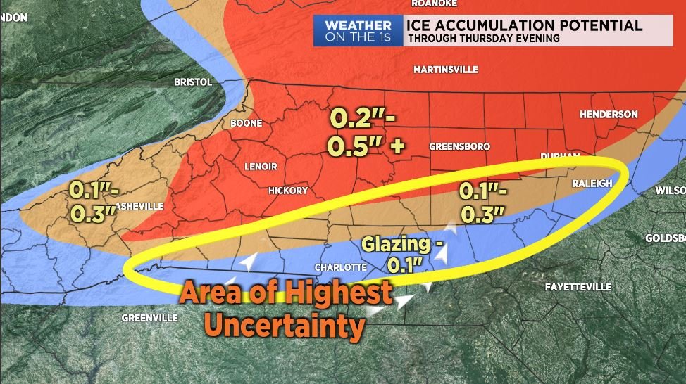
Thanks Matt. Going to be a rough situation for a bunch of north carolinians.
-
 1
1
-
-
13 minutes ago, olafminesaw said:
At this point, it's equally important to track dewpoints and cloud cover throughout the day as it is to look at the models. Right now dewpoints are running a degree or two higher than the NWS forecast and some high clouds are moving towards the piedmont.
Not sure a degree or two matters that much at this point in the piedmont but for fringe areas for sure. Still a lot of dry air draining down from VA.
-
2
-
-
20 minutes ago, SUNYGRAD said:

I was in the heart of that one. Was more of an in-situ damming situation and precip came just as the right time. There was literally no wind with that one. Still I lost power and lots of tree limbs. Was pretty bad by W-S standards.
-
1 minute ago, srobby76 said:
Long time follower of these events and most have fallen apart on us, with that being said would yall cancel a training for people driving to Durham from the triad and Triangle for thursday and Friday. I have to decide today to prevent any charges for cancellations.
Just my opinion, but major roads will more than likely be just wet, but as it usually goes for me is people have trouble getting out of neighborhoods due to hazards. If it was me, I would cancel.
-
1
-
-
Just now, jburns said:
Be careful what you wish for. The coldest freezing rain event I have ever been in was 19º at its peak.
Yeah should have said "only if it cools aloft too" !!
-
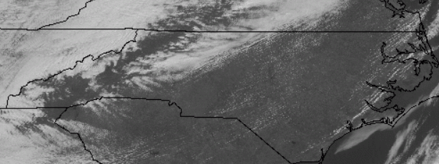
Most of the state in the sun....but not the triad.
-
Just now, NorthHillsWx said:
Significantly colder than 00z for sure
I am still holding out (some) hope that sleet will save me at my location at least to some degree. But little doubt there will be a sizable chunk of real estate with ZR issues. Seeing models trend colder does not hurt my feelings one bit!
-
1
-
-
2 minutes ago, Ghicks said:
im in nw nc mount airy near va border and no kind of watches for me and im fine with that. not a ice fan.. which who knows what will occur here
You almost certainly will be in a Winter Storm Watch with the afternoon forecast packages. I don't think Surry escapes this one.
-
1
-
-
Just now, Blue_Ridge_Escarpment said:
The triad begs to differ. Was 30-31 most of event and was pretty significant.
Agree, GSO was 30-32 entire event and they got .25 in a lot of places. Key was it did not fall too fast allowing accrual.
-
3
-
-
6 minutes ago, NorthHillsWx said:
Crazy to think it’s been 4 days locked in the 30’s with precipitation each day but not a single flake.
For the Wednesday/Thursday event, it looks like the same areas will get hit. Retreating HPs mean areas outside the absolute max CAD regions will quickly go to rain. Also, just like last event, 32 does not mean efficient freezing rain especially with the gigantic and deep warm nose above the ground. I agree another significant ice storm looks likely and it may very well have the same footprint as last time. Never forecast against climo for marginal ice events. I’ll speak for myself and the rest of us in the Triangle who have seen more 33 degrees and rain in the last week than anyone would like to see in a lifetime: please kick this pattern please
Here ya go.

-
1
-
1
-
-
6 minutes ago, tarheelwx said:
Probably getting close to 1/4” on trees here.
TWI think Guilford will be the worst hit of the triad counties. Not that bad here in western Forsyth.
-
2
-
-
Just now, HoosTC said:
NWS RNK AFD at 11:30
With regard to tonight, significant icing is expected as the
baroclinic zone lifts a bit northwest in response to upper
ridging off the southeast/Mid-Atlantic coast. Warm air aloft
will support mostly rain across these areas with temperatures
below freezing as the wedge holds in tough overnight. Ice
accumulations of 1/2 to 1 inch appear likely and possibly more
east of the Blue Ridge where current plans are to go with a
Winter Storm Warning and a Winter Weather Advisory to the west.
More on that later this afternoon, but a serious icing event
looks probable for areas like Danville, Lynchburg, South Boston,
and other cities in this general area. Stay tuned for updates
forthcoming this afternoon.
Not surprised. Prime location with continue low DP air filtering down from NVA.
-
2 minutes ago, rxUNC70 said:
Long term lurker, first time poster. No better place to start here to vent about what a shit-tastic pattern this is. Love me some 33 degrees and rain for three days!!
For all the hype about how great the NAO/AO indices have been, the pattern in the Pacific really screwed us. To add insult to injury it has been a very wet pattern. I need to hire someone to drain the swamp that has taken over my back yard.The weather gods can be cruel for us SE folks. On a brighter note at least the ski resorts have had a good winter so far. If it wasn’t for the blocking pattern, it would have been a different story.
Welcome aboard. We all suffer together...
-
2
-
-
1 minute ago, BornAgain13 said:
Whats weird is they have counties just to my NE under a Winter Storm Warning lol
I guess because Ice Storm Warning is so specific, maybe they wait until later packages to throw that one out there. You're a good candidate.
-
1
-


Winter 2020-2021 whining thread
in Southeastern States
Posted
I think it's on to next winter. It just ain't happenin this year. Hopefully we have all learned a lesson about these models this year.