
Thundersnow12
-
Posts
11,414 -
Joined
-
Last visited
Content Type
Profiles
Blogs
Forums
American Weather
Media Demo
Store
Gallery
Posts posted by Thundersnow12
-
-
Still manages 6-10" across immediate Chi metro. Alek's call somehow still alive
-
 1
1
-
-
GFS looks like a slight bump north with the early snows
-
5 minutes ago, ILSNOW said:
Is RC more optimistic then Joe?
He is
-
15 minutes ago, ILSNOW said:
and of course 12z RGEM comes north

Beautiful, really helps bring to life the Joe/RC battle
-
1
-
-
Central Illinois absolutely buried. Unreal. Someone send this to the kid at LOT.
.thumb.png.4d0e28a30b3c6789eeb846ae5e4cd32e.png)
-
Just now, Chicago Storm said:
12z NAM will bump south with the main storm.
Sizable changes across the Western US with the main trough.
.Well it's been fun. Will take my advisory of upslope snows out here and call it.
-
2 minutes ago, mimillman said:
A cluster at 5-10” and a cluster at 15-20”. The 5-10” cluster seems reasonable.
It'll compact down to 3"
-
 1
1
-
-
Nothing like a good 0-25" spread on the plumes for ORD
-
3
-
-
8 minutes ago, Chicago Storm said:
agree.
that’s not a new thought either. have been hedging south for two days now, and Ricky can confirm.
.Thought I heard you say mixing issues creeping into Alek’s backyard
-
What a run. And it’s snowing all the way back to the plains associated with the main ejecting wave which is across the TX PH at 84hr.
-
3z plumes jumped again
Mean of 13” at ORD with a cluster in the 4-10” range and then another cluster in the 13-18” range
-
Euro with a slight bump NW with the early overrunning snows compared to 18z
-
7 minutes ago, snowman33 said:
For GHD II, the Euro was south around this time.
Did I make that euro QPF gif? Lol
-
43 minutes ago, RCNYILWX said:
I think GFS did pretty well for GHD II, did it waver less farther out than ECMWF? I do recall the ECMWF started honing in on the more extreme QPF/snow output. The stronger surface low was a pretty late detail in the forecast that led to us issuing the blizzard warning.
Sent from my SM-G998U using Tapatalk
You could be right. I’d have to go back and look. I just remember always making gif comparisons of Euro QPF from WxBell showing the bumps north.
-
3 minutes ago, Hoosier said:
Would be curious to go back and look at the NAM/GFS runs ~3 days prior to GHD I and II
NAM was very amped for GHD I, GFS was solid IIRC
I want to say both were south for GHD II and baby stepped slowly north. Euro led the way with that one.
Speaking from a Chi metro standpoint, that area was in the bullseye fairly early and for much of the time with GHD I while GHD II was more reeling it in
-
2
-
-
That looks like close to 36” in east central IL to NW IN, north of LAF
-
Extrapolating, the NAM is probably a 20” event for Chi metro
-
The wave coming ashore BC/Pac NW continues to trend coming ashore further SW which seems to be really helping this play out favorably
-
2
-
-
Through 48hr, looks like little more ridging and little more vorticity advection. Would guess bump north incoming
-
1
-
-
4 minutes ago, sbnwx85 said:
For the record I work at one of the tv stations in South Bend (in the news department…not a met) and I’m happy to say it’s not this station.
Good lord some TV Mets are dumb
-
1
-
-
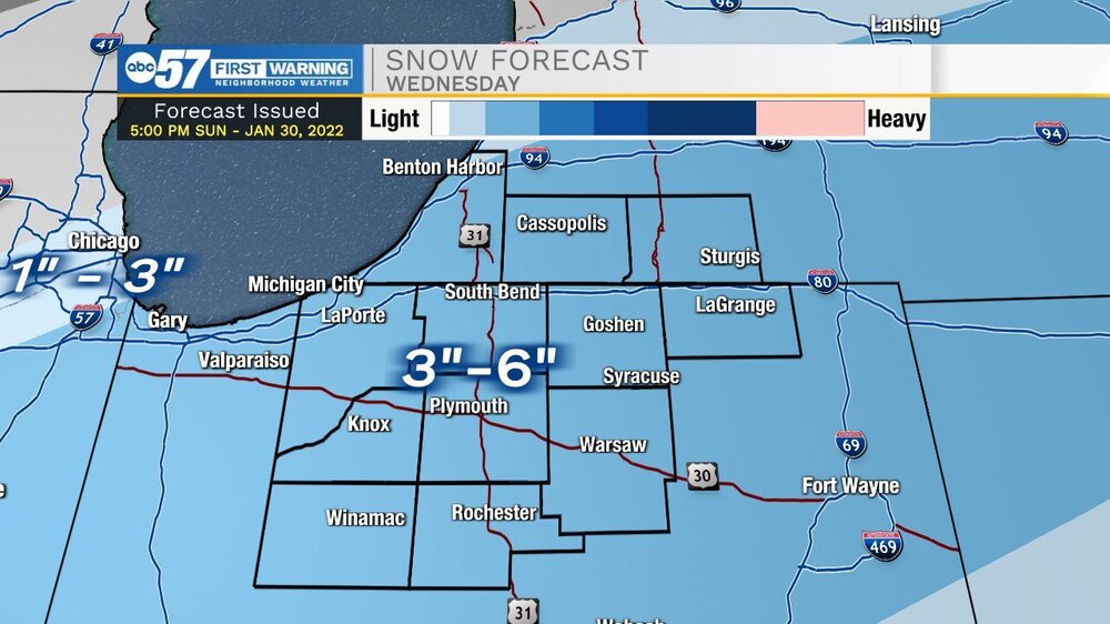
6 minutes ago, Sciascia said:
ABC7 Chicago put out a map. I would’ve waited a day or so to avoid the “You only said 3-6 inches!” crowd if models keep bringing it north.

Leave it to Phil Schwartz to pull this sh*t.
-
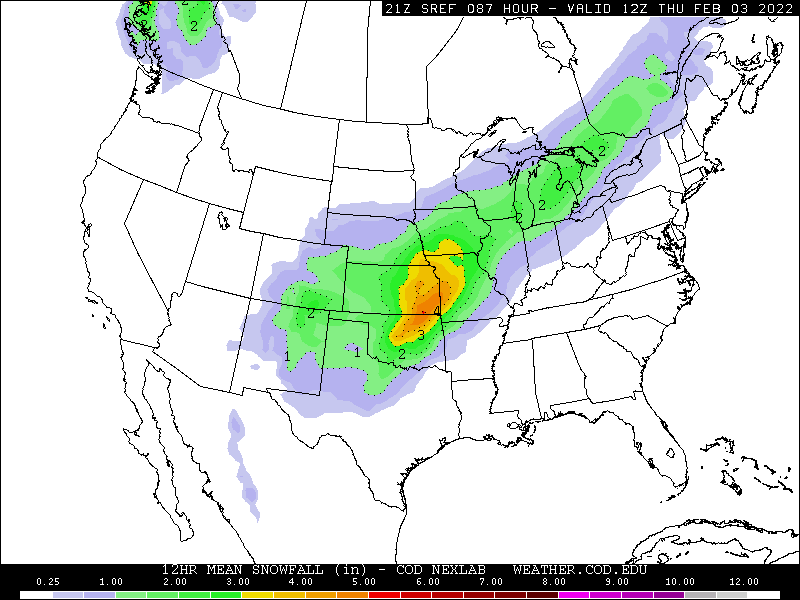
End of the 21z SREF mean snow looks pretty NW with the main ejecting wave snows.
-
4
-
-
18z Euro with a little bump north with overrunning snows through 72hrs and little snowier in heart of axis
-
FWIW the 15z SREF initial snow axis was close to right through Chi metro so north of other guidance
-
 1
1
-
.png.7a06ffc8d8d12e34e49dcb4abbd79337.png)


Feb 1-3rd GHD III Part 2
in Lakes/Ohio Valley
Posted
Torching in the upper 50's out here.