
Thundersnow12
-
Posts
11,414 -
Joined
-
Last visited
Content Type
Profiles
Blogs
Forums
American Weather
Media Demo
Store
Gallery
Posts posted by Thundersnow12
-
-
Fire everyone at NCEP when the foreign models get this one right
-
 1
1
-
-
41 minutes ago, Cary67 said:
GFS and NAM caving to weaker drier SE solution. Mchenrysnow and I need to move to DTW for snow. Weather is repetitive
1" far NW LOT, 3-6" metro, 4-7" southside over to DTW
How are either of this caving to a weaker/drier solution?
-
3 minutes ago, ILSNOW said:
0z Kuchera for McHenrysnow that 25 is for you!!!! (if only)

Geos magnet turned on
-
 1
1
-
-
GFS also ticking slower again
-
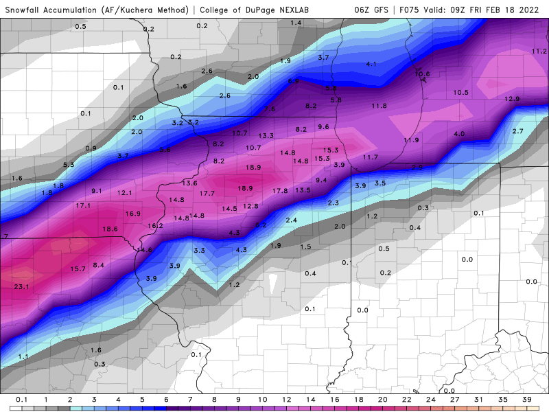
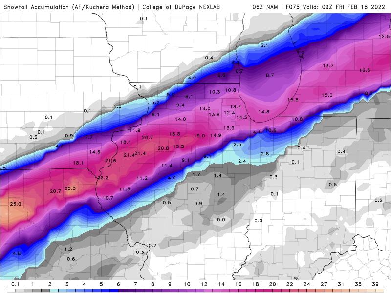
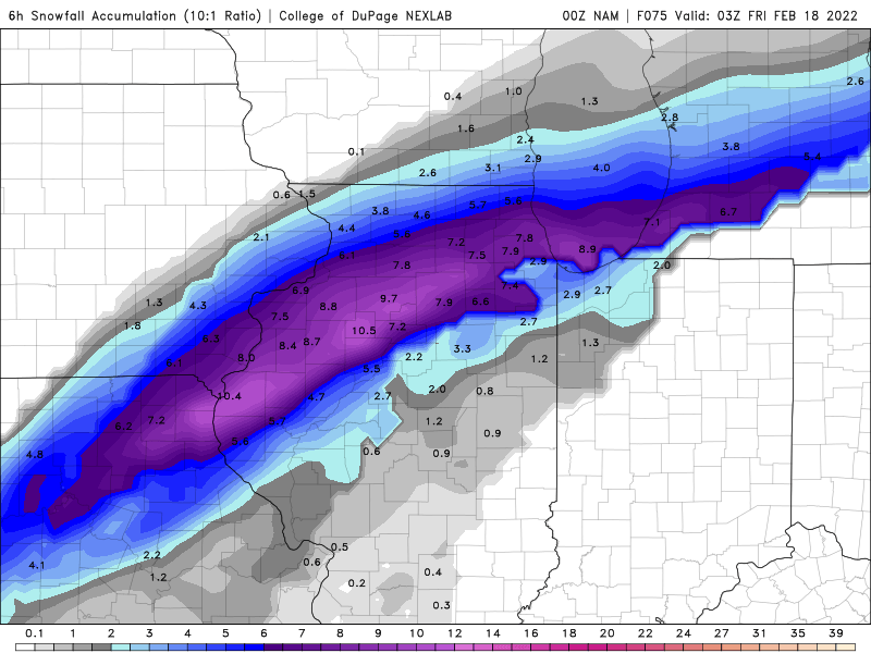
The 6hr totals map even at 10:1 is pretty wild
-
2 minutes ago, Chicago Storm said:
The former. Crusher.
-
2
-
-
4 minutes ago, Chicago Storm said:
NAM will either be north, or end up going big earlier and shearing out faster.
Really cranks quickly once it ejects and goes negatively tilted
-
7 minutes ago, Chicago Storm said:
We’ll have to watch that trend.
It was something that was seen with GHD3 in the days leading up to it. Guidance overcorrected in that case, and then ended up coming back faster once again.
The other potential would obviously be for it to keep trending slower, which then could cause other issues
.
-
Early look at the NAM is it's going to be slower again
-
6 minutes ago, A-L-E-K said:
Plumes not exactly hot
Mean swath bumped SE and also looks drier compared to the 15z run
-
 1
1
-
-
12 minutes ago, AWMT30 said:
And the RAP did quite well once we got inside 51 hours.
If you're talking about GHD III that's a no. The RAP had multiple runs of 12-18" for the Chi metro area. It like the HRRR was too far NW for multiple runs.
-
4 minutes ago, Hoosier said:
18z Euro news?
Slight bump north with the heart of the swath but also slight downtrend to totals in it
-
SLP looks weaker/slower to deepen
-
Hot run for sure. 0.25-0.50” ice for Chi metro (Ricky’s fav) then buried
-
2
-
-
20 minutes ago, Chicago Storm said:
definitely not the winter trend.
.And it's only 3 runs at a day 5+ range lol not really a large sample size
-
56 minutes ago, A-L-E-K said:
0 with the miss south final call
Ride the hot hand after the last one
-
2
-
-
2 hours ago, Baum said:
"IT IS A SYSTEM
WORTH KEEPING AN EYE ON. "- Gino Izzi.Reeks of I hate snow but I'm obligated to write this haha love Gino
-
1
-
-
10 hours ago, A-L-E-K said:
well that was fast
Poor Joe
-
1
-
-
Just under 3" in Downers Grove
-
1.4” at LOT and 1.5” in Downers Grove is def ahead of schedule. Good sign
-
8 minutes ago, Dalfy said:
Maples' rough estimate of changeover- Jefferson, MO and metro. 1-4am sounds right and earlier than Canadian guidance by 10-12 critical hours. I don't think I'll be able to sleep monitoring this haha:
.AVIATION...  (For the 06z TAFs through 06z Wednesday Night)
Issued at 1040 PM CST Tue Feb 1 2022

A high impact winter storm is imminent with a broad area of
precipitation stretching from central Illinois southwestward
through a large portion Missouri. Rain transitioned to all snow at
KUIN around 02z this evening with the transition affecting KCOU
between 03z and 04z. Following shortly behind will be KJEF around
the release of this update. Metro terminals will likely follow
between 07z and 10z.
Hey Joe, your boy Maples! Joe is his biggest fan.
-
1
-
-
1 minute ago, ILSNOW said:
Is that 27 the home of ALEK
Prime jeb walking conditions
-
2
-
-
1 minute ago, Chicago Storm said:

Hopefully LOT is awake and adds another tier of counties to the warning. Writing is on the wall now with this steady trend.
-
0z RAP also is NW across Chi metro through 12z tomorrow
-
 3
3
-
Feb 16-17th Winter Storm
in Lakes/Ohio Valley
Posted
Don’t mess with the king