
Thundersnow12
-
Posts
11,414 -
Joined
-
Last visited
Content Type
Profiles
Blogs
Forums
American Weather
Media Demo
Store
Gallery
Everything posted by Thundersnow12
-

Central/Western Medium-Long Range Discussion
Thundersnow12 replied to andyhb's topic in Central/Western States
Yeah I gotta say I'm getting pretty excited for how our trip (5/15-5/24) is looking right now. -
Central/Western Medium-Long Range Discussion
Thundersnow12 replied to andyhb's topic in Central/Western States
He will also be going above normal for the week to follow that as well. -
Central/Western Medium-Long Range Discussion
Thundersnow12 replied to andyhb's topic in Central/Western States
The CFS is changing run to run and even isn't in line with the GFS/Euro. Victor Gensini and myself are heading up trip 2 with CoD and we leave 5/15 and we both think it looks quite good at this stage and are very optimistic. -
Alaska/Western Canada obs and discussion
Thundersnow12 replied to patrick7032's topic in Central/Western States
another beauty off the coast of BC -
Alaska/Western Canada obs and discussion
Thundersnow12 replied to patrick7032's topic in Central/Western States
awesome picture to clearly see the snow level. -
Alaska/Western Canada obs and discussion
Thundersnow12 replied to patrick7032's topic in Central/Western States
awesome vis sat view of the big system off the coast of BC -
Alaska/Western Canada obs and discussion
Thundersnow12 replied to patrick7032's topic in Central/Western States
good lord that is an awesome picture. -
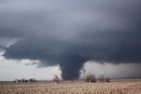
Historic Tornado Outbreak April 27, 2011
Thundersnow12 replied to CUmet's topic in Weather Forecasting and Discussion
here is the image I saved of the 240kt g2g couplet....just amazing. -
Historic Tornado Outbreak April 27, 2011
Thundersnow12 replied to CUmet's topic in Weather Forecasting and Discussion
happen to catch who? I'd be curious if it was one of the forecasters or someone higher up. -
Historic Tornado Outbreak April 27, 2011
Thundersnow12 replied to CUmet's topic in Weather Forecasting and Discussion
unconfirmed report of a school gone along with houses leveled around it in the Manchester/Warm Springs, GA area. -
Historic Tornado Outbreak April 27, 2011
Thundersnow12 replied to CUmet's topic in Weather Forecasting and Discussion
-
Historic Tornado Outbreak April 27, 2011
Thundersnow12 replied to CUmet's topic in Weather Forecasting and Discussion
not good...180kt delta v with a velocity hole...looks like the tornado will go between all 3 towns. -
Historic Tornado Outbreak April 27, 2011
Thundersnow12 replied to CUmet's topic in Weather Forecasting and Discussion
both with over 110kt g2g -
Historic Tornado Outbreak April 27, 2011
Thundersnow12 replied to CUmet's topic in Weather Forecasting and Discussion
432 tornado warnings today -
Historic Tornado Outbreak April 27, 2011
Thundersnow12 replied to CUmet's topic in Weather Forecasting and Discussion
The horizontal vortices with some of the tornadoes today are absolutely amazing.. still amazed we saw a 240kt g2g couplet today. -
Historic Tornado Outbreak April 27, 2011
Thundersnow12 replied to CUmet's topic in Weather Forecasting and Discussion
This needs to be a rude awakening for others, and more so people that live in big cities. This is going to happen in Chicago, ITS going to happen and people here are not ready for a violent tonado. -
Historic Tornado Outbreak April 27, 2011
Thundersnow12 replied to CUmet's topic in Weather Forecasting and Discussion
-
Historic Tornado Outbreak April 27, 2011
Thundersnow12 replied to CUmet's topic in Weather Forecasting and Discussion
holy debris ball... -
Historic Tornado Outbreak April 27, 2011
Thundersnow12 replied to CUmet's topic in Weather Forecasting and Discussion
190kt g2g...debris ball is crazy -
Historic Tornado Outbreak April 27, 2011
Thundersnow12 replied to CUmet's topic in Weather Forecasting and Discussion
-
Historic Tornado Outbreak April 27, 2011
Thundersnow12 replied to CUmet's topic in Weather Forecasting and Discussion
170kt g2g now with a velocity hole had 209 g2g the previous scan.. -
Historic Tornado Outbreak April 27, 2011
Thundersnow12 replied to CUmet's topic in Weather Forecasting and Discussion
240kt g2g....dear god....strongest ever? -
Historic Tornado Outbreak April 27, 2011
Thundersnow12 replied to CUmet's topic in Weather Forecasting and Discussion
OMG at that motion! wow -
Historic Tornado Outbreak April 27, 2011
Thundersnow12 replied to CUmet's topic in Weather Forecasting and Discussion
just some numbers right now in central/northern AL 0-6km shear of 60-80kts 0-1km SRH of 600-1000 m2/s2 SBCAPE around 3000 j/kg with dew points above 70 sup comp at 44 and sig tor at 10-11 with -
Historic Tornado Outbreak April 27, 2011
Thundersnow12 replied to CUmet's topic in Weather Forecasting and Discussion
agreed, its textbook.