

Dark Star
-
Posts
1,731 -
Joined
-
Last visited
Content Type
Profiles
Blogs
Forums
American Weather
Media Demo
Store
Gallery
Posts posted by Dark Star
-
-
Just moved here from NJ. Nice cool morning here in Hamblen County Tennessee!
-
 3
3
-
-
3 hours ago, Poker2015 said:
My weather station always runs a little hot. It hit 100 a little while ago, but saw a few other stations within a few miles at 97-98 so its not off by much.
Saw it at 92 here...
-
3 hours ago, SnoSki14 said:
Another crazy temperature swing from this week
Some Memorial Day weekends are hot, others are cold...
-
2
-
-
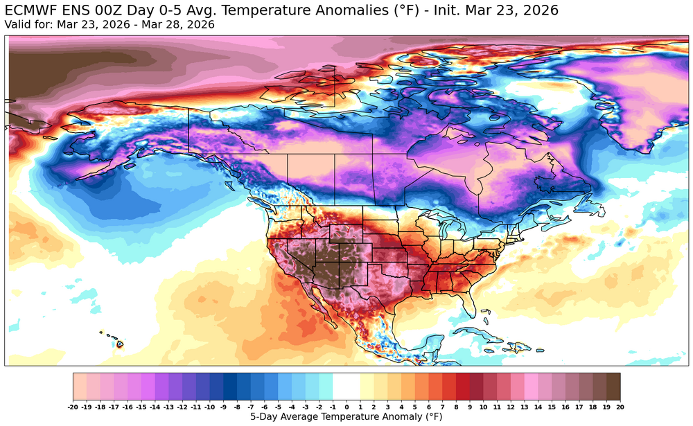
2 hours ago, SACRUS said:
SST Anomaly


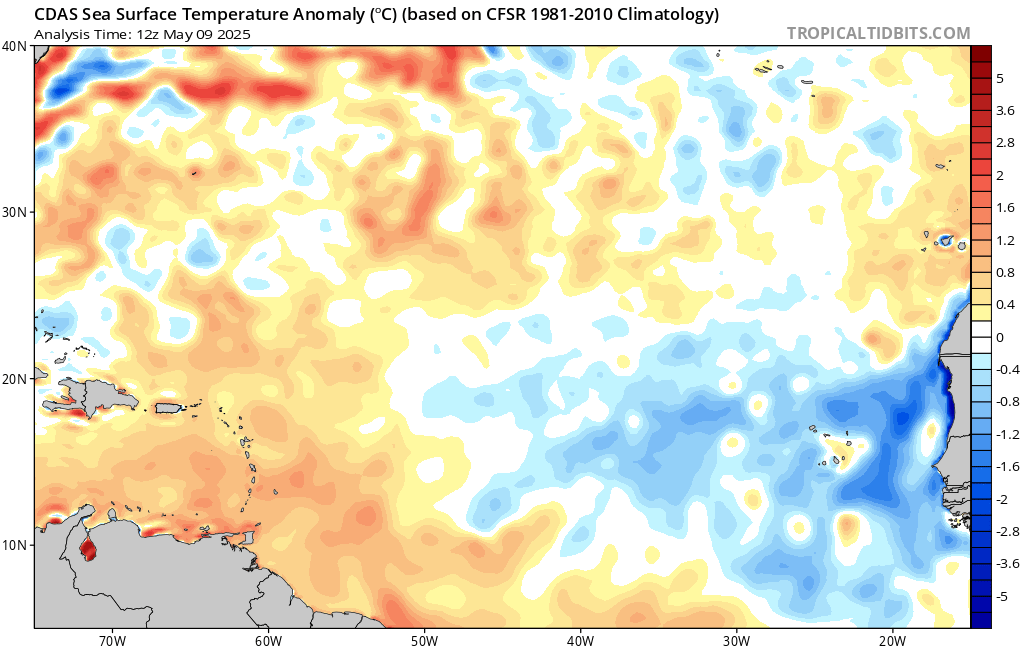
So is the cold pool off our coast a result of this past seasonably cold winter, of more of a stronger Labrador current? Or perhaps upwelling?
-
2 minutes ago, Snowlover11 said:
Wife said we had some thunder this morning? Slept right thru it. Beautiful outside now 78.

My dog ran in the closet. Thought she was crazy...
-
15 minutes ago, steve392 said:
So is it now the norm to just have non-stop windy days?? Yea it's gorgeous but this wind is just annoying.
It has been windy the last 5-7 years.
-
 1
1
-
-
2 hours ago, SACRUS said:
Records:
Highs:
EWR: 91 (1960)
NYC: 91 (1915)
LGA: 88 (2009)
JFK: 88 (1960)
Lows:
EWR: 34 (1936)
NYC: 29 (1919)
LGA: 36 (1971)
JFK: 34 (2001)
Historical:
1874: 15 inches of late-season snow fell in Newton, NJ. (Ref. Wilson Wx. History)1875 - New York City received three inches of snow, the latest measurable snow of record for that location. (David Ludlum)
1880: A violent tornado, at times up to 400 yards wide, swept away at least 20 homes in Macon, MS. Pieces of some of the homes were found 15 miles away. 22 people died and 72 were injured. Loaded freight cars were thrown 100 yards into homes. A cloth was carried for eight miles. (Ref. Wilson Wx. History)1898 - The temperature at Volcano Springs CA hit 118 degrees to establish a U.S. record for the month of April. (The Weather Channel)
1910 - Chicago, IL, was blanketed with 2.5 inches of snow, and a total of 6.5 inches between the 22nd and the 26th. It was the latest significant snow of record for the city. (The Weather Channel)
1912: Ponca City, OK was struck by an F4 tornado. One person was killed and 119 homes were damaged or destroyed. Dozens of oil derricks were flattened or twisted, southwest of town. The tornado was reportedly visible and audible for 20 miles. (Ref. Wilson Wx. History)1920 - Atlanta, GA, received 1.5 inches of snow, and experienced their latest freeze of record with a morning low of 32 degrees. The high of just 39 degrees was only their second daily high colder than 40 degrees in April. (The Weather Channel)
1925: The maximum temperature for the date is 96°F. at the Richmond International Airport and the highest for the month and also occurred on four other dates. (Ref. Richmond Weather Records - KRIC)1984 - A late season snowstorm struck the Northern Rockies and the Northern Plains. The storm produced some unsually high snowfall totals. The town of Lead, located in the Black Hills of western South Dakota, was buried under 67 inches of snow. Red Lodge, located in the mountains of southern Montana, reported 72 inches of snow. Up to 60 inches blanketed the mountains of northern Wyoming. It was rated the worst late season storm of record for much of the affected area. (25th-28th) (Storm Data) (The Weather Channel)
1986: Chicago, IL recorded high temperatures of 90 °F on this date and the 26th. Besides setting back-to-back records on both dates, this was the second April in history to record temperatures of at least 90 °F on two days. The previous year was 1952. Quincy, IL set the high temperature record for April when the high reached 92°. Springfield, IL tied their April record with 90°. (Ref. Wilson Wx. History)
1987 - Low pressure off the coast of North Carolina produced heavy rain flooding creeks in the foothills and the piedmont area, before moving out to sea. The low pressure system also produced wind gusts to 50 mph in Virginia. (The National Weather Summary) (Storm Data)
1988 - Thunderstorms racing at 65 mph produced large hail in Alabama and Georgia. Hail damage in Alabama was estimated at fifty million dollars, making it their worst weather disaster since Hurricane Frederick in 1979. Hail three inches in diameter accompanied a tornado near Valdosta GA. Hail four and a half inches in diameter was reported south of Atlanta GA. (The National Weather Summary) (Storm Data)
1989 - Thunderstorms developing along a stationary front produced severe weather from North Carolina to Indiana and Ohio, with more than 70 reports of large hail and damaging winds. A strong (F-2) tornado hit Xenia OH injuring 16 persons and causing more than a million dollars damage. (The National Weather Summary) (Storm Data)
1990 - Thunderstorms produced severe weather from Texas to Nebraska. Thunderstorms spawned fifteen tornadoes, including a powerful (F-4) tornado near Weatherford TX. Between 3 PM and 8 PM, a storm complex tracking northeastward across central Kansas spawned four tornadoes along a 119-mile path from Ness to Smith Center, with the last tornado on the ground for 55 miles. Del Rio TX was raked with hail two inches in diameter, and wind gusts to 112 mph. Brown County and Commanche County in Texas were deluged with up to 18 inches of rain, and flooding caused more than 65 million dollars damage. Two dozen cities in the north central U.S. reported record high temperatures for the date. Highs of 87 degrees at Flint MI and 90 degrees at Alpena MI were records for April. (Storm Data) (The National Weather Summary)
1994: Strong winds of 60 to 70 mph created dust storms that reduced visibilities to near zero over parts of southwest Kansas. A dust storm warning was issued which is extremely uncommon. Zero visibility in areas forced vehicles off roadways. A Kansas Highway Patrol spokesman was quoted as saying “it was parallel to whiteout in a snowstorm”. A tornado was reported in Dallas County, Texas killing three people and injuring 27. Damage totaled $200 million dollars. Further north, record rainfall occurred in parts of eastern Minnesota and western Wisconsin. The following locations had their wettest April day on record: Sparta, WI: 3.80", Hokah, MN: 3.55", La Crescent, MN: 3.43", Cashton, WI: 3.22", Ontario, WI: 3.00 inches. (Ref. Wilson Wx. History)
1996: International Falls, MN recorded 9.6 inches of snow in a late season snowstorm. This brought the city's seasonal snowfall to 116.0 inches. This broke the old seasonal snowfall record of 111.0 inches set in 1992-93. (Ref. Wilson Wx. History)
1997: Amarillo, TX recorded 6.5 inches of snow for its greatest April snowstorm on record. (Ref. Wilson Wx. History)2008 - Anchorage, AK, receives a record 17.2 inches at the airport and 22 inches in northeast Anchorage from the 25th to 26th. The 15.5 inches on the 25th makes it the third most received on any one day in Anchorage.
Gotta love 1874...
-
15 hours ago, psv88 said:
Barely any rain today. Cold. Awful
A light intermittent spritz between 1 PM and 4 pm is not going to cut it...
-
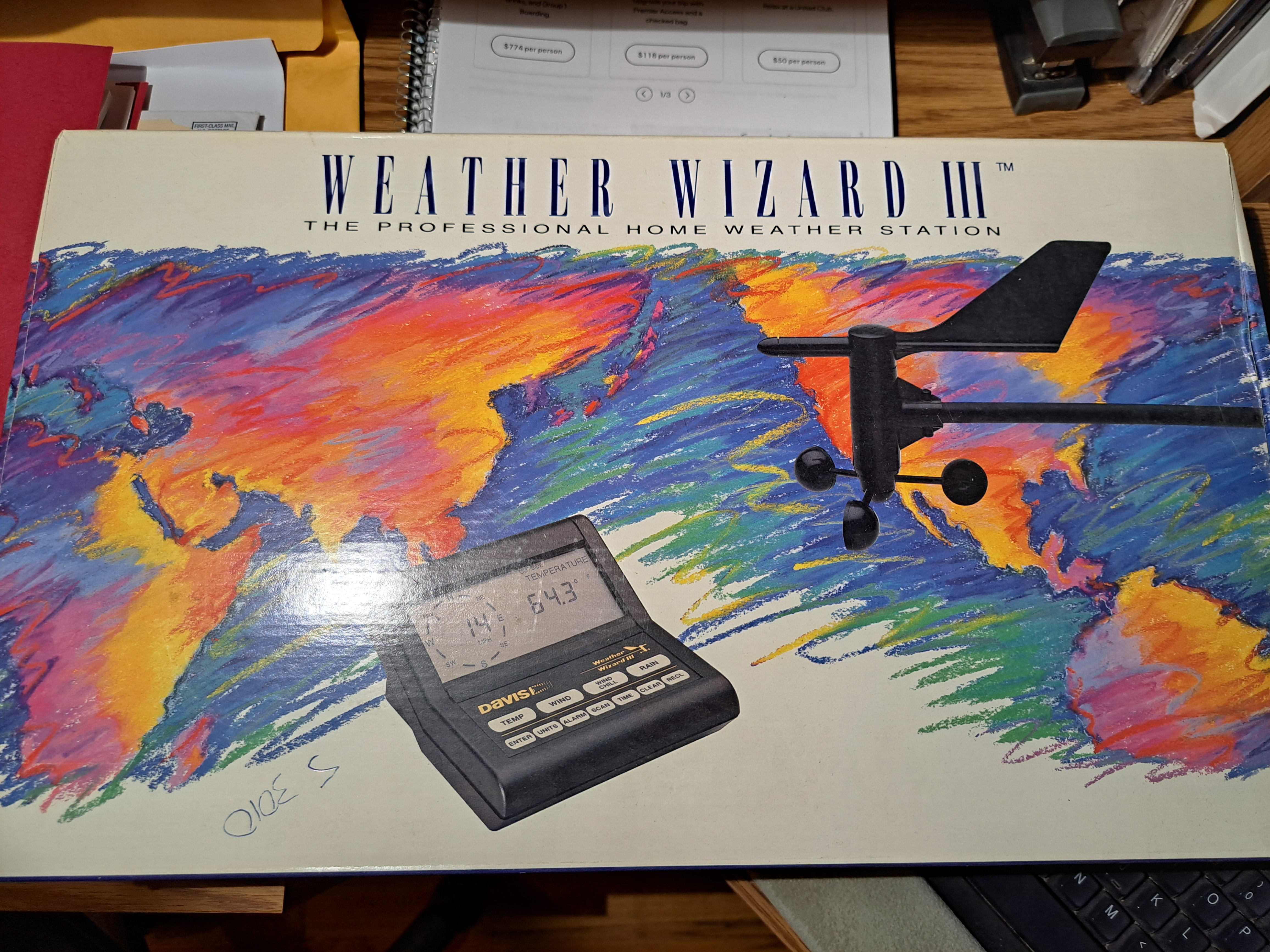
FREE Weather Wizard III. I dont know if this is allowable within the regulations of this site. If not, many pardons. I wish to give away an unused Weather Wizard III as my moving away gift to anyone on the forum. Older technology, so maybe it can just be used for parts? I prefer not to ship. I live in Garwood NJ 07027. Never Used!!!

-
7 hours ago, FPizz said:
25 last night. Looking forward to more sustained warm temps.
Beautiful sitting on my back deck from 1130AM on, once the breeze died down...
-
1
-
-
2 hours ago, MJO812 said:
Beautiful forecast for International Falls , Minnesota.
They really need locusts...
-
 1
1
-
-
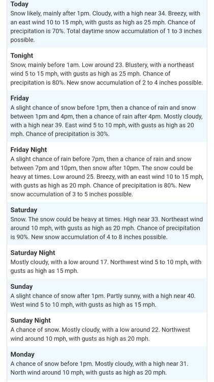
3 hours ago, NEG NAO said:
From this mornings 20's to some 80's 3 days later NWS Wednesday temps:

Of course they were calling for snow last week...
-
1
-
-
1 hour ago, snowman19 said:
Once again, JB’s bombastic prediction of a huge return to deep winter, “delayed spring”, arctic cold and snowstorms in the east, from 3/15 through Easter Sunday looks to be a monumental, epic fail. I’m sure he will never acknowledge it and simply move on like it never even happened just like he does every year…..
Too many people have figured out that life's events happen too frequently for people to remember erroneous bad predictions or bombastic lies...
-
2
-
 2
2
-
-
49 minutes ago, psv88 said:
Maybe it’s historic, maybe it’s not. How do we know what the weather was 300 years ago?
Science uses tree rings, ice core samples, sedimentary rock, etc. to determine temperatures from past years...
-
3 minutes ago, WeatherGeek2025 said:
WINTER IS OVER!

-
1 hour ago, bluewave said:
Looks like the warm front will come north again this Thursday for the next 70° potential at the usual spots. Would be nice if the warm sector can push further north than yesterday. Had the marine layer all day yesterday here on the CT Shoreline while NJ mad it to 70°+.
Then another a cooldown for a few days as Canada and the Northeast briefly gets colder.
It’s possible that some of the local warm spots could make a run on 75°-80° during the first week of April as the Southeast ridge flexes and trough tries to dig into the West.
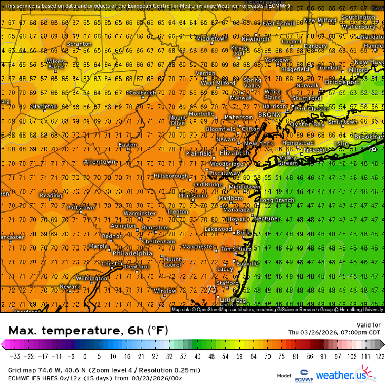
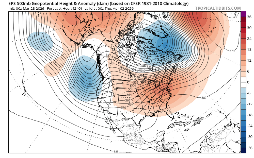
It's over...
-
3
-
-
2 hours ago, psv88 said:
Nah, temps will bust low. Don’t think most of us crack 50 east of the city
Cloudy, windy and cool along Barnegat Bay, NJ this morning...
-
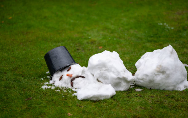
15 hours ago, SACRUS said:
Flurries pooping up
woke up to some powdered sugar on some surfaces this morning...
-
1
-
-
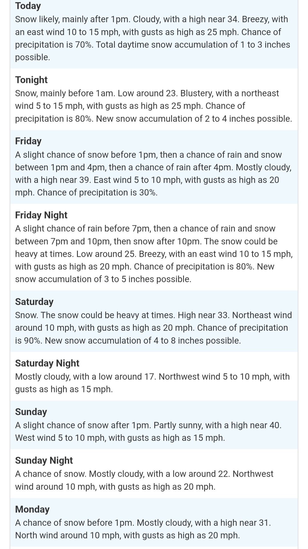
2 hours ago, MJO812 said:
My dream
With
Hard to believe this is illustrating a recent storm. High totals were between 30" and 40". With the snow, consistently up to the shoulders (consistently), this would mean a five foot depth?
-
On 3/13/2026 at 8:05 AM, Brian5671 said:
yep too many people speaking in absolutes...this winter proved them wrong
I didn't expect a real winter, not with that Pacific jet out there...
-
-
3 minutes ago, MJO812 said:
35 right now
Beautiful morning
It would be, if it weren't so windy...
-
Snow stopped, getting brighter...
-
Flurrying in Garwood NJ (Central Union county)
-
1
-


Spring 2026 Pattern Discussion Thread
in Tennessee Valley
Posted
Meteorologist by education. I worked two summers at a now defunct weather forecasting office and one year in an engineering firm. My claim to fame was filling in at CBS NYC for 2 weeks. I told Steve Deshler that it looks like an Easter snow storm, perhpas about a foot of the white stuff. Irv Gikofsky, aka Mr. G., commented that it was impossible. Sure enough, we got about 14" of snow.