
MANDA
-
Posts
1,294 -
Joined
-
Last visited
Content Type
Profiles
Blogs
Forums
American Weather
Media Demo
Store
Gallery
Posts posted by MANDA
-
-
Deluge here with some loud booms of thunder. Briefly gusty winds, nothing noteworthy. Rain was torrential though. Have to go officially measure but looks like 1.25" in the gauge and most of that fell in about 15 min. Keeps things green and watered. I'm good on rainfall for another week.
-
 4
4
-
-
1 hour ago, uofmiami said:
Time to move to Canada!
Only due to persistent onshore flow did we miss out on a significantly warmer than normal May. It was pretty much all around us with the exception of New England, SENY and NJ. More of the over the top warmth we have seen so much of in recent years. Even so it looks like we will finish May at 1-2 degrees above normal against the warmest 30 year normals on record.
-
35 minutes ago, SACRUS said:
Daylight 14H: 37M equivalent to July 22nd. Another 31 days of lengthening days.
Yes, another 31 days but the gain of daylight is subtle each day now. Only 15 minutes more of evening daylight gain before we reach latest sunset. We've almost dug out the hole and it will be time to start filling it back in again...so to speak.
-
1 minute ago, Rtd208 said:
The weather overall this upcoming week looks pretty good with exception of Thursday and maybe Wednesday afternoon in NW areas. Temps should range from the mid 70's to the upper 80's throughout the week. Tuesday, Wednesday and Thursday look the warmest.
I agree. We are pulling slowly out of the blocked up pattern of light rain, mist, drizzle, clouds and cool temperatures. Weather this coming week will be exponentially better than last week.
-
1
-
-
Some nasty heat in FL last few days. Interesting HI stat from Miami.
All very recent perhaps reflecting the increased moisture in the atmosphere of late.
Don't know now anyone could tolerate FL in the Summer. Just not for me. High sun angle, high temperatures and stifling humidity


-
The mist and drizzle is just unrelenting! Just drove home from the lower Hudson Valley and was a nasty drive with mist and drizzle most of the way. Just annoying at this point.
-
2
-
-
1 hour ago, donsutherland1 said:
A system will bring showers and periods of rain tomorrow into Thursday. A general 0.25"-0.75" rainfall appears likely. Additional showers are possible during the weekend.
Afterward, much of the week will likely see temperatures in the upper 60s and lower 70s. No significant early-season heat is likely through at least the first three weeks of May.
The ENSO Region 1+2 anomaly was -0.4°C and the Region 3.4 anomaly was +0.3°C for the week centered around May 8. For the past six weeks, the ENSO Region 1+2 anomaly has averaged -0.08°C and the ENSO Region 3.4 anomaly has averaged +0.73°C. Neutral conditions are now developing.
The SOI was +6.30 on May 13.
The preliminary Arctic Oscillation (AO) was +1.595 today.
Based on sensitivity analysis applied to the latest guidance, there is an implied 53% probability that New York City will have a warmer than normal May (1991-2020 normal). May will likely finish with a mean temperature near 63.5° (0.3° above normal).
Don-
This is first time in recent memory that the temperature sensitivity analysis has been lowering as the month is progressing. Usually it rises as we work through the month. Interesting to see if we finish the month slightly below normal. My guess is not from NYC on west. Time will tell.
-
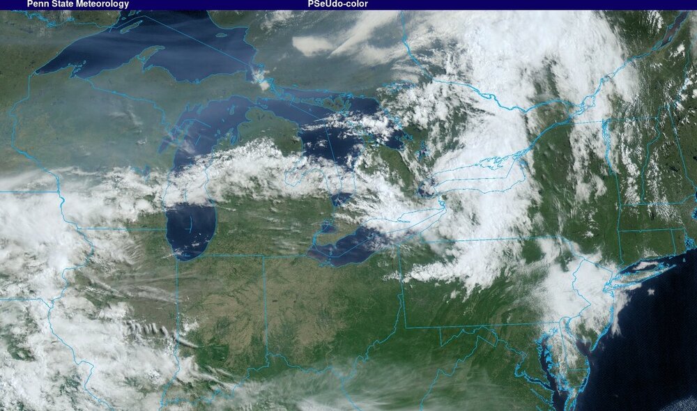
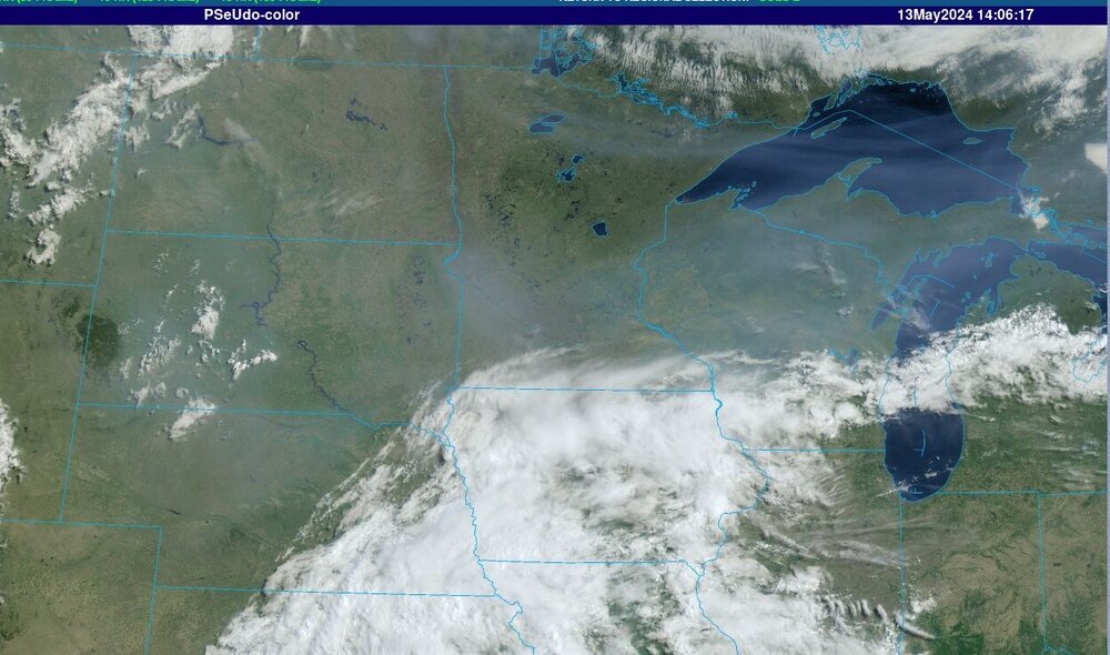
Canadian forest fires are underway. Smoke affecting the Northern Plains into the Great Lakes. Air quality alerts are posted over parts of MN and WI.
-
Two day event total was .58". Daytime temperatures yesterday never got out of the m/u 40's. Everything nice and green and rain is keeping the pollen at bay so there is that.
-
3
-
-
Currently 47 and .37" rainfall so far.
-
1
-
-
12 minutes ago, Stormlover74 said:
Clouds rolled in quickly
Nam for tomorrow morning
.thumb.png.a9d2abd17ff3e42bfe4d03ed0b77d6d2.png)
Putting down some fertilizer today!
-
1
-
-
2 minutes ago, Picard said:
Balmy early May evening. I'm still at 73. Feels like summer.
I'm not looking forward to the return to raw and cold. It's the month when both the AC and heat will run, sometimes within 48 hours of one another.Been a lot of back and forth lately with AC vs. heat (heat especially in the mornings)
It is warm out tonight. Still 70 here.
-
1
-
-
A quick .18" in a fast moving but heavy downpour.
-
28 minutes ago, donsutherland1 said:
The mean temperature in New York City during the first week of May was 61.6°. That was 1.6° above normal.
After a morning shower or thundershower, tomorrow will be another unseasonably warm day with readings reaching the upper 70s and lower 80s across the region. The highest readings are likely in and around Philadelphia where the temperature could top out in the middle or even upper 80s. Another shot of cooler air will likely arrive on Thursday. The chill won't be exceptional for the season.
The ENSO Region 1+2 anomaly was 0.8°C and the Region 3.4 anomaly was +0.5°C for the week centered around May 1. For the past six weeks, the ENSO Region 1+2 anomaly has averaged -0.08°C and the ENSO Region 3.4 anomaly has averaged +0.85°C. The ongoing basinwide El Niño event is fading. Neutral conditions could develop later in the spring.
The SOI was +7.14 today.
The preliminary Arctic Oscillation (AO) was +0.200 today.
Based on sensitivity analysis applied to the latest guidance, there is an implied 60% probability that New York City will have a warmer than normal May (1991-2020 normal). May will likely finish with a mean temperature near 64.3° (1.1° above normal).
One above normal month (May projected) after another against the highest set of 30 year "normals" we have. You would have to be a high roller to bet against an above normal Summer at this point. Might not be outrageous heat but 2-3 above normal for JJA would not surprise me in the least. Mainly from slightly above normal highs and very warm overnight lows. We'll see.
-
1
-
-
Horrible drone footage coming out of Oklahoma this morning. Especially Barnsdall, OK. Looks like solid EF3 damage and maybe EF4.
Concrete slabs left where houses used to be. Steel beams twisted like plastic straws.
-
 1
1
-
-
Radar exploding over western Oklahoma. Going to be a dangerous and scary night for people out there. Good amount of rotation going on already.
-
1
-
-
3 minutes ago, SACRUS said:
Daylight H:14:M:10 Roughly equivalent to Aug 5th.
Just about 30 minutes to go until latest sunset.
Marching forward!
-
1
-
-
Two day event total rainfall = .62".
-
Jersey be cooking sans the barrier beaches.

-
2
-
-
54 minutes ago, Stormlover74 said:
Hard to believe mid 80s today based on what it looks like now
Per visible satellite loop low clouds eroding west to east pretty quickly. Should warm up nicely once the sun breaks out.
-
1
-
1
-
-
Just now, SACRUS said:
Up to 81 today here in CNJ pollen is quite high.
The pollen dust in terrible. Just nasty.
-
1
-
-
Received .25" rainfall in the T-Shower last night.
-
 Great CTG Lighting and booms of thunder. Rocking and rolling.
-
1
-
-
Vivid lightning show to my south and southwest: Nice rumbles of thunder and it is raining now.


.png.ec57da24aff30c59b66c6d11e36ed29e.png)

May 2024
in New York City Metro
Posted
Not a bad looking Drought Monitor as we head into the Summer.