VivaManchVegas
-
Posts
160 -
Joined
-
Last visited
Content Type
Profiles
Blogs
Forums
American Weather
Media Demo
Store
Gallery
Everything posted by VivaManchVegas
-

“Cory’s in NYC! Let’s HECS!” Feb. 22-24 Disco
VivaManchVegas replied to TheSnowman's topic in New England
It was a different time. -
“Cory’s in NYC! Let’s HECS!” Feb. 22-24 Disco
VivaManchVegas replied to TheSnowman's topic in New England
We live in different times. We all have enough information in the palm of our hand, sometimes too much. We lived in SNH at the time and my dad was smart enough to get out of Boston early as he was a Local 103 member. I should revisit that with him and why he got out on time. But anyway, it is interesting to note I think SNH did not get that much snow but the drifts were crazy. Our neighbor had a drive in basement garage that was completely covered over by snow. It appears the wind will be wild with this one. -
“Cory’s in NYC! Let’s HECS!” Feb. 22-24 Disco
VivaManchVegas replied to TheSnowman's topic in New England
Well I had to pull Lucy holding the football. This one came to mind. -
“Cory’s in NYC! Let’s HECS!” Feb. 22-24 Disco
VivaManchVegas replied to TheSnowman's topic in New England
Probably one of the last black and whites that still holds up. -
“Cory’s in NYC! Let’s HECS!” Feb. 22-24 Disco
VivaManchVegas replied to TheSnowman's topic in New England
Don't you effing start with this. I am happy with an 8" pile while I watch everyone else south of me get burried. -
“Cory’s in NYC! Let’s HECS!” Feb. 22-24 Disco
VivaManchVegas replied to TheSnowman's topic in New England
Peter sellers with a great Dr. Strangelove. -
“Cory’s in NYC! Let’s HECS!” Feb. 22-24 Disco
VivaManchVegas replied to TheSnowman's topic in New England
The wind is going to be wild. Its been awhile since we had this much heavy wet snow with the wind. Good luck Boston and south east. Holy molly. -
Is we back? February discussion thread
VivaManchVegas replied to mahk_webstah's topic in New England
Kearsarge? -
Is we back? February discussion thread
VivaManchVegas replied to mahk_webstah's topic in New England
The cold is effing relentless. I though next week was going warm... the Euro says niet. -
“Cory’s in NYC! Let’s HECS!” Feb. 22-24 Disco
VivaManchVegas replied to TheSnowman's topic in New England
Unbelievable... so steady for so long now this.. laughable. -
“Cory’s in NYC! Let’s HECS!” Feb. 22-24 Disco
VivaManchVegas replied to TheSnowman's topic in New England
The poor evergreens. Don't have a chance -
“Cory’s in NYC! Let’s HECS!” Feb. 22-24 Disco
VivaManchVegas replied to TheSnowman's topic in New England
-
“Cory’s in NYC! Let’s HECS!” Feb. 22-24 Disco
VivaManchVegas replied to TheSnowman's topic in New England
-
“Cory’s in NYC! Let’s HECS!” Feb. 22-24 Disco
VivaManchVegas replied to TheSnowman's topic in New England
This is going to be a paste bomb for sema and the cape. Everyone get the generators ready tomorrow. -
“Cory’s in NYC! Let’s HECS!” Feb. 22-24 Disco
VivaManchVegas replied to TheSnowman's topic in New England
I thought we would skate with 6" on this one. Not feeling that way now. I just got done shoveling my roof. This blows. Happy for all you guys in the bulls eye. Its going to be wild with the wind. -
“Cory’s in NYC! Let’s HECS!” Feb. 22-24 Disco
VivaManchVegas replied to TheSnowman's topic in New England
You people in Weymouth better tie everyone down.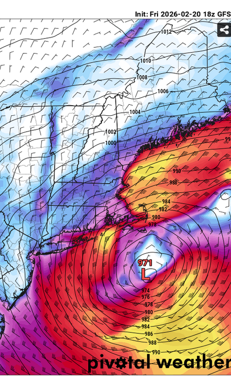
-
“Cory’s in NYC! Let’s HECS!” Feb. 22-24 Disco
VivaManchVegas replied to TheSnowman's topic in New England
You can effing have it. GFS has been on this for a while. Glad for everyone down south. -
“Cory’s in NYC! Let’s HECS!” Feb. 22-24 Disco
VivaManchVegas replied to TheSnowman's topic in New England
Understood. I have been watching storm for so long... you loose sight it is still 4 days away. -
“Cory’s in NYC! Let’s HECS!” Feb. 22-24 Disco
VivaManchVegas replied to TheSnowman's topic in New England
That is fair. I posted earlier about Gray mentioning that the main event just now getting sampled over the main land so I am not surprised. Full disclosure, I would love zero snow from the Monday storm. I can take the 6 inches from Fri nights storm. -
“Cory’s in NYC! Let’s HECS!” Feb. 22-24 Disco
VivaManchVegas replied to TheSnowman's topic in New England
What am I missing here with the latest Euro? Still at best a SENE storm? 6 inches for boston, 8 to 12 for the cape? Everyone riding the trend? -
“Cory’s in NYC! Let’s HECS!” Feb. 22-24 Disco
VivaManchVegas replied to TheSnowman's topic in New England
Maybe it will minimize any flooding risks. -
“Cory’s in NYC! Let’s HECS!” Feb. 22-24 Disco
VivaManchVegas replied to TheSnowman's topic in New England
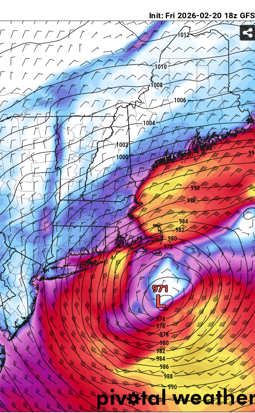
This was in this mornings write up from Gray. There is still hope for some of you massacists. A trough begins digging into the Mid-Atlantic Sunday sparking cyclogenesis off the coast of the Carolinas. Meanwhile, high pressure builds over the northeast making for a mostly dry day with seasonable high temperatures. The aforementioned low begins moving northeast up the coast with many ensemble solutions suggesting high pressure keeps it mostly at sea. However, there are some notable recent trends in the ensemble guidance. The wave of interest that ultimately kick starts this is just coming into range of the RAOB network and really doesn`t enter the Pacific Northwest until later today. That being said with what limited recon data the models have been able to incorporate, they have trended the ridge in the western CONUS more westerly. This would ultimately allow the low to end up closer to the coast and result in a greater chance for a more impactful snowfall for the Northeast. While the majority of ensemble members are clustered well to the south and east of the benchmark, there are still more than a few members nearby. It would be unwise to write this one off just yet until it can be sampled further. -
“Cory’s in NYC! Let’s HECS!” Feb. 22-24 Disco
VivaManchVegas replied to TheSnowman's topic in New England
Damn.. he had my hopes up. -
Is we back? February discussion thread
VivaManchVegas replied to mahk_webstah's topic in New England
There will be some really nice days between now and then.. hang on. I feel your pain. -
Is we back? February discussion thread
VivaManchVegas replied to mahk_webstah's topic in New England
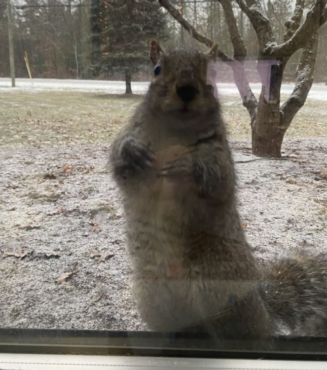
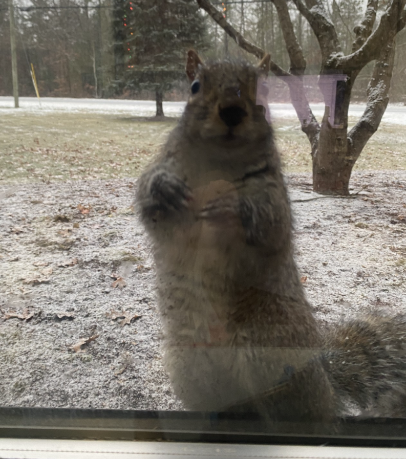
Just took a walk around the yard to throw some raw peanuts at the squirrels. Its been a rough year for them. I had no acorns in my yard this year and I have 50 year old monster oak in my front yard. Feed them at work as well. Below is fat Eddie just after our mini melt in January. He bangs on my glass now and then. It was actually pretty nice out. 12 to 14 inches of snow pack still and we topped out at 39.