

TalcottWx
-
Posts
28,808 -
Joined
Content Type
Profiles
Blogs
Forums
American Weather
Media Demo
Store
Gallery
Everything posted by TalcottWx
-
They increased these numbers again.
-
Hopefully we can cloud the sun and make it suffocating later this evening for you.
-
https://gispub.epa.gov/airnow/?contours=ozonepm&monitors=pm25&xmin=-9623192.404576134&xmax=-7275046.895656143&ymin=4586019.5282946825&ymax=5607218.226184366
-
This is nothing short of insane.
-
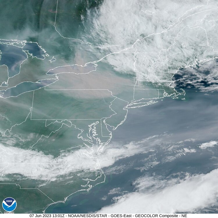
The visible satellite suggests AQI well above 200 is on the way to NYC metro.
-
DEEP just upped the forecast for AQI today. Around 150 state wide. It is already at those levels now.
-
Their forecasts have been so terribly low compared to verification, also.
-
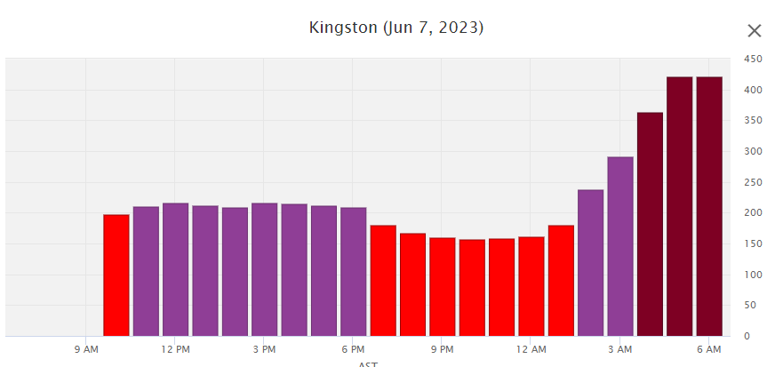
The forecast is a bit more unknown today I think, but the smoke quality is very poor across Western CT, all sites over 150 AQI. Smoke does increase after a slight improvement in the AM hours. But this seems to be mainly a S and W CT day for the highest AQI. Mid-Atlantic should be smokier than us today I believe, but tough this is these fires spread faster than models can track them. Kingston Ontario is so much worse than us, incredible numbers up to our north.
-
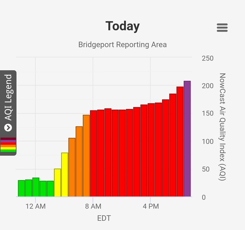
Such a rare event today to nerd out over. Look at this hourly chart at Bridgeport. Conditions were already super impressive and they continue to deteriorate. You have to wonder if tomorrow is worse than today, considering we were only forecast at 125~ AQI max today.
-
208 at Bridgeport, Stratford, and Westport. That's a new level of bad. Yes I enjoy talking to myself about air quality. 218 (!) in Queens.
-
198 at three sites: Stratford, Westport, Bridgeport. Pm10 has been rocketing since this afternoon, and continues to increase. PM2.5 seems to be plauteauing. Some information you might find educational, as I had no idea of any of this before today: "PM2.5 is more likely to travel into and deposit on the surface of the deeper parts of the lung, while PM10 is more likely to deposit on the surfaces of the larger airways of the upper region of the lung. Particles deposited on the lung surface can induce tissue damage, and lung inflammation." CA.gov goes on to detail," Emissions from combustion of gasoline, oil, diesel fuel or wood produce much of the PM2.5 pollution found in outdoor air, as well as a significant proportion of PM10. PM10 also includes dust from construction sites, landfills and agriculture, wildfires and brush/waste burning, industrial sources, wind-blown dust from open lands, pollen and fragments of bacteria." The EPA states," Of these, particles less than 2.5 micrometers in diameter, also known as fine particles or PM2.5, pose the greatest risk to health." According to one study, there's a link between PM2.5 from wildfires and increased risk of hospitalizations for cardiopulmonary diseases. There's a ton of different things to consider when it comes to this stuff, that's for sure. Interesting to read up on.
-
193 now in Torrington, making a run at 200.
-
Lightning just really increased. Mid-level magic.
-
Wind increasing and some new cells popping along the line as it enters nw CT.
-
AQI now 188 Torrington. At 200, air is considered 'very unhealthy' for entire population.
-
Line coming toward nw CT was just warned, and it's intensifying.
-
Winds kicked up and we're gusty for a few hours. Dead still now. Storms rolling around from the NW.
-
Waterbury AQI 182 PM2.5, and 133.6 µg/m3.
-
I miss the traffic and congestion oh so much. Naht
-
Storms just don't happen where I live, no matter where I live
-
Incredible. Hartford is up to 171 AQI.
-
Storms seem to be ramping back up after a period of reorganization.
-
This stuff has a good trajectory for my hood.
-
That's an impressive set of storms near Albany.
-
I've seen much more pathetic threats be severe watched.


