WeatherGeek2025
-
Posts
1,616 -
Joined
-
Last visited
Content Type
Profiles
Blogs
Forums
American Weather
Media Demo
Store
Gallery
Everything posted by WeatherGeek2025
-

Extreme Cold, Snow & Sleet: SECS 1/24 - 1/26
WeatherGeek2025 replied to TriPol's topic in New York City Metro
-
Extreme Cold, Snow & Sleet: SECS 1/24 - 1/26
WeatherGeek2025 replied to TriPol's topic in New York City Metro
HRRR 12z compared to globals -
Winter cancelled/uncancelled banter 25/26
WeatherGeek2025 replied to Rjay's topic in New York City Metro
New York Forecast by Feen : Tonight: Cold breezy with a low of 25, Friday sunny and cold high of 31. Friday Night Coldest night of the year 7 degrees. Saturday: Becoming cloudy by late afternoon cold with a high of 18. Saturday Night Cold with a low of 15 with snow by 7am. Sunday: Heavy snow 8-12 inches of snow. High 23. Sunday Night: Snow and some sleet low 26; 2-4 inches of slop. -
Extreme Cold, Snow & Sleet: SECS 1/24 - 1/26
WeatherGeek2025 replied to TriPol's topic in New York City Metro
we don't know what's going to happen, this could easily trend south or stay where it's at we don't know! -
Extreme Cold, Snow & Sleet: SECS 1/24 - 1/26
WeatherGeek2025 replied to TriPol's topic in New York City Metro
i guess we can't get rid of that warm nose so we sleet okay we're getting to consensus here i guess! Sucks i really wanted an all done event -
Extreme Cold, Snow & Sleet: SECS 1/24 - 1/26
WeatherGeek2025 replied to TriPol's topic in New York City Metro
Tony is it colder or warmer or the same? -
“Cory’s in LA! Let’s MECS!” Jan. 24-26 Disco
WeatherGeek2025 replied to TheSnowman's topic in New England
don't mean to clutter here but i love your screen name picture -
January 24-26: Miracle or Mirage JV/Banter Thread!
WeatherGeek2025 replied to SnowenOutThere's topic in Mid Atlantic
i'm convinced the government in new york is stupid and a scam to take our money -
Extreme Cold, Snow & Sleet: SECS 1/24 - 1/26
WeatherGeek2025 replied to TriPol's topic in New York City Metro
GFS ROLLING -
Extreme Cold, Snow & Sleet: SECS 1/24 - 1/26
WeatherGeek2025 replied to TriPol's topic in New York City Metro
the only thing that i'll be looking for tonight is see if the GFS changes, and i'm hoping the best model Euro AI goes a bit south from earlier runs! I'll go to sleep happy! -
Extreme Cold, Snow & Sleet: SECS 1/24 - 1/26
WeatherGeek2025 replied to TriPol's topic in New York City Metro
cause it's counting the sleet as snow -
Extreme Cold, Snow & Sleet: SECS 1/24 - 1/26
WeatherGeek2025 replied to TriPol's topic in New York City Metro
i'd go with hrrr once in range. Nam sucks -
Extreme Cold, Snow & Sleet: SECS 1/24 - 1/26
WeatherGeek2025 replied to TriPol's topic in New York City Metro
-
“Cory’s in LA! Let’s MECS!” Jan. 24-26 Disco
WeatherGeek2025 replied to TheSnowman's topic in New England
-
Extreme Cold, Snow & Sleet: SECS 1/24 - 1/26
WeatherGeek2025 replied to TriPol's topic in New York City Metro
-
-
Extreme Cold, Snow & Sleet: SECS 1/24 - 1/26
WeatherGeek2025 replied to TriPol's topic in New York City Metro
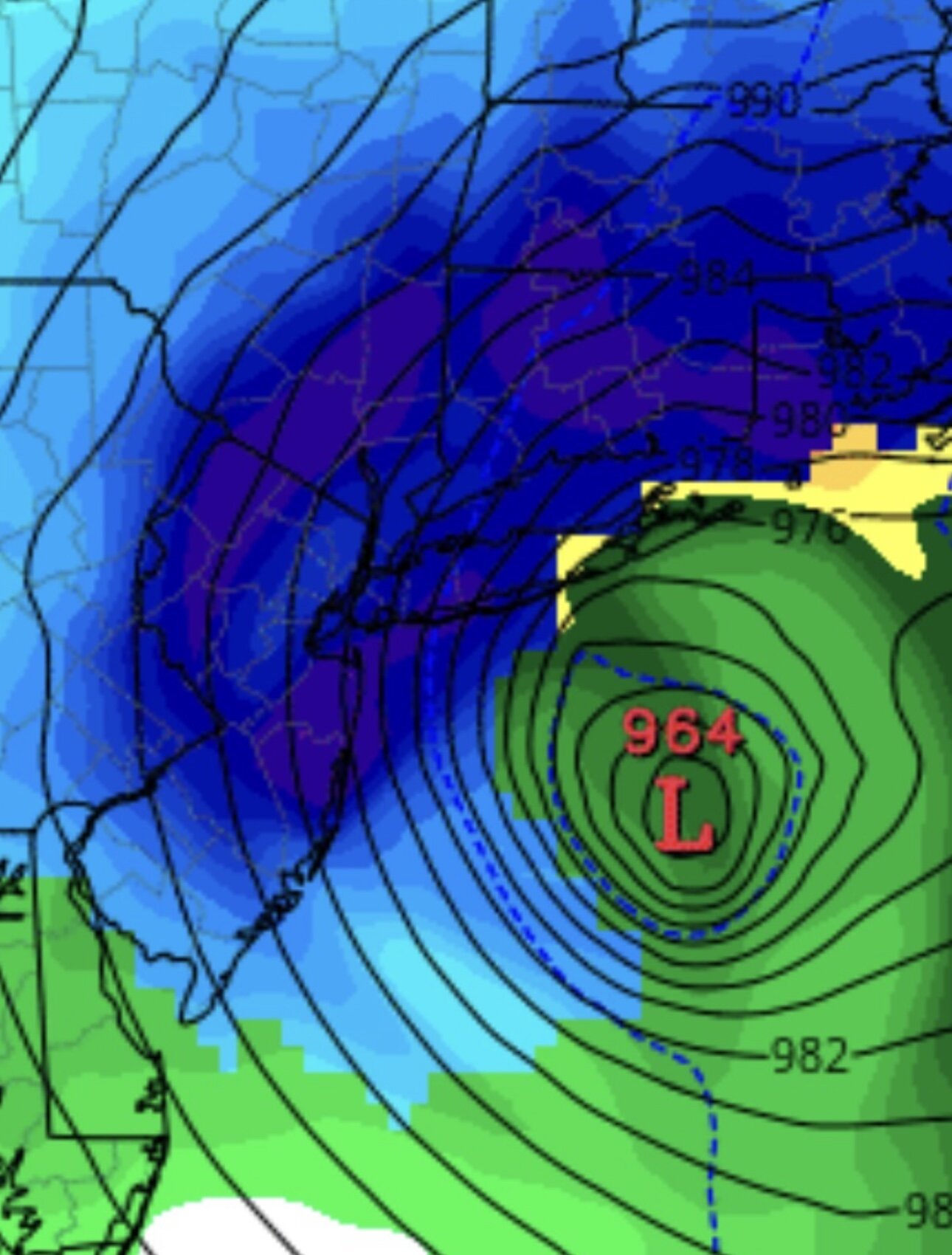
hrrr -
Extreme Cold, Snow & Sleet: SECS 1/24 - 1/26
WeatherGeek2025 replied to TriPol's topic in New York City Metro
what's with the 6's? every decade big storm -
Extreme Cold, Snow & Sleet: SECS 1/24 - 1/26
WeatherGeek2025 replied to TriPol's topic in New York City Metro
snowman19 -
Extreme Cold, Snow & Sleet: SECS 1/24 - 1/26
WeatherGeek2025 replied to TriPol's topic in New York City Metro
if the mixing happens NYC and south. According to GFS New York doesn't change over at all! -
“Cory’s in LA! Let’s MECS!” Jan. 24-26 Disco
WeatherGeek2025 replied to TheSnowman's topic in New England
where's NY? I added your area on my snowmap! -
Extreme Cold, Snow & Sleet: SECS 1/24 - 1/26
WeatherGeek2025 replied to TriPol's topic in New York City Metro
isn't this the same snowstorm that a week or so ago GFS had 70 inches for someone in northern Pennsylvania? someone could end up with 36 inches if we get a big storm like the GFS! -
Extreme Cold, Snow & Sleet: SECS 1/24 - 1/26
WeatherGeek2025 replied to TriPol's topic in New York City Metro
Euro looks like it's trending to the GFS -
ScreenRecording_01-22-2026 17-27-23_1.mov
-
Extreme Cold, Snow & Sleet: SECS 1/24 - 1/26
WeatherGeek2025 replied to TriPol's topic in New York City Metro
ScreenRecording_01-22-2026 17-27-23_1.mov


