WeatherGeek2025
-
Posts
1,682 -
Joined
-
Last visited
Content Type
Profiles
Blogs
Forums
American Weather
Media Demo
Store
Gallery
Everything posted by WeatherGeek2025
-

“Cory’s in LA! Let’s MECS!” Jan. 24-26 Disco
WeatherGeek2025 replied to TheSnowman's topic in New England
okay i'll text you here monday and see who was wrong. I can be wrong im not saying that but im not falling for a crappy model thats getting retired! Yes we will mix with some sleet but that sleet line will drop south immediately once the low pressure starts taking shape off the coast of Jersey -
“Cory’s in LA! Let’s MECS!” Jan. 24-26 Disco
WeatherGeek2025 replied to TheSnowman's topic in New England
Nam doesn't have strengths we've been through this before! Nam is literally the worst model and they're retiring it for a reason. HRRR is the model to use and rap -
“Cory’s in LA! Let’s MECS!” Jan. 24-26 Disco
WeatherGeek2025 replied to TheSnowman's topic in New England
i'm north of the city, I think NAM is on crack -
“Cory’s in LA! Let’s MECS!” Jan. 24-26 Disco
WeatherGeek2025 replied to TheSnowman's topic in New England
Nam vs Euro -
Extreme Cold, Snow & Sleet: SECS 1/24 - 1/26
WeatherGeek2025 replied to TriPol's topic in New York City Metro
not even close -
Extreme Cold, Snow & Sleet: SECS 1/24 - 1/26
WeatherGeek2025 replied to TriPol's topic in New York City Metro
i'd go with HRRR for the storm totals! Looks like a foot of snow is common around the area and yes maybe i'm being aggressive but NAM is being retired for a reason! -
Extreme Cold, Snow & Sleet: SECS 1/24 - 1/26
WeatherGeek2025 replied to TriPol's topic in New York City Metro
NAm sucks, there's not going to be sleet in mountain creek NJ, lets be real here, nam is wrong! -
Extreme Cold, Snow & Sleet: SECS 1/24 - 1/26
WeatherGeek2025 replied to TriPol's topic in New York City Metro
stole it from NE -
Extreme Cold, Snow & Sleet: SECS 1/24 - 1/26
WeatherGeek2025 replied to TriPol's topic in New York City Metro
hrrr looks good barely mixed at the end -
Extreme Cold, Snow & Sleet: SECS 1/24 - 1/26
WeatherGeek2025 replied to TriPol's topic in New York City Metro
is it better for the city? -
Extreme Cold, Snow & Sleet: SECS 1/24 - 1/26
WeatherGeek2025 replied to TriPol's topic in New York City Metro
Grab a small wrench and tap it numerous times. Like actually hit it -
Extreme Cold, Snow & Sleet: SECS 1/24 - 1/26
WeatherGeek2025 replied to TriPol's topic in New York City Metro
it was there rap 09z run looks cold!!! -
Extreme Cold, Snow & Sleet: SECS 1/24 - 1/26
WeatherGeek2025 replied to TriPol's topic in New York City Metro
where can i find this models radar composite? -
Extreme Cold, Snow & Sleet: SECS 1/24 - 1/26
WeatherGeek2025 replied to TriPol's topic in New York City Metro
hrrr is the best short term model and it looks perfect hope it's right. -
Extreme Cold, Snow & Sleet: SECS 1/24 - 1/26
WeatherGeek2025 replied to TriPol's topic in New York City Metro
gm guys i fell asleep, i see gfs was good at 0z but not 6z euro and cmc looked pretty cold at 0z -
Extreme Cold, Snow & Sleet: SECS 1/24 - 1/26
WeatherGeek2025 replied to TriPol's topic in New York City Metro
the snow cover will last with that sleet on top -
gotta be the coldest night of the year because of the wind, i'm sure next week temps wise it'll get colder but it won't be as windy
-
Extreme Cold, Snow & Sleet: SECS 1/24 - 1/26
WeatherGeek2025 replied to TriPol's topic in New York City Metro
I think tonight's probably gonna be the coldest night of the year in terms of windchill because of the wind. It's very very brutal outside. -
Extreme Cold, Snow & Sleet: SECS 1/24 - 1/26
WeatherGeek2025 replied to TriPol's topic in New York City Metro
reggie? eedit/:::brrrrrr outside -
Extreme Cold, Snow & Sleet: SECS 1/24 - 1/26
WeatherGeek2025 replied to TriPol's topic in New York City Metro
SAVE US -
Extreme Cold, Snow & Sleet: SECS 1/24 - 1/26
WeatherGeek2025 replied to TriPol's topic in New York City Metro
i also think the NAM sucks. But it is good with the warm nose. It's a good sniffer for warm levels aloft! the best short term is hrrr and global is euro ai in my opinion mid term long term probably no model! -
Extreme Cold, Snow & Sleet: SECS 1/24 - 1/26
WeatherGeek2025 replied to TriPol's topic in New York City Metro
that model FV3 sucks honestly but i hope it's right -
Extreme Cold, Snow & Sleet: SECS 1/24 - 1/26
WeatherGeek2025 replied to TriPol's topic in New York City Metro
are they only discontinuing the regular nam or also nam 3k? -
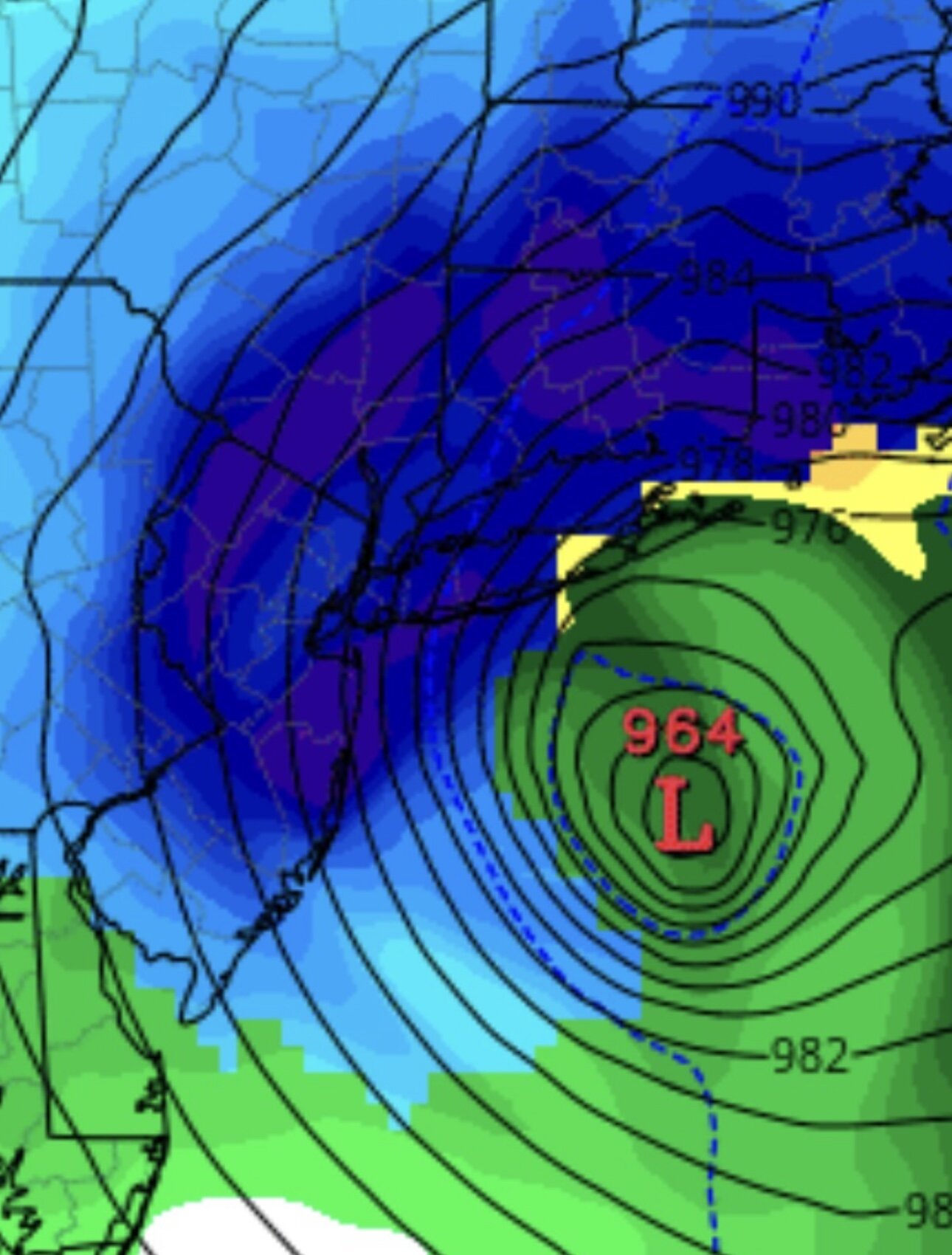
i know this will probably bust out too high, i tried and i posted this wednesday. well i can redo one tomorrow lol
-
Extreme Cold, Snow & Sleet: SECS 1/24 - 1/26
WeatherGeek2025 replied to TriPol's topic in New York City Metro
you're right the mixing went south at the warmest level, so that's a plus! reggie was pretty cold at 18z let's see what it does in 15 min


