jdt
-
Posts
846 -
Joined
-
Last visited
Content Type
Profiles
Blogs
Forums
American Weather
Media Demo
Store
Gallery
Everything posted by jdt
-
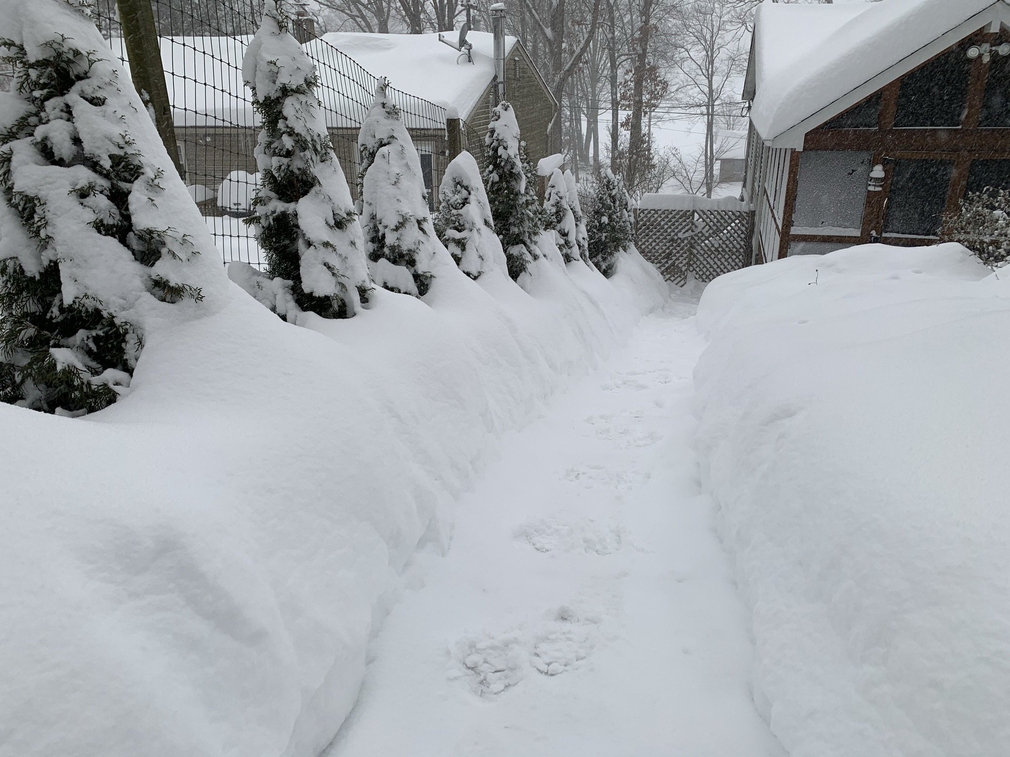
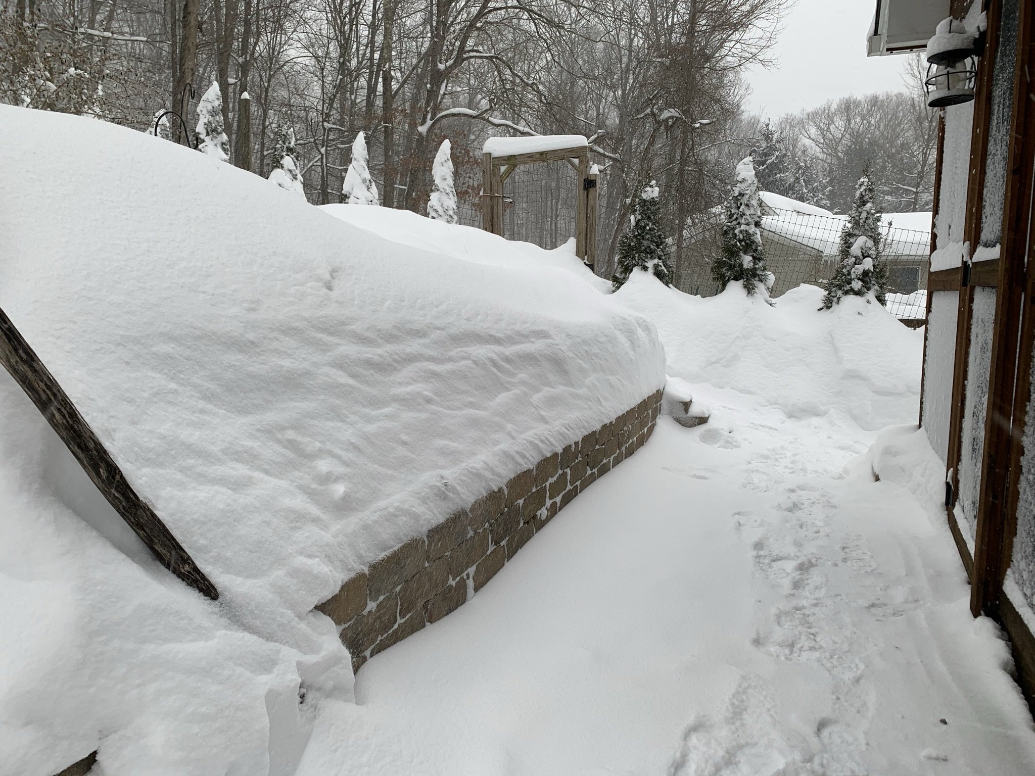
30.3” as of 9:45pm, Sparta, NW NJ w/ ~2” in last 2.5 hrs. This is my last measurement for the night. It’s possible last couple of measurements have been impacted by wind as they picked up about 3-4 hours ago but still generally under 15 with occasional gusts 20-25. OTG snow depth at this point is remaining steady at about 25”. Snow over the last few hours has had less fluff factor and a bit more dense thus seems to be enhancing compaction.
- 1,932 replies
-
- 2
-

-
- heavy snow
- wind damage
- (and 1 more)
-
My Wx station died a while back and haven’t replaced it as of yet. I usually run a degree or two colder than Andover Aeroflex. What’s your total at? Radar finally showing some signs of weakening some. Still another 1-3, 2-4” thru tomorrow seems plausible.
-
28.3” as of 7:30pm. Sparta NW NJ. More winds last few hours which may be affecting measurements at this point. With compaction snow depth sitting at about 24-25”.
- 1,932 replies
-
- 3
-
-
- heavy snow
- wind damage
- (and 1 more)
-
I know it appeared to back off some an hour or two ago. In the last hour while out clearing the driveway it definitely picked back up. Probably 1 to 1.5” / hour now and no end in sight or at sight.
-
I was over 25” two hours ago in Sparta. There will definitely be a 30” total somewhere and perhaps 36”.
- 1,932 replies
-
- 1
-
-
- heavy snow
- wind damage
- (and 1 more)
-
25.6” as of 5:15pm. Sparta, NW NJ. Due to compaction snow depth closer to 22-23”. Intensity has backed of and thus snow a little more gritty now with less fluff factor. My guess snow rates here will be closer to 0.5”/hr thru the remainder of the evening.
- 1,932 replies
-
- 1
-
-
- heavy snow
- wind damage
- (and 1 more)
-
Glad to see your amounts continue to mirror mine. I’m closing in on or just eclipsing 24” at this point. Snow depth on the ground with compaction running about 2” lower than measured accumulated snow per last measurements.
-
You should catch up to us in eastern Sussex county, NJ pretty quickly.
-
Yes it does. I suspect, but could be wrong, after it completes its pivot and settles into its new orientation it may end up a little to our NW. Time we tell.
-
And it’s a beautiful powder. 30” is not out of the question in our area as it stands now. We’ve avoided any sleet and the ratios have to be 12/1 or better I suspect.
- 1,932 replies
-
- 1
-
-
- heavy snow
- wind damage
- (and 1 more)
-
19.9” as of 2pm. Sparta, NW NJ.
-
15.4” as of 12:30pm. Sparta, NW NJ.
-
I think our area and points NW are getting better ratio which are making up for lower qpf thus far. Snow here is a beautiful powder and never was a hint of an mix which many areas to the SE expericed for a while. I’m quite confident the jack area or areas ( might be a few) will be near 30” and maybe an isolated 36” amount.
- 1,932 replies
-
- 1
-
-
- heavy snow
- wind damage
- (and 1 more)
-
It’s possible. Been on the northern edge of the heavy band thus nice continuous moderate to occasionally heavy snow. Final sweet spot will depend on how the banding evolves over next 3-9 hours but should be somewhere from eastern/NE PA across NNJ / SE NY into NYC metro area. Highest totals will probable reach and maybe exceed 30”. Probably will be good old West Milford. Lol
- 1,932 replies
-
- 1
-
-
- heavy snow
- wind damage
- (and 1 more)
-
13.3” as of 11am. Sparta, NW NJ.
-
8.7” as of 8am. Sparta, NW NJ.
-
Could that be related to an earlier tornado?