wthrmn654
-
Posts
3,953 -
Joined
-
Last visited
Content Type
Profiles
Blogs
Forums
American Weather
Media Demo
Store
Gallery
Everything posted by wthrmn654
-
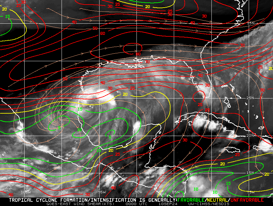
Not the best shear maps cause it's not really showing the storm well, will get better one. Will be interesting to see how she does plowing north east.
-
I was kinda assuming that since it become less joined.
-
The only question or possibly concern is: the whole fully separation of the 2 big cloud masses that's not showing right now and is that dry air north of or slightly north west of the center to? If it is will that be drawn into it later on?
-
I think What he's saying is, the cat 1 / cat 2 with a couple cat 3, estimates that we saw yesterday on some models at one point were over done. If it's a cat 1 borderline cat 2 that's reasonable, as of this morning...
-
-
Lower level water vapor Mid level water vapor Upper level water vapor (The first 2 maybe backwards just fyi)
-
Current Intensity Analysis UW - CIMSS ADVANCED DVORAK TECHNIQUE ADT-Version 9.1 Tropical Cyclone Intensity Algorithm ----- Current Analysis ----- Date : 10 SEP 2024 Time : 121020 UTC Lat : 24:41:55 N Lon : 96:04:15 W CI# /Pressure/ Vmax 2.3 /1001.6mb/ 33.0kt Final T# Adj T# Raw T# 2.2 2.6 2.7 Center Temp : -12.7C Cloud Region Temp : -47.5C Scene Type : CURVED BAND with 0.62 ARC in LT GRAY Subtropical Adjustment : OFF Extratropical Adjustment : OFF Positioning Method : FORECAST INTERPOLATION Ocean Basin : ATLANTIC Dvorak CI > MSLP Conversion Used : CKZ Method Tno/CI Rules : Constraint Limits : 0.5T/hour Weakening Flag : ON Rapid Dissipation Flag : OFF C/K/Z MSLP Estimate Inputs : - Average 34 knot radii : 92nmi - Environmental MSLP : 1010mb Satellite Name : GOES16 Satellite Viewing Angle : 37.1 degrees
-
-
-
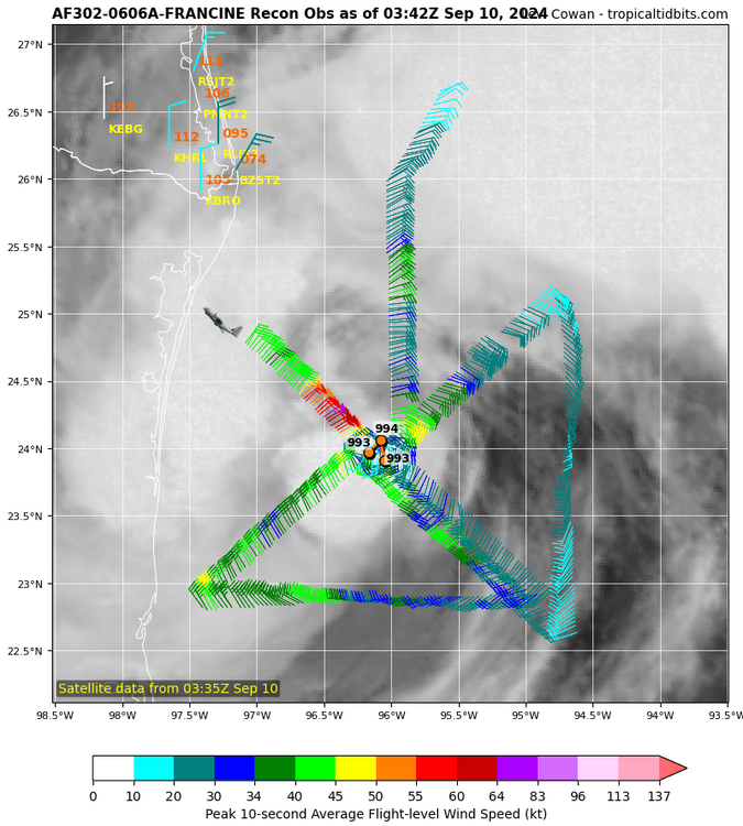
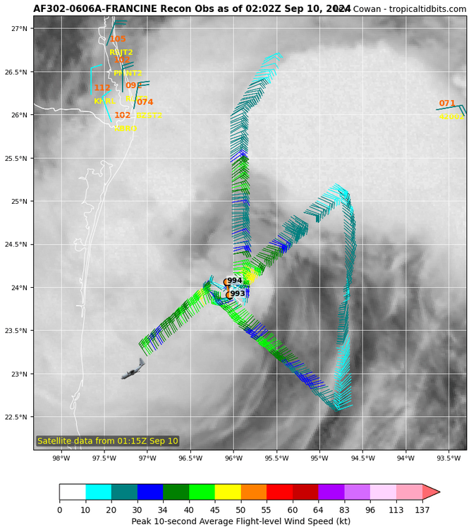
If the pressures keep dropping but winds don't respond similar to Ernesto, then I'd be concerned. All bets on the table now
-
After strengthening this afternoon, Francine's intensity appears to have leveled off for now. Around 18Z today, microwave images indicated that the storm had a closed low-level eyewall and a relatively symmetric cloud pattern. However, an intrusion of dry air has caused the inner core convection to degrade. The Air Force and NOAA Hurricane Hunter aircraft have been investigating Francine this evening and have found that the maximum winds have changed little from earlier and remain around 55 kt. However, the minimum pressure reported from the aircraft has dropped to 992 mb, which could indicate that strengthening will resume soon. The outer rainbands to the west and northwest of the center are very near the coast of northeastern Mexico and extreme southern Texas, and there are likely tropical-storm-force winds in those bands. Environmental conditions are forecast to remain quite favorable for strengthening along Francine's path for the next 24 hours, with very warm ocean waters while remaining in a low wind shear environment. The SHIPS RII index for rapid intensification over the next 24 hours has decreased a little due to some dry air in the environment around Francine. The NHC intensity forecast is similar to the previous one, and lies near the high end of the intensity guidance suite. Just prior to landfall, Francine should encounter increasing west-southwesterly vertical wind shear, which will likely end the intensification trend. Rapid weakening is expected after the storm moves inland.
-
Honestly, if the dry air story doesn't resolve itself, it maybe a now casting event... but it still has a day to get her butt in gear. 11pm update, speed held, movement speed down to 5 mph at north north west.. pressure is down to 992, somehow...
-
Like you said, everything is almost opposite what they were saying earlier, be interesting to see what they find at the 11 on update! With the forming inner-core earlier observed by recon and still seen on radar currently, the tropical storm appears poised to intensify more significantly in the short term. Given the low vertical wind shear, ample moisture, and very warm sea-surface temperatures, a faster rate of intensification is shown over the next 36 h, and Francine is now forecast to become a hurricane tonight or tomorrow morning, and a Category 2 hurricane by Wednesday. In the final 12-18 h before landfall, shear is expected to increase markedly, which will likely halt the intensification, though Francine is expected to be a Category 2 hurricane at landfall. Rapid weakening is expected after the system moves inland. The NHC intensity forecast is on the upper-end of the overall intensity guidance, but still is lower than some of the hurricane-regional model guidance (HAFS-B, HMON).
-
A lot of dry air to the north and also the west but the west side isn't easily shown. Weather channels talking in depth right now about it.
-
It's extremely close to the coast, an area that's been extremely hot all summer, and semi dryer environment ( I'm not totally sure on moisture levels to the west of the coast per say) . There's quite a bit of dry air to the north west of Francine too.. Look what happened to the storm that hit Bermuda, countless dry air that wasn't exactly forecasted, something very hard to perdict imo.
-
-
Former nhc guy on weather Channel speaks reality finally, dry air wrapping into storm, could affect intensity down the road possibly but will have to wait to see just what affect it has.
-
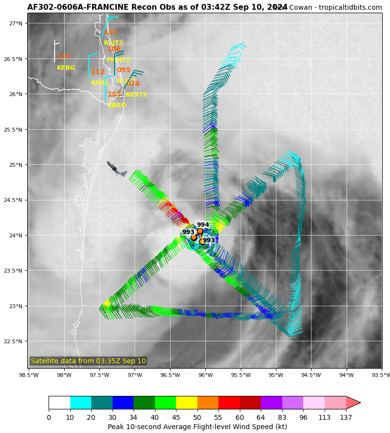
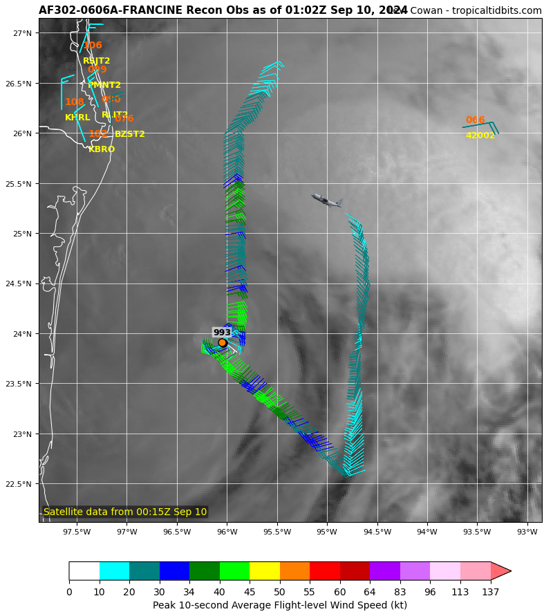
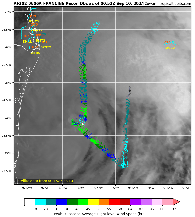
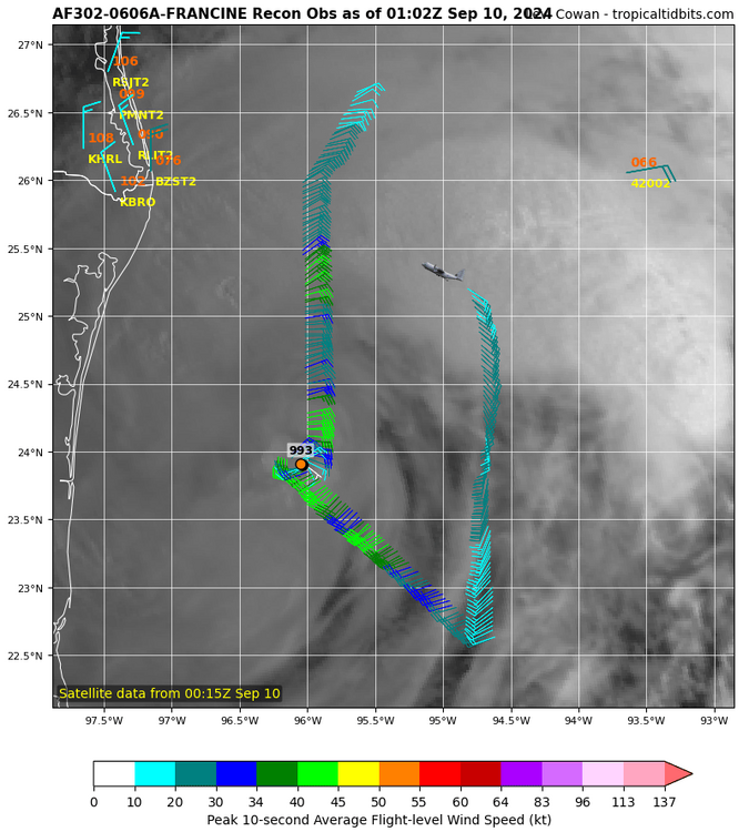
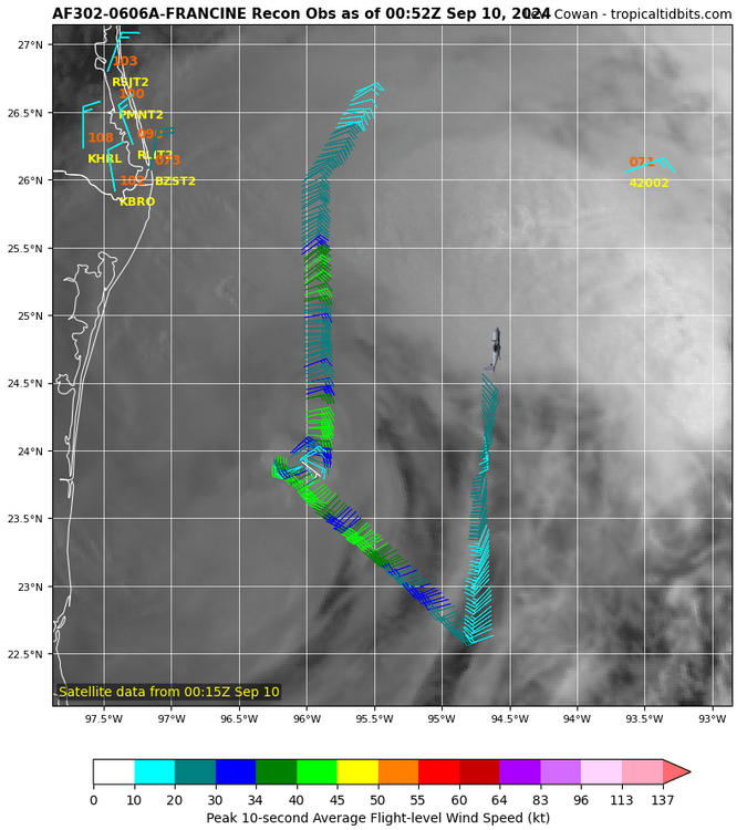
Last pass had best winds closest to center 45-50 knots close to 60 mph.
-
-
-
One planes using SFMR the other isn't. The one using has not seen good winds at all yet.. interesting as of right now, winds measured so far suggest 51 mphs max
-
Max winds found so far about 45knts south east section
-
AS of now winds are piss poor boring
-
Correction recon drops suggest 993-999 pressure so well wait to see