wthrmn654
-
Posts
3,953 -
Joined
-
Last visited
Content Type
Profiles
Blogs
Forums
American Weather
Media Demo
Store
Gallery
Everything posted by wthrmn654
-
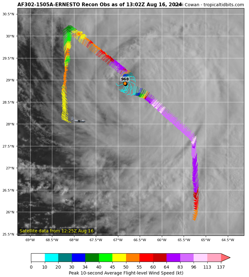
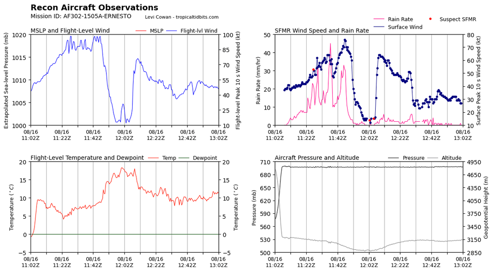
Might be trying to make an eye. Pressure rose a little 2mb. Looking at recon stuff.
-
He is still hauling asses without any slowdown lol I thought it would start to slow down by now
-
SUMMARY OF 200 PM AST...1800 UTC...INFORMATION ---------------------------------------------- LOCATION...30.0N 66.1W ABOUT 180 MI...285 KM SSW OF BERMUDA MAXIMUM SUSTAINED WINDS...100 MPH...155 KM/H PRESENT MOVEMENT...NNE OR 30 DEGREES AT 14 MPH...22 KM/H MINIMUM CENTRAL PRESSURE...969 MB...28.61 INCHES WATCHES AND WARNINGS -------------------- CHANGES WITH THIS ADVISORY: None. SUMMARY OF WATCHES AND WARNINGS IN EFFECT: A Hurricane Warning is in effect for... * Bermuda A Hurricane Warning means that hurricane conditions are expected somewhere within the warning area. Preparations to protect life and property should be rushed to completion. For storm information specific to your area, please monitor products issued by your national meteorological service. DISCUSSION AND OUTLOOK ---------------------- At 200 PM AST (1800 UTC), the center of Hurricane Ernesto was located near latitude 30.0 North, longitude 66.1 West. Ernesto is moving toward the north-northeast near 14 mph (22 km/h). This general motion is expected to continue with a gradual slowdown by Saturday. A faster northeastward motion is expected late this weekend into early next week. On the forecast track, the center of Ernesto is expected to pass near or over Bermuda on Saturday morning. Maximum sustained winds remain near 100 mph (155 km/h) with higher gusts. Some gradual weakening is forecast over the next day or so, though some re-intensification is possible by early next week. Ernesto remains a large tropical cyclone. Hurricane-force winds extend outward up to 75 miles (120 km) from the center, and tropical-storm-force winds extend outward up to 275 miles (445 km). Saildrone SD-1068 located about 55 miles (90 km) north-northeast of Ernesto's center, recently reported a sustained wind of 58 mph (94 km/h), with a gust up to 74 mph (119 km/h). The minimum central pressure based on data from both Air Force and NOAA Hurricane Hunter aircraft is 969 mb (28.61 inches).
-
-
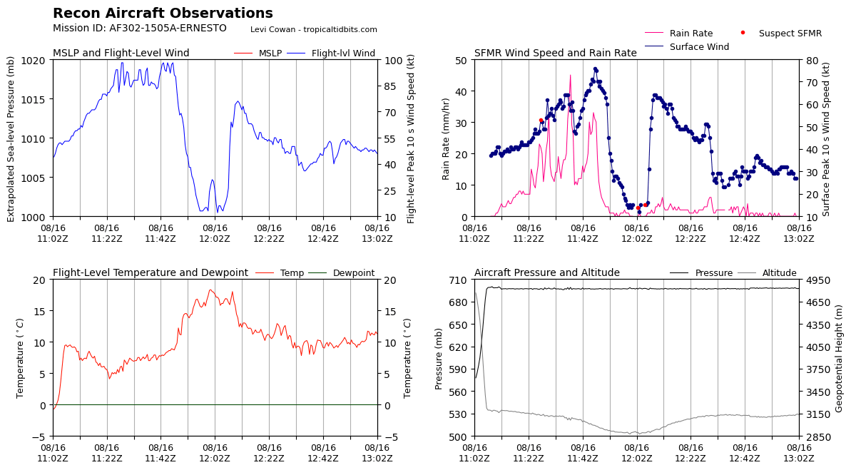
They kinda found an eye earlier lol? NWS National Hurricane Center Miami FL AL052024 1100 AM AST Fri Aug 16 2024 Ernesto appears to be feeling the effects of vertical wind shear this morning. The structure on satellite has become more asymmetric with the coldest cloud tops shifted to the east of the center fixes being made by an ongoing Air Force Hurricane Hunter mission, which also found a 50-mile-wide eye open to the southwest. Despite the degraded satellite appearance, the aircraft still found 700-mb flight-level winds up to 98 kt, with peak SFMR-derived winds of 76 kt in the southeast quadrant of Ernesto. A blend of these data still supports an intensity of 85 kt this advisory, though this could be generous. The hurricane remains quite large with tropical-storm-force winds extending up to 240 n mi southeast of the center. Ernesto continues to move north-northeast, estimated at 330/12 kt. The deep-layer trough that has been initially influencing Ernesto's motion is already starting to leave the tropical cyclone behind, and the track guidance indicates the hurricane will begin to slow its forward motion over the next day or so while continuing to move north-northeastward. After that time, another shortwave trough currently over the upper Midwest U.S. is forecast to dig southeastward, which should ultimately result in Ernesto accelerating northeastward around the periphery of the subtropical ridge to its southeast. The track guidance this cycle is quite close to the prior forecast, and the NHC track forecast only has minor changes compared to the previous cycle. Vertical wind shear diagnosed by SHIPS guidance is already up to 25 kt or greater, and this shear is likely to persist for another 12 to 24 h. Thus the latest NHC intensity forecast now shows a little more weakening, though it should be noted some of the hurricane regional models show Ernesto weakening below hurricane intensity over the next 36 h. Thereafter, as the first trough bypasses the system, the forecast shear decreases while the tropical cyclone remains over 28 C or warmer sea surface temperatures. Thus, there remains an opportunity for Ernesto to re-intensify before it reaches the north wall of the Gulf Stream by early next week. However, extratropical transition will likely be underway shortly after it crosses over much cooler waters after 72 h, with the latest NHC forecast showing the system becoming extratropical at 96 h.
-
Noaa plane showing 967mb.. wtf This is like a zombie cane
-
2nd recon pass suggest pressure is up to 971.
-
It would appear/ seem that its going north east, does it go to the south/ east of Bermuda?
-
-
34knts 50knts 64knts
-
Noaa 49, noaa 43 are en route with teal somewhere in the storm can't pick him up on flight tracking sadly
-
This storm is just so backwards and confusing with the pressure drops yet semi crazy winds on only half of it lol.
-
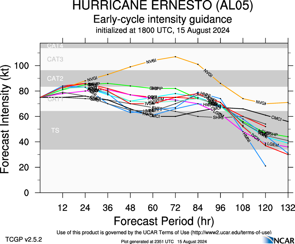
500 AM AST Fri Aug 16 2024 Ernesto's strengthening trend has seemingly halted overnight. The cloud pattern near the center has become less organized, and the system appears to be struggling with dry air again with some eyewall erosion in the western semicircle. Still, the convective banding in the eastern side where the previous aircraft mission found the peak winds remains deep and well-defined, suggesting that Ernesto hasn't lost much strength. The initial wind speed is kept at 85 kt for this advisory, a bit above the latest satellite estimates, pending the upcoming Air Force Reserve Hurricane Hunter aircraft mission this morning. The environment near Ernesto could support some strengthening today. However, the most noticeable change in the overnight intensity guidance aids is that almost all of them are showing more shear today than previously expected. This shear, combined with the environmental dry air, has led to this cycle's intensity forecast values being a lot lower than 6 h ago. Given current trends, the NHC prediction has been decreased from the last forecast, and is still on the high side of the guidance. It is worth noting that despite the peak wind speed reductions, the forecast size is generally larger than the previous forecast, so the life-threatening hazards from Ernesto are unchanged. After the hurricane passes Bermuda, there could be a brief window for some re-intensification in lighter shear conditions plus favorable trough influences before Ernesto crosses into cool waters, and little change was made at longer range.
-
The fact that the dry air was persistent for 24hrs was red flag#2. Red flag#1 was the extremely far movement, I without a doubt think has it been moving gals of its speed orginally say 7,8 mphs, it would of also been able to explode and erode the dry air. That thing was moving so fast, kept getting into New dry air it would seem around the time it finally absorbed and was getting is act better.
-
Years ago I thought there was a saying about one of the letters in the alphabet of names being one that's not good with tropical systems. Lol it may of been the letter E storms None the less, Ernesto tropical career has been one that was never really successful only 2 times if i remember the wiki Stat from yesterday,did it became a cane.
-
-
I swear it looks like that front is taking it north east faster..
-
It picked up 1 mph sped Movement wise lol
-
NWS National Hurricane Center Miami FL AL052024 1100 PM AST Thu Aug 15 2024 Ernesto has been strengthening this evening. Data from an Air Force Hurricane Hunter aircraft indicate that the minimum pressure has fallen to about 968 mb, and a blend of the peak flight-level and SFMR winds support increasing the initial intensity to 85 kt. This makes Ernesto a category 2 hurricane on the Saffir-Simpson Hurricane Wind Scale. Ernesto has a ragged eye and a large wind field, with the highest winds occurring in the northeast quadrant. Ernesto is moving north-northeastward at 12 kt in the flow between a high pressure system over the central Atlantic and a large-scale trough off the U.S. east coast. This general motion is expected to continue for the next day or two, bringing the hurricane near or over Bermuda on Saturday. Around that time, the trough is expected to lift out, leaving Ernesto in weaker steering currents. As a result, a slower and likely more erratic motion to the north or north-northeast is forecast over the weekend. Another trough is expected to approach the cyclone late in the weekend, and that should cause an accelerated motion to the northeast near or east of Atlantic Canada early next week. The NHC track forecast is a touch to the east and a little slower than the previous one through its passage near Bermuda to come into better agreement with the latest consensus aids. It seems likely that Ernesto will strengthen some more during the next 12 to 24 hours as it is expected to remain in conducive environmental conditions of low wind shear, upper-level diffluence, a relatively moist airmass, and over warm waters during that time. Thereafter, increasing vertical wind shear and gradually cooler waters should cause a slow weakening trend. However, baroclinic influences could offset some of the weakening, which is why the official forecast shows little change in strength during the 48- to 72-hour time frame. Ernesto is forecast to complete extratropical transition by day 5, when it will likely be embedded within the mid-latitude westerlies. The NHC intensity forecast lies near the high end of the guidance, in best agreement with the HCCA model.
-
I saw that as well, they were flying into a deep explosive cluster of storms when that was being recorded too
-
-
Amazing how it's still dropping pressure yet taking on air, but luckily winds aren't going crazy power say. With that said recon may of gotten a couple samples while it was firing up again. May just be night time throwing a twist but it looks like it's a little smaller.?
-

-
8 pm update 90 mph.
-
The lack of lightening around the center on sat tracking is just weird. Usually there's tons of thunderstorms around a good center. Found a Advected Layer Precipitable Water map.