wthrmn654
-
Posts
3,953 -
Joined
-
Last visited
Content Type
Profiles
Blogs
Forums
American Weather
Media Demo
Store
Gallery
Everything posted by wthrmn654
-
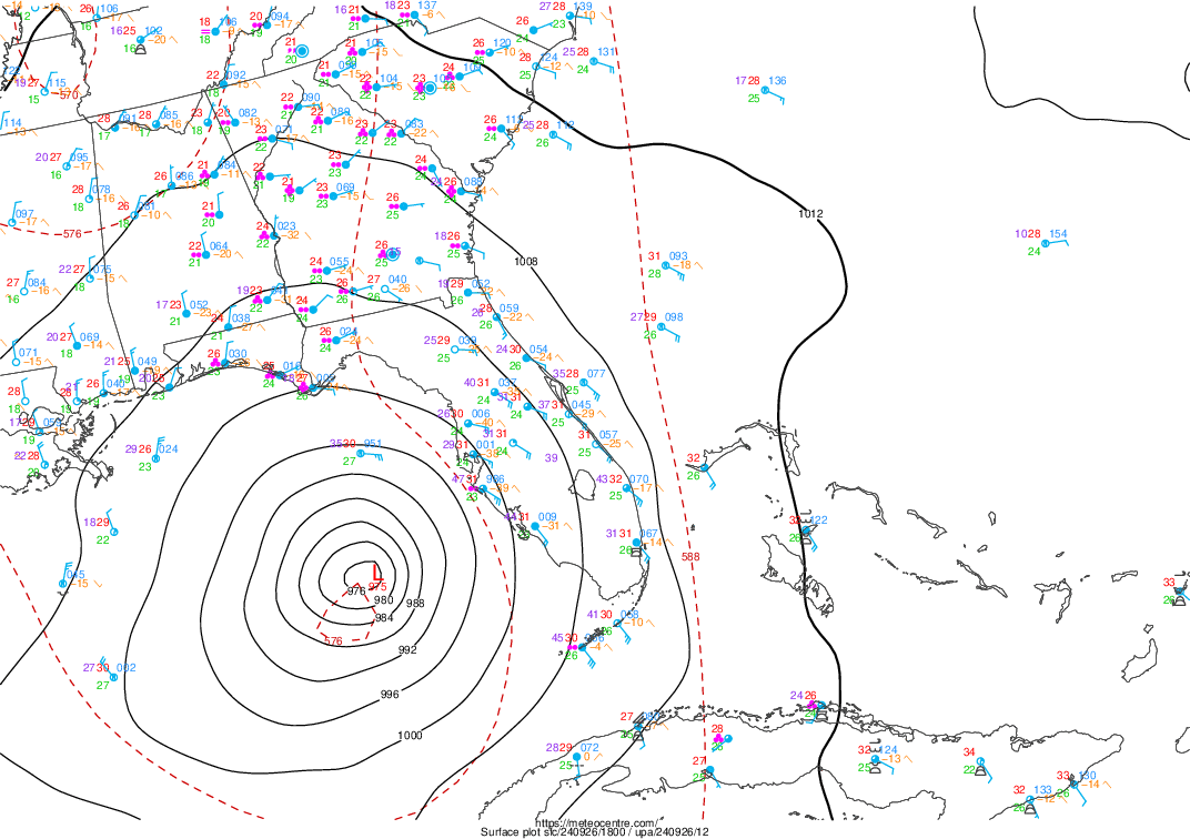
Flight level winds 113-137 knots if I have my colors correct on the recon map?! Jeez And lowest pressure I could see was 946.2mb
-
Wow satellite pressure estimates were 930 or 940 something and I thought they were crazy.. but recon finding 946... matches the recon findings fairly well. Current Analysis ----- Date : 26 SEP 2024 Time : 211020 UTC Lat : 27:33:35 N Lon : 84:25:48 W CI# /Pressure/ Vmax 6.2 / 931.5mb/119.8kt Final T# Adj T# Raw T# 6.2 6.1 6.1 Estimated radius of max. wind based on IR :N/A km Center Temp : -21.9C Cloud Region Temp : -69.7C Scene Type : EYE
-
No worries per buoy site there's no buoys in gulf measuring that high
-
946ish too! It flew east and it was going down
-
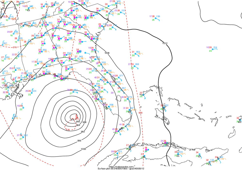
As of 09/26/2024 17:00 EDT, water levels along the Florida Gulf Coast are elevated and continuing to rise as Hurricane Helene approaches. Below is a breakdown of water level observations above normal tide levels by region: Pensacola, FL to Apalachicola, FL.... 1.6 to 3.5 feet Apalachicola, FL to Tampa Bay, FL....3.5 to 3.9 feet Tampa Bay, FL to Key West, FL......1.6 to 3.7 feet Winds along the south and southeastern Florida coast from Key West to Lake Worth Pier presently range between 25 and 35 knots with gusts to 40 knots. Winds from Key West to Cedar Key range between 25 and 40 knots with gusts to 50 knots. Winds along the Florida Panhandle from Pensacola to Apalachicola range between 10 and 15 knots with gusts to 20 knots.
-
I assumed that, but I only see 20 foot seas so maybe I'm missing something
-
31? Which buoy is that by chance the one that's less then 31 miles away is showing 20 feet now
-
Buoy nearing the eye pressure is now dropping fast, -0.35 inches currently at 985.4mb sustained windabout 40 knots gusts nearly 60 knots. Wave height close to 20 feet now.
-
Latest ADT satellite estimate shows 115knot max now which translates to 132mph
-

2024 Atlantic Hurricane Season
wthrmn654 replied to Stormchaserchuck1's topic in Tropical Headquarters
Busy times ahead for all you mets! We thank you all for all the schooling and learned knowledge as well as being patient with us average humans of the USA lol -
I was going say looking at the recon positions of the center and the noaa buoys to the north if would seem instead of going to the right of the buoy is going be going to the left of it instead. But as goose pointed out wobbles and such could make it an unknown variable
-
OK , it was a couple of satellite views of different modes and it's not every 15 mintues.
-
-
Kinda looks like an eye is trying to clear out now
-
Whoever said recon found that low pressure, drop sonde says 952
-
She's getting stronger! Current Analysis ----- Date : 26 SEP 2024 Time : 191020 UTC Lat : 26:49:47 N Lon : 84:44:23 W CI# /Pressure/ Vmax 5.4 / 949.1mb/ 99.6kt Final T# Adj T# Raw T# 5.4 6.3 6.3 Estimated radius of max. wind based on IR :N/A km Center Temp : -8.1C Cloud Region Temp : -70.8C Scene Type : EYE Subtropical Adjustment : OFF Extratropical Adjustment : OFF Positioning Method : ARCHER POSITIONING Ocean Basin : ATLANTIC Dvorak CI > MSLP Conversion Used : CKZ Method Tno/CI Rules : Constraint Limits : NO LIMIT Weakening Flag : OFF Rapid Dissipation Flag : OFF C/K/Z MSLP Estimate Inputs : - Average 34 knot radii : 182nmi - Environmental MSLP : 1007mb Satellite Name : GOES16 Satellite Viewing Angle : 33.0 degrees
-
Things booking now at 20 mph
-
Hurricane Helene Tropical Cyclone Update NWS National Hurricane Center Miami FL AL092024 300 PM EDT Thu Sep 26 2024 ...STORM SURGE AND WINDS INCREASING ALONG THE FLORIDA WEST COAST... ...300 PM EDT POSITION UPDATE... A Weatherflow station at Egmont Channel at the entrance to Tampa Bay recently measured a sustained wind of 50 mph (80 km/h) and a gust to 62 mph (100 km/h). SUMMARY OF 300 PM EDT...1900 UTC...INFORMATION ---------------------------------------------- LOCATION...26.9N 84.8W ABOUT 160 MI...255 KM WSW OF TAMPA FLORIDA ABOUT 195 MI...315 KM S OF APALACHICOLA FLORIDA MAXIMUM SUSTAINED WINDS...120 MPH...195 KM/H PRESENT MOVEMENT...NNE OR 25 DEGREES AT 20 MPH...31 KM/H MINIMUM CENTRAL PRESSURE...959 MB...28.32 INCHES
-
-
About 129nm north waves are at or above 18 feet, winds gusting nearly 65mph. Add insult to injury, high tide is roughly around 100 am , so anyone down there keep in mind that week play a big role in how high tide actually get in all coastal areas
-
Of more shock, if this gets to as strong as several of the hurricane models had showed days ago, and we all were saying there not very good until the system is somewhat more organized, that's impressive for a system that hadn't even gotten a name let alone is core well defined / formed
-
Curious, just was looking at total precipitatable water, that less colored spiral getting wrapped around the western flank, is that anything that would affect weakening/ strengthening at this point? EDIT: just noticed time stamp is a few hours old.
-
This may also go towards what you guys were saying..
-
-
Last thing for a while but, best visual comparison... look at how big that blue wind field line is jeez! https://tidesandcurrents.noaa.gov/inundationdb/?sw=17.49739,-89.05518&ne=34.02535,-78.28857&layers=111111111000