WintryMixmaster
-
Posts
113 -
Joined
-
Last visited
Content Type
Profiles
Blogs
Forums
American Weather
Media Demo
Store
Gallery
Everything posted by WintryMixmaster
-
Jan 30th-February 1st 2026 Arctic Blast/ULL Snow OBS Thread.
WintryMixmaster replied to John1122's topic in Tennessee Valley
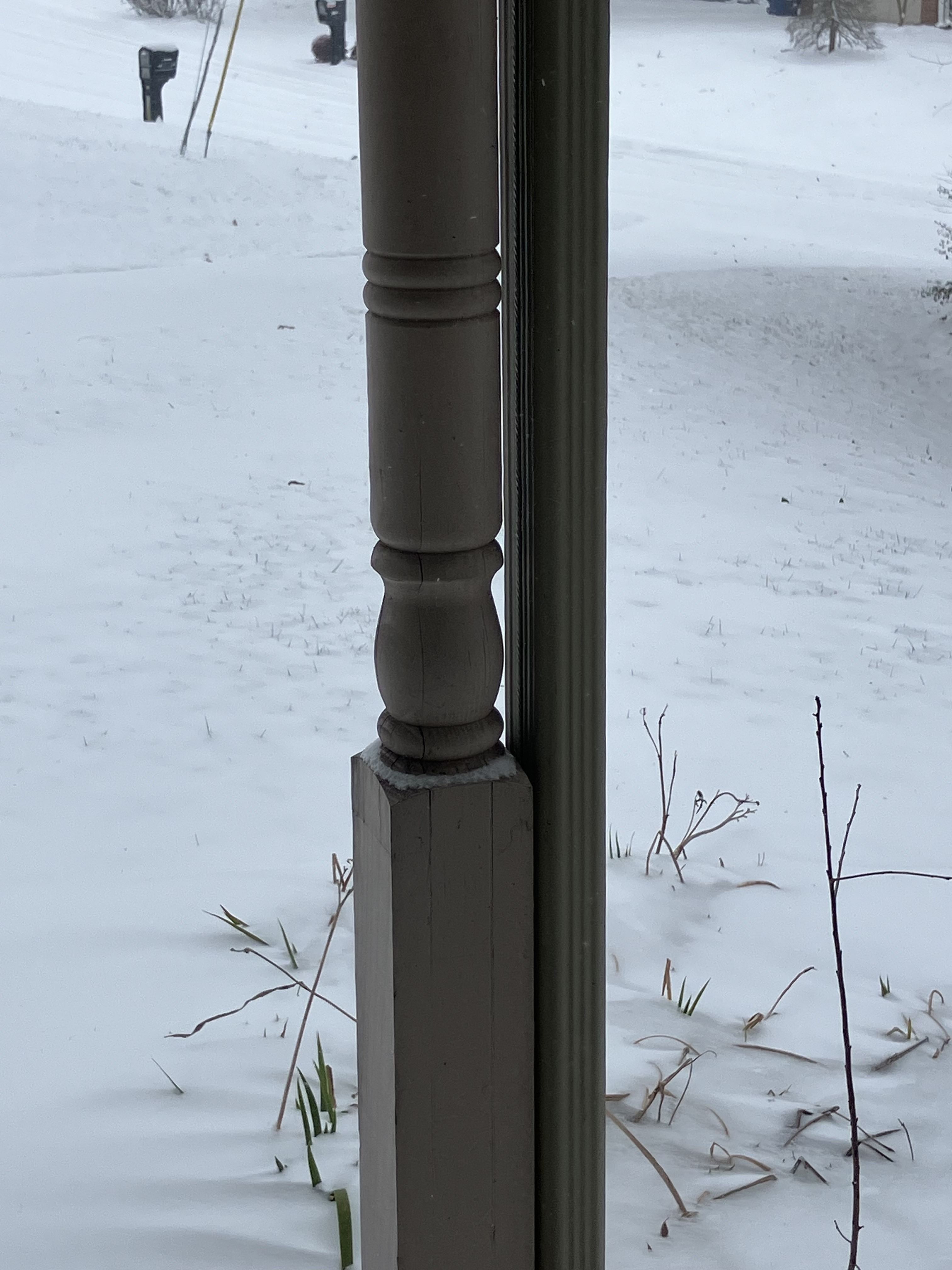
Light snow still falling here but at this point I think we're about done as far as accumulation goes. Measured 3.7 inches which was almost dead on with what most of the models had predicted for my backyard, snowfall gradient and all. It was nice to see the foothills and NE TN get a good storm and that the whole valley seemed to get at least some snow -
Jan 30th-February 1st 2026 Arctic Blast/ULL Snow OBS Thread.
WintryMixmaster replied to John1122's topic in Tennessee Valley
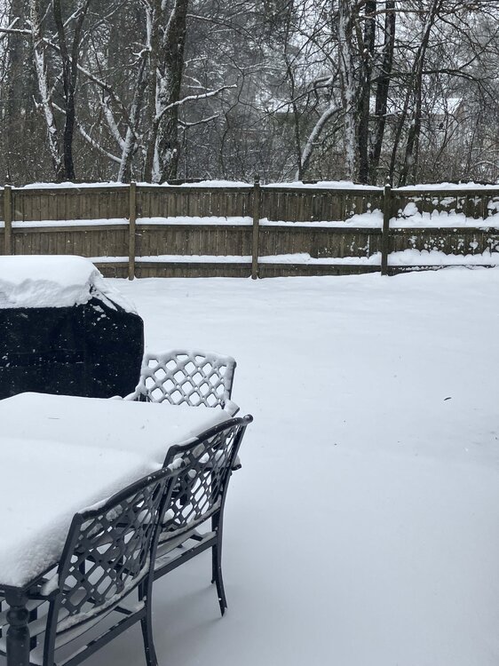
My front yard says "what storm?" (trees to the north block the snow). Meanwhile my backyard has a drift almost a foot deep up against the fence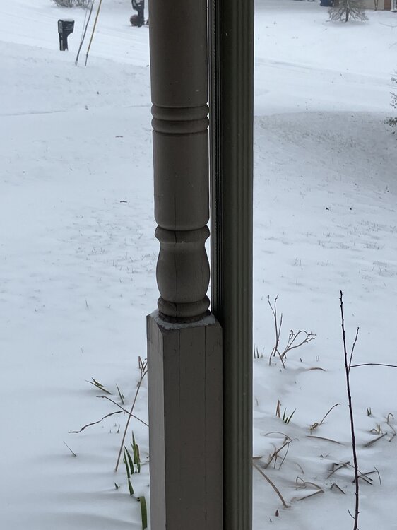
-
Jan 30th-February 1st 2026 Arctic Blast/ULL Snow OBS Thread.
WintryMixmaster replied to John1122's topic in Tennessee Valley
Another 1-2" seems generous but possible if we get a band and a period of more moderate snowfall rates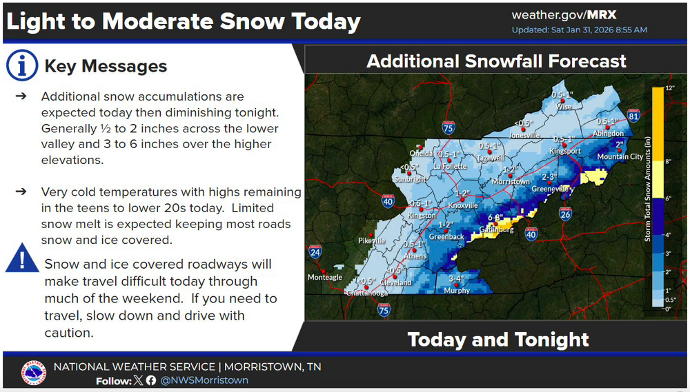
-
Jan 30th-February 1st 2026 Arctic Blast/ULL Snow OBS Thread.
WintryMixmaster replied to John1122's topic in Tennessee Valley
Almost impossible to measure accurately with the blowing, compaction, and drifting, but I'd guess 3.5 inches +/- 0.5 inch in my yard. Steady at 15.1 degrees and light snow falling. Not sure how much more I can reasonably expect unless we get a period of heavier snow, the light powder is blowing away as fast as its falling -
Jan 30th-February 1st 2026 Arctic Blast/ULL Snow OBS Thread.
WintryMixmaster replied to John1122's topic in Tennessee Valley
I went to college in Minnesota and this reminds me of a Minnesota snow - dry, light powder that almost sparkles in the light -
Jan 30th-February 1st 2026 Arctic Blast/ULL Snow OBS Thread.
WintryMixmaster replied to John1122's topic in Tennessee Valley
What site do you use for radar? -
Jan 30th-February 1st 2026 Arctic Blast/ULL Snow OBS Thread.
WintryMixmaster replied to John1122's topic in Tennessee Valley
I wish I lived in the northern part of the county lol, I have around 3 inches on the grass and 2-3 on other surfaces. It looks like most of the accumulation happened before around 4:30 AM, we've had significantly lighter rates after that. HRRR does show another pulse of more moderate snow hitting us later this morning, which may be needed if the total is going to hit 4" in my backyard -
Jan 30th-February 1st 2026 Arctic Blast/ULL Snow OBS Thread.
WintryMixmaster replied to John1122's topic in Tennessee Valley
Radar shows the moderate to heavy rates over Blount County now, not sure if any of those bands are expected to redevelop over Knox. A few more hours of the current light snow would probably get us to the forecasted 3-5" range though Temperature has dropped to 18.3 degrees since my last post just 20 minutes ago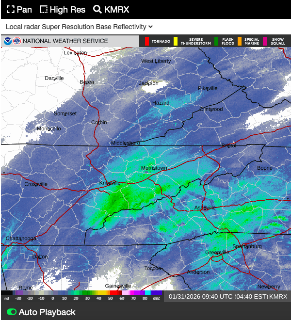
-
Jan 30th-February 1st 2026 Arctic Blast/ULL Snow OBS Thread.
WintryMixmaster replied to John1122's topic in Tennessee Valley
Wind is picking up too, temperature is down to 19.2 degrees with moderate snow, oscillating between lighter and heavier -
Jan 30th-February 1st 2026 Arctic Blast/ULL Snow OBS Thread.
WintryMixmaster replied to John1122's topic in Tennessee Valley
Some solid very fluffy snow falling here, a mixture of small snowflakes and larger nickel-sized ones blowing in the wind. Feels very Christmas-y! 2 inches on the ground -
Jan 30th-February 1st 2026 Arctic Blast/ULL Snow OBS Thread.
WintryMixmaster replied to John1122's topic in Tennessee Valley
I feel like the timing of this storm was really lucky... with such light/moderate rates over a long period, I feel like the sun angle could've eaten a good chunk of our totals had this hit during the day even with the cold temps. But with the bulk of the remaining snow arriving for Knox County between 2 AM and noon, we should've have to worry about that (just have to worry about that sharp gradient wherever it ends up setting up shop). I think I'm going to set an alarm for 4 am or so and check back in then to see how things are progressing, the light snow has tapered to flurries in my backyard at the moment with 0.3" on the ground so far -
Jan 30th-February 1st 2026 Arctic Blast/ULL Snow OBS Thread.
WintryMixmaster replied to John1122's topic in Tennessee Valley
The last HRRR has us actually getting no snow at the moment (it's still coming down lightly at my house), and building back to our side of town around 2 AM and hanging around through 2 PM, with 3-4" on top of what we already have. Which I think would put us about on schedule for the median model result for our area -
Jan 30th-February 1st 2026 Arctic Blast/ULL Snow OBS Thread.
WintryMixmaster replied to John1122's topic in Tennessee Valley
I feel like I remember looking at the simulated radar last night and watching it look exactly like that, but then slowly filling in to the west and being like "I need to remind myself tomorrow not to panic and that when the ULL gets closer, the snow will pick up" ... now that I said that, watch that just end up being the cutoff haha -
Jan 30th-February 1st 2026 Arctic Blast/ULL Snow OBS Thread.
WintryMixmaster replied to John1122's topic in Tennessee Valley
Growing up, I remember staying up late and watching the radar and the rain/slow line creep towards my backyard, setting an alarm for 3 am or whenever the changeover was supposed to occur, and going out to measure right beforehand. My mom (who had to get up at 6 am for work) absolutely hated it, but I had the most accurate snowfall measurement around! haha The fact that snow is more rare here actually makes it even more magical. It really feels like every second of it is special and I just want to look out the window and daydream -
Jan 30th-February 1st 2026 Arctic Blast/ULL Snow OBS Thread.
WintryMixmaster replied to John1122's topic in Tennessee Valley
Yeah I think most modeling showed light snow before midnight and after 10 am or so tomorrow, and most of our accumulation came from the midnight to 10 am period. The question is, do I stay up late to see it or do I get up early? Or do I just make some more coffee and go from there? haha -
Jan 30th-February 1st 2026 Arctic Blast/ULL Snow OBS Thread.
WintryMixmaster replied to John1122's topic in Tennessee Valley
Just got home from South Knoxville... definitely a snowfall gradient over the area as expected. Maybe a little over an inch there, but here in west Knox we're at about a quarter inch so far -
1-30/2-1-26 Arctic Blast, ULL Snow Event
WintryMixmaster replied to John1122's topic in Tennessee Valley
It seems kind of like the RGEM/Canadian have come down a bit from their highs, but the other models have met them like 80% of the way there. I feel like the main inconsistent thing is how sharp is the gradient on and west/south of Knoxville. Some models like the RGEM have 3-6" back to the plateau, others like the NAM seem to have a much sharper cutoff with low totals on the Plateau and really shafting that Oak Ridge-Harriman area -
1-30/2-1-26 Arctic Blast, ULL Snow Event
WintryMixmaster replied to John1122's topic in Tennessee Valley
The NBM also seemed to significantly lag the trends with the last storm... when Morristown put out that first call snowfall map with 7" for Knoxville despite the fact that other than the GFS, no model had shown that in multiple suites, I realized they probably just copy/pasted the NBM- 782 replies
-
- 2
-

-
- extreme cold
- snow
- (and 1 more)
-
1-30/2-1-26 Arctic Blast, ULL Snow Event
WintryMixmaster replied to John1122's topic in Tennessee Valley
Canada is trying to get our hopes up with those RGEM+CMC runs. I'd take the 3" from the GFS and run at this point though -
1-30/2-1-26 Arctic Blast, ULL Snow Event
WintryMixmaster replied to John1122's topic in Tennessee Valley
The high res models, though at the end of their ranges, all very much dislike this storm for East Tennessee. RRFS, NAM 3k, HRW FV3, even the NAM to some extent. I don't like that so I'll choose to ignore them- 782 replies
-
- 1
-
-
- extreme cold
- snow
- (and 1 more)
-
January 2026 Short/Medium Range Thread
WintryMixmaster replied to John1122's topic in Tennessee Valley
If the main mechanism to provide lift is the saturated air rising under the 500 mb low and hitting the Plateau/Smokies, should we expect a more distinct area of lower snow totals up the center of the valley? The GFS has a bit of one but it ends just SW of Oak Ridge. Would a higher resolution model probably sharpen that gradient and lower totals from Knoxville northeast along the valley floor?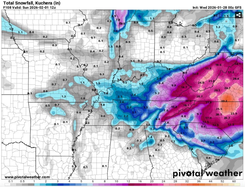
-
January 2026 Short/Medium Range Thread
WintryMixmaster replied to John1122's topic in Tennessee Valley
Is that burnt popcorn for Knoxville I smell? My warm nose can smell it in the air -
January 2026 Short/Medium Range Thread
WintryMixmaster replied to John1122's topic in Tennessee Valley
What if it's the bad kind of monster, like east TN gets warm nosed somehow but Jacksonville gets a foot of snow lol -
January 2026 Short/Medium Range Thread
WintryMixmaster replied to John1122's topic in Tennessee Valley
Weird how it pulled west from 12z but also went out to sea faster and ended up much worse for PA, NJ, and NY. I thought for sure it was going to crawl up the coast -
January 2026 Short/Medium Range Thread
WintryMixmaster replied to John1122's topic in Tennessee Valley
These kinds of posts are great for people like me (I only have a vague idea of how to interpret the 500 mb maps, I never know what the important features are on these). Thank you!