
Lava Rock
-
Posts
11,659 -
Joined
-
Last visited
Content Type
Profiles
Blogs
Forums
American Weather
Media Demo
Store
Gallery
Posts posted by Lava Rock
-
-
9 minutes ago, RUNNAWAYICEBERG said:
Away from the water? I haven’t.
Wolfie is probably licking his wounds and loading his sleigh onto his truck…heading north for the season realizing this is not what a mid Dec storm should look like in Southington CT USA.
he'll need to go well into CAN to find anything rideable .
-
Only 4486 w/out power, all in Androscoggin county. I'm sure that'll increase a lot by noon.
-
16 minutes ago, 40/70 Benchmark said:
"Please be seated passengers and note the fasten seatbelt sign as we expect some turbulence dodging and weaving dog logs upon landing"....
must be pretty choppy landing/taking off at BOS
-
Lost internet. Since my davis communicates via wifi and I don't use my console anymore, can't capture the wind gusts.
Sent from my SM-G981U1 using Tapatalk-
 1
1
-
-
1.8". Powered flickered
Sent from my SM-G981U1 using Tapatalk -
Nice cell over the homestead

Sent from my SM-G981U1 using Tapatalk -
RN has commenced. 39.6F
Sent from my SM-G981U1 using Tapatalk -
4-6" rn with locally higher amounts for some of the maine mtns. Terrible for the resorts
Sent from my SM-G981U1 using Tapatalk -
Did you issue the latest AFD? 4-6" rn for mtns, with locally higher amounts. Ski areas are forkedIf it's not HWW, you're forecasting under 30 mph.
BOX forecasters on the night shift:

Sent from my SM-G981U1 using Tapatalk
-
Is that stove pipe supported?Having some fun time before it gets washed down the Ammonoosuc
Sent from my SM-G981U1 using Tapatalk
-
We will rebuild30-45mph wind gust, So scary.
Sent from my SM-G981U1 using Tapatalk
-
 1
1
-
-
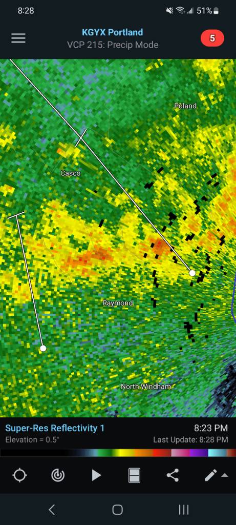
Alaska stealing all the sn
Sent from my SM-G981U1 using Tapatalk -
48F. Short sleeve wx
Sent from my SM-G981U1 using Tapatalk -
11 minutes ago, Damage In Tolland said:
Wildness
As for wind gusts potential and power outage potential, it will
come down to low level lapse rates and how well the boundary will
mix. Given this system is rapidly intensifying, it will be
accompanied by a strong pressure rise/fall couplet that will enhance
the wind threat.  Wind and rainfall/flood threats will ultimately
hinge on the exact track of the low level circulation and
accompanying low level jet, which currently ranges from eastern
PA/NJ into the Lower Hudson River Valley, to eastward into the CT
River Valley. Too early to pin down these details, but the potential
is there for a high impact event. Over the weekend we will likely be
able to add these details to the forecast. Greatest impacts from
this upcoming storm will be felt here in SNE from Sunday night into
Monday. Some headlines will likely be issued later tonight or Sat.
I'll enjoy the 5-10mph breeze here
-
3
-
 1
1
-
-
Gorgeous out. 46F
Sent from my SM-G981U1 using Tapatalk-
1
-
 1
1
-
-
7 minutes ago, ORH_wxman said:
12/22-23 was a big rainer for all of New England.
not sure why I don't recall it as I remembered last year as one of the 1st years in awhile we didn't have a grinch storm, but must have been thinking of another time. I hesitated pressing the submit button cause I wasn't 100% sure, but figured someone would correct me. Looks like we got 2.63" rn on the 23rd. Carry on....

-
34 minutes ago, alex said:
No worse than last year lol
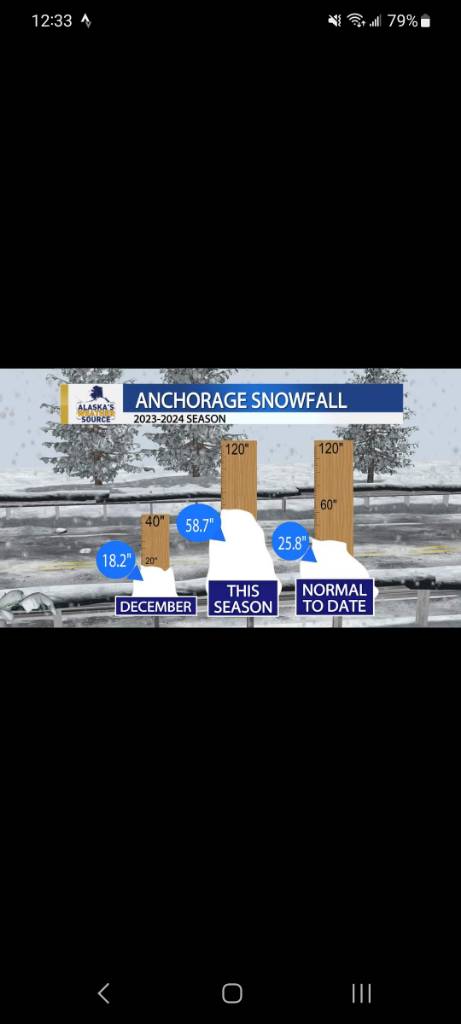
really? We had a 15" storm middle of Dec that I'm sure the mtns got close to that, but don't recall. There were no rainers last Dec either, so it seems this Dec would be worse for the resorts despite the good start, no?
-
51 minutes ago, Damage In Tolland said:
10 day fantasies aside.. still some guidance offering some backside snows after the cutter to Quebec City . ULL lingers behind some energy . That’s our most realistic hope for anything prior to Xmas.
close the shades. looks terrible
-
1
-
 1
1
-
-
38kts. Big whoop, we'll survive18z GFS takes forests down from SC to Maine
Sent from my SM-G981U1 using Tapatalk
-
1
-
-
a few mood flakes outside my work window
-
33 minutes ago, RUNNAWAYICEBERG said:
2-3” of rain during the cold season is about avg these days .
Very festive
-
1
-
-
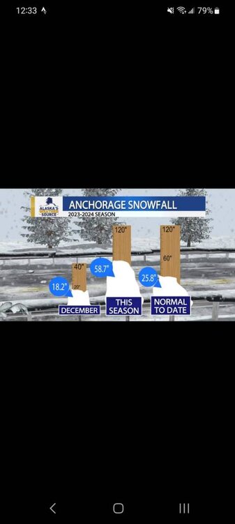
8 minutes ago, MegaMike said:
The units are mm/hr, not inches/hr.
TY, didn't catch that. We'll assume a few inches at least
-
1
-
1
-
-
22 minutes ago, tamarack said:
Farmington co-op had 10" come down on December 26-27/1969 (though it's a bit suspicious as no one else in the region had more than about 7"). Started with 15" SN then poured as temp rose to 50°. Was also BTV's top snowfall until 2010 topped it.
Nice to see a sunny day, with modest temps.
15" SN then 10" rn. what a mess that must have been
-
2 hours ago, Damage In Tolland said:
GGEM rips the tempest right thru heart of SNE knocking down whole forests on its way NNE.

10" rain.
 okie dokie
-
1
-
Sunday, December 17 - Monday, December 18, 2023 Storm
in New England
Posted
Anxiously waiting while in my work cube. Most of our freezers and overhead is on genny, but production equip is not. Today is a big shipping day too.