
BarryStantonGBP
-
Posts
786 -
Joined
-
Last visited
Content Type
Profiles
Blogs
Forums
American Weather
Media Demo
Store
Gallery
Everything posted by BarryStantonGBP
-

2025 Atlantic Hurricane Season
BarryStantonGBP replied to BarryStantonGBP's topic in Tropical Headquarters
Season cancel -
2025 Atlantic Hurricane Season
BarryStantonGBP replied to BarryStantonGBP's topic in Tropical Headquarters
-
2025 Atlantic Hurricane Season
BarryStantonGBP replied to BarryStantonGBP's topic in Tropical Headquarters
hemp -
2025 Atlantic Hurricane Season
BarryStantonGBP replied to BarryStantonGBP's topic in Tropical Headquarters
new bread made: -
2025 Atlantic Hurricane Season
BarryStantonGBP replied to BarryStantonGBP's topic in Tropical Headquarters
-
2025 Atlantic Hurricane Season
BarryStantonGBP replied to BarryStantonGBP's topic in Tropical Headquarters
s2k users yapping, but these are good points MarioProtVI Category 4 Posts: 946 Age: 24 Joined: Sun Sep 29, 2019 7:33 pm Location: New Jersey Re: 2025 Indicators: SST's, MSLP, Shear, SAL, Steering, Instability (Day 16+ Climate Models) #517 by MarioProtVI » Sat Aug 16, 2025 10:38 am Atlantic beating WPac once again to the punch in getting a Cat 5 3 likes Top Teban54 Category 5 Posts: 3241 Joined: Sat May 19, 2018 1:19 pm Re: 2025 Indicators: SST's, MSLP, Shear, SAL, Steering, Instability (Day 16+ Climate Models) #518 by Teban54 » Sat Aug 16, 2025 12:33 pm Something something cool MDR, something something warm subtropics inducing stability: (15-day mean chosen to reduce the effects of Erin's cold wake) Something something inactive deep tropics: 5 likes Top Category5Kaiju Category 5 Posts: 4144 Joined: Thu Dec 24, 2020 12:45 pm Location: Seattle Re: 2025 Indicators: SST's, MSLP, Shear, SAL, Steering, Instability (Day 16+ Climate Models) #519 by Category5Kaiju » Sat Aug 16, 2025 5:56 pm To say that I'm concerned about the future of this season is....an understatement. With Erin already reaching Category 5 status by mid-August and with rumblings of yet another storm originating in the deep tropics in the coming days/weeks that potentially looks to be more of a land threat than Erin, there's no telling what September and October are going to look like. The fact that we're getting such formidable activity in what recently has been a relatively dead period in the Atlantic, combined with the expected -ENSO trend, makes me think that we still have a lot of season left and that Erin may not be the only Category 5 hurricane we see this season. I know there's been a lot of mixed signals early on this hurricane season, but at this point I think the tropics have really shown how they would like to proceed forward in terms of activity. Buckle up, and be prepared. 2 likes Unless explicitly stated, all info in my posts is based on my own opinions and observations. Tropical storms and hurricanes can be extremely dangerous. Do not think you can beat Mother Nature. Refer to an accredited weather research agency or meteorologist if you need to make serious decisions regarding an approaching storm. -
2025 Atlantic Hurricane Season
BarryStantonGBP replied to BarryStantonGBP's topic in Tropical Headquarters
OI THE LASS IS C5 NOW -
2025 Atlantic Hurricane Season
BarryStantonGBP replied to BarryStantonGBP's topic in Tropical Headquarters
OI LAD WE GOT OUR FIRST MAJOR -
2025 Atlantic Hurricane Season
BarryStantonGBP replied to BarryStantonGBP's topic in Tropical Headquarters
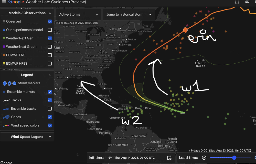
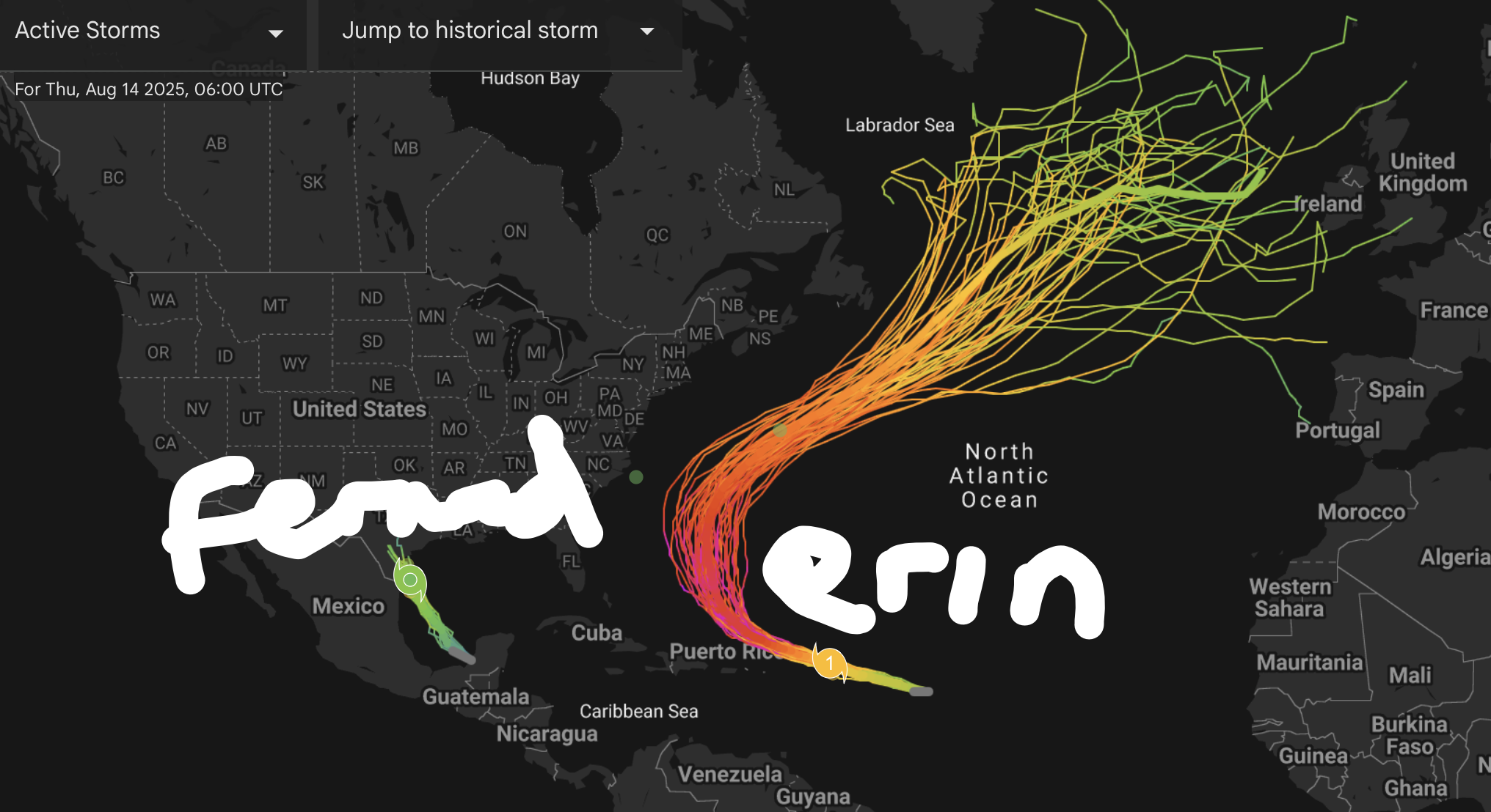
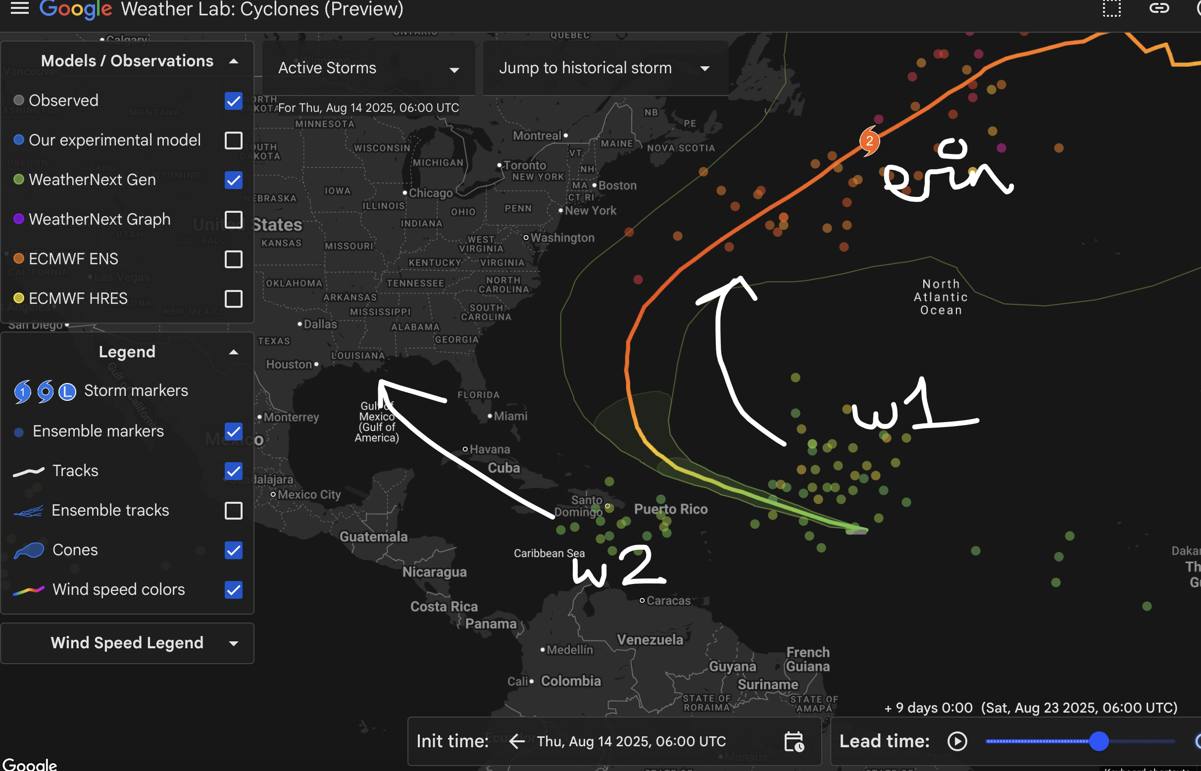
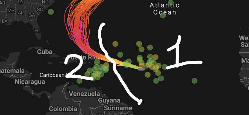
Aight never mind it’s Fernand and Gabrielle now with wave 2 coming first or what because 98L took an L I gotta Check back
-
2025 Atlantic Hurricane Season
BarryStantonGBP replied to BarryStantonGBP's topic in Tropical Headquarters
Any extrapolations? -
2025 Atlantic Hurricane Season
BarryStantonGBP replied to BarryStantonGBP's topic in Tropical Headquarters
What does the gefs say for September in terms of the mjo -
2025 Atlantic Hurricane Season
BarryStantonGBP replied to BarryStantonGBP's topic in Tropical Headquarters
Happy birthday Kat
-
2025 Atlantic Hurricane Season
BarryStantonGBP replied to BarryStantonGBP's topic in Tropical Headquarters
Won't be surprised if all these lot became bangers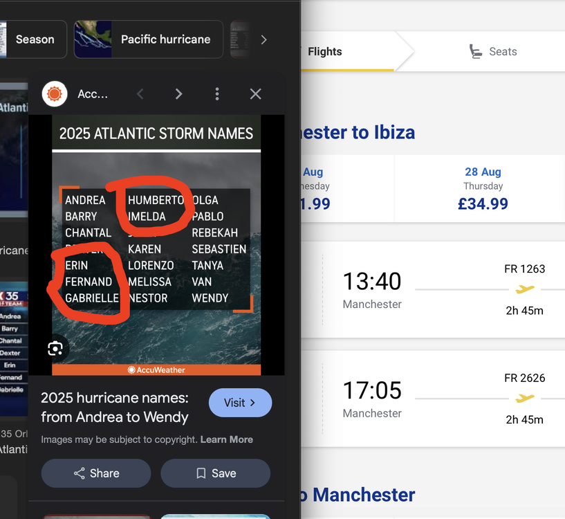
-
2025 Atlantic Hurricane Season
BarryStantonGBP replied to BarryStantonGBP's topic in Tropical Headquarters
-
2025 Atlantic Hurricane Season
BarryStantonGBP replied to BarryStantonGBP's topic in Tropical Headquarters
Oh okay lad because I remember that nonce flooded up the Tube during my son's fresher's week while blasting reggaeton -
2025 Atlantic Hurricane Season
BarryStantonGBP replied to BarryStantonGBP's topic in Tropical Headquarters
I thought humberto went to canada and bermuda -
2025 Atlantic Hurricane Season
BarryStantonGBP replied to BarryStantonGBP's topic in Tropical Headquarters
Won’t be surprised if Erin takes the role of the cleaning lady cleaning out school dinner crumbs on the table (dry air) before more kids come to play and they’d have an easier time -
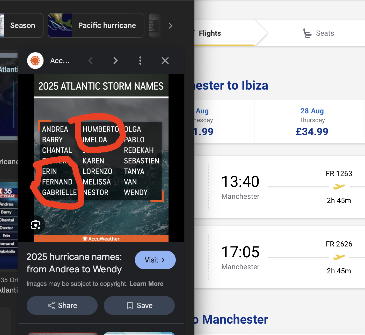
Gonna make a bold prediction the names Erin, Fernand, Humberto, Karen and Lorenzo will be 2025’s majors
-
2025 Atlantic Hurricane Season
BarryStantonGBP replied to BarryStantonGBP's topic in Tropical Headquarters
Gonna make a bold prediction the names Erin, Gabrielle, Humberto, Karen and Lorenzo will be 2025’s majors -
2025 Atlantic Hurricane Season
BarryStantonGBP replied to BarryStantonGBP's topic in Tropical Headquarters
Oi kev did ya check the ec aifs on that one lad -
2025 Atlantic Hurricane Season
BarryStantonGBP replied to BarryStantonGBP's topic in Tropical Headquarters
Were you in Georges? -
2025 Atlantic Hurricane Season
BarryStantonGBP replied to BarryStantonGBP's topic in Tropical Headquarters
MATE I SURVIVED OPHELIA AND LORENZO THEY WRECKED MY LOCAL ASDA -
2025 Atlantic Hurricane Season
BarryStantonGBP replied to BarryStantonGBP's topic in Tropical Headquarters
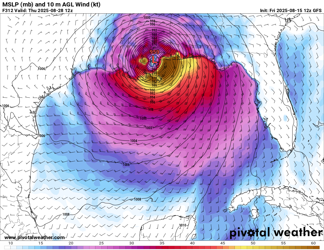
MATE DEEPMINDS HAD THIS ONE VOMITING IN THE GOA ON 29TH AUGUST -
2025 Atlantic Hurricane Season
BarryStantonGBP replied to BarryStantonGBP's topic in Tropical Headquarters
-
2025 Atlantic Hurricane Season
BarryStantonGBP replied to BarryStantonGBP's topic in Tropical Headquarters