

griteater
-
Posts
9,635 -
Joined
Content Type
Profiles
Blogs
Forums
American Weather
Media Demo
Store
Gallery
Everything posted by griteater
-
I think we'll see radar break out nicely across E TN / NE GA / NC / northern half of SC overnight into early morning and spreading east thru the day. For you and I, soundings are sketchy for snow, but the timing is good (night and early morning) and it may be just cold enough. I'd keep expectations low on amounts....seeing flakes fly and maybe some light accumulations
-
It's overnight into early morning for Western Carolinas
-
A visual of the upper low dropping down thru Nebraska and Kansas - https://www.tropicaltidbits.com/sat/satlooper.php?region=atlpac-wide&product=wv-mid
-
It’s a closed contour upper low that’s dropping down into the trough behind our departing storm. It’s currently located over S Dakota/Nebraska and will drop into E Oklahoma, then swing thru the SE states. Euro has precip breaking out with it in E TN / N GA a little before midnight then swinging east thru the Carolinas overnight and into the morning. Shouldn’t be anything major, but could be some nice embedded snow showers in there
-
Some of us have started adding some model performance thoughts on the storm here, FYI: https://www.americanwx.com/bb/topic/49398-southeast-winter-storm-threats-model-performance/?do=findComment&comment=5065039
-
The NAM is the new Dr No
-
Yeah Euro bumped north with precip and temps
-
Upper level divergence on the GFS....this is what the big ones look like
-
RAP and HRRR are usually boiling with heat...so, it's good to see though the NAM has a great track record with these winter storms over recent years....I think we all just need to move to the high country and be done with it
-
University of Wyoming has a good site for the actual balloon launch soundings (launched twice a day at 12z and 00z) - http://weather.uwyo.edu/upperair/sounding.html
-
On the topic of the upper waves. The core of our storm is the upper wave currently over W Texas. The trailing upper wave that drops down is currently over N Montana / Saskatchewan - it will drop SE into Arkansas and down thru the SE. Some earlier model runs were more impressive with it, but not as much now. Still, the 06z Euro says there could be some light snow showers with it Sunday overnight into Monday morning in E TN / N GA / W NCSC
-
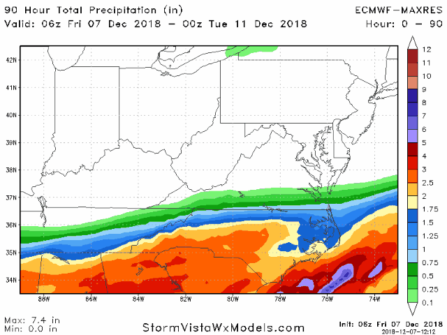
Euro Total Precip trend
-
For some reason, I don't see the 06z and 18z runs on weathermodels now...not sure what's going on there. Here's the 06z Euro run on Vista with the 850 low, then the second map is the sfc temps. It's north of an ideal track for northern upstate into CLT but it tries to bring wet snow/sleet in that area with heavy dynamics as it rolls thru.
-
I would just say that it's always a plus to see it on the cold side because if any model is going to be warm in the mid levels it's the HRRR and NAM
-
Well it's kind of impressive to see the HRRR be this cold to the south
-
Sure seems like it’s NAM and the Canadian models against UKMet / GFS / Euro regarding the southern fringe temps and the northern extent of the precip shield - 2 disparate camps
-
You sure are needy For you it jerked the 850 0 deg below you for a 6 hr period during peak storm. For CLT, it was south of us a good bit of the storm. I’m away at the moment Yes on Vista. Weathermodels has it too
-
Looks more like a cold nose than a warm one
-
Well the 18z Euro was the best run I’ve seen of it yet as well on the southern transition zone (colder)
-
Yep, impressive looking for sure. Loop - https://www.tropicaltidbits.com/sat/satlooper.php?region=atlpac-wide&product=wv-mid
-
Euro Ensemble Mean Total Precip - last 4 runs....it shows 2.0 inches liquid there from Asheville to Charlotte. I distinctly remember it showing around 1.6 inches for the Feb '14 storm as a QPF comparison.
-
I still like 3-6 inches of snow to sleet in center city Charlotte (as I mentioned late last night). If the precip wasn't going to be as heavy, I'd probably go 1-3, but I'm expecting fairly heavy precip and just enough cooling for it to pile up quick before a flip to sleet.
-
If you really want to dive in deep with the Euro on a free site, you can view temperatures at many layers at this link. It takes some getting use to, but for example, it has the vertical scroll bar on the right side here where you can essentially move up and down the column of the atmosphere and view not only 850mb temps, but 800mb temps as well. The Euro run that is out there now is the 00z from last night as it takes it a little longer to update. It says the 1z run will update around 3:30 https://www.windy.com/-Temperature-temp?850h,temp,2018-12-09-18,35.376,-80.145,8,p:off
-
Euro
-
Euro Total Precip last 4 runs


