Violentweatherfan
-
Posts
3,686 -
Joined
-
Last visited
Content Type
Profiles
Blogs
Forums
American Weather
Media Demo
Store
Gallery
Everything posted by Violentweatherfan
-

E PA/NJ/DE Winter 2024/25 Obs/Discussion
Violentweatherfan replied to JTA66's topic in Philadelphia Region
Found this YT channel from the MA forum, definitely recommend a watch -
E PA/NJ/DE Winter 2024/25 Obs/Discussion
Violentweatherfan replied to JTA66's topic in Philadelphia Region
Even the Bluebirds at my feeder are turning more blue, definitely cancel. -
E PA/NJ/DE Winter 2024/25 Obs/Discussion
Violentweatherfan replied to JTA66's topic in Philadelphia Region
All kidding aside, my feeder is packed with Bluebirds, Cardinals, Goldfinches, Titmice, Chickadees, and four species of Woodpecker. They know something is coming -
E PA/NJ/DE Winter 2024/25 Obs/Discussion
Violentweatherfan replied to JTA66's topic in Philadelphia Region
At my bird feeder the Goldfinches summer plumage is beginning to show. -
E PA/NJ/DE Winter 2024/25 Obs/Discussion
Violentweatherfan replied to JTA66's topic in Philadelphia Region
I’m gonna need a roof rake -
KC’s defense is suspect. The eagles will have to out score the chiefs to win which they can
-
E PA/NJ/DE Winter 2024/25 Obs/Discussion
Violentweatherfan replied to JTA66's topic in Philadelphia Region
I use wunderground and my reading was -4. I selected another station which allows a view of the entire county. There were other below zero stations and many above by five degrees. -
1/19/25 Eagles Playoff Winter Storm obs
Violentweatherfan replied to Ralph Wiggum's topic in Philadelphia Region
Is she sure they’re not from carpenter bees -
1/19/25 Eagles Playoff Winter Storm obs
Violentweatherfan replied to Ralph Wiggum's topic in Philadelphia Region
I had to customize that suet feeder just for the Pileated Woodpecker, double cake jawn -
1/19/25 Eagles Playoff Winter Storm obs
Violentweatherfan replied to Ralph Wiggum's topic in Philadelphia Region
Yeah, visits every day. I hear her yapping and drumming on a daily basis. I have about 30 species that visit my feeders since I moved to Jamison, Eastern Bluebirds are a special sight to see -
1/19/25 Eagles Playoff Winter Storm obs
Violentweatherfan replied to Ralph Wiggum's topic in Philadelphia Region
Looking at radar 7:30pm is the last heavy band of snow and it will taper off -
1/19/25 Eagles Playoff Winter Storm obs
Violentweatherfan replied to Ralph Wiggum's topic in Philadelphia Region
@Albedoman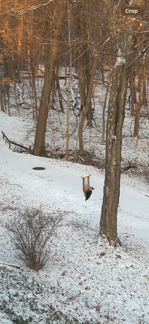
-
1/19/25 Eagles Playoff Winter Storm obs
Violentweatherfan replied to Ralph Wiggum's topic in Philadelphia Region
Ya know the grass is really greener on the other side Lol -
1/19/25 Eagles Playoff Winter Storm obs
Violentweatherfan replied to Ralph Wiggum's topic in Philadelphia Region
Definitely moderate snow now Jamison Pa -
1/19/25 Eagles Playoff Winter Storm obs
Violentweatherfan replied to Ralph Wiggum's topic in Philadelphia Region
With the cold coming in you’ll need a jackhammer if you don’t -
1/19/25 Eagles Playoff Winter Storm obs
Violentweatherfan replied to Ralph Wiggum's topic in Philadelphia Region
Cold Air Transport for the win -
1/19/25 Eagles Playoff Winter Storm obs
Violentweatherfan replied to Ralph Wiggum's topic in Philadelphia Region
Birding must be awesome there. -
1/19/25 Eagles Playoff Winter Storm obs
Violentweatherfan replied to Ralph Wiggum's topic in Philadelphia Region
@pl0k00n111! Whats up -
1/19/25 Eagles Playoff Winter Storm obs
Violentweatherfan replied to Ralph Wiggum's topic in Philadelphia Region
I don’t have a snow board, but I’d guess about 1.5 inches -
1/19/25 Eagles Playoff Winter Storm obs
Violentweatherfan replied to Ralph Wiggum's topic in Philadelphia Region
Snow returns in Jamison, steady accumulating light snow -
1/19/25 Eagles Playoff Winter Storm obs
Violentweatherfan replied to Ralph Wiggum's topic in Philadelphia Region
It’s gonna happen, it’s not the coastal development that saves us it will be the cold air crashing in. -
1/19/25 Eagles Playoff Winter Storm obs
Violentweatherfan replied to Ralph Wiggum's topic in Philadelphia Region
Flakes picking up in size and intensity, but nothing sticking yet. -
Sunday 1/19 Eagles Game Snow and Stuff
Violentweatherfan replied to Ralph Wiggum's topic in Philadelphia Region
Duration is factored in. How much snow within a period of time. -
1/19/25 Eagles Playoff Winter Storm obs
Violentweatherfan replied to Ralph Wiggum's topic in Philadelphia Region
First flakes beginning to fall in Jamison -
Sunday 1/19 Eagles Game Snow and Stuff
Violentweatherfan replied to Ralph Wiggum's topic in Philadelphia Region
In case anyone wondered