TradeWinds
-
Posts
527 -
Joined
-
Last visited
Content Type
Profiles
Blogs
Forums
American Weather
Media Demo
Store
Gallery
Posts posted by TradeWinds
-
-
1 hour ago, turtlehurricane said:
Went to Walmart and all the water is gone.
Main effect of Elsa so far in SE FL is the subsidence ahead of the storm is causing the highest temps of the summer so far. Heat index 103 F... on a normal day it starts storming before it ever gets this hot, but Elsa is stopping any storm development.
No kidding. My backyard is registering 90 with dewpoint of 78 (heat index 104) in Orlando.
-
1 hour ago, chasestormz39 said:
Vacationing in Destin/Miramar Beach. Almost all models take Elsa way East and Southeast of me but 12z NAM and NAM Nest are much further west. While seeming unlikely, anyone have any thoughts on this?
It's out of the NHC cone. I'd trust them over the NAM.
-
33 minutes ago, Double Action said:
When’s the next recon? This thing is exploding right now.
It's just an impressive tower right now tho. I read local radars are not showing any wrapping.
-
35 minutes ago, yoda said:
11pm map does not have Elsa returning to hurricane status at all
I think it's been that way since last night.
-
2 minutes ago, MattPetrulli said:
Ends with a cat 1 into Ft Myers Tuesday but I am not sure how good that's worth given its rather very quick intensification overnight tonight.
NHC talked about weakening in the next 48 hrs but potential for some strengthening after Cuba due to interaction with an ULL in the Gulf.
-
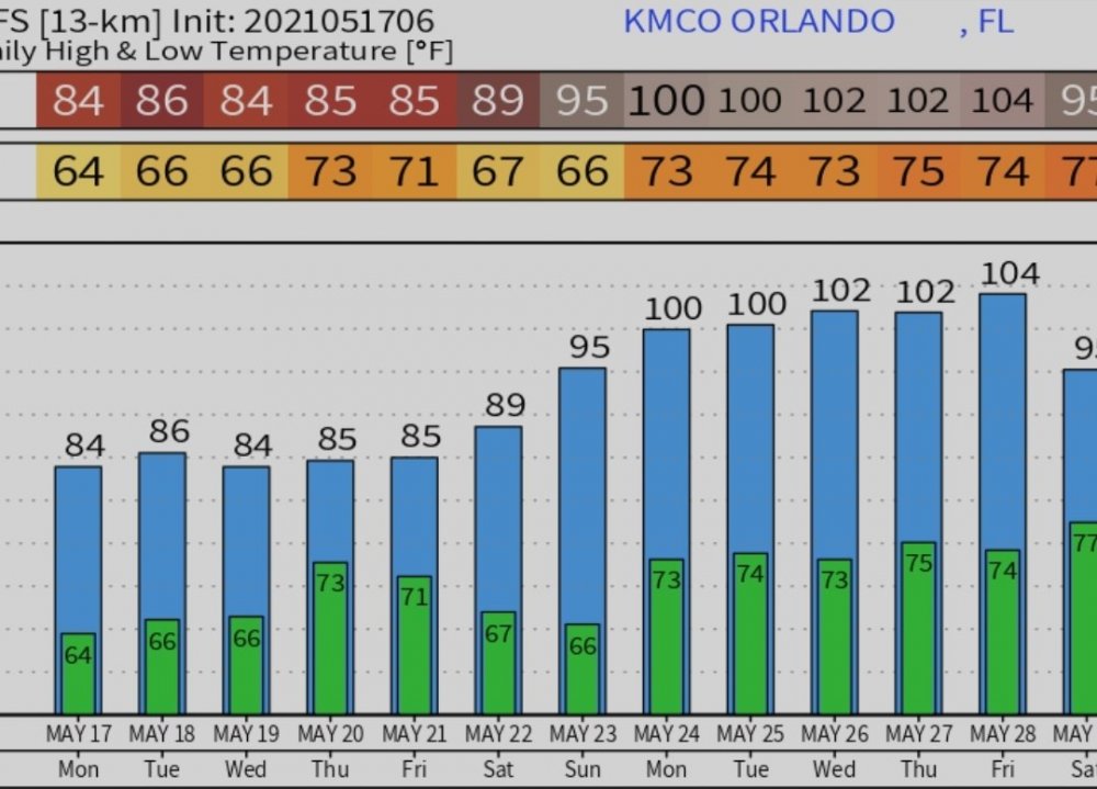
Models continue to bring record heat into FL next week. Both Euro and GFS have Orlando near 100 next week. GFS likely overdone but all time high in Orlando is 103.
-
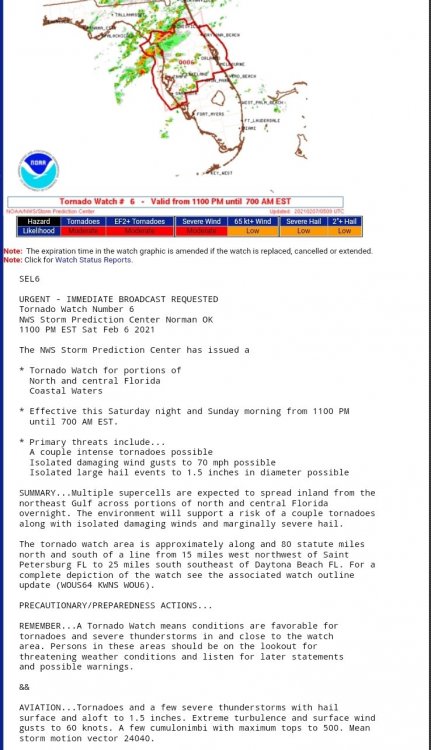
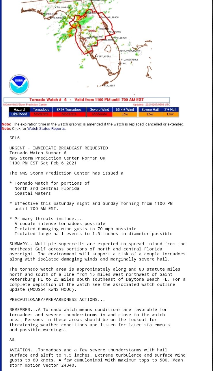
Tornado watch for Central FL extended until 7 AM. I was surprised by the moderate risk for EF2+ and words of a few intense tornadoes. Atmosphere must be ripe.
-
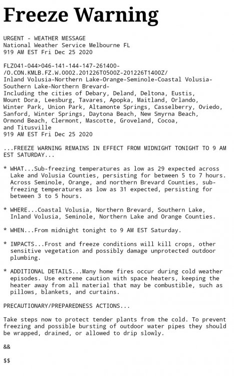
Freeze warnings being issues for Orlando area. If this is radiational cooling I like my chances as I'm on the SE of side of a large lake. I maxed at 54.1F today. I do not plan on protecting my coconut tree as it already has Christmas lights wrapped around the base. Dewpoint is currently rising. At 38F.
-
Live report from Orlando. We have a gust to 10 mph and about 0.02" of rain today.
 Sure does sound like Tampa got some big rains today. I hear some places are up to 6 or 7".
-
10 minutes ago, Windspeed said:
Yes.
Also a 67 mph gust now reported near Dundee in Polk County.Dundee is surprising. Well inland. Almost 20 miles E of Lakeland.
-
14 minutes ago, Windspeed said:
Downgraded.
Punta Gorda just had a 69 mph wind gust.
69 confirmed? Thats pretty impressive.
-
Just now, Prospero said:
PINELLAS COUNTY
In an abundance of caution, ALL Pinellas County Schools will have early dismissal today, Wednesday, Nov. 11 and will be closed tomorrow, Nov. 12. Today’s dismissal times: High Schools: 10:00 a.m. Elementary Schools: 11:00 a.m. Middle Schools: 12 noon
Not surprising. Schools close now for a light breeze. I remember in my day... lol
-
 1
1
-
-
43 minutes ago, Prospero said:
Maybe not the worst week. For November, you will enjoy a very warm week with tropical winds from the south. You may see some rain, but for the most part you will see a lot of sunshine. Orlando should be too far east to get the big rain, but the tropical breeze may be here all week.
You'll see clouds moving quickly over and get to experience a "tropical" system. Even if Eta becomes a hurricane, it will not be a Charlie that races across the state impacting Orlando.
Enjoy your visit! You may have picked the BEST week to visit central Florida.
")
Tampa Bay, maybe not as much. LOL
Not sure I understand the rain comment. The winds are onshore from the Atlantic early this week. Local weather says 2-4"

-
59 minutes ago, hawkeye_wx said:
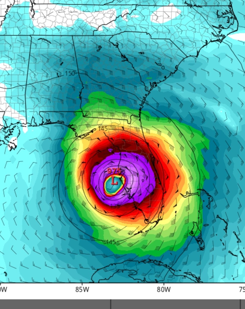
Eta's future continues to get more interesting. As the NHC says, models are going farther southwest after passing by Florida. The new GFS has this thing strengthening to 959 mb in the southeastern gulf.
It's 2020. Why not a mid-Nov cane moving SW in the Gulf.

-
 1
1
-
-
3 hours ago, Prospero said:
miserable hot and muggy in Florida.
No kidding. The heat is relentless this year. Next week looks to break the humidity which will be nice for me to go running outside.
-
@Prospero for you to frame.

-
1
-
-
1 hour ago, Prospero said:
"Watch Gulf of Mexico hurricanes safely from your beachfront balconies in luxury vacation condos from Clearwater Beach to Sanibel Island!"
Not far from the truth this year...
")
Lol. Yet my home insurance will somehow go up in FL next year.

Quite interesting to see a storm projected to move northwest this time of year in the Gulf.
-
46 minutes ago, CTWeatherFreak said:
Central Gulf yet again?? I left noreaster territory in the hopes of nabbing a cane or two. This is definitely not my year.
Central and Southern Florida new tourism ads should say tired of hurricanes...visit us!

-
1
-
-
On 10/21/2020 at 9:27 PM, cptcatz said:
The GFS had not been doing the fantasy storm thing at all this season up until last week. In fact, it was having a really hard time picking up any storms in the long range that actually ended up forming. I wouldn't count out the first week of November yet.
I thought I remember lots of fantasy storms early this season. Maybe I'm confusing with last year.
-
6 minutes ago, cptcatz said:
I know the GFS just punked us with the storm that should have been forming right now in the Caribbean, but it's also pointing to another strong possibility the first week of November. One last trick up its sleeve?
It always has a storm > 300 hrs. I had patio work done in Aug and kept a lot of things inside. I'm putting them all back outside this weekend. Door is shut IMHO for CONUS landfall. I believe I read 5 landfalls in Nov since 1850.
-
8 minutes ago, Modfan2 said:
And we don’t need any more rain here in the Jupiter area
Been wet recently or for the summer? It's been very dry the last couple weeks in Orlando.
-
1
-
-
3 minutes ago, cptcatz said:
18z GFS is drunk, go home.
ha, it's doing a 06z Para only that one straight to TX. 00z should correct like Para did although I have seen a few more members hint at a turn west. So far out and so many factors.
-
1
-
-
18z GFS has Caribbean storm landfalling at Jupiter, FL moving just inland of Vero, stalling then moving SW into Gulf. Change looks due to 2 things: 1) Atlantic storm weak and east. 2) Trough in the plains is not as sharp so storm coming out of Gulf doesn't get pushed out. Flip Flop continues. Will be curious to see the ensembles. Several were showing west movement at 12z and I believe one EPS...will need to see if this is a trend.
-
11 minutes ago, MJO812 said:
That's not OTS
I was referring to EPS.

-
1
-


Hurricane Elsa
in Tropical Headquarters
Posted
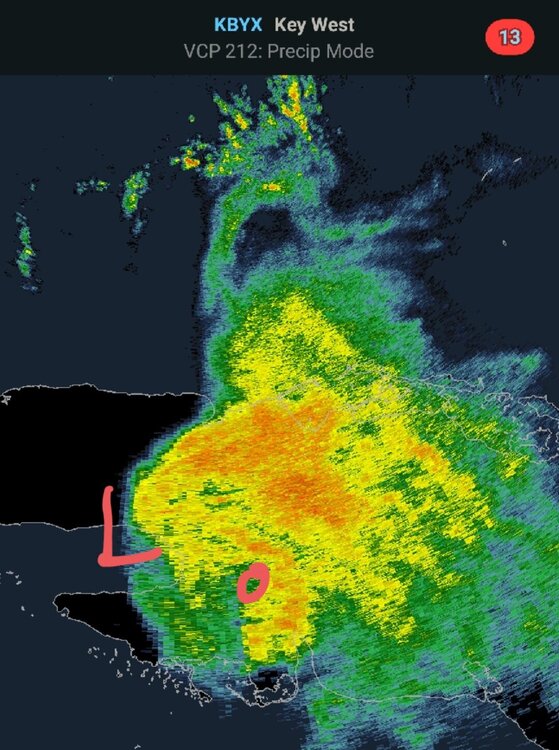
You can see some rotation on the Key West radar. Maybe mid level circ? I guess the LLC is at the point of the yellow.