

TradeWinds
-
Posts
527 -
Joined
-
Last visited
Content Type
Profiles
Blogs
Forums
American Weather
Media Demo
Store
Gallery
Posts posted by TradeWinds
-
-
4 minutes ago, Prospero said:
Thanks TradeWinds, Florida neighbor.
I've been involved in internet forums since the 90's, alt this and alt that. I've been checked so many times I can't count. But manners are important, and timing is everything. When the discussions are barely active there is room for more personal input, like where to go for Sushi, etc., or occasional far-out ideas. But I do get excited when things are active and have posted inappropriately after a few beers when people are scrambling for their lives as a hurricane is approaching. I am not trying to be on ignore lists, and it hurts my "feeling" (as a good friend used to joke with me), but learning the expectations of any social environment is just part of growing up and belonging to a group. If I am ignored, it is my own fault. Someone making a point of it publicly may or may not be seeking attention, it may be directed totally at me to "behave" which I get. My skin is thick, by experience! When I get to the point of not learning or taking criticism, then I am trouble.
Second part, in Tampa Bay we've been in so many models with powerful storms predicted several days out that we are getting numb. That is foolish, as this is 2020 and only mid-October. We do know we may be preparing for a storm even up to Thanksgiving. But it is weird we have not been in an actual Tropical Storm or Hurricane warning this year. That might even make it more likely we could get slammed at the last minute to fully complete 2020. (Ooooops crazy talk again!)
")
There will be so many flip flops from Yucatan hits to out to sea to nothing at all, which very well may be the end result. But we watch. The FL peninsula as a whole has been spared. We had an inland tropical storm warning in Orlando with Isais but our highest gust may have been 25 mph.

-
3 hours ago, Prospero said:
Still hoping west central Florida skips the storms, but it does seem unfair we have not been in any kind of warning in 2020 and that is just embarrassing.
For those who have not added me to their ignore list, Tampa Bay is more in the focus on the 12Z model:
Who cares what people think. I have no respect for anybody seeking attention by having to announce their intention to block somebody. I have seen plenty of ridiculous posts all over this forum, especially when I lived up north and winter season came along. The majority of this site lives of fantasy storms.
Back to your post...look at the bright side, you had lots of flood watches this year. lol. I had some patio repair work back in August and had to clear off my lanai. I kept things inside for hurricane season and almost put them back this past weekend. I figured I'd wait another couple weeks just in case. We should know more by early next week.
-
 1
1
-
-
3 hours ago, Prospero said:
A Wilma that wind shear takes down to a TS a few hours before landfall works for me. We've dodged a few this year, and have barely done any prep, but could handle the thrill (and fear) as long as we don't lose power or any more trees. Irma took all of our morning to noon shade Oaks and our electric bill went way up keeping out house cool in the summer since.
I'd even be open to a decent 6-8 ft storm surge and our humble town of Gulfport, Florida would recover and everyone would pitch in to help out the businesses downtown. (They may not agree so much though...) I suppose a 6-8 ft storm surge here might be closer to 12 ft or more in downtown Tampa where the Tampa Bay might be pushed up, so that would not be good news for Tampa.
I'd rather no more storms for Texas, Louisiana, Mississippi, Alabama, or the Florida panhandle this year. They got their share already.
Of course I'd rather a weak storm hit here on the weekend when I am not working as much so I can enjoy it more.
So far I give the season an A-. It started early, kept busy, a lot of hours watching and reading here and there, and I really haven't been bored til now. But with the absolutely gorgeous weather the past couple days here on the central west coast of Florida, no complaints at all.
It really has been an odd but solid year for tracking. I hate so many were impacted though. We will see how October materializes and whether the FL peninsula can keep the force field going. It's the only place that hasn't really been impacted. Isaias had warnings but very minimal impact to FL.

-
2
-
-
3 hours ago, bigtenfan said:
Agree about MDR season possibly being about over( although one never knows) but out of curiosity with W Carib season about to start what makes you say that that the Gulf may be done for the year? I think that the gulf is very vulnerable during W Carib season.
Western Gulf. Climo typically closes the valve on TX and most of LA as the fall weather pattern sweeps in cold fronts. TX has had 2 post September hurricanes in 120 yrs I believe. Most common threats are New Orleans to Florida.
-
7 minutes ago, Prospero said:
Any bets this is a TD by sometime tomorrow? Long term it will probably not develop much, maybe not a name. But around here we are never surprised to wake up and check the news to see a TD developed overnight when we were asleep.
Watching the palms sway, oaks dance, feeling a very stiff steady warm breeze, it feels like "something", again.
Then I watched a large swallowtail butterfly that was in the wind effortlessly fly from one hibiscus flower to the next as they were moving to and fro. It must weigh less than a typical bird feather, and had the DNA programming to adjust its wings and work with the wind, not against. Incredible.
The 850 voricity is strong. I can see an invest but not a storm. It is 2020 though so you never know. We had some good squalls come thru earlier. I have some video but too large to post.
-
1
-
-
Land cane


-
3
-
-
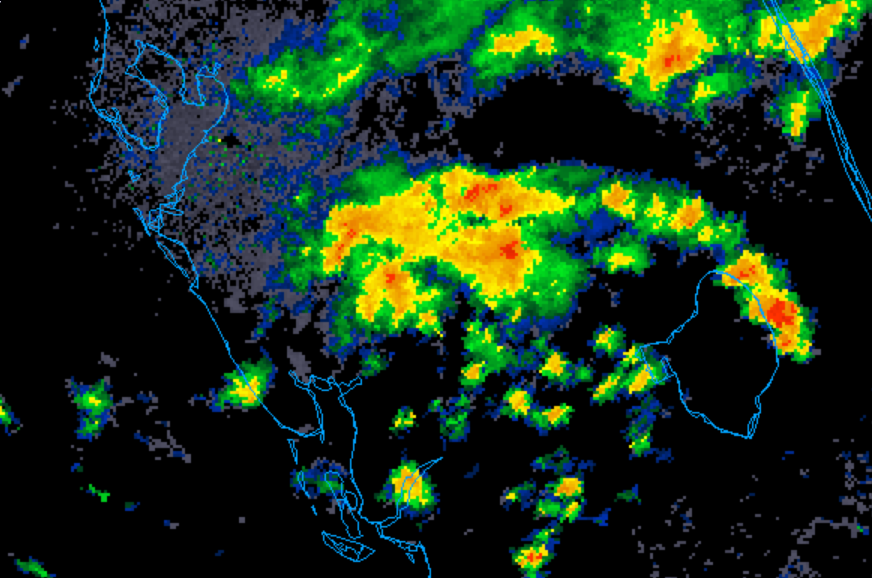
That little yellow X off FL giving us some squalls today. NWS Melbourne has a special statement for coastal areas of Central FL last night. 4-8" of rain and 35-40 mph gusts. Several buoys had confirmed 40. That was a surprise.
-
2
-
-
3 hours ago, WxWatcher007 said:
CAG signal would fit the climo. Starting to see some signals on the guidance. Congrats Miami?
First call..Louisiana.

-
1
-
 1
1
-
-
3 hours ago, the ghost of leroy said:
As usual, there is a stupid amount of heat content in the western Caribbean. FL is due for a repeat of King or a cleaner Wilma.
Well 00z fantasy land has the Western Caribbean storm

-
1
-
-
7 hours ago, turtlehurricane said:
West Caribbean will be crazy going into October. Florida will be lucky to not see some serious threats with the way this season is going.
We have the force field going on for most of the peninsula sans Irma
 I am curious what Oct brings. GFS long range hints at lowering pressures but it's always there on the 384.
-
1
-
-
5 minutes ago, Maestrobjwa said:
Which one is that, and why the "hmm"? Lol

-
 2
2
-
-
33 minutes ago, OSUmetstud said:
UKMET was the best with Laura. I posted the Albany stats in that thread. GFS outperformed ECMWF for Laura, not sure if that's true for the season as a whole though.
That must have been it! Thanks for the clarification.
-
3 hours ago, OSUmetstud said:
Can you post a link? I know it's been struggling with TCG but I would find it a bit hard to believe the routinely best track model is now the worst this season.
I'll have to do a search and find it. It was in one of these threads. I believe the Laura thread or this one. UKMET was leading if I remember. One reason models might be off this year is due to less input resulting from covid.
-
20 minutes ago, MJO812 said:
how did the euro do with the past storms ?
Read an article recently that compared models for the 2020 Atlantic hurricane season. Euro was the worst in all lead time categories even less than 72 hrs. Not saying it will not verify but the track record is off this year so far.
-
1
-
1
-
-
7 minutes ago, cptcatz said:
Where are you seeing this? The GFS is loading super slow for me.

-
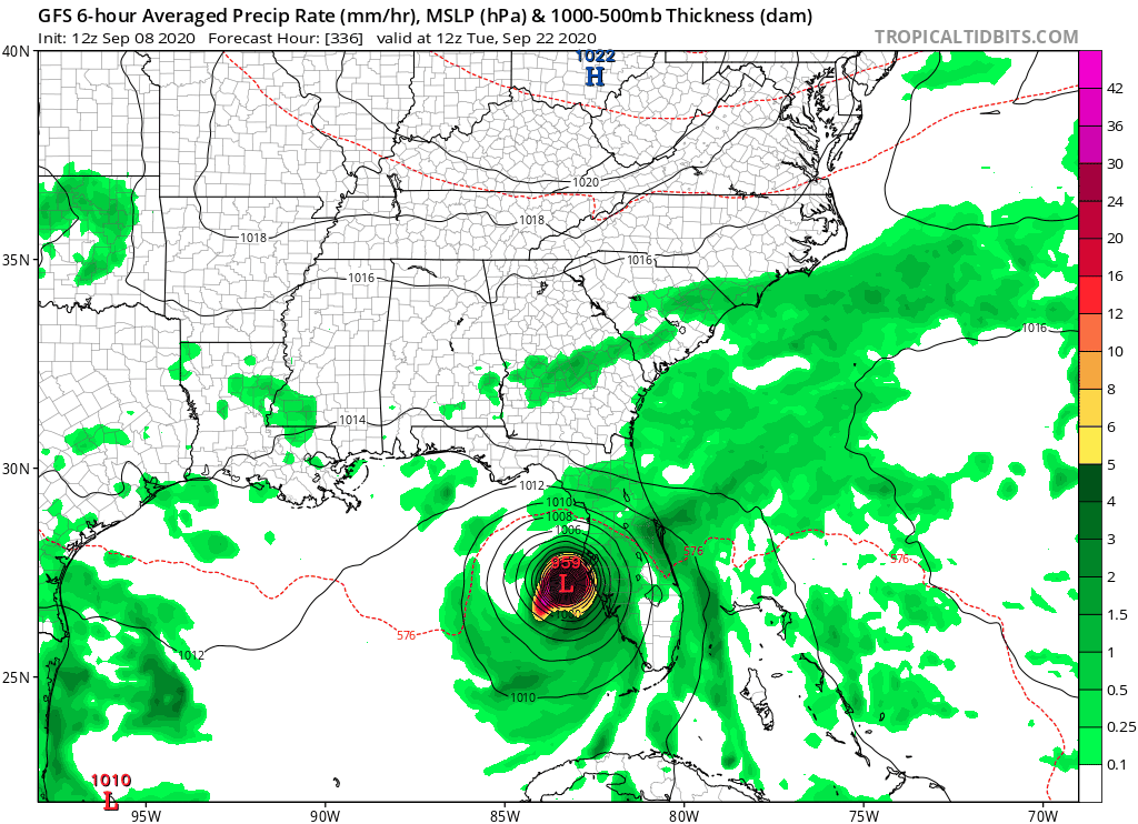
2 hours ago, Windspeed said:2 hours ago, cptcatz said:12z GFS with the dirty side of 959 mb Sally going into Tampa Bay...

If that run were to verify, the hypothetical Caribbean/EGOM system would've been Teddy. The GFS does a weird monsoonal split and breaks off the upper axis first that becomes Sally. It then allows the southwestern extension to close off into Teddy and it gets captured by strong ridging / easterly flow. Sally merges with CATL troughing. Teddy drives into the CONUS. Meh...looks gimmicky and likely to not model that way in future op runs with any consistency.
A few EPS members have the exact same scenario although it evolves differently up front. I agree though the ops will change a lot.
-
38 minutes ago, thunderbolt said:
The way I look at it is Naples is South Florida Tampa Bay Central Florida Tallahassee is North Florida at least according to Latitude
Everybody who lives here knows Tampa is Central Florida. Your post is correct.
-
2
-
1
-
-
22 minutes ago, Jackstraw said:
Just my armchair opinion as we move into the peak over the next week but I've said it before this season. The pattern over the Conus since about mid July has been anything but normal. Up here in the lower great lakes where I am we've had 4 nights below 50 and a string of sub 80 degree days in August, that's kinda nuts. The trough anomalies - placement, strength and depth have been consistent for the last 6 weeks, consistently from the upper midwest down through TX. We're moving into a similar pattern again over the next 10 days. We do have a bit of weaker ridging over the Atlantic currently but there's signals in the ensembles for that to be temporary and begin to build a stronger WAR by the end of the week. Anything that develops off of Africa quickly will more than likely be shark food. But weaker waves that would be less likely to feel any weakness in the ridging prior to 50W could very well roll into a favorable environment and steering to threaten the states I especially think the GOM is far from done if this Conus pattern persists and we possibly could see an abnormal increase in the number of GOM storms by seasons end. As WxWatcher007 has pointed out the tepid west pacific season just hasn't been energizing the northern jet and this has enabled the pattern over the Conus to be rather stale, allowing some rather stout stubborn ridging in the SW and deeper slow moving troughing over the central US. If we don't get some west pac energy rounding into the northern jet over the conus we could still get into these slow pattern locks like we've seen.
Just based on that rather weak analysis lol, to me, I think the chances of any storms that either make it to or begin organizing past 50 or 60W and south of 20N the possibility of any affecting the states is higher than normal unless we see a substantial pattern change over the Conus. Where the troughing is currently settling it's going to be able to draw anything north into the GOM or pull something into the EC. It would be nice if the troughs were digging 3 or 4 hundred miles farther E providing a shield for the EC and driving southern storms west. West coast of Fl.'s season is coming up in a few weeks, end of Sept. into Oct. If the pattern shift waits until then it could get interesting. I'm not a landfall wisher by any means, just my uneducated guess moving forward.
And one more thing, where the hell are the TUTT's this year? Anyway sorry for the long post, takes me a while to form an armchair opinion nowadays
It appears a CCKW will pass 3rd week Sep thru early Oct. The Gulf and western Caribbean could spark but no guarantee. Anybody know if those are factored into models?
-
15 hours ago, Prospero said:
A question that is important for GOM coast communities; is there much as far as future models for storms that pop up and become powerful storms that are not waves from Africa?
I know here in the Tampa Bay area, we've woken up to TDs that formed overnight just off the coast with a big surprise to many of us.
Waves off of Africa are tracked for a long time, but GOM storms are short notice. Right?
Depends. Sometimes models can sniff out general disturbances or lower pressures in a region of the western Caribbean/Gulf. I've also seen invests pop up on the tail of a cold front. I'm not sure if models consider CCKW into their forecasts but I'd be surprised if we do not see an uptick in activity in this area 3rd week of Sept to mid Oct when a CCKW passes.
-
1
-
-
26 minutes ago, yoda said:
I think he meant the website weathermodels... not the actual ones... at least I thought that
@TradeWinds is that what you meant? Or were you trolling about the actual weather models themselves?
WTH is wrong with everyone? I just asked where the Para ensembles is for heaven's sake.
-
4 hours ago, NJwx85 said:
12Z PARA GEFS still really likes the idea of a system on either side of Florida around mid month.

Where is this on weather models?
-
1 hour ago, Windspeed said:2 hours ago, cptcatz said:Laura really makes a great case showing why we can't trust the models 5+ days out. These were the GFS and Euro runs from this past Friday, exactly 5 days ago, valid today:


If ever there was a case in point, this is it. 5+ days out you might peek at the operationals for patterns, precip, derived winds, feature locations, and especially entertainment purposes, but for estimates on TCs and their storm relative potential, you go with the different ensemble packages all night and day long. I don't mind beating that dead horse into a smear until frequent posters get it.
Agreed. I'm curious of low pressure placement and pressure on ops but I quickly jump to all the potential patterns.
-
56 minutes ago, CheeselandSkies said:
Not with the ridging that's being modeled.
I was looking at the way it rams into a mega ridge and thought....how? lol. Also do not buy the rapid development. That Atlantic looks dry like it has all summer.
-
 2
2
-
-
Those 500mb heights first week of September sure look to signal a potential EC threat if something forms.


2020 Atlantic Hurricane Season
in Tropical Headquarters
Posted
The flip flop continues for the potential storm end of Oct. EPS pretty much all out to sea.