

TradeWinds
-
Posts
527 -
Joined
-
Last visited
Content Type
Profiles
Blogs
Forums
American Weather
Media Demo
Store
Gallery
Posts posted by TradeWinds
-
-
16 minutes ago, Hoosier said:
It'll be a candidate with the rain and wind. They had the 90-100+ mph gusts in Charley, but Ian looks to produce a helluva lot more rain.
My official Hurricane Statement has increased every update since yesterday. Now says peak wind 55-70 with gusts 100. I'm near MCO.
-
7 minutes ago, HIPPYVALLEY said:
I’m just catching up, so sorry if it’s been covered but how far inland are hurricane gusts expected? All the way to Orlando?
I'm near MCO. Local news said center to come through around Kissimmee/St. Cloud. Called for possible sustained 50-70 with gusts to 90-95.
-
 1
1
-
-
9 minutes ago, GaWx said:
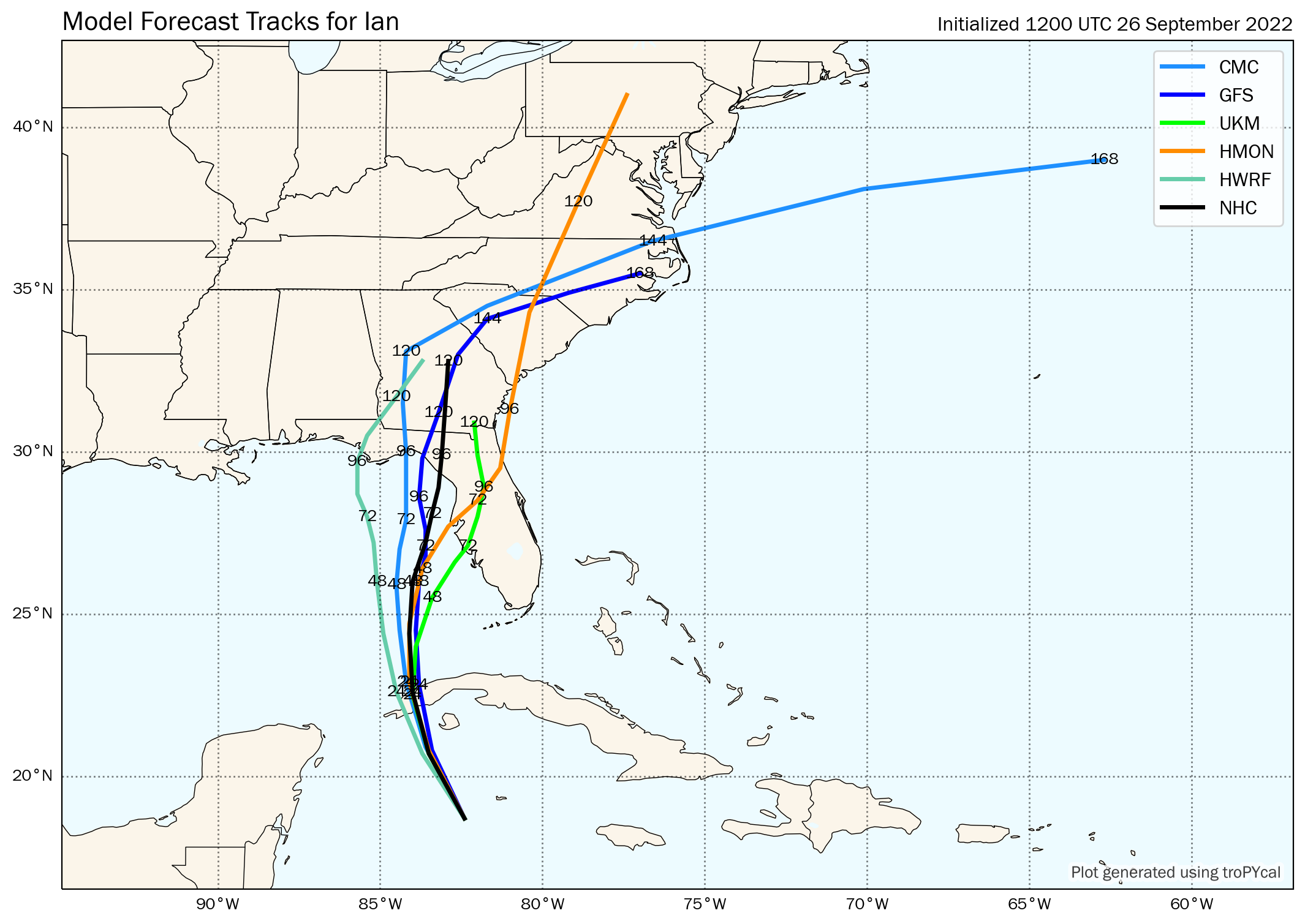
Ian moved from 24.6 N, 82.9 W at 10 PM to 26.1 N, 82.7 W at 9 AM. So, this was a move of only 0.2 east vs 1.5 north the last 11 hours. This equates to an average direction of movement of only 7 degrees vs the 15 degrees that the NHC has been saying. Compared to the 11 PM NHC forecast, it is now 15 miles due west of that projected track point. That may not seem like much, but that makes a significant difference regarding landfall point due to the angle of the FL west coast relative to the direction of movement.
Every deviation also changes who gets the excessive rainfall.
-
 1
1
-
-
7 minutes ago, GaWx said:
Ian appears to have been moving steadily N instead of NNE recently. If so, was this expected?
Maybe just wobbles? As a personal side, N is better for me as I'm on the southern edge of the 15+ rain forecasts.
-
1
-
-
3 minutes ago, WxWatcher007 said:
If a South of Tampa landfall occurs, I hope several here learn that models can sniff out changes. Too many posted here to throw them out...it's too south.
-
4
-
-
1 minute ago, Clyde said:
Really tough to compare this to Charley IMO. Charley was a rapidly intensifying micro cane with a very small diameter of greatest winds. I went through the ‘core’ in East Orlando and saw pretty significant damage from a storm that had been over land for 12+ hours, but my family on the other side of I-4 (about 20 miles away) only saw 25-30mph winds.
I think Ian is going to be larger with more impact over a broader area, although maybe not as intense as Charley.
.Agree. Very small and very fast. Charley still produced Orlando's largest wind ever recorded. 106 mph. Shows how fast the storm moved from S. Florida.
-
2
-
-
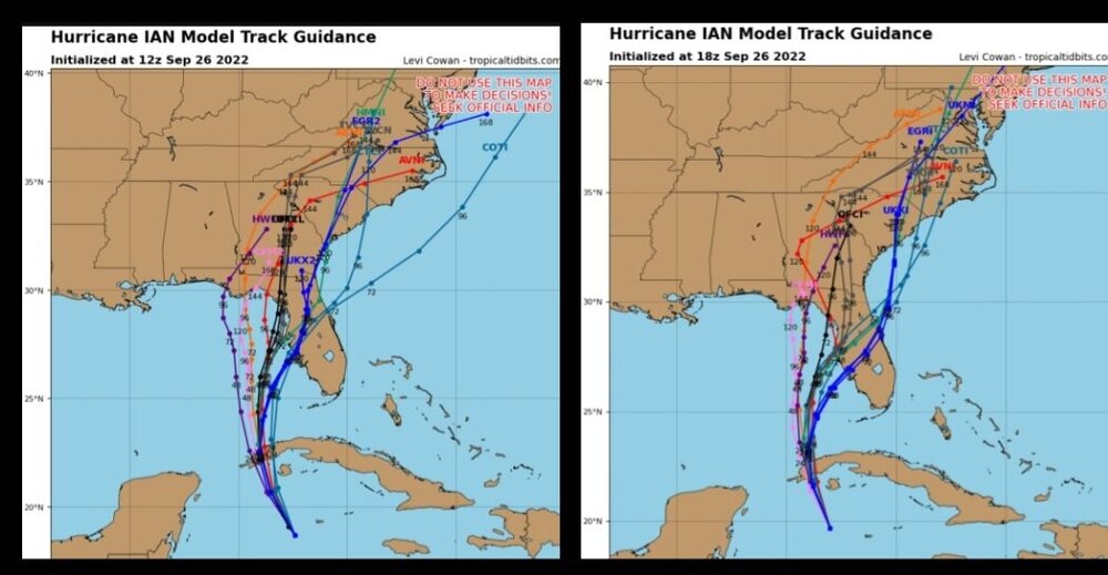
Very similar agreement on track between GFS and Euro. Euro is 24 hrs to get from landfall to Orlando. Wow. Drops a few lollipops of 30" Temple Terrace to Zephyrhills. Would be surprised if NHC doesn't adjust to at least I-4 corridor track next update.
-
10 minutes ago, hawkeye_wx said:
The current recon plant's final pass found 961 mb.
There has been a bit of a bend to the nw while this plane has been out there. Every bit of movement to the west of north matters for the long-term track. The 18z Euro moved into Cuba due north of where the center is now.

On radar, it may have wobbled but looks minimal. Also looks to have wobbled back on the NHC track. But agree on longer term path.
-
-
GFS landfall Siesta Key. Will be curious to see the ensembles. If they trend east, I would think NHC 5 AM track might be quite different.
-
All Rosen properties in Orlando are $70/night through the weekend to help evacuees. Pets welcome. Very cool.
-
1
-
-
-
3 minutes ago, WxSynopsisDavid said:
The issue here is that coastline has tripled in population from 2004 and its way more populous now. There's no easy way about it, all these scenarios we are looking at are equally devastating. The original west track taking Ian north into the panhandle being ripped to shreds by shear/dry air before landfall might of been the best case scenario presented to us yet.
This is why those in the cone should always prepare. It may still go N to the Big Bend. They should be equally prepared.
-
4
-
4
-
-
I posted earlier about this. Several models were starting to see an escape. Local met even seemed surprised his model went east this evening. Maybe a useless model but more and more concern several are showing this. Also watching trends on radar. Last update shows storm moved almost due N from 5 to 8 update. If it passes just to the left of the island S of Cuba, then Ian is officially riding the right edge of the cone.
-
4 minutes ago, Ed, snow and hurricane fan said:
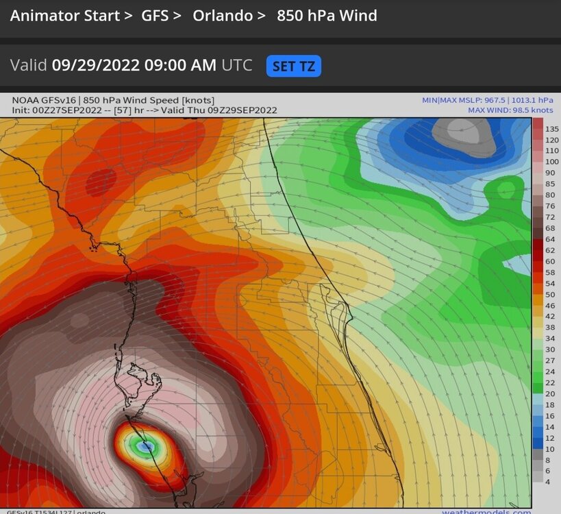
WeatherNerds is overloaded. Can anyone post 850 or 925 winds from GFS? Even with frictional slowing of surface winds, if there are storms, those storms should mix down inland. At 66 hours the dry air hasn't reached the TPA area.
I'm only to hr 57 on weathermodels. Sarasota is about 100-110 kts. Tampa about 70 kts. That's 850.
-
1
-
-
GFS takes an odd jump almost NW between hr 30 and 36. Not sure what that's about.
-
4 minutes ago, CamSE-Wx said:
Is it just me or does it look like it's moving west on the GOES?
I'm watching radar and it still looks NNW to me.
-
1
-
-
Sounds like NHC projecting landfall about Crystal River/Cedar Key based on 5 PM discussion.
-
-
18z guidance has more members leaning towards an escape to the Atlantic or at least a path inland. It's all gonna come down to the timing of the trough vs High pressure building in.
-
3
-
1
-
-
5 minutes ago, StantonParkHoya said:
It’s also literally the only model with such an absurd track
HMON is similar. It caved today after showing panhandle hit after hit. I'm not saying it's correct either but just because they feel the effects of the trough and touch the Atlantic don't make them absurd.
-
1
-
-
Looking back on the last 3 NHC wind and position estimate forecasts, track looks decent. A hair to the right of track. But noticeably weaker. 11 PM had the slower development. 5 AM was aggressive with winds ramping up all day and now they scaled back some at 11 AM (but a sharp spike up to 140 briefly). Perhaps the early AM models were a tad too strong with this system early causing the west track. We'll see.
-
1 minute ago, WxWatcher007 said:
With all the grief it gets, the GFS has done fairly well given the track chaos thus far.
Probably why the NHC kept track closer to GFS mean than Euro at times.
-
25 minutes ago, Eskimo Joe said:
HMON looks like it is doing as well as GFS and better at 72 hrs. Interesting that the tracks for several days were consistent with GFS to panhandle/big bend and jumped way south at 6z (TPA to Jax).


TD 9/Ian Banter
in Tropical Headquarters
Posted
Squalls really picking up in Orlando