

TradeWinds
-
Posts
527 -
Joined
-
Last visited
Content Type
Profiles
Blogs
Forums
American Weather
Media Demo
Store
Gallery
Posts posted by TradeWinds
-
-
2 minutes ago, StantonParkHoya said:
It also sent more members to New Orleans
Anything is possible but the flip flopping is proof this model is lost.
-
32 minutes ago, StantonParkHoya said:
The mean is literally in the exact same position. Maybe 10 miles east.
It does have a lot more members TPA south and reintroduced Ft Myers. But it also added California evidently.
-
 1
1
-
-
6 minutes ago, StantonParkHoya said:
Euro about 50 miles west, pretty similar to GFS.
We may finally be getting a good idea on Florida target.
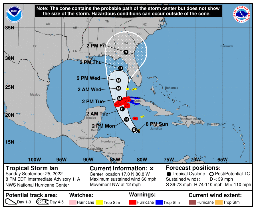
Maybe. Depends on what was initialized. NHC position went almost NNW from 2 PM to 8 PM. Not sure the big jump N was forecasted.
2 PM: 15.7N, 80.0W
8 PM: 17.0N, 80.8W
-
1 minute ago, Hotair said:
They still plan for the due west jump. 8 PM now says moving NW. That wasn't planned until tonight but it's been all day.
-
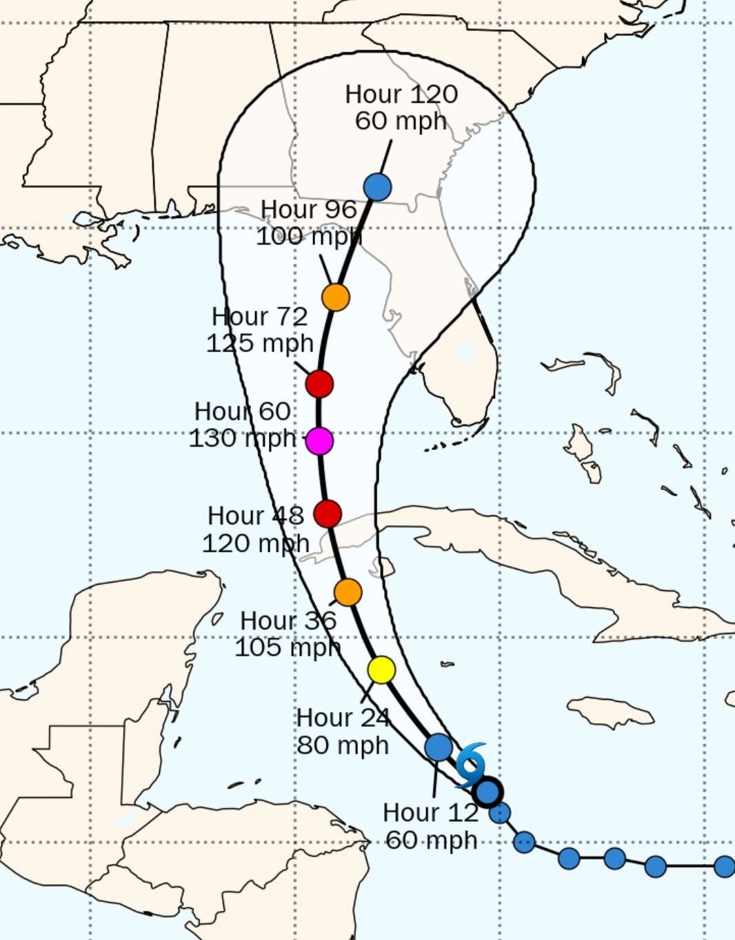
NHC and some models hint at a west jog sometime overnight. For now, the storm keeps riding the right side of their cone. Will be curious to see if it wobbles west at some point.

-
3 minutes ago, WxSynopsisDavid said:
Exactly, which draws into perspective that Ian is deepening at a much faster rate than what was originally forecasted and shown by the models. This is going to be huge/detrimental to the forecast track so I expect further adjustments on the models tonight.
The current location is exactly where the Euro had it dropping below 1000 mb for the first time across several ensemble members. Not sure why that would deviate current forecasts.

-
 1
1
-
-
I'd call this a significant change in 24 hrs.
-
1
-
-
GFS crosses Cuba on 18z where Euro has been for the last 2 days. Maybe even more east over Cuba.
-
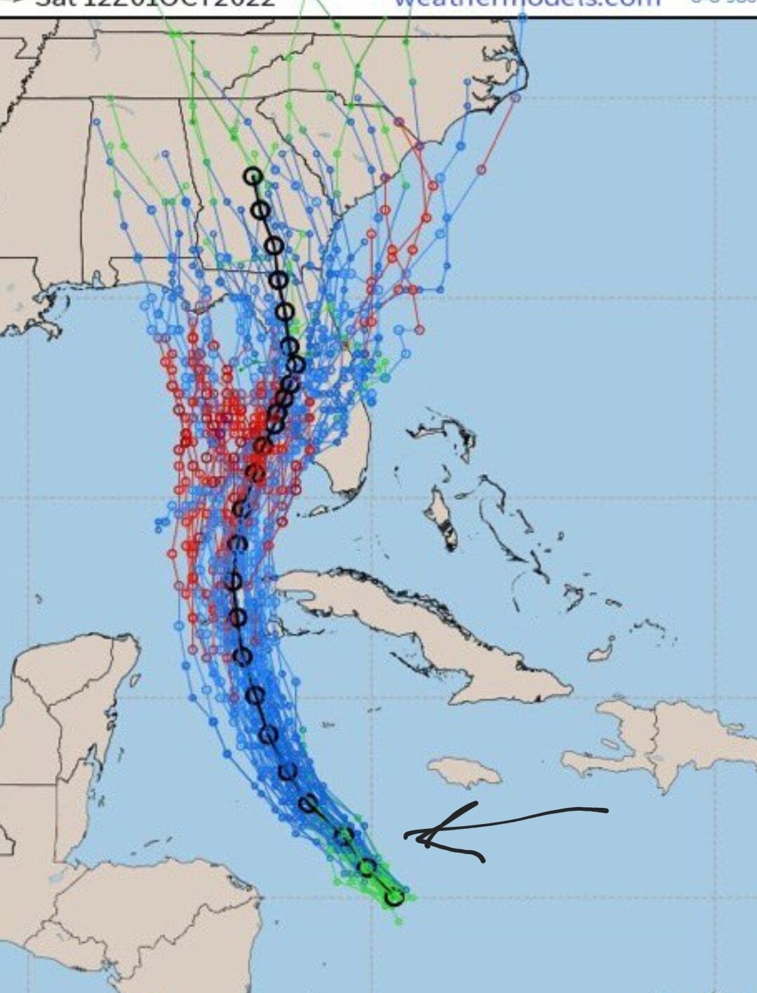
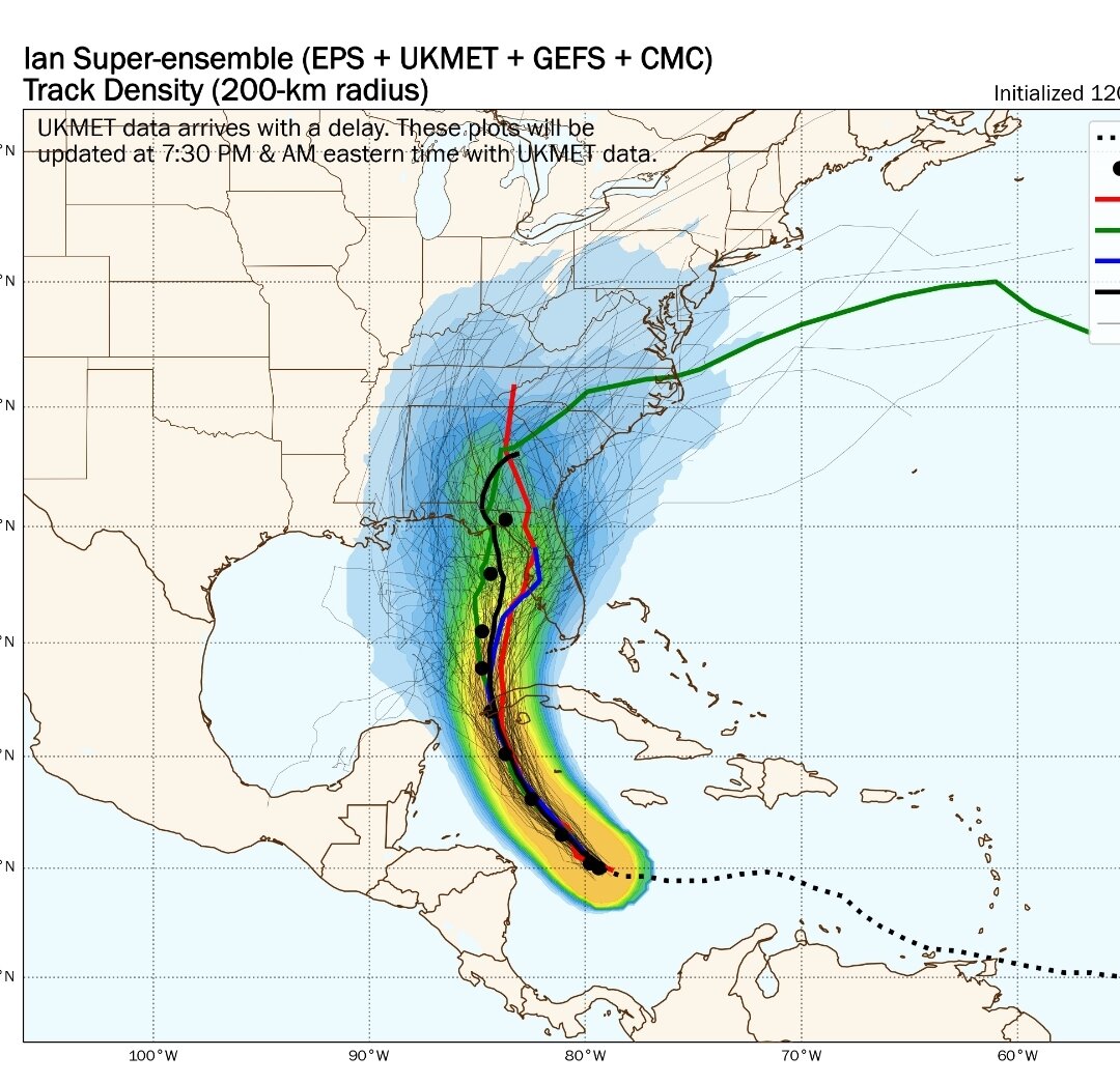
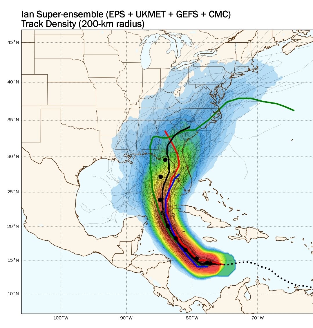
Density ensembles show more error east possible than west. Appears current position riding right side of cone. Would think NHC may tweak right a hair if any changes at all.

-
5 minutes ago, Kevin Reilly said:
Probably shear WSW and dry air intruding SE
yes. At landfall, 700 hPa layers has 50-60% relative humidity wrapping well into Central FL.
-
Those dewpoints are unseasonably cold this week in Northern FL. As storm passes Tampa on GFS, Tallahassee dewpoint is 40F. Euro in the 30s. Wow.
-
2
-
-
4 minutes ago, cptcatz said:
Not sure if I'm being a weenie but it kind of looks like the low level swirl is moving due north on visible. A little hard to tell through the taller clouds but that's what my eyes see.
It's always deceiving. GFS yesterday had it crossing 15N and 80W. So GFS was definitely too far south.
-
6 minutes ago, olafminesaw said:
Looks like a big 'ol plate of scrambled eggs. Like something straight out of the WPAC. Maybe Dmin tonight can get some convection going and get this thing going
Basically going according to plan
-
The wipers are on high on this vehicle. Still time to go more east or back west.
-
GFS position later this afternoon is still S of the current position. I'd be surprised if the GFS doesn't have further corrections in later runs.
-
2
-
-
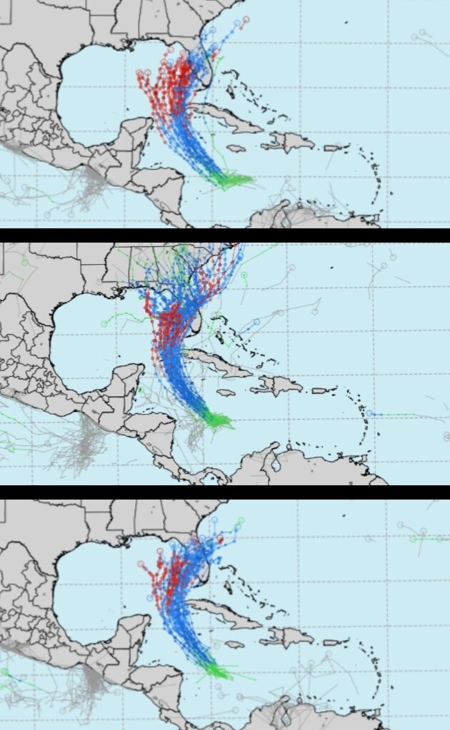
ECMWF ensembles 18z, 00z, 6z. Clusters tightening and noticeably weaker in the Gulf.

-
1
-
-
7 minutes ago, GaWx said:
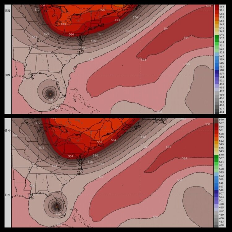
12Z ICON: goes to Jacksonville, which is 100+ miles east of the 6Z and 0Z runs.
Big difference in ICON 12z yesterday (top) vs 12z today (bottom) is a faster Ian and a slightly sharper trough. Wonder if new data ingested yesterday caused the shift to the east. Will be curious what other 12z models show.
-
24 minutes ago, StantonParkHoya said:
Sure feels like some people wishcasting an east trend just to see mayhem for Tampa…
People are just following real time obs and trends. It's called weather forecasting. And the cluster has moved east, probably because models are trending faster. Might not pan out but something to watch.

-
4 minutes ago, Weather Mike said:
Euro, ICON and UKMET has been steadfast against the GFS and all the others that head it up the panhandle. Will be interesting to see what unfolds.
Euro drops below 1000 mb about the latitude of Jamaica. GFS is 985 at that point. I hadn't seen intensity on UK or ICON. Seems GFS continues to underperform on short term intensity forecasts.
-
8 minutes ago, StantonParkHoya said:
0z Euro straight into Tampa; crawling up Florida, only makes it to Gainesville in 24 hours. Looks like it’s heading to Atlanta.
overall pretty similar to 12z
-
00z ICON Sarasota landfall then rides due N over TPA.
-
5 minutes ago, CamSE-Wx said:
0z CMC a decent jump east from the 12z run
Big jump east. Faster movement probably feels the effect of the trough more. Landfall at 12z was Destin to just N of Cedar key at 00z.
-
GFS at 60 about 6 hrs faster than 18z and a little weaker as it crosses near Cuba. Slightly more east but not much.
-
 1
1
-
-
47 minutes ago, StantonParkHoya said:
Winning by 40 km without a defined center on one storm over 2 days falls into the margin of luck. Lol
-
1
-


Hurricane Ian
in Tropical Headquarters
Posted
00z Euro looks to head directly for Tampa and then hits a wall miles off shore and then moves N to NNW next frame.